cptcatz
-
Posts
1,077 -
Joined
-
Last visited
Content Type
Profiles
Blogs
Forums
American Weather
Media Demo
Store
Gallery
Everything posted by cptcatz
-
Major Hurricane Melissa - 892mb - 185mph Jamaica landfall
cptcatz replied to GaWx's topic in Tropical Headquarters
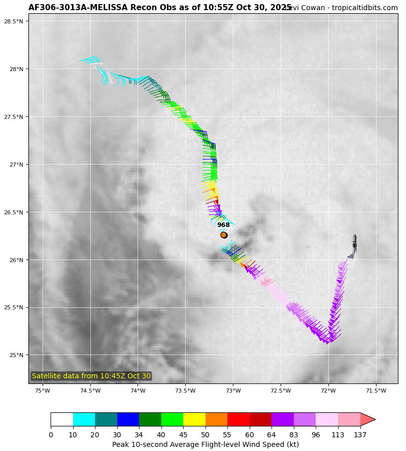
114 kt FL winds recorded. Pushing cat 3 again. She just won't give up.
-
Major Hurricane Melissa - 892mb - 185mph Jamaica landfall
cptcatz replied to GaWx's topic in Tropical Headquarters
Looks like White House should have clear skies right now. Crawford may be just inside the eye right now. Hopefully Josh can have a few minutes of sunshine to go outside and document. -
Major Hurricane Melissa - 892mb - 185mph Jamaica landfall
cptcatz replied to GaWx's topic in Tropical Headquarters
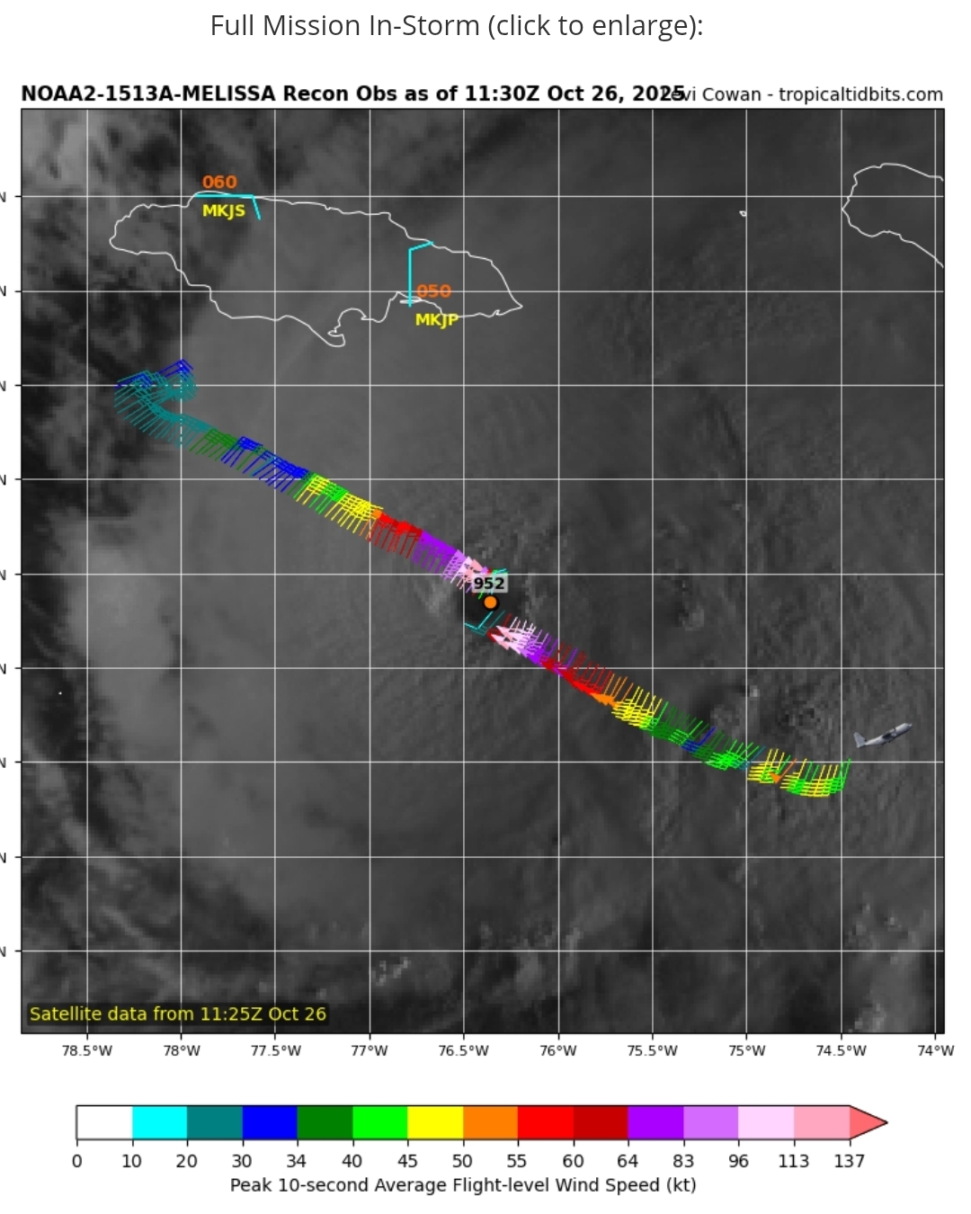
892, 185 mph. Landfall at this intensity would tie 1935 as strongest ever. -
Major Hurricane Melissa - 892mb - 185mph Jamaica landfall
cptcatz replied to GaWx's topic in Tropical Headquarters
The 1935 Labor Day Hurricane was the only Atlantic hurricane to make landfall below 900 mb, which hit at 892. This can very well be the strongest ever to make landfall. -
Major Hurricane Melissa - 892mb - 185mph Jamaica landfall
cptcatz replied to GaWx's topic in Tropical Headquarters
This will probably be up there with Dorian as his craziest eye. Anyways, recon about to go through the eye... -
Major Hurricane Melissa - 892mb - 185mph Jamaica landfall
cptcatz replied to GaWx's topic in Tropical Headquarters
And the 5am and 11pm -
Major Hurricane Melissa - 892mb - 185mph Jamaica landfall
cptcatz replied to GaWx's topic in Tropical Headquarters
Did that pass miss the center? -
Major Hurricane Melissa - 892mb - 185mph Jamaica landfall
cptcatz replied to GaWx's topic in Tropical Headquarters
Almost looks like a giant supercell you'd see in Oklahoma -
Major Hurricane Melissa - 892mb - 185mph Jamaica landfall
cptcatz replied to GaWx's topic in Tropical Headquarters
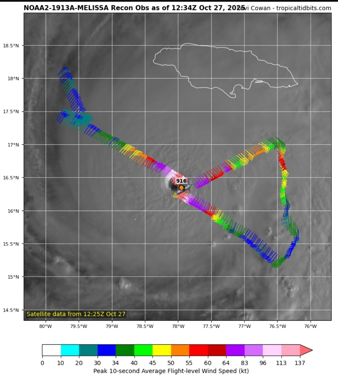
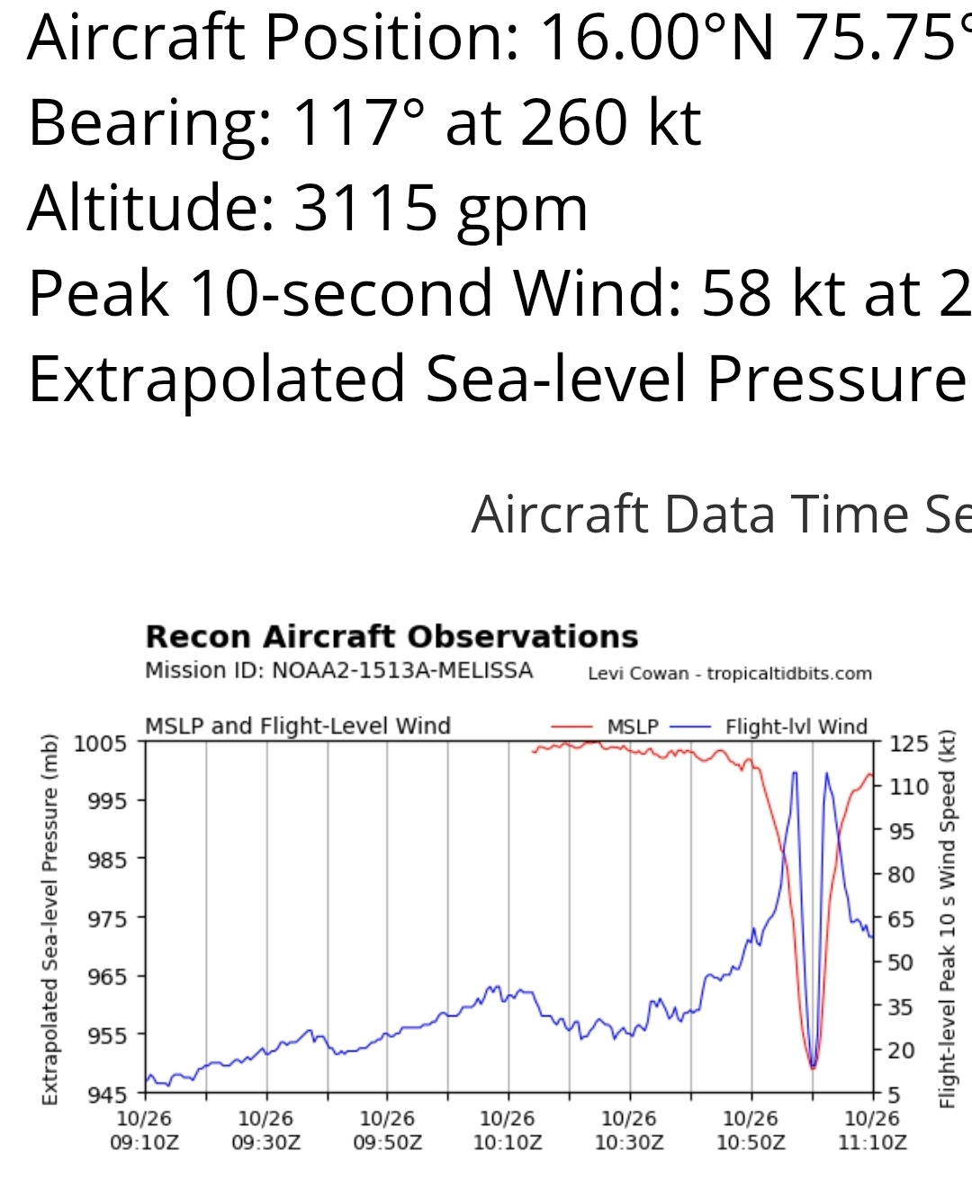
Looks like it's bottoming out with this latest pass. Pressure still around 910 and FL wind still at 156 kt. -
Major Hurricane Melissa - 892mb - 185mph Jamaica landfall
cptcatz replied to GaWx's topic in Tropical Headquarters
If an ERC happens soon, it could mean much worse impacts over bigger areas. Right now the storm is really small. If it turned north right now, eastern Jamaica wouldn't even get hurricane force winds and surge would be minimal outside of the small core.
-
Major Hurricane Melissa - 892mb - 185mph Jamaica landfall
cptcatz replied to GaWx's topic in Tropical Headquarters
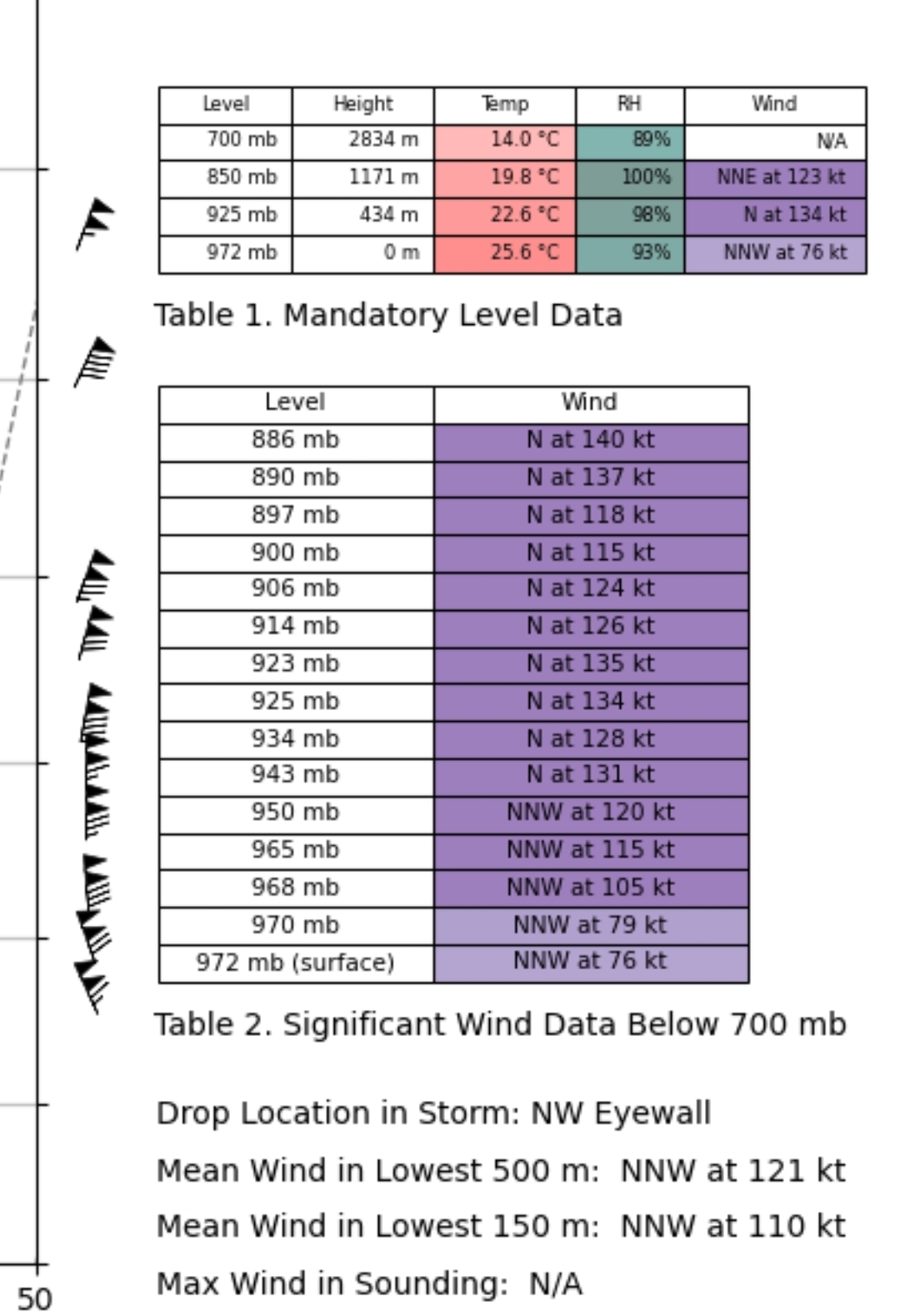
Recon first pass: 155 kt FL winds, pressure 912, incredible dropsonde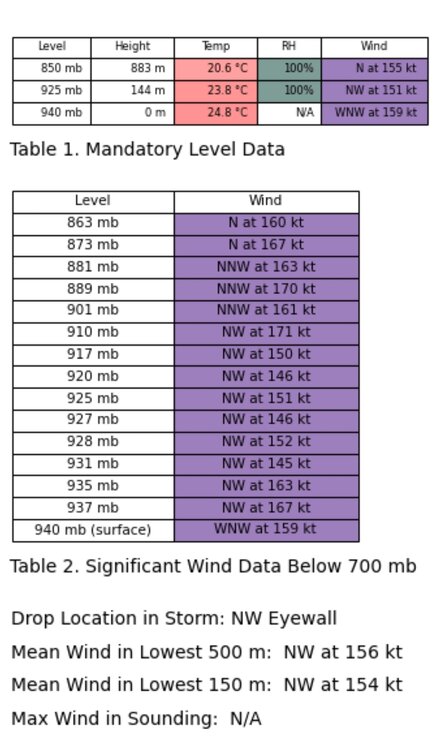
-
Major Hurricane Melissa - 892mb - 185mph Jamaica landfall
cptcatz replied to GaWx's topic in Tropical Headquarters
Except 11 hours late. It was not a 140 mph storm when they said it was at 5am. It strengthened into a 140 mph storm throughout the day. -
Major Hurricane Melissa - 892mb - 185mph Jamaica landfall
cptcatz replied to GaWx's topic in Tropical Headquarters
Looks like the plane is going home. Anyone know when the next flight is scheduled? -
Major Hurricane Melissa - 892mb - 185mph Jamaica landfall
cptcatz replied to GaWx's topic in Tropical Headquarters
I'm no expert on the socioeconomics of Jamaica but I would guess the tourist areas would fare better than the higher poverty areas of Kingston. Kingston getting the worse of it would likely cause a humanitarian crisis. -
Major Hurricane Melissa - 892mb - 185mph Jamaica landfall
cptcatz replied to GaWx's topic in Tropical Headquarters
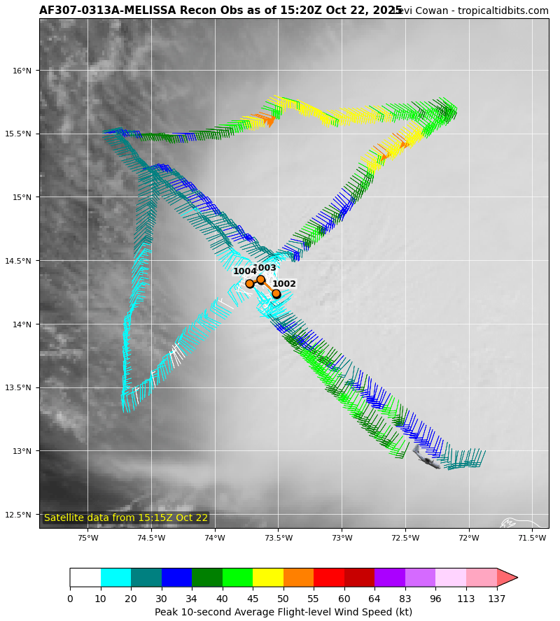
Second pass: slightly higher winds in the NE eyewall but no change in pressure and no support of 140 mph winds. -
Major Hurricane Melissa - 892mb - 185mph Jamaica landfall
cptcatz replied to GaWx's topic in Tropical Headquarters
Also interesting to note is this is a pretty small storm right now. Impressive winds barely reach past the eyewall.
-
Major Hurricane Melissa - 892mb - 185mph Jamaica landfall
cptcatz replied to GaWx's topic in Tropical Headquarters
Interesting dropsonde though. Really impressive winds higher up but not reaching down to the surface.
-
Major Hurricane Melissa - 892mb - 185mph Jamaica landfall
cptcatz replied to GaWx's topic in Tropical Headquarters
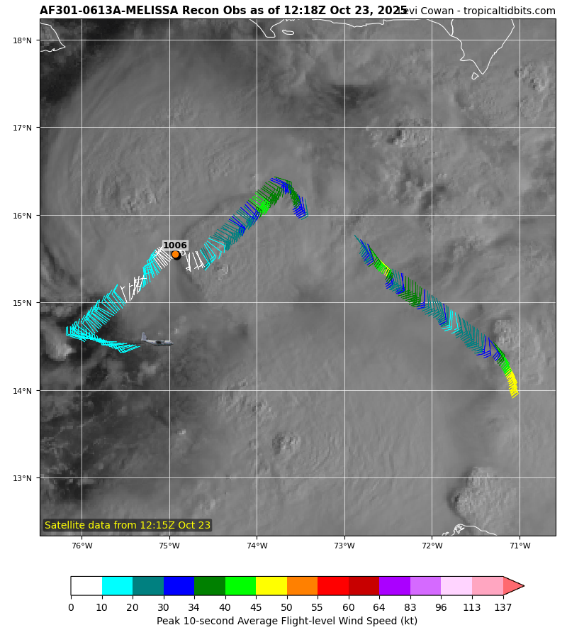
First pass of the morning shows it weaker than NHC estimated. Is it topping out?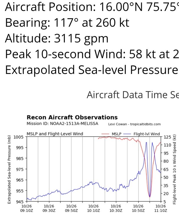
-
Major Hurricane Melissa - 892mb - 185mph Jamaica landfall
cptcatz replied to GaWx's topic in Tropical Headquarters
Good for surge, catastrophic for rain and subsequent mudslides. Think about 30+ inches of rain that is not going to get absorbed by the ground but just flow down the mountainsides down into the coastal plain areas. All those green areas are going to be flooded.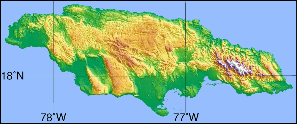
-
Major Hurricane Melissa - 892mb - 185mph Jamaica landfall
cptcatz replied to GaWx's topic in Tropical Headquarters
It's pretty amazing how bad the short term forecast was for the GFS. For days on end, it's two day forecast was hundreds of miles off. Hopefully NOAA makes some changes, pretty embarrassing. -
Major Hurricane Melissa - 892mb - 185mph Jamaica landfall
cptcatz replied to GaWx's topic in Tropical Headquarters
Lol what a mess. Just two days ago GFS thought this would be a bonafide category 2 hurricane.
-
Major Hurricane Melissa - 892mb - 185mph Jamaica landfall
cptcatz replied to GaWx's topic in Tropical Headquarters
As I type this it is 06z on Thursday 10/23 and Melissa is a sloppy weak tropical storm with a central pressure of 1002 mb. Let's look back and see what the GFS predicted Melissa would be at this time: 10/22 18z: 997 10/22 12z: 999 10/22 6z: 1003 10/22 00z: 999 10/21 18z: 988 10/21 12z: 981 10/21 6z: 984 10/21 00z: 977 10/20 18z: 976 10/20 12z: 970 lol why we would trust the GFS model right now? -
Major Hurricane Melissa - 892mb - 185mph Jamaica landfall
cptcatz replied to GaWx's topic in Tropical Headquarters
How close to florida do you think we could see? -
Major Hurricane Melissa - 892mb - 185mph Jamaica landfall
cptcatz replied to GaWx's topic in Tropical Headquarters
Pressure rising and wobbling southwest. Time to take GFS out back and shoot it. With king euro reigning, it'll be very interesting to see how strong this gets in the western caribbean sea.
-
Major Hurricane Melissa - 892mb - 185mph Jamaica landfall
cptcatz replied to GaWx's topic in Tropical Headquarters
06z gfs may be even worse. That shows like 10 straight days of TS/ hurricane impacts?