

JakkelWx
-
Posts
3,287 -
Joined
-
Last visited
Content Type
Profiles
Blogs
Forums
American Weather
Media Demo
Store
Gallery
Posts posted by JakkelWx
-
-
The radar looks anemic to my east.
-
1 minute ago, WxUSAF said:
SPC mesoanalyis now has the 850 0C line from southern end of 495 to Annapolis and then up the east side of the Bay toward Elkton. Big jump in the last few minutes, not sure what it saw to indicate that. But we're obviously getting colder aloft with people N/W switching to snow. Hopefully I do too soon...
The 2C 850 shifted from Goldsboro MD to Goldsboro MD
-
 1
1
-
-
Just now, nj2va said:
One of the things I'm trying to learn is how to read that map and tell if its a cold/dry look (I get the placement of the NAO/AO/EPO/etc). But to me that would seem to suggest NS dominated and/or cold/dry. Deepest low heights are centered over the great lakes.
That's just the general pattern going forward, and yes it does look cold and dry somewhat but the mean skews/washes out any PNA spike or brief relaxation in the block. The biggest plus in that map is we will actually have a real cold air source. It's game on essentially
-
 1
1
-
-
Pure model porn
-
4
-
-
That's a pretty good signal. Just need a high overhead and not a GL low.
-
1
-
-
Latest mesoanalysis has the 925 0C line right over my house and has shifted SE since earlier. 850s however are still about 3C. Probably explains the sleet.
-
Temp down to 35 but I can throw a rock into 32 degree temps. Sleet mixed with rain now
-
850s are down to 2C here, they should cool down even further and possibly flip back to snow around or before noon if precip is heavy enuf
-
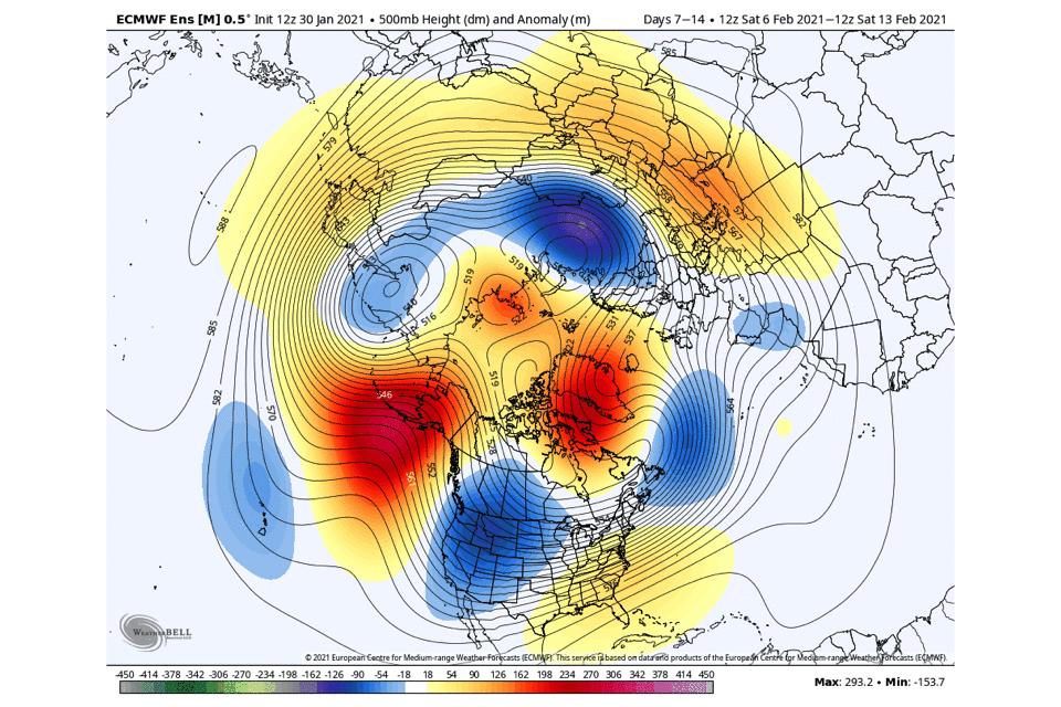
We have this pattern coming up from D6-D16.

-
5
-
-
33 minutes ago, CAPE said:
GFS and 3km NAM both have 5-6" in our area. The location and intensity of any precip tonight and tomorrow looks pretty iffy to me. Might see an inch or so is my guess.
How are we going to see only an inch when it's going to be snowing starting 1 PM today thru early morning Wednesday? We're likely going to see a few inches at least. That would be a pretty big bust to only see an inch of snow when we are 50 miles from a low that stalls for almost two days straight.
-
I'll take the 3k NAM depiction of 12 inches from backside snow
-
 1
1
-
-
Tomorrow it's gonna be Jan 32nd!
-
1
-
5
-
-
Based on the NAM improvements, I still like a general additional 1-2 inches on the backside, anything more is a bonus. Should be snow TV all day Tuesday
-
NAM improved
-
Is suppression still a risk for this storm?
-
5
-
-
-
Anyone got the 18z euro past just 42 hours? It's definitely still snowing on the backside then
-
Getting some heavy pingers
-
It's looking like maybe a brief period of heavy sleet/rain before being dryslotted, saving a lot of my snow.
-
Please just get us a pure miller A storm that we all get all snow from. Doesn't need to be a HECS or even a MECS
-
3
-
-
Yup this is one last hurrah before the mix line races north at the speed of light.
-
The only time it doesn't rain now is when we get two inches from a clipper
-
NWS New York just went for 18-24 inches for NYC and surrounding areas but who gives a crap about what they get
-
1
-
 2
2
-
-
Hopefully we and you all get a blizzard in 7 days.

-
1
-

Jan 31st - 33rd Storm Obs and Disco like it's 1979
in Mid Atlantic
Posted
I can tell the column is crashing on radar. I can see splotches of blue over Centreville MD, eastern shore.