

JakkelWx
-
Posts
3,364 -
Joined
-
Last visited
Content Type
Profiles
Blogs
Forums
American Weather
Media Demo
Store
Gallery
Posts posted by JakkelWx
-
-
storms have been constantly avoiding this location after a couple good hits earlier this month. time for it to reverse.
-
dover force field. THE STORMS WERE RIGHT THERE
-
 1
1
-
-
I see two boundaries heading towards each other. one in southern DE and an outflow boundary crossing the eastern shore. Maybe this will fire up some storms here.
-
100/67 at KGED (Georgetown DE) at 1:35 PM
98/73 at 1:55 PM in KDOV. Almost there
-
the lava from yesterday has already remelted and its not even 10 AM yet
-
Just now, frd said:
100 here today, an inferno.
KDOV and KGED both hit 100 today! Dover surpassed the all time record of 98 set last year by 2 degrees. via extremeweatherwatch
-
 1
1
-
-
I go in friends pool around 3 PM. Pool is 88. I come out of pool to dry off. I start sweating in 3 minutes. I go back in pool. Repeat
I go back home, turn the sprinkler on at 8 PM. I run through the sprinklers and get my head all wet. I dry myself off in front of big ass fan. I step away from fan and start sweating again within 5 minutes. I do the whole process again 3 more times, then i finally decide to go inside.
-
1
-
 1
1
-
-
43 minutes ago, MN Transplant said:
106 HI at the surface of the sun.
FYP
-
1
-
-
already a barn burner outside and its only 9 AM
-
Prepare to have your tastebuds slabbed.

-
1
-
2
-
 1
1
-
 1
1
-
-
3 hours ago, CAPE said:
Completely underwhelming yet again. 0.31" and a few rumbles of thunder. Maybe I can nickel and dime my way to half of normal rainfall for the month lol, although not much chance of anything over the 7 days. Currently at 1.6".
After baking for a week it will be desert-like here by next weekend
What the hell kind of "storm" was this? For an enhanced risk? Fork found in kitchen.
-
WHY do we keep doing this?
-
We need a classic night-time lightning barrage.
Did yall see that tornado in Somerset Nebraska today! Holy photogenic batman!
-
1
-
-
1.87"
0.10 in past hour. radar returns hanging on by a thread but ground truth is heavier. this reminds me of the back edge of a snowstorm when it sometimes re-fills in
-

After the storm
-
11
-
-
-
DOVER PUMMELED WOOOOOOO
-
outflow boundary from storms near smyrna moving through dover. i can see the millsboro cell from here. plenty of cumulus clouds just need an initiator
-
not a single breeze here! the tree leaves are dead calm. dews in the 70s. clearing out ahead of that line in NE MD here.
-
80% watch probs!

-
swarms of gnats in my yard this evening as the sun was setting.
-
8 minutes ago, CAPE said:
Just looked at all the Mesonet stations east of the bay- Only Stevensville has a somewhat respectable rain total- 0.41". Everywhere else is a quarter inch or less. A tenth here. Not confident in the overnight, but the forecast is still for a half to three quarters. I would have downgraded it to a tenth or less except higher amounts possible in thunderstorms. Doesn't look like much chance of a more widespread steady rain for this area.
about the same here
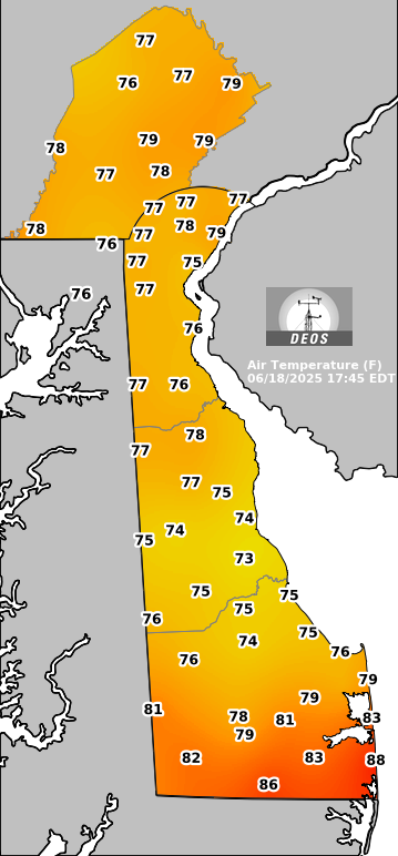
milford de only has 0.05 (via DEOS)

-
1
-
-
0.05 so far. drought busted
-
2
-
-
first bike ride of the spring, and many more to go. needs to be degreased, cleaned, then lubricated
3.69 miles at a zone 2/3 pace
-
1
-


July Discobs 2025
in Mid Atlantic
Posted
welcome to the swamps of dagobah!