

JakkelWx
-
Posts
3,287 -
Joined
-
Last visited
Content Type
Profiles
Blogs
Forums
American Weather
Media Demo
Store
Gallery
Posts posted by JakkelWx
-
-
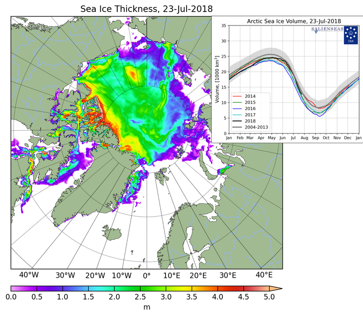
Current modelled ice thickness by the Danish Meteorological Institute. July 23. Notice that really thick ice in Baffin island.. Has that always been there?
-
 1
1
-
-
Eventually the WAR weakens a little/pushes a little east so areas east of the chesapeake bay start cashing in
GFS is very wet towards the end of the run with spots picking up 12''...
-
PWATS around 2.3''... yikes
-
Rained hard here overnight... 1.63''. Temp 81 DP 75 nearest PWS to me in Greensboro.
-
78/ DP 74
Picked up 0.06" so far today. 2.59" since Saturdays storm
-
Radar is red all over but just started weakening a little. Some lightning and thunder
-
Temp got down to 51/49. Now up to 68/60 beautiful morning.
-
57/53. Downright fall-like out.
-
A couple stations hitting 100. Probably in the sun. 97/78/114 here, down from 100 a little earlier. Grossest day since probably August 2016.
-
Lightningmaps.org is lighting up over Newark. It's like the geostorm lightning storm scene.
-
PWS has been at 100 since about 3 pm.
100/76/115
-
Back in Goldsboro. Nearest PWS topped at 100.8, so far. Back down to 96. DP 72 RH 46%
-
94/79 here. I am close by a corn field. Gross out.
July Discobs Thread
in Mid Atlantic
Posted
Cells coming from the south forming on CLD top phase satellite. and infrared suggests -50C cloud tops. Wouldn't be surprised if i get jolted in the next hour, although CAPE is kinda low. Off to bed.
http://weather.cod.edu/satrad/exper/?parms=meso-meso1-14-48-0-100-1&checked=map&colorbars=