Joshb32689
-
Posts
55 -
Joined
-
Last visited
About Joshb32689

Recent Profile Visitors


-
E PA/NJ/DE Summer 2026 Obs/Discussion
Joshb32689 replied to PhiEaglesfan712's topic in Philadelphia Region
Couple large limbs and branches down on our property from yesterday, but thankfully no damage. My wildflower bed is hurting after the wind - the pitfalls of chaos gardening. CAMs printing some hefty rain totals over Long Island in the short range. 12”+ in some cases. Some big rain potential down this way too. Currently seems maxed out at 6-8” in isolated spots. I’ll just take some steady rain today please and thank you. -
E PA/NJ/DE Summer 2026 Obs/Discussion
Joshb32689 replied to PhiEaglesfan712's topic in Philadelphia Region
While I despise this weather to my core, I think I can empathize with sun weenies now. I’m glad we didn’t get as crazy here….But I mean…. I’m curious to know what 120°F feels like? Missed the bullseye. Fall line jackpot. Update: Yesterday, 6 hour max air temp. topped out at 97.2°F. Observation max for today is 96.8°F. Heat index was the same at 108°F. So, a tie. -
E PA/NJ/DE Summer 2026 Obs/Discussion
Joshb32689 replied to PhiEaglesfan712's topic in Philadelphia Region
12:55pm : KMQS now running 1.4 degrees cooler than this time yesterday. Currently sitting at 93.6°F, DP 76.5°F (heat index 107°F, a degree shy of yesterday’s high). 1:35p Edit: still running 1.4°F behind same time yesterday -
E PA/NJ/DE Summer 2026 Obs/Discussion
Joshb32689 replied to PhiEaglesfan712's topic in Philadelphia Region
KMQS (Chester County airport) - 3 miles to my southwest. As of 2:35pm: 96.8°F, DP 70.9°F, heat index 105°F. I’m becoming more confident that we’ll miss triple digits at this point. ETA: Down to 96.1 at 2:55pm I was sitting in the DMV at KOP earlier. That’s when I learned that indoor swamp ass is a thing. @ChescoWx - how long has it been now since KMQS last broke 100? -
E PA/NJ/DE Summer 2026 Obs/Discussion
Joshb32689 replied to PhiEaglesfan712's topic in Philadelphia Region
91/78 outside of Coatesville as of 1115am. Thinking we don’t break 100 today That 106 heat index is something else though -
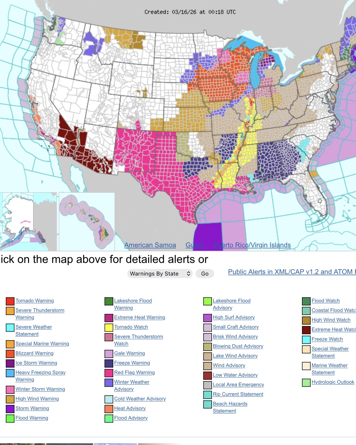
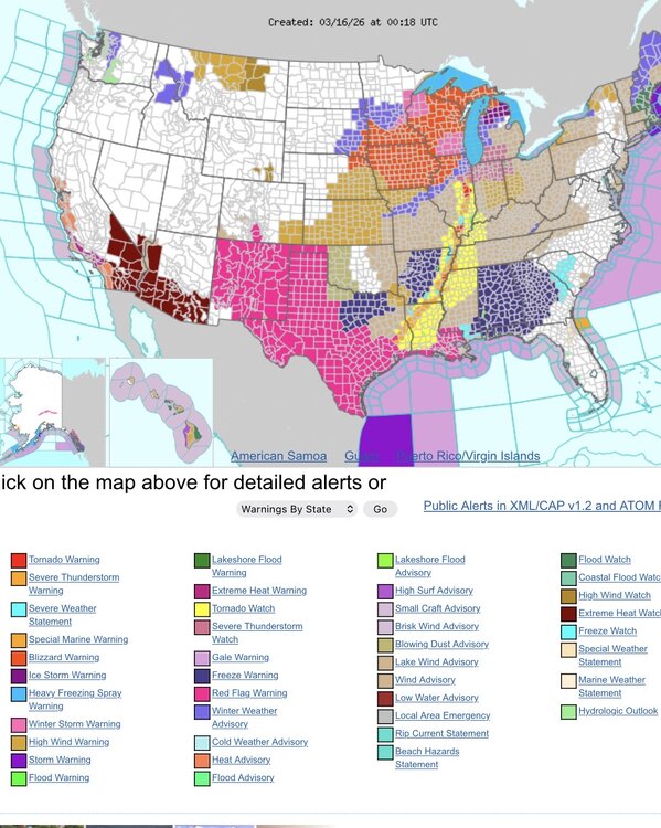
Quite the assortment of hazards across the country.
- 1,093 replies
-
- 3
-

-
- severe
- thunderstorms
- (and 1 more)
-
E PA/NJ/DE Spring 2026 Obs/Discussion
Joshb32689 replied to PhiEaglesfan712's topic in Philadelphia Region
Had some good sleet coming down for a bit outside of Coatesville. Lighter precip moving in, mixed back to rain. 39° F One of the wilder variations in temps and weather I’ve seen in awhile. 82 to sleet in the span of what, 36-48 hours? see if we can manage a little snow accumulation later -
4” just north of Coatesville
-
For the trolls (Mickey) and those living & dying by each hour model runs and worried about the trend (me) - HRRR & RAP stopped the bleed of the south and east trend with ticks back NW. Wet snow mixing in for the past 20 minutes in the Coatesville area. Slightly trimmed my expectations but still looking forward to a great storm.
-
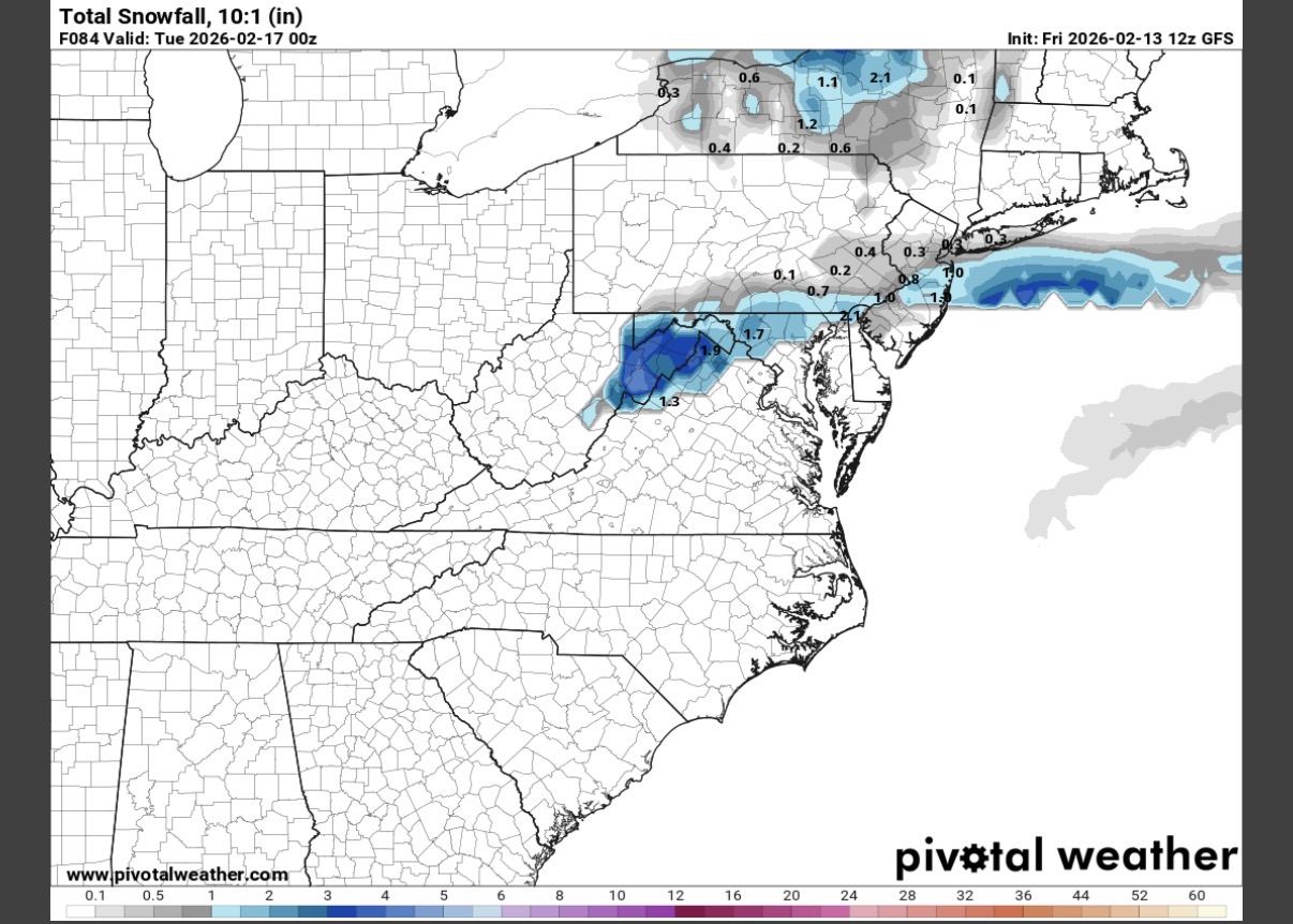
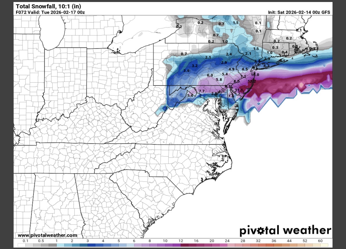
MQS range between HRRR and NAM is identical to our upgraded winter storm warning of 16-22”. Sounds like a solid call at the moment. Now just gotta pull the trigger on the blizzard warning - make it official. URGENT - WINTER WEATHER MESSAGE National Weather Service Mount Holly NJ 256 AM EST Sun Feb 22 2026 ...POTENTIALLY HISTORIC WINTER STORM WILL IMPACT THE REGION THROUGH MONDAY... .A major winter storm is expected to develop today, impacting the region with very heavy, crippling snowfall and areas of blizzard conditions. Precipitation will develop today, changing to all snow this afternoon and evening. The most severe conditions and heaviest snowfall will occur tonight, with snow gradually tapering off during the daytime Monday. Record breaking snowfall totals are possible. Western Chester-Eastern Chester-Western Montgomery- Including the cities of Oxford, Honey Brook, West Chester, Collegeville, Pottstown, and Kennett Square 256 AM EST Sun Feb 22 2026 ...WINTER STORM WARNING REMAINS IN EFFECT FROM 7 AM THIS MORNING TO 6 PM EST MONDAY... * WHAT...Heavy snow expected. Total snow accumulations between 16 and 22 inches. Winds gusting as high as 40 mph.
-
Where does one obtain the GEFS individuals? Would love to see some of those tucked solutions
-
E PA/NJ/DE Winter 2025-26 Obs/Discussion
Joshb32689 replied to LVblizzard's topic in Philadelphia Region
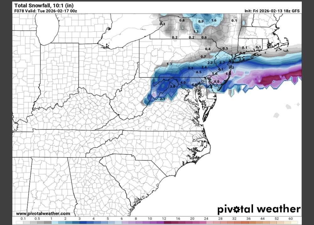
This seems far from settled 0z Euro vs 6z NAM
-
E PA/NJ/DE Winter 2025-26 Obs/Discussion
Joshb32689 replied to LVblizzard's topic in Philadelphia Region
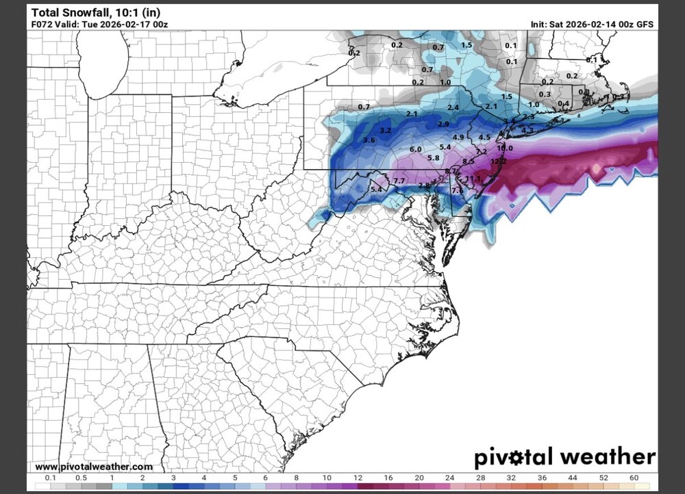
Quite the trend from 1am - 7pm. South Jersey went from 0 to over a foot in some spots

-
E PA/NJ/DE Winter 2025-26 Obs/Discussion
Joshb32689 replied to LVblizzard's topic in Philadelphia Region
https://x.com/WeatherProf/status/2022438348405481832 I don’t know what the GRAF is but damn -
January 24-26: Miracle or Mirage JV/Banter Thread!
Joshb32689 replied to SnowenOutThere's topic in Mid Atlantic
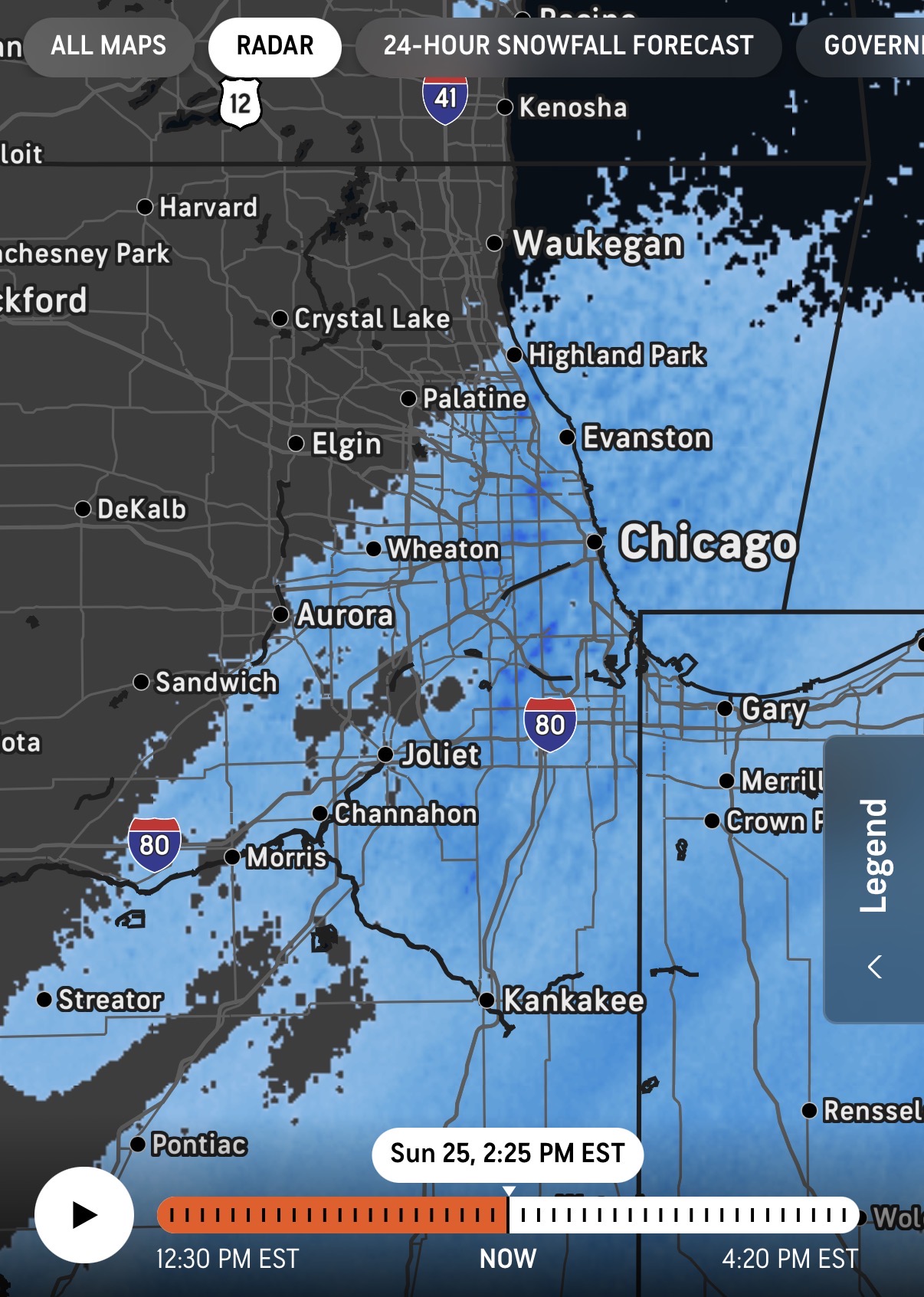
Meanwhile in Chicago they’re piling up lake effect