BhamParker
-
Posts
274 -
Joined
-
Last visited
Content Type
Profiles
Blogs
Forums
American Weather
Media Demo
Store
Gallery
Everything posted by BhamParker
-

2019/2020 Mountains and Foothills Fall/Winter Thread.
BhamParker replied to Tyler Penland's topic in Southeastern States
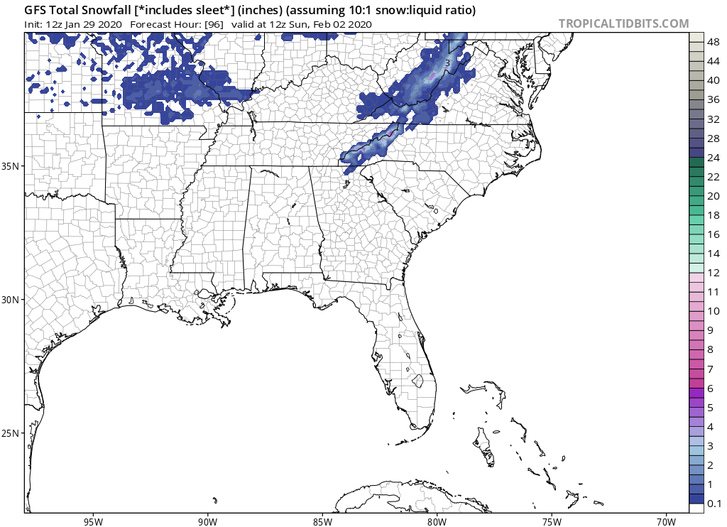
GFS looked great for the trailing wave!
-
2019/2020 Mountains and Foothills Fall/Winter Thread.
BhamParker replied to Tyler Penland's topic in Southeastern States
Hey it’s been consistent and CMC is kinda similar. Euro has been back and forth and the 12z EPS was the first bad run of the EPS in many runs. It could easily be wrong, but I sure won’t ignore it. -
2019/2020 Mountains and Foothills Fall/Winter Thread.
BhamParker replied to Tyler Penland's topic in Southeastern States
12km nam still looked good for WNC mountains. The weenie in me will hug that until the end.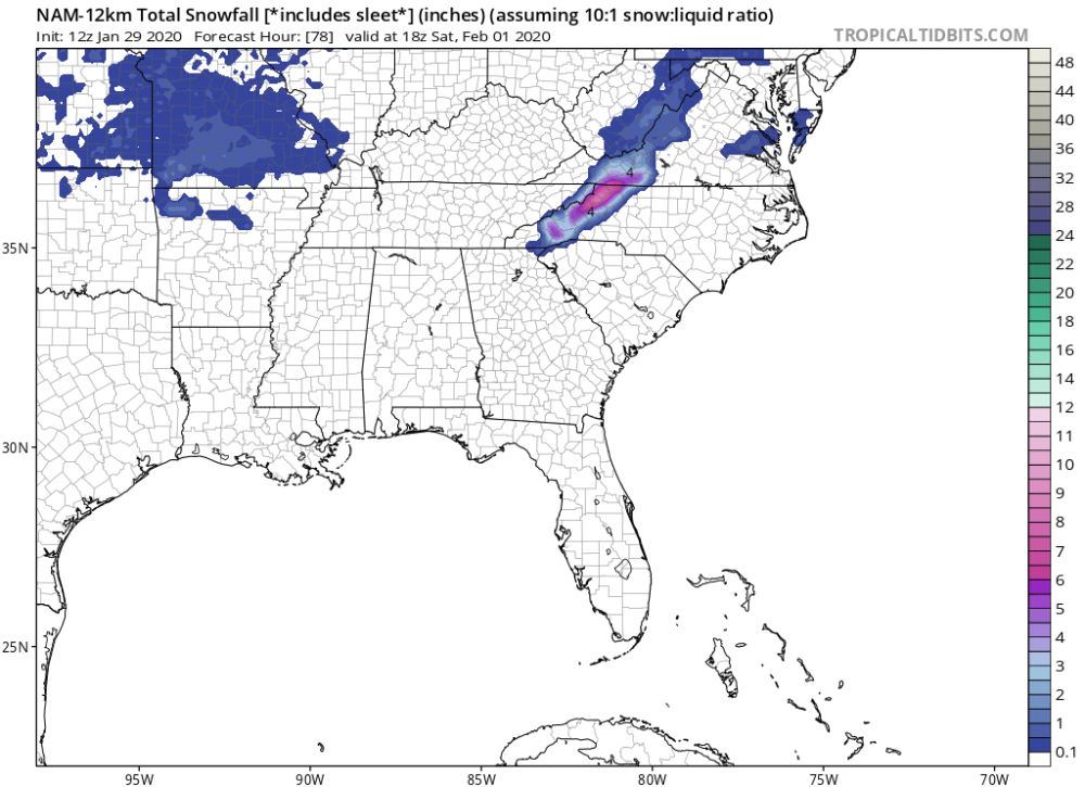
-
2019/2020 Mountains and Foothills Fall/Winter Thread.
BhamParker replied to Tyler Penland's topic in Southeastern States
All I can hope for is that being high in elevation will throw me a surprise. I’ve noticed with some of you over the last couple events, have been surprised with a couple of inches above 3500 feet and most models really weren’t showing much in the way of accumulation. I know some haven’t seen much, but at least I’ll have some kind of elevation on my side and I’ll drive up higher if I need to. -
2019/2020 Mountains and Foothills Fall/Winter Thread.
BhamParker replied to Tyler Penland's topic in Southeastern States
It really is nice. I got married down there back in August. If you are into waterfalls be sure to check out Soco Falls. It's roadside about halfway between Cherokee and Maggie Valley. Beautiful twin falls. Would be great to see in the snow. We are staying not far at all from Soco falls, so we will def have to check it out. We are about 3800 feet up and not far from the catalooche ski area. -
2019/2020 Mountains and Foothills Fall/Winter Thread.
BhamParker replied to Tyler Penland's topic in Southeastern States
I’m looking forward to my first trip to the mountains of North Carolina. Have heard from many people how beautiful Maggie Valley is. Hoping that this is the start of some good trends for all of us that will be in these areas. -
2019/2020 Mountains and Foothills Fall/Winter Thread.
BhamParker replied to Tyler Penland's topic in Southeastern States
Here’s a good one
-
2019/2020 Mountains and Foothills Fall/Winter Thread.
BhamParker replied to Tyler Penland's topic in Southeastern States
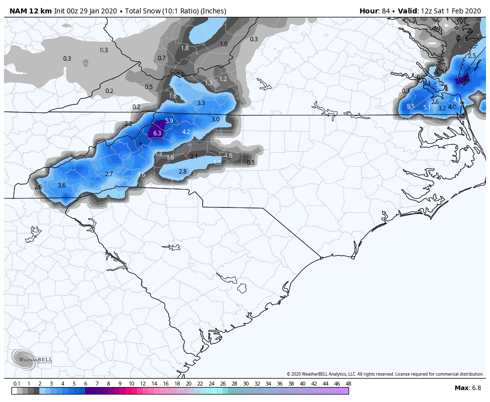
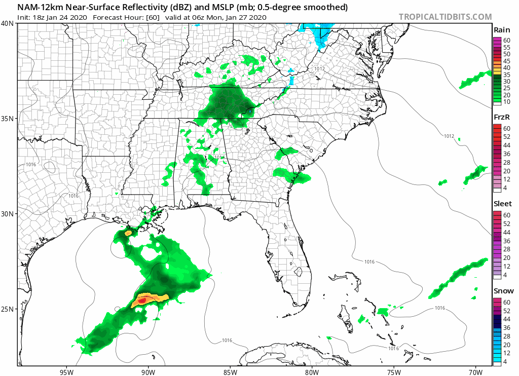
00z NAM starting things off in a nice direction... lots of moisture and coming in at night made for snow for just about the entire event for WNC mountains
-
2019/2020 Mountains and Foothills Fall/Winter Thread.
BhamParker replied to Tyler Penland's topic in Southeastern States
I am just hoping the latest Euro was correct and the earlier CMC was on to something. Clearly seems to be several different options on the table, but I am nervous about the situation. I'm not giving up just yet. -
2019/2020 Mountains and Foothills Fall/Winter Thread.
BhamParker replied to Tyler Penland's topic in Southeastern States
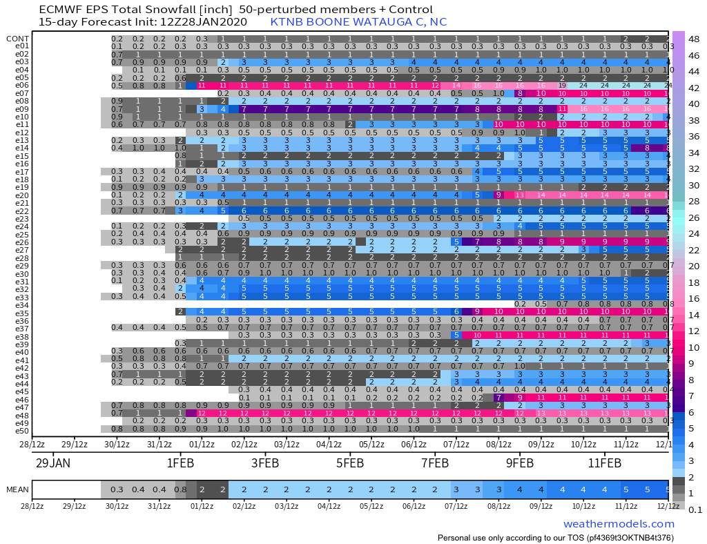
12z EPS with lots of different ways this could pan out. The threat is definetley very much still alive
-
2019/2020 Mountains and Foothills Fall/Winter Thread.
BhamParker replied to Tyler Penland's topic in Southeastern States
I feel like the 12z Euro was a nice step in the right direction.
-
2019/2020 Mountains and Foothills Fall/Winter Thread.
BhamParker replied to Tyler Penland's topic in Southeastern States
What a difference
-
2019/2020 Mountains and Foothills Fall/Winter Thread.
BhamParker replied to Tyler Penland's topic in Southeastern States
Model madness! -
2019/2020 Mountains and Foothills Fall/Winter Thread.
BhamParker replied to Tyler Penland's topic in Southeastern States
This dang storm better have some dynamic cooling. If this one busts, I’ll suspend myself from chasing forever -
2019/2020 Mountains and Foothills Fall/Winter Thread.
BhamParker replied to Tyler Penland's topic in Southeastern States
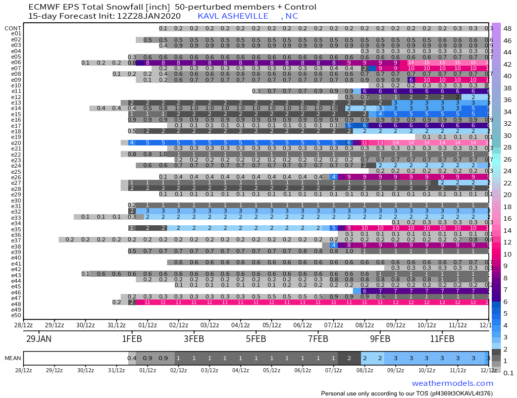
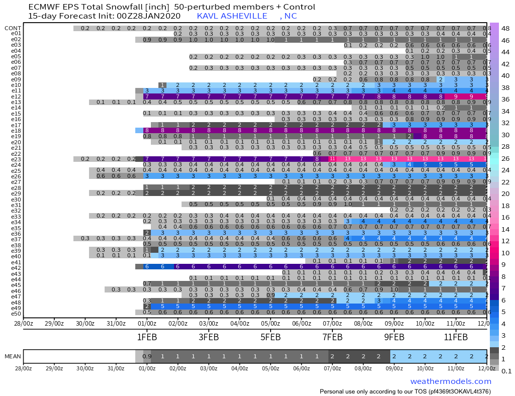
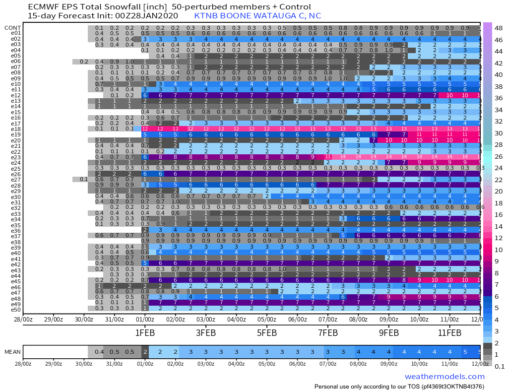
While the Euro may have been a whiff, the EPS is still fairly aggressive for the weekend. What is the best EPS chart to look at that would translate to a similar look for Maggie valley? I’ve just been choosing Asheville, but I’d imagine they’d do better then Asheville being at a higher elevation.

-
2019/2020 Mountains and Foothills Fall/Winter Thread.
BhamParker replied to Tyler Penland's topic in Southeastern States
I will be making my first trip to Maggie Valley this weekend. Our place will be 3,770 feet in elevation, so hopefully we will be okay. I am looking forward to the weekend! Great pics from today! -
2019/2020 Mountains and Foothills Fall/Winter Thread.
BhamParker replied to Tyler Penland's topic in Southeastern States
From MRX Of course our cabin is 2700 feet in elevation. I wonder if we will see any flakes at all from this. Oh so close!! Special Weather Statement National Weather Service Morristown TN 343 PM EST Sun Jan 26 2020 TNZ018-041-043-045-047-074-270945- Johnson-Cocke Smoky Mountains-Southeast Greene-Unicoi- Southeast Carter-Sevier Smoky Mountains- Including the cities of Doeville, Mountain City, Neva, Shady Valley, Trade, Laurel Bloomery, Hartford, Cedar Creek, Erwin, Unicoi, Limestone Cove, Hampton, Elkmont, and Gatlinburg 343 PM EST Sun Jan 26 2020 ...Minor snow accumulations possible across the highest elevations... An upper level disturbance will slide across the area overnight into Monday afternoon. This system will bring snow showers across the highest elevations of our eastern mountains. 1 to 2 inches of snow is possible above 4000 feet with 2 to 3 inches possible above 5000 feet. Up to 5 inches of snowfall is possible at Mount leConte where the elevation is over 6000 feet. The best chance for accumulating snowfall will occur between 5 AM and noon on Monday. Travel may become hazardous as snow accumulates on higher elevation roadways. -
2019/2020 Mountains and Foothills Fall/Winter Thread.
BhamParker replied to Tyler Penland's topic in Southeastern States
Things don’t look to be trending very well for the early Monday morning system. Too warm at the surface. Bummer -
2019/2020 Mountains and Foothills Fall/Winter Thread.
BhamParker replied to Tyler Penland's topic in Southeastern States
GFS is warmer. Looks like this will come down to a few degrees either way. Will be interesting to watch it unfold. -
2019/2020 Mountains and Foothills Fall/Winter Thread.
BhamParker replied to Tyler Penland's topic in Southeastern States
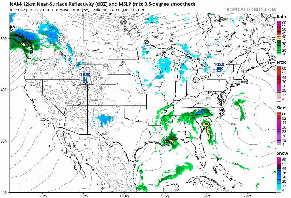
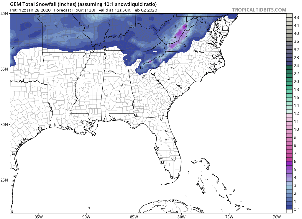
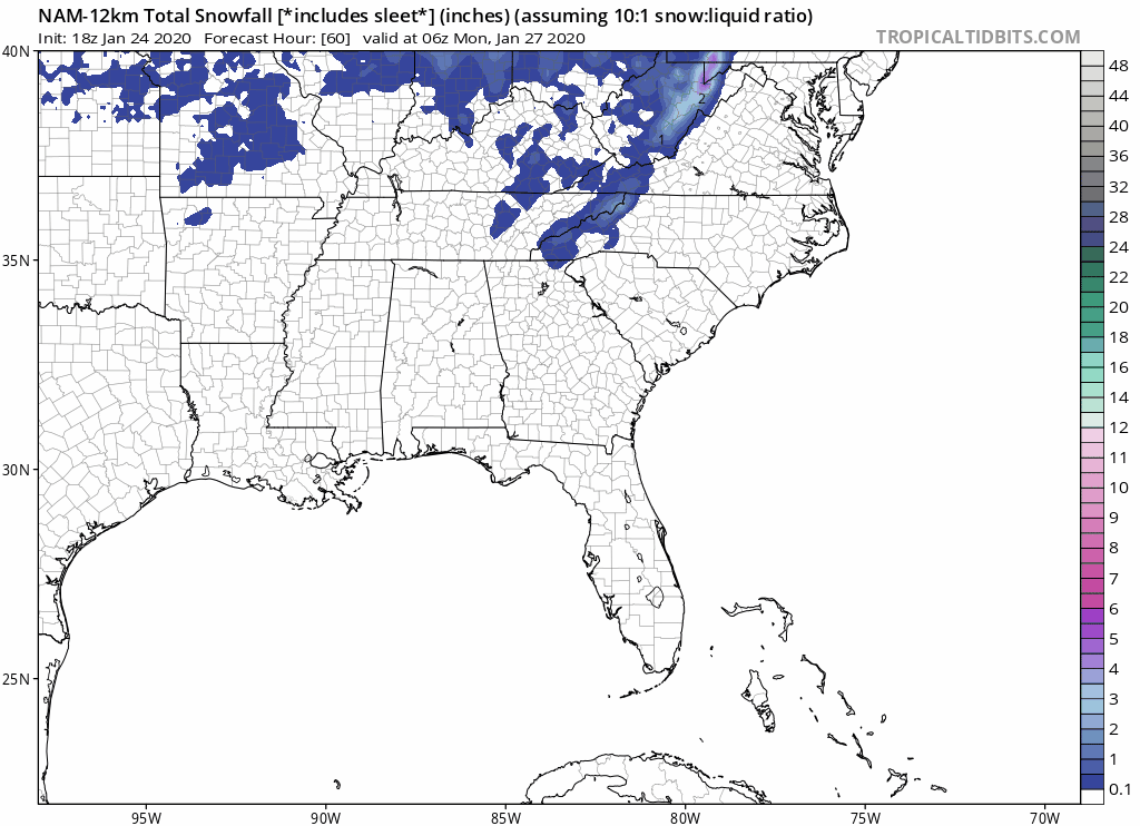
18z NAM looked interesting

-
2019/2020 Mountains and Foothills Fall/Winter Thread.
BhamParker replied to Tyler Penland's topic in Southeastern States
Euro looked like it puts down 1-3 inches in the mountains early monday morning. Would yall consider 2600 feet up high enough to see some snowfall this weekend or Monday morning? -
2019/2020 Mountains and Foothills Fall/Winter Thread.
BhamParker replied to Tyler Penland's topic in Southeastern States
GFS is SO close to something nice, temps are just a few degrees off -
2019/2020 Mountains and Foothills Fall/Winter Thread.
BhamParker replied to Tyler Penland's topic in Southeastern States
Tonight’s NAM and RGEM got me pretty excited as well. -
2019/2020 Mountains and Foothills Fall/Winter Thread.
BhamParker replied to Tyler Penland's topic in Southeastern States
Yeah the Euro and EPS is not pretty at all for this weekend. Latest NAM seems like it has some more NW flow action, but it is only out to 63 hours... Hoping that the higher resolution models will look more encouraging. The RGEM looks decent. -
2019/2020 Mountains and Foothills Fall/Winter Thread.
BhamParker replied to Tyler Penland's topic in Southeastern States
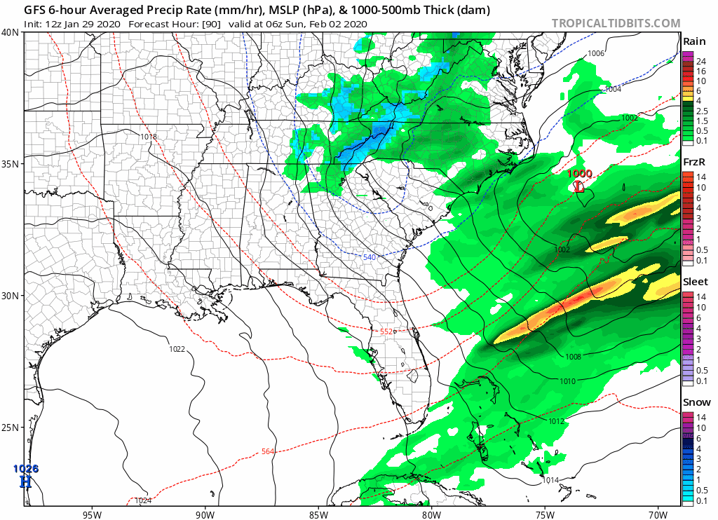
Man, sunday night and monday morning is getting a little sneaky. Canadian and GFS are very close it seems like. I am hoping for a surprise in the mountains in Gatlinburg this weekend. We will be leaving Monday around lunch. 9 of 20 members from the GEFS have 1 inch of snowfall in Knoxville, so maybe they are sniffing something out. EPS will be interesting at 12z