

Shocker0
-
Posts
573 -
Joined
-
Last visited
Content Type
Profiles
Blogs
Forums
American Weather
Media Demo
Store
Gallery
Posts posted by Shocker0
-
-
57 minutes ago, John1122 said:
Snowfall Map from yesterday and then today regarding this system. They cover the same timeframe. I don't know how the map changes this much for the same time period 24 hours later. The sad thing is that both are wrong, but the updated one is even more wrong. Things like this is why the significant winter storm snowfall maps end up looking way off years later and why the snowfall record doesn't line up with our memories and observations.
The updated map has Scott County with nothing to a dusting. They had 6-8 inches. It has snow totals in my area at 50% of what actually fell. Among my friends at various parts of the county there was 10 near the Claiborne line, 8 in Jellico, 8 in Jacksboro, 10 in LaFollette, 8 in Caryville.
You guys can decide if either lined up for your area. The first map was close here.
Map from yesterday.
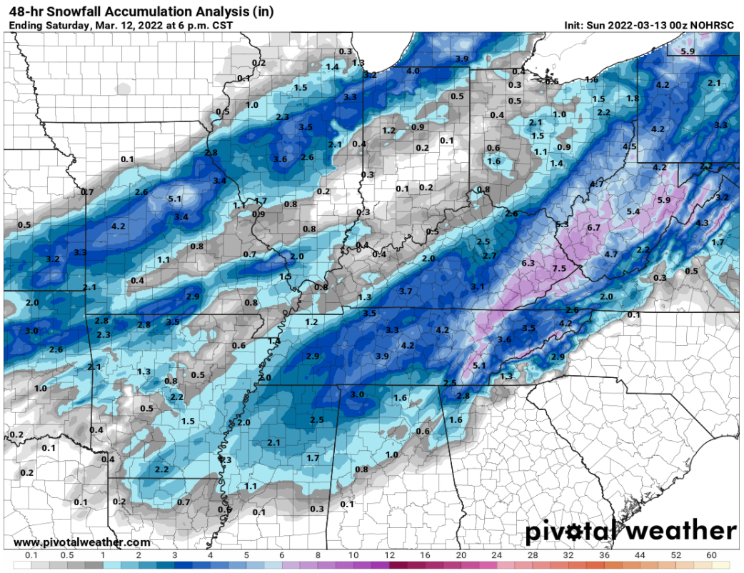
Map from today.
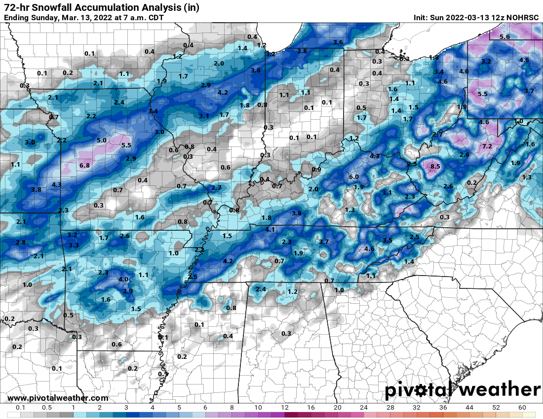
That's weird. Both seem way off. The second one doesn't even seem for this event. The first has the line of heavier snow fairly accurate though. But some other areas seem way underdone, like Knoxville, and especially Arkansas. The second map seems more accurate for Arkansas and Western Tennessee though.
-
20 minutes ago, Snownado said:
Is your snow melting pretty fast?
Now it is, yeah. I don't have any shade in my yard and it's up to 39 degrees. Anything that is left today will surely be gone tomorrow.
This camera is about 10 miles east of here: https://www.wate.com/weather/weather-cameras/fairfield-glade/
-
 2
2
-
-
10 minutes ago, Snownado said:
There's no freakin way it went from 5 to 35 in just 4 hours especially since you say you have cloud cover ?
The low temp was about 2am, so actually it happened closer to 10 hours ago. When I got up around 6am it was already up to 15, probably from when the clouds started rolling in. Now it's completely sunny again. Seems pretty possible to me. Mayland near me is reporting 35 right now as well and was 10 last night. I figured my station was off on temps but it looked similar to other nearby stations overnight. I was just going off what my station said. Snow cover + clear skies can cause the temperatures to plummet pretty quickly and then rise again as cloud cover moves in and wind shifts from the south.

-
1
-
-
1 hour ago, Silas Lang said:
My station reads a low of 12 this morning.
My totals for the year are at 12 inches. Well above average due to this storm. Not sure how to rate the winter overall. January was great with a bunch of smaller events and cold. This storm was of course amazing, making it an excellent March. But December and February were terrible for snow lovers in the valley. However, the results don't lie so I have to give this Winter an A.
It is something to think about when looking at the historical record. An awesome winter on paper still can have stretches of warm and snowlessness.
Anyway, bring on the spring. I am ready for it now. I will see you guys next season. It has been fun!
My station bottomed out at 5 last night NW of Crossville, but is already up to 35 today. It may be somewhat accurate because I did see a station 15 miles east reporting 5 degrees, and another 7. It seemed to melt more yesterday than today so far, but we've also had cloud cover today.
Winter wasn't great in Knoxville this year but I have to think going out with such a bang like that makes it jump way up. If this storm happened in November or December and the rest of the winter was lackluster, it'd feel a lot more disappointing I would imagine

-
4
-
-
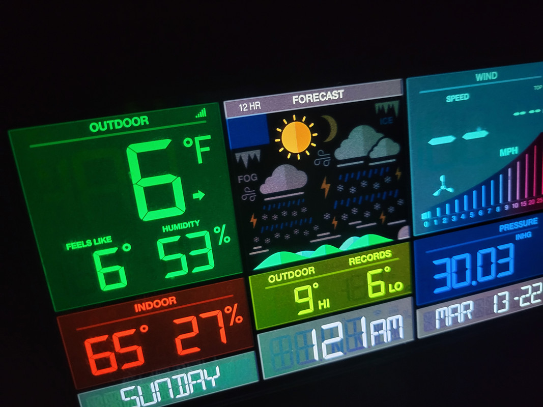
8 degrees currently here if my weather station is to be believed. Seems too low though
Edit: now down to 6. My device may run too cold or too warm at times maybe because Crossville is reporting 10 currently. The previous low this winter was either 7 or 8 for me
-
6
-
-
Crossville towercam. I've never seen it look like this before. The camera should be pointing right toward main street but really can't make anything out

-
4
-
-
7 minutes ago, John1122 said:
Down in LaFollette, roads are now covered.
When I first clicked I saw flakes in the left side of the screen just blowing around randomly and for some reason I thought it was bees or insects for a second haha. It just looked way out of place compared to the rest of the video lol.
-
3 minutes ago, Dsty2001 said:
Is it very fine snow Shocker? Reminds me of some super high ratio snow I've seen before
[edit]
Doesn't seem like it would accumulate quick but from my experience it does
I was disappointed because I thought it had quit earlier lol, even though it still showed on radar. Then I went outside and could see it clearly. It's 24 here now and feels like 10. Unusual for such high ratio snow in Mid-March. It's just blowing everywhere so not gonna be the "pretty" snow like usual probably but will add up quicker maybe.
-
1 minute ago, Dsty2001 said:
Is it very fine snow Shocker? Reminds me of some super high ratio snow I've seen before
Yeah it's fine, barely can see it when I look at my security cam, but when I go outside it's really obvious in the street light. There is no snow on my vehicle to note because of how dry and windy it is.
-
1
-
-
Dry powdery snow here. The wind is insane, looks like a blizzard at times. Flakes still aren't huge either but have gotten bigger from earlier. I can't stand to be out in it very long.

-
2
-
-
16 minutes ago, PowellVolz said:
The web cam in Cookeville shows snow about an hour ago. How much do you have?
.It's actually pretty steady now that I actually went outside, but the flakes have become really fine and the wind blowing so hard made them hard to see on the security camera. Here's a pic. It'll have to pick up in intensity soon though to amount to much. It's starting to stick on our little road though.

-
2
-
-
3 minutes ago, PowellVolz said:
The web cam in Cookeville shows snow about an hour ago. How much do you have?
.Only about 1.5" so far. It has actually very light at the moment. Looks like the southern end of the county may have gotten a good bit so far if the radar was actually snow. I'm surprised Jamestown would be graupel though as they usually would have snow while everywhere else could still be rain.
-
1
-
-
Someone in Jamestown said tthey're getting graupel there. Very weird.
-
1
-
-
Snowing hard now, dusting forming quickly on cars
-
4
-
-
32 now here and light snow
-
5
-
-
3 minutes ago, Wintersnow888 said:
Interesting....had several customers tell me they heard on local radio ( the TV met report) that areas in Cumberland county were getting 10 Inches ...I listened on way from town but didn't hear it ....oh well don't know what to make of that !?!
Some models yesterday had us anywhere from 8-15" at times. But today it seems like it shifted the heavier stuff East. We'll see though. I'd say 3-6" is probably a good possibility which is what the WSW is for.
-
2
-
 1
1
-
-
I-40 East of Jackson:

-
7
-
1
-
-
Now down to 34 with a brief lull in precip before all snow hits here NW of Crossville.
-
3
-
-
Incredibly, snow has somehow begun to accumulate on roadways throughout the Nashville area despite temperatures around 70 earlier today. This phenomenon was previously thought to be impossible by some local meteorologists. It remains to be seen how quickly they forget this before the next snowfall hits the area.


-
5
-
1
-
 4
4
-
-
1 minute ago, Wintersnow888 said:
Just got home from work and it changed from rain to sleet as I drove from Crossville
Yeah I drove from town and it wasn't doing anything, and felt about 5 degrees warmer. Then started sprinkling right off Exit 311. Looks like it'll change to snow very shortly. Weather Channel has lowered us to 1-3" though
-
4
-
-
12 minutes ago, Shocker0 said:
Sprinkles in Crossville. 38
36 now and sleet
-
5
-
-
Sprinkles in Crossville. 38
-
2
-
-
NAM is incredible for all of ETN
-
3
-
-
Down to 47 here NW of Crossville. It was 60 about an hour ago.
-
3
-
March 11th-13th Winter Weather Event. Winter's last gasp?
in Tennessee Valley
Posted
Yeah, that's what I was saying. The second one is just way off to the point it looks like it was referencing a completely different storm. In Cumberland County it shows the western half with more snow than the right, which is usually true, but not in this storm I think. So it's immediately wrong in that regard, minus the complete blank for Scott County.
I wonder if the second map is based on reports and the areas that didn't report anything were literally left blank? Would be stupid but I can't think of anything since if anything the 72 hour map should look almost exactly the same as the 24, if not showing even more snowfall.