

purduewx80
-
Posts
1,554 -
Joined
Content Type
Profiles
Blogs
Forums
American Weather
Media Demo
Store
Gallery
Posts posted by purduewx80
-
-
8 minutes ago, CarLover014 said:
Could we be looking at a potential for thunder tomorrow?
slight chance morning thru midday.
-
39 minutes ago, NJwx85 said:
18z NAM really backed off on the strength of the convection for Saturday.
Yup, will probably see significant run-to-run differences continue. 18Z RGEM (below) and GFS coming in w/ a 2"+ QPF max near the city. The synoptic features are all similar enough, just a matter of where the forcing is able to take advantage of the lapse rates.

-
7 minutes ago, TriPol said:
Are any of these storms potentially severe? Imagine a severe t storm warning... in January!
No, low levels are very stable; the instability showing up is based near 3000-4000' above the surface. Could be some perky winds on NJ/LI coasts but nothing widespread or severe. Could be some small hail though.
-
Saturday's rain event may have a convective component as the potent upper low currently over TX (and its steep lapse rates) passes through the region. Initial WAA could produce a thunderstorm or two in the early morning, but it appears more likely that thunderstorms will feed into a redeveloping deformation band as the shortwave goes negative-tilt while passing S of LI later in the morning or early afternoon. The surface low deepens ~10mb in 12 hours as well. NAM 3k goes wild with widespread 1-3" rainfall over NYC and local amts over 4", though most other guidance predicts up to 1" of rainfall. The location of all this is likely to change given the mesoscale nature of this forcing, but it could make for an interesting start to the weekend.

-
The New Year's Day high temp record could be in jeopardy at KNYC. Most of the 2m and MOS guidance currently falls short, but if the WAA regime (50-60KT SWrly jet at 925mb) during the pre-dawn hours overperforms, surface temps could easily reach the lower 60s. Central Park's Jan 1 record high of 62 occurred in 1966. The record high min for the day of 52 is safe given strong cold advection progged during the PM hours.
-
 2
2
-
-
Just now, nycwinter said:
did anyone see that for a minute their was this bright light that illuminated the dark skies as i was facing queens.. looked to me like some sort of huge fire but now it is out now....
electricity blinked in and out in LIC for a minute or so
-
00Z EPS is noticeably warmer in the East through the first few days of the New Year than its previous run. The SE/Carib ridge flexes continually, largely making any cold intrusions into the Northeast muted and quick-hitting. Surface high placement will be critical, but with an active pattern for the foreseeable future, it's possible for some front-end thumps as WAA rushes in with each system. I think overall the interior around here will be favored for any wintry precip, but it can't be ruled out. Most importantly, this pattern should also rebuild snow cover in northern New England and Eastern Canada in the coming 2 weeks.
Massively higher heights shift into the Gulf of Alaska at the same time, then build from the Arctic to Baja by the end of the run. That allows frigid air spilling into the West initially to press east with time. Obviously, it may and likely will change down the road, but it absolutely supports a lot of the long-term thinking for a transition to much colder conditions by the 2nd week of the New Year.
-
3
-
-
14 minutes ago, Snow88 said:
JFK and LGA arent in Long Island
Maybe from the perspective of a NYer. Not from the perspective of literal, actual geographical location.
-
1
-
 1
1
-
-
3 minutes ago, psv88 said:
All of the LI stations reported snow at one point
Not true considering that JFK and LGA are on LI.
-
1
-
-
EWR is the only immediate NYC-area station to have observed snow overnight (-RASN). NYC, LGA, JFK only reported light rain.
-
5 hours ago, Snow88 said:
Eps shows otherwise
it doesn't, actually. goes into phase 8 near the 2nd week of january on its current iteration. eps 850 temp anomalies are placed similarly to but are a more muted in magnitude than those in the ecm run neg nao posted.
-
1
-
-
Just now, Snow88 said:
This doesn't look big but I can see Snow88 pitching a tent out of this. I think the coast will also see flakes but no accumulations.
fyp
")
-
33 minutes ago, dendrite said:
Nice. I had tried to remember to check that out last night. I guess that’s a new Dec record then?
According to the SPC sounding climo, it's a record for Dec, Jan, Feb, Mar, April. Only ever observed that high or higher from May - early Nov.
-
1.79" PWAT at CHH last night.
-
Favorable low level shear and CAPE have allowed for a few supercells to form in central PA.


-
2
-
-
56 minutes ago, NJwx85 said:
Not sure if this will have anything to do with later for us but the DC area, especially the Western side of town is experiencing quite a bit of thunderstorm activity currently. All of this is currently moving to the NNE.
it could for far northern jersey, but i think a lot of that over the mountains is driven by modest heating under the cold trough. it's getting a boost by the 500mb jet max working its way up the coast, as well. should mostly stay in MD, PA, upstate.

a lot going on, meteorologically. what's amazing about the new GOES hi-res vis is that you can see synoptic, meso- and microscale processes happening at once. the low sun angle and shadows it creates, thanks to today's solstice, help see what's happening in ~3D.
-
1
-
-
Just now, Rjay said:
Really looks like there's a gravity wave in there too
oh yeah, absolutely. can see them occasionally on WV/vis satellite too.
-
1
-
-
Just now, Rjay said:
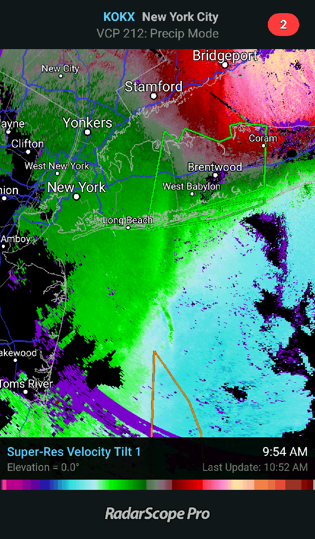
What is this feature currently passing through central Suffolk? Almost looks like outflow. GW?

Essentially a low level front associated with the LLJ, Notice winds to its east are SE and G30-40KT and to the west of it are much lighter from the S. These are the kinds of things that cause severe wind shear (that we saw at LGA earlier).
-
 1
1
-
-
Nice meso vort headed for suffolk over the next hour. Crazy winds aloft upwards of 85KT at 4000-5000'. Curious to see if any of this makes it to the surface.
-
ALB winter time PWAT record, OKX tied it. Both TLH and LIX set 500mb record low heights.
-
1
-
-
May add to this in the Mid-Atlantic/Appalachians and maybe Northeast today.
-
1
-
-
11 hours ago, purduewx80 said:
LIX tied the previous December 500mb height record low at 00Z this evening. This is a testament to how anomalous this system is and will be.

The majority of the forecast models have heights lowering to all-time record lows overnight, so the 12Z sounding will be fun to see. The spread in today's guidance is essentially 5410-5415m.
The previous lowest 500 height there going back to the late '40s was 5440m, set in March.

12Z at LIX at 5420m. New Record. Looks like OKX PWAT will be a new met winter record at 12Z.
-
LIX tied the previous December 500mb height record low at 00Z this evening. This is a testament to how anomalous this system is and will be.
The majority of the forecast models have heights lowering to all-time record lows overnight, so the 12Z sounding will be fun to see. The spread in today's guidance is essentially 5410-5415m.
The previous lowest 500 height there going back to the late '40s was 5440m, set in March.
-
2
-
-
6 hours ago, LibertyBell said:
Based on upslope and the storm tracking to the west of us, the rainfall maxima should be in the mountains of NW NJ and the Poconos.
Very well could be but it entirely depends on where the conveyor belt sets up and if it remains stationary tomorrow. There will continue to be variability in the modeling given the mesoscale nature of the event.


January 2019 General Discussion & Observations
in New York City Metro
Posted
Euro coming in hot for the 13th/14th; a lot like the past few runs of the EPS.