Sw NC weather
-
Posts
629 -
Joined
-
Last visited
Content Type
Profiles
Blogs
Forums
American Weather
Media Demo
Store
Gallery
Everything posted by Sw NC weather
-

2025-2026 Fall/Winter Mountain Thread
Sw NC weather replied to Buckethead's topic in Southeastern States
Light freezing rain at 31. A little concerning we were supposed to be 34 according to short range models at the time. -
2025-2026 Fall/Winter Mountain Thread
Sw NC weather replied to Buckethead's topic in Southeastern States
Don’t worry if this weekend doesn’t work out for snow for us. The GFS gives us a casual 24”-30” next weekend. -
2025-2026 Fall/Winter Mountain Thread
Sw NC weather replied to Buckethead's topic in Southeastern States
12z GFS is right where I like to see it. 12-18” for WNC of all snow. 20” in N Ga. Keeps us all snow -
2025-2026 Fall/Winter Mountain Thread
Sw NC weather replied to Buckethead's topic in Southeastern States
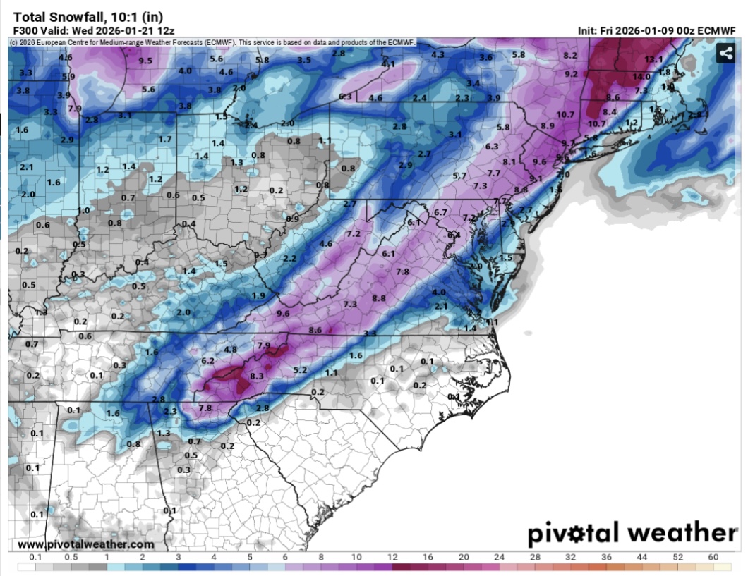
This is turning into something historical. May still shift one way or another. But somewhere in the southeast is going to be shut down for a week or more. The euro and gfs are crazy. -
2025-2026 Fall/Winter Mountain Thread
Sw NC weather replied to Buckethead's topic in Southeastern States
Might have to go pour a shot. What a run! Still light snow going on at this point. 18-24” for WNC!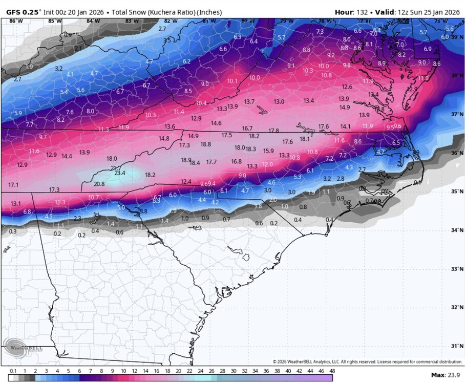
-
2025-2026 Fall/Winter Mountain Thread
Sw NC weather replied to Buckethead's topic in Southeastern States
Let’s keep it down there till Wednesday. This could get fun yall if everything lines up perfectly. It’s been a while. -
2025-2026 Fall/Winter Mountain Thread
Sw NC weather replied to Buckethead's topic in Southeastern States
No snow at my place at 2300’ this morning. Go up 200’ in elevation and you start seeing some. I rode up the mountain to around 3500’ and there was a solid inch. Short range models are looking a little interesting for maybe a dusting tonight. -
2025-2026 Fall/Winter Mountain Thread
Sw NC weather replied to Buckethead's topic in Southeastern States
Same exact thing here in northern Macon. I’m assuming the flow didn’t set up to well. That wind has some serious bite though. -
2025-2026 Fall/Winter Mountain Thread
Sw NC weather replied to Buckethead's topic in Southeastern States
All snow in northern Macon county. Hopefully I can pick up an inch tonight. Good luck everyone and stay safe. -
2025-2026 Fall/Winter Mountain Thread
Sw NC weather replied to Buckethead's topic in Southeastern States
Nice snow shower here this morning in northern macon county. -
2025-2026 Fall/Winter Mountain Thread
Sw NC weather replied to Buckethead's topic in Southeastern States
Boarder counties are smoked by both systems. 12”+ rest of the mountains are in the 6-12” range.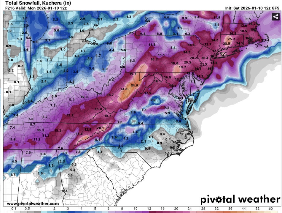
-
2025-2026 Fall/Winter Mountain Thread
Sw NC weather replied to Buckethead's topic in Southeastern States
Icon ended with a nice event to unfold for us in my opinion. Probably a 3-6” thing for most of the mountains.
-
2025-2026 Fall/Winter Mountain Thread
Sw NC weather replied to Buckethead's topic in Southeastern States
0z Euro with a nice one two punch.
-
2025-2026 Fall/Winter Mountain Thread
Sw NC weather replied to Buckethead's topic in Southeastern States
I agree with met I think the northern mountains will be the sweet spot for this one. Looks like a good bit of moisture and shouldn’t have temp issues like people south and east of them. -
2025-2026 Fall/Winter Mountain Thread
Sw NC weather replied to Buckethead's topic in Southeastern States
Picked up 2.25” in Northern Macon County with a low of 19 this morning. A nice surprise to start winter in early November. -
2025-2026 Fall/Winter Mountain Thread
Sw NC weather replied to Buckethead's topic in Southeastern States
Had a heavy burst come through Franklin. Lasted 10-15 minutes. Coated everything other than the rd in a 1/4-1/2”. -
2025-2026 Fall/Winter Mountain Thread
Sw NC weather replied to Buckethead's topic in Southeastern States
Light to moderate snow at the moment and a light dusting already. Really wasn’t expecting much more than flurries before this evening so this is a early win in the event for me on this part. -
2025-2026 Fall/Winter Mountain Thread
Sw NC weather replied to Buckethead's topic in Southeastern States
Had 35 and a frost in cowee this morning. First of the year -
2025 Spring/Summer Mountain Thread
Sw NC weather replied to Maggie Valley Steve's topic in Southeastern States
Was about to say the same thing we’ve got a crazy storm blowing up just to the north of the tons of lighting and rains getting heavier. NWS just issued a special weather statement for 40 mph winds and 1/2 inch hail -
2025 Spring/Summer Mountain Thread
Sw NC weather replied to Maggie Valley Steve's topic in Southeastern States
No joke. I’ve already lost power, hoping they can fix it before the main show gets here or it may be a day or two. -
2024-2025 Fall/Winter Mountain Thread
Sw NC weather replied to Buckethead's topic in Southeastern States
A dusting here maybe up to a 1/2” on elevated surfaces. Still light snow falling. -
2024-2025 Fall/Winter Mountain Thread
Sw NC weather replied to Buckethead's topic in Southeastern States
A few flakes mixing in at the moment down this way. Temp down to 38. -
2024-2025 Fall/Winter Mountain Thread
Sw NC weather replied to Buckethead's topic in Southeastern States
It has been flat coming down in franklin probably close to an inch. In the last 30 minutes -
2024-2025 Fall/Winter Mountain Thread
Sw NC weather replied to Buckethead's topic in Southeastern States
Gonna be elevation dependent down this way. Had 33 and moderate snow on cowee when I left with elevated surfaces getting wet. In franklin it’s 36 and may even have some plain rain in it. -
2024-2025 Fall/Winter Mountain Thread
Sw NC weather replied to Buckethead's topic in Southeastern States
Flakes starting to fly here. Temp has rose to 34 so gonna have to have some decent rates to accumulate.