Sw NC weather
-
Posts
629 -
Joined
-
Last visited
Content Type
Profiles
Blogs
Forums
American Weather
Media Demo
Store
Gallery
Everything posted by Sw NC weather
-

2025-2026 Fall/Winter Mountain Thread
Sw NC weather replied to Buckethead's topic in Southeastern States
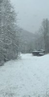
Around a 1 1/2” in north east Macon County this morning. A nice surprise for sure. -
2025-2026 Fall/Winter Mountain Thread
Sw NC weather replied to Buckethead's topic in Southeastern States
Getting a little accumulation down this way. Would be nice to get in on a nice squall overnight and pick up an inch. This flow is setting up nicely some of y’all are gonna rack it up overnight. -
2025-2026 Fall/Winter Mountain Thread
Sw NC weather replied to Buckethead's topic in Southeastern States
We’ve got storms rolling in this morning. Already got some gusty winds down this way. -
2025-2026 Fall/Winter Mountain Thread
Sw NC weather replied to Buckethead's topic in Southeastern States
Congrats everyone. This sure was a fun storm. Bottomed out at -1.2 this morning and just a hair below 7” of snow. -
2025-2026 Fall/Winter Mountain Thread
Sw NC weather replied to Buckethead's topic in Southeastern States
6” here it’s actually picked back up a little bit. Very different totals all around Macon County. All depending on where bands set up. From what I’m seeing I’m around the middle. 4-8” in the county. -
2025-2026 Fall/Winter Mountain Thread
Sw NC weather replied to Buckethead's topic in Southeastern States
Up to 5 1/2”. Last hour and a half has had really tiny flakes and rates have let up. Hoping to get one more good band to get up to 7”. -
2025-2026 Fall/Winter Mountain Thread
Sw NC weather replied to Buckethead's topic in Southeastern States
Over 5” now in northern Macon county. I think we make it to 8 at this rate -
2025-2026 Fall/Winter Mountain Thread
Sw NC weather replied to Buckethead's topic in Southeastern States
Passing 4” now. Straight pounding and appears with snow blowing up on radar pivot should be happening. Long time coming! -
2025-2026 Fall/Winter Mountain Thread
Sw NC weather replied to Buckethead's topic in Southeastern States
That would be additional from 7am on. I don’t think that 2 for Franklin is gonna verify for Franklin. Probably have a 1/2” since 7 and it’s still dumping. Most short range models paint an additional 3-6” for WNC and I don’t think there picking up on the low level rates that we’re getting even. -
2025-2026 Fall/Winter Mountain Thread
Sw NC weather replied to Buckethead's topic in Southeastern States
I noticed that as well. Showing 3 pm or so even down this way but it was late to start. Got 3” already in Northern Macon county. Should be able to get 6”+. -
2025-2026 Fall/Winter Mountain Thread
Sw NC weather replied to Buckethead's topic in Southeastern States
Right at a 1/2” here in northern Macon county. Took a while to get going but should be good for the next 12 hrs or so now. Moderate snow falling at the moment. -
2025-2026 Fall/Winter Mountain Thread
Sw NC weather replied to Buckethead's topic in Southeastern States
Time to enjoy guys. It’s been a long wait for an area wide hit like we’re getting. I’ve got the jack out and the flood light on! -
2025-2026 Fall/Winter Mountain Thread
Sw NC weather replied to Buckethead's topic in Southeastern States
Yes a good 4-8” mountain wide hit is looking likely. Localized higher amounts. -
2025-2026 Fall/Winter Mountain Thread
Sw NC weather replied to Buckethead's topic in Southeastern States
We think the Nam is out to lunch on how it handles the upper level low? It’s been jumping all over the place but still gives me some pause because the 3k dried up down this way some to. -
2025-2026 Fall/Winter Mountain Thread
Sw NC weather replied to Buckethead's topic in Southeastern States
Euro AIFS is a good 5-10” snow for WNC. Regular Euro is similar a smidge east from last run but not bad. -
2025-2026 Fall/Winter Mountain Thread
Sw NC weather replied to Buckethead's topic in Southeastern States
Fv3 also is a nice 4-8” event for us here in the mountains. Seems like a good consensus in those numbers at the moment. -
2025-2026 Fall/Winter Mountain Thread
Sw NC weather replied to Buckethead's topic in Southeastern States
It moved west still some work to do to get to euro but it’s better. I also think there is some feedback issues with it. -
2025-2026 Fall/Winter Mountain Thread
Sw NC weather replied to Buckethead's topic in Southeastern States
Here’s the EPS.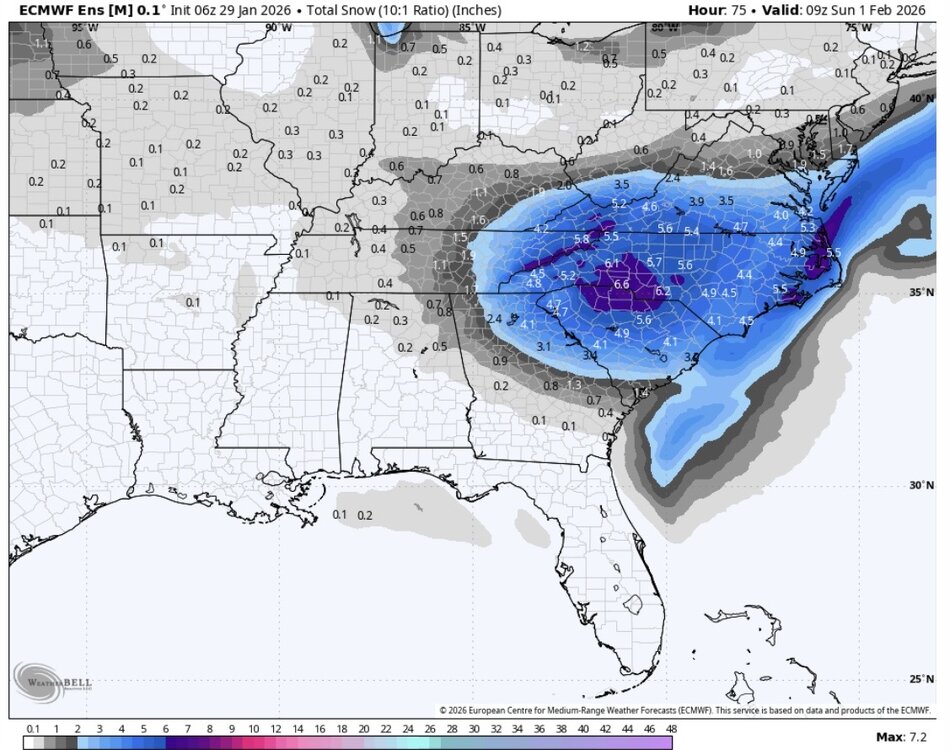
-
2025-2026 Fall/Winter Mountain Thread
Sw NC weather replied to Buckethead's topic in Southeastern States
EPS is a huge uptick. Extrapolating it would be 7-10” with ratios across the mountains. Let’s get the short range models to hone in on this. -
2025-2026 Fall/Winter Mountain Thread
Sw NC weather replied to Buckethead's topic in Southeastern States
It sure would be nice if models started to agree with what the euro just gave us. But you never know with these upper level lows, there will be changes up until go time Friday night. One good thing is ULL always produce localized banding that if you can get under one you will blow by predicted totals. -
2025-2026 Fall/Winter Mountain Thread
Sw NC weather replied to Buckethead's topic in Southeastern States
Even with the “bad” trends today pretty much every model paint 0.3-0.5” of precip which would equate to a great 5-10” snowfall for us. Wouldn’t be surprised to see qpf go up closer to go time with the ULL. -
2025-2026 Fall/Winter Mountain Thread
Sw NC weather replied to Buckethead's topic in Southeastern States
It was gonna crank for another 6-12 hrs as well. Probably would’ve been 8-12” across the mountains. As HVWard said euro ai was a nice 5-8” event as well. -
2025-2026 Fall/Winter Mountain Thread
Sw NC weather replied to Buckethead's topic in Southeastern States
A solid 4-7” thump on the CMC. I think I’m gonna call it a night. Here’s to good trends tonight. -
2025-2026 Fall/Winter Mountain Thread
Sw NC weather replied to Buckethead's topic in Southeastern States
GFS and GFS AI both have 6-16” for the mountains. This is a very tedious setup but there is some very high level boom potential there. Especially if the trend west some more. -
2025-2026 Fall/Winter Mountain Thread
Sw NC weather replied to Buckethead's topic in Southeastern States
The way this thing has trended today. I wouldn’t be surprised for even more than that. But with that in mind it could very well go back the other way. I don’t think we will have to good of a handle on this till Thursday. Fun times of tracking ahead. I think regardless the upper level low will give the mountains a couple of inches.

