

midatlanticweather
-
Posts
4,174 -
Joined
-
Last visited
Content Type
Profiles
Blogs
Forums
American Weather
Media Demo
Store
Gallery
Posts posted by midatlanticweather
-
-
2 minutes ago, Warm Nose said:
Meso discussion from SPC
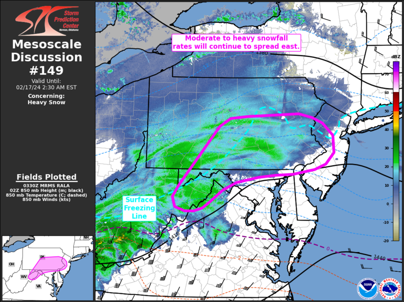
Mesoscale Discussion 0149
   NWS Storm Prediction Center Norman OK
   0933 PM CST Fri Feb 16 2024

   Areas affected...Northeast West Virginia to western New Jersey

   Concerning...Heavy snow

   Valid 170333Z - 170730Z

   SUMMARY...A swath of moderate to heavy snowfall will continue to
   spread east across parts of the Mid-Atlantic over the next several
   hours.

   DISCUSSION...A swath of moderate snowfall continues to spread east
   from the upper OH River Valley region into the Mid-Atlantic based on
   recent regional reflectivity composites. Transient organized snow
   bands continue to be observed within this broader zone, resulting in
   visibility reductions from 1/2 to 1/4 mile and steady snowfall
   accumulations based on recent snow reports from the region.
   Favorable phasing of synoptic ascent ahead of the approaching
   shortwave trough and strong isentropic and frontogenetic lift within
   the 925-700 mb layer, which has been driving this activity so far,
   is expected to persist as the system pushes towards the East Coast
   over the next several hours. Latest forecast guidance depicts
   reasonably high probability in snowfall rates between 1-2 inch/hour
   across portions of the Mid-Atlantic region (and possibly as far east
   as the NJ coast) through 08 UTC. Based on observed trends, this
   depiction seems fairly reasonable. One caveat is a lingering
   warm/dry layer below 850 mb sampled by regional 00 UTC soundings and
   noted in surface observations across northern MD, southeast PA, and
   into western NJ, which may limit snowfall rates in the near term.
   However, a combination of evaporative cooling and persistent
   mesoscale ascent along the warm frontal zone should support adequate
   low-level saturation/cooling to allow for moderate to heavy snowfall
   in the coming hours.
painful reality
-
36.4 with dew point of 21.
-
Currently a warm 48 with a dp of 16. Dry out there but warm
-
This seems to have really shifted. The two maxes still show up. The southern max has come up to just north of DC and the other max is now in Central PA. If we had not started so far south this would have been worse for many! This shift is sad for many in the southern part of the forum.
Maybe it will expand a bit south. 2 to 4/3 to 5 inch seems the best we get with some local lucky folks. Get a little elevation, you may see more. I hope the shifts north and drier trends stop!
-
2 minutes ago, MD Snow said:
The rap and hrrr were giving me 2-8” on Tuesday morning. Got nothing.
.I look at precip output VS. type on theae models. Looking for trends and not exact amounts is the way I treat them.
-
1 minute ago, nw baltimore wx said:
I recall the euro showing a drier run before events in the past. I also recall this guy named Zwyts that would be the voice of reason as the forum went into a meltdown. Point is that I am not too worried about one run of a global this close to game time.
Always stay cautious until you see the snow falling. Never doubt that things can change even when models look good. Any step back from respected models deserves pause. Not saying it is true, but, when in a range of possibilities, you want to be the upper range on models and not the lower ones. Just sayin'
-
 1
1
-
-
-
That looks nice for MBY

-
5
-
 2
2
-
-
HRRR and RAP give me pause with the northward look. I hope we do not see this slip too far north!


-
1
-
-
With the NAM.. my guess is that Blue Ridge parts of the area will get the warning levels. It may be the same elsewhere. If it were a weekday and not the weekend tomorrow, I would think it would be a more widespread warning due to commute impacts. Just me rambling. This looks nice. Loving the FGEN! I would love some thunder. Thinking I take a nap this afternoon so I can be up late!
")
-
2
-
-
-
Oh man! Brutal @Ji - Everyone around Leesburg will get 2 to 3 inches.... but Leesburg gets just 1 to2! LOL!
-
1
-
-
West to east moving systems with dry airmasses get that down sloping dryness! Systems like this then get more moisture as they reached the coast, but the leeward side miss some of the goods! Feels that way many times even in summer, unless the airmass is juicy, storms kind of split for me out here SW of Purcellville. The January 2 snow events did the same for me. Anyways.. ranting about MBY sitting at about 2 inches of snow less from the January storms but getting over an inch yesterday is kind of foolish!
-
2 minutes ago, stormtracker said:
$4,985. per month
This addiction to white powder can be expensive.
-
1
-
 2
2
-
-
39 minutes ago, Eskimo Joe said:
JB says a lot of things.
When JB Talks... Weenies listen.
-
1.7 inches on the cars. About 1.3 on the deck. I am going with 1.3 for this event. Was beautiful coming down. It has come to an end here in Purcellville.
-
1
-
-
Snowing well in Purcellvillle. It was even heavier about 20 minutes ago. Ground is white and the roads have a little slush. Beautiful.. But I am out of the yellow radar bands already.
-
^try Kuchera and I would still think overdone.
Also... HRRRRRRRRRRRR is always a bit pumped! We got Hrrrrrred

-
1
-
-
What the heck is this graphic?
-
The salivating Loudoun Crew.


-
3
-
1
-
-
-
I want to believe, but think this will be the picture early next week! Shoot, this may be too much precipitation as well.

-
3
-
-
16 minutes ago, stormy said:
I'll take this at 270. 3 consecutive runs. At 240 the GFS, ECM and GEM all have the goods brewing in the NW Gulf and S. Texas. It's a SLAM DUNK with all 3 on board at 240. Rather unusual.
You made a classic blunder. The first and most important is to never start a land war in Asia. The second, somewhat less known but equally as important, is never trust weather models showing snow in the Mid Atlantic until you see it on radar at your doorstep or out your window.

-
3
-
-
Hahaha! Bizarre Pivotal snow map!

-
1
-


The Weekend Rule? Saturday 2/17 - The Icon Storm
in Mid Atlantic
Posted
It has been snowing light to moderate. All grass and cars are white. Temp is 32.6 and do of 31. Heavier radar yellows about to come overhead