

SnowGolfBro
-
Posts
1,466 -
Joined
-
Last visited
Content Type
Profiles
Blogs
Forums
American Weather
Media Demo
Store
Gallery
Posts posted by SnowGolfBro
-
-
2 minutes ago, clskinsfan said:
I gotta stay out of the model thread the rest of this event. Downers gonna down. I dont need a model when I am looking at this:

Yea that model thread is a mini panic room right now lol
-
 1
1
-
-
1 minute ago, Bob Chill said:
Wouldn't be surprised if it backs down from 18z. Kinda expecting it. If it backs down from 12z we have reason to complain but if it's still 2-5" the forecast hasnt really changed in days
I mean anything can happen but let’s not let the NAM rain on our parade.
-
28/17 in Montclair. Bright stars with nice cooling going on. Moon shows high clouds streaming this way.
-
7 minutes ago, DCTeacherman said:
Getting close to as @Bob Chill would say “chips fall” time and Euro keeps trending better and better, can’t realky ask for more.
One more 50 mile bump and 6-10 inches forum wide. Let’s bring this S home!
-
3
-
 1
1
-
-
After 0z it’s mostly a gametime thing with a bigger focus on the Mesos
-
1
-
 1
1
-
-
1 minute ago, BristowWx said:
Agree it is. Seems like you wanted that to be true. Congrats.
It’s going to be a gametime decision for who sees the best snow. I like our spot and see that shift as mostly noise
-
1 minute ago, Hyphnx said:
RGEM puts RIC back in play
RGEM paints the whole sub forum with Warning level snow plus. Wow
-
We keep this going up until game time and someone in NOVA could see a lolly of a foot.
-
WWA for the office in Arlington.
WSW for Montclair
-
I wonder if the EPS will show any higher end solutions based on the better look on the OP. Obviously big favor to the Op at such short range, but is their any value in the EPS at this point?
-
Just now, BristowWx said:
That appears to be an acceptable QPF distribution with the maxima in the appropriate and expected location based on the latest meso output.
I like our spot right now. We could end up with 6+ if things break our way and it looks like 2-4 is kind of low end for PWC
-
1 minute ago, WEATHER53 said:
Good looking precip mass.
On radar it looks like it’s really blossoming
-
1 minute ago, GEOS5ftw said:
12z HRDPS is impressive - best stuff stays south of the area but even so, has 4-8 inches with more to come after the run ends.
Is the best stuff in the Richmond to EZF area?
-
5 minutes ago, yoda said:
4 to 6 inches for DC region by 12z Sunday per 12z NAM lol
NAM will be in range by 0z lol
-
Just now, midatlanticweather said:
I hope this is all a trend that ups the ante at noon - we will see watches expand (as we all know - call me mr. obvious) - I like seeing thing trend better.
If the 12z suite looks like 6z I’m pretty sure that WSW will be going up for the DC metro
-
35 minutes ago, losetoa6 said:
Looks like 25mm in DC..wow...if somehow true
Verbatim that gives me closer to 15 inches of snow with 10-1 ratios down in Montclair. Um I’m hugging that S
-
 1
1
-
-
Just now, osfan24 said:
The NAM, woof. And I don't mean DT woofing. It snows for three hours LOL.
Man we went from 30 hours of snow to 3 hours in like 2 days lol
-
1
-
-
20 minutes ago, PCT_ATC said:
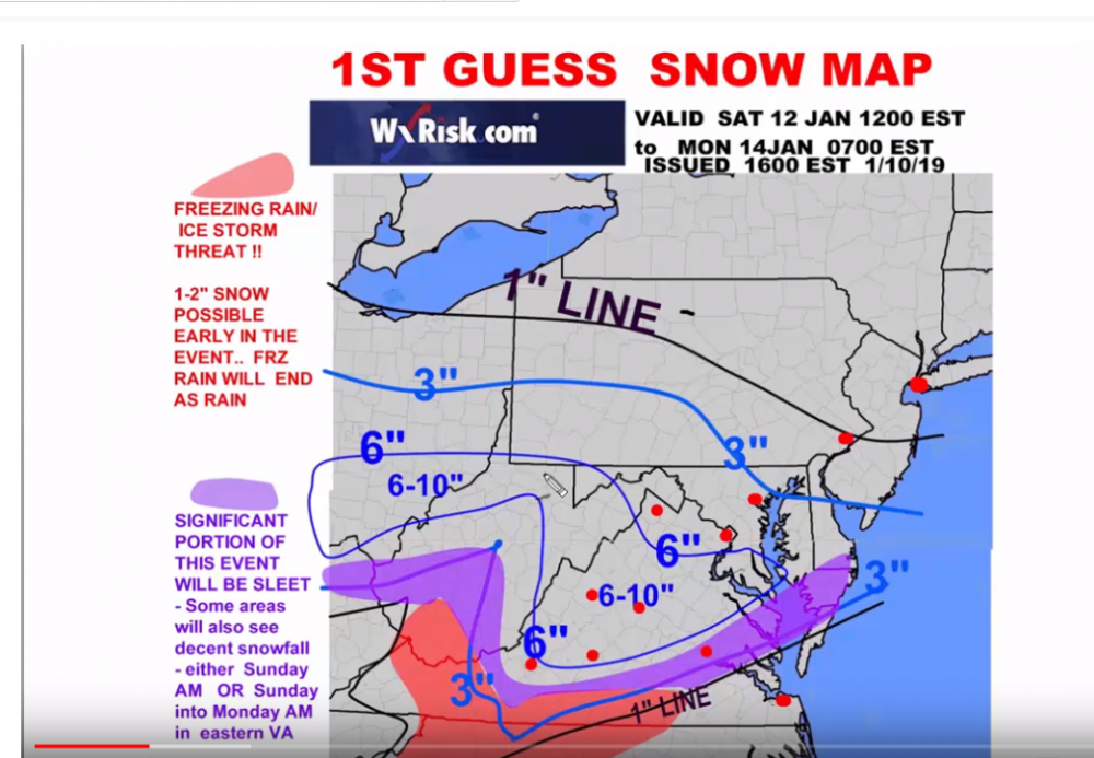 DT's 1st guess map.
And with a 50 mile North trend...
-
1
-
-
4 minutes ago, yoda said:
Agree... I'd subtract 2" from his overall map everywhere... as in 6" line becomes 4" and 4 to 8 is the highest on the map
Wait till he digests the 18z Euro lol
-
Euro is really new at happy hour runs. So not going to let the new dictate things
-
2 minutes ago, psuhoffman said:
With this look you would think "we can't miss" lol

We haven’t gotten desperate yet. If we have to start leaning on the SREFs then we will know we are in trouble

-
5 minutes ago, Chase said:
LWX also modified how they will do the Winter Weather Outlook for the week... interesting dividing lines.
The Shenandoah Valley in me also resents being named the "Piedmont."
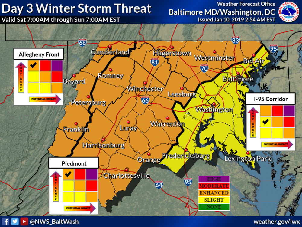
That’s mostly for the WAA. If the coastal were to ramp up close enough to the coast it would be after 7 am Sunday and could be more impactful with less confidence
-
3 minutes ago, wdavis5784 said:
Likewise. We ended up with anywhere between 3-5" in Central Calvert. Literally 15-20 min north and there was nothing.
Right and the jackpot on the models is significantly farther North than the December storm, hence my optimism. Doesn’t mean we can’t get screwed but it’s worth noting that those of us South of DC have a decent shot at a warning event even based on current guidance
-
3
-
-
The Euro looks good for many of us South of DC. Significantly better than any model looked for my area on 12-9. And i scored an inch and people just 25 miles to my South had 4-6 inches. This is still being worked out by the models and even the Northern crew could get in on the good stuff this time.
-
2
-


January 12-14, 2019 Storm Discussion STORM MODE
in Mid Atlantic
Posted
I’m still hoping for a real time 25-50 mile North shift. Partly because it would get me close double digits and partly because it puts the northern tier folks into Warning level snow.