

SnowGolfBro
-
Posts
1,556 -
Joined
-
Last visited
Content Type
Profiles
Blogs
Forums
American Weather
Media Demo
Store
Gallery
Posts posted by SnowGolfBro
-
-
28 minutes ago, Maestrobjwa said:
Nice--That would effectively end the drought, right?
Especially if the late week threat materializes too.
-
 1
1
-
-
Drought busted in Montclair with this latest round.
-
1 hour ago, mdhokie said:
Add in 9am - 1pm Saturday. My kids have had 3 softball rain outs in the first two weeks.
Praying for all windows!
-
 1
1
-
-
5 minutes ago, Eskimo Joe said:
Please just stay dry through tomorrow evening. I have one spot on my deck left to stain. After that it can rain all we want.
I just need dry from 11am - 4pm on Monday. Hopefully we can pull off both windows!
-
1 minute ago, frd said:
Certainly no bowling ball pattern with cold and snow in the East, not sure where that came from because blocking went poof, as soon as it started.
Beyond hour 360 there are signals for impressive warmth in the East while most of the country is cold and stormy. Will not be long for Atlantic feedback loop and the WAR returns. Offshore Atlantic SSTs continue warm.
That sounds great! The sun angle and soil temps in mid March aren’t any good. Plus daylight savings time. Bring on the 70s!
-
Light snow and car topper at the office in Alexandria.
-
5 minutes ago, adelphi_sky said:
Snow shield caving ever so slowly. I think we can get some snow TV at least.
Yep, you can see it on radar. Might not mean much other than mood flakes. But that would be a win at this point lol.
-
1
-
-
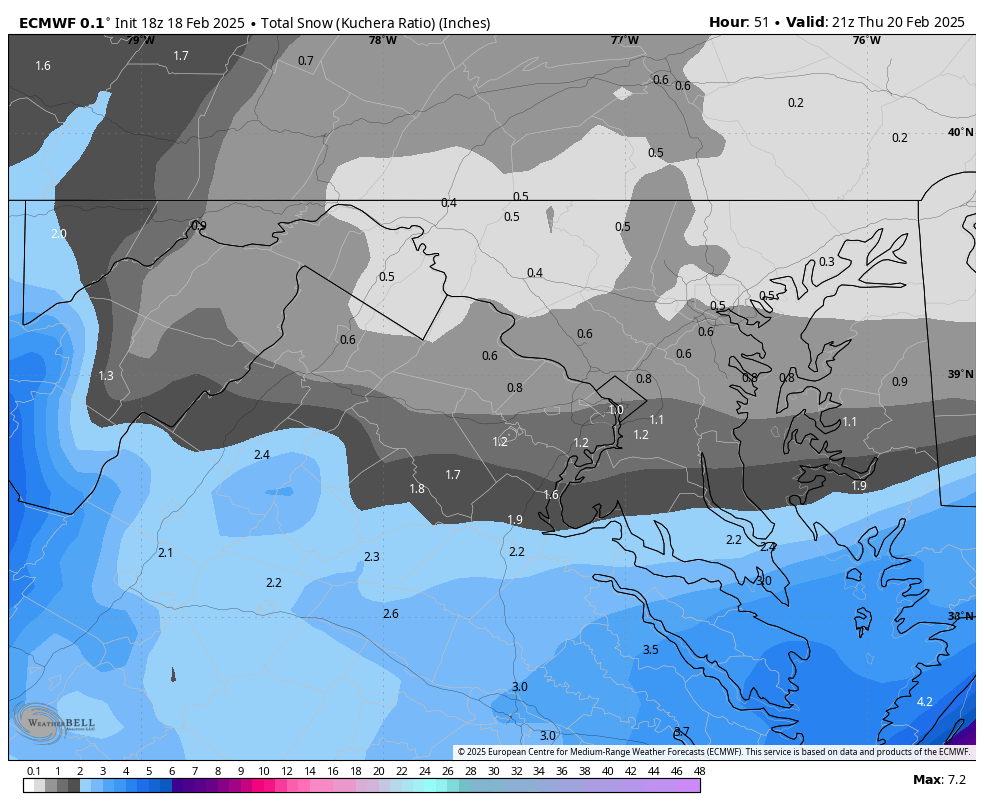
3 minutes ago, NorthArlington101 said:
Between Wednesday and a little Thursday… EURO gets DCA to a Kuchera inch.
 1 minute ago, Solution Man said:
We are so back! 00z will be telling!
-
1
-
3
-
-
1 minute ago, BristowWx said:
Dude I’m telling you this one is gonna surprise us.
At this point it would be a complete surprise. But at least we are playing with house money. Two solid storms already and one that stuck around for basically an entire month.
-
8 minutes ago, Kevin Reilly said:
Boy we’ve come a LONG way since 12z Friday!
If they moved the zones 100 miles south and added a “you’ll get nothing and like it” zone DC north, it wouldn’t be half bad
-
7 minutes ago, LP08 said:
Be easier to do just one color, say 25% and say 0-10
The Washington Post - Snow forecasts Die in Darkness.
-
2
-
-
2 minutes ago, Amped said:
Going to be a fun battle, its the Ecmwf, Gfs. Cmc, rgem, Icon, hrdps, ukmet, fv3 hires, Jma, Navgem and 3km Nam vs the 12km Nam, Brime Trucks and CVS.
Also the highway signs on 95 in VA flashing “winter weather on Wednesday, prepare accordingly”….i don’t think that means what they think it means.
-
3 minutes ago, Solution Man said:
I guess we'll see if the Nam doubles down, or fng with us. Accuweather.com must just use the Nam for short range, its showing 2-4 for mby.
Let’s F Go!
-
1
-
-
6 minutes ago, bncho said:
according to the NAM, DC will get 6 inches of snow.
The NAM looking to go out on top before they take it behind the barn.
-
1
-
-
2 minutes ago, wawarriors4 said:
0.7” would get me to 20” on the season, seems doable around FXBG. I might be baiting myself into this,

I think PWC and more so down your way has a chance to sneak out a 2-4 or 3-6 type deal. It’s going to be plenty cold. So if even .25 -.50 of QPF can find its way to us we can score. Obviously wishcasting that QPF unless you buy the NAM.
-
2
-
-
2 minutes ago, stormtracker said:
We're an odd lot. Just 2 days ago, most here were disappointed and hurt even by 7 sorrowful inches. And now, we'd sacrifice a board member for it.
If the sacrifice would have the desired effect and this were a Democracy, well there would be one less poster on this board come tomorrow lol
-
6 minutes ago, Solution Man said:
Nam is interesting, just doesn’t get past Md line
1 minute ago, Wonderdog said:NAM looks real good. BristowWx, we're back! Solution Man, you do pbp of 18z.
Verbatim on the NAM, a 75 mile NW shift would give PWC a foot plus lol.
-
3 minutes ago, IronTy said:
Was in the locker room after my workout this morning and this one teacher guy was bragging to another dude about how they were probably gonna call off local schools due to 15-18" of snow midweek. The other guy said he just heard a dusting to 2". First guy was in disbelief.
I kept quiet to myself, I imagine sort of like a former POW does when he overhears two guys bellyaching about having to cut their lawns on Saturday.
On Sunday I was talking to the youth director at church. She said we are going to get a big snow on Wednesday. I said I’m not so sure about that. She said it’s guaranteed because Jim Cantore is coming to DC and he’s never wrong. In my mind “you know it’s literally the opposite”, but i just smiled and said “if you say so”.
-
1
-
-
3 minutes ago, SomeguyfromTakomaPark said:
If the models bring this storm back it will be by far the most unhinged thing they’ve ever done.
They would have to update the definition of “windshield wipering”
-
Just now, BristowWx said:
How often does the entire state of VA get snow. Even VA beach. The whole state would be under a watch based on that.
I like our spot! Models are going to bounce around the next 36 hours. But if we are bouncing between 8 inches and 30 inches, i think we settle around 2 feet. But it’s going to be a wild ride to get there lol
-
1
-
-
1 minute ago, Heisy said:

.If what i think happens between frame 1 and frame 2 actually happens, it should be good!
-
1
-
-
Our storm dives into the plains in under 72 hours. Hold strong little roots! LFG!
-
4 minutes ago, clskinsfan said:
Canadian is not over amped. It's perfect.
Just doing a Goldilocks bit. If it went down Canadien style I can dig it! Let’s reel this one in!
-
GFS out to sea, Canadien over amped, so the Euro will be just right. LFG!
-
4
-
June Discobs 2025
in Mid Atlantic
Posted
We were there for the Fathers Day tournament. Called for rain all weekend but we got all the games in! Have a great time!