

SnowGolfBro
-
Posts
1,466 -
Joined
-
Last visited
Content Type
Profiles
Blogs
Forums
American Weather
Media Demo
Store
Gallery
Posts posted by SnowGolfBro
-
-
3 minutes ago, WxUSAF said:
Rabbits will be extinct in SE HoCo if that happens, I promise you.
Starting with the cutest ones
-
4 minutes ago, losetoa6 said:
Hrrrrrrrrrrrrrrrr looks like its turning the corner

Just tug it NW 50-100 miles. Then everybody eats
-
10 minutes ago, snowfan said:
Almost feels dirty posting a long range hrrrrr.

“Storm” done or still going on the HRRRRRRR. Because if we are going to look at the 48 hr HRRRRRR we may as well go the loony bin and extrapolate from there
-
21 minutes ago, LP08 said:
This is a disappointing GIF.

Just need the next 8 runs to go in the opposite direction. We can do this!
-
I feel for the NW crew. 9 winters out of 10 we fight for scraps while you guys rack up totals in marginal setups. Just a weird Nina year i guess. But hoping we can juice up these scraps do everyone gets some action on Sunday
-
 1
1
-
-
-
3 minutes ago, BristowWx said:
my most calculated guess is that you and I and the rest of PWC crew will wake up to wet and brown. it always takes way long to cool down from a previous warm day and we will waste a lot of precip. I can already see the obs Saturday evening of widespread upper 40s that drop painfully slow and settle around 37F. paints a grim pic but you know I am at least half right in this setup.
I’m gonna golf on Saturday and watch snow on Sunday. Self fulfilling prophecy
-
2
-
 1
1
-
-
3 minutes ago, WxUSAF said:
GFS sounding at 6z near DC and MBY (Columbia) is pretty nice. Strong lift maximized in the DGZ. So it may not snow for long, but it might maximize what we get (also falling at night) if the GFS is right.
Give me 1-3 inches in a couple hours and i will stay up and enjoy the show. Take anything we can get at this point. Only a few weeks left before I’m hunting 70s for golf lol
-
7 minutes ago, LeesburgWx said:
Lol, I haven’t dropped the ‘We suck’ comment yet this year…
Lol, yes my list was the family friendly version lol. As time for snow runs shorter the reactions get slightly more violent when we get the rug pulled. Hoping this time we trend into a solid storm!
-
1
-
-
Just now, LeesburgWx said:
I fully expect the GFS to hold here at 18z. It’s been pretty locked in now for 3-4 consecutive runs. It is in it’s King wheelhouse. Just need that bullseye stripe to come north 30-40 miles.
Or juice up the current stripe so as to include Leesburg in the 6-10 range. of course these are the type of comments that precede the following comments:
next
wide right
wheres the storm
might need a human sacrifice
-
1
-
-
1 minute ago, Ji said:
usually when you take blends--you end up getting nothing
Touché. I just hope this trends like January 3rd and i get a foot. Also rooting for the NW crew, but typical backyard sport disclaimer applies.
-
I’ll take a blend of the GFS, Euro and Canadian for the win.
-
Front pushing through Montclair now. Went from 56 to 45 in about an hour. Colder rain!
-
2 minutes ago, chris21 said:
Euro still made a significant shift south. At this point, that's all I'm looking for.
The difference between the Euro and the GFS has a significant effect on precip type for our area. But at this range the difference is not more than noise. If the models show this divergence on Wednesday then the forecast becomes a challenge. What else is new lol
-
1
-
-
Flurries in Montclair! It’s on!
-
Hoping to get first flakes before the inevitable “here comes the back edge” posts
-
3 minutes ago, osfan24 said:
Just saw that Mike Masco video. Loved the line "it's just a matter of if Baltimore and DC are surprised with 6 inches or 10 inches."
This guy is a real meteorologist. On TV.
He’d fit right in here lol
-
2
-
1
-
-
4 minutes ago, The Ole Bucket said:
That will be their first last call map.
-
1
-
-
5 minutes ago, Cobalt said:
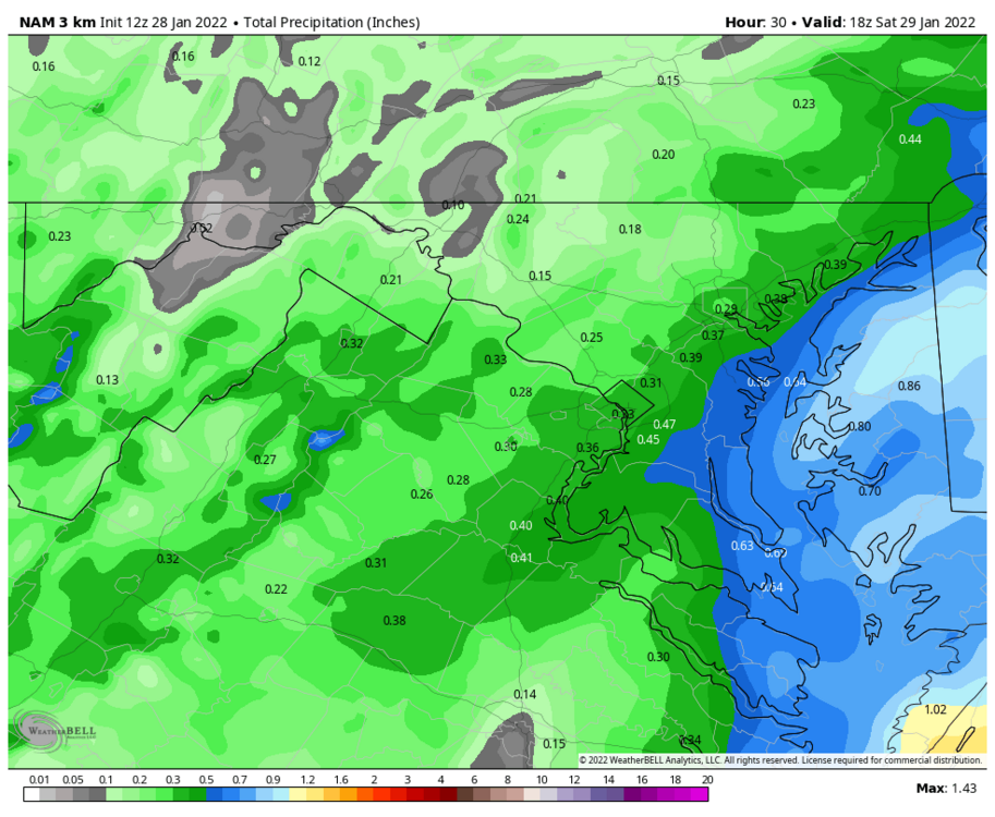
3k NAM
Move that little blue finger 25 miles west and it’s on
-
1
-
-
Sun is poking through. Perhaps it will destabilize the atmosphere. Loving the pics from the great dusted north!
-
9 minutes ago, Ji said:14 minutes ago, SnowGolfBro said:watched Sue Palka at 10. It’s a nothing burger. Turned on Bob Ryan at 11. Get out your shovels. Foot plus with drifts the next morning. I will never forget that
No sue caught it first. Went from flurries to 2-5
That’s fair. But everyone who went to bed before the 11pm news was in utter shock the next morning. At no point would i ever disrespect Sue.
Edit so we just need to get this one to 2–5 by 10pm tomorrow and it’s on
-
4 minutes ago, yoda said:
It is just after 22 years to the day... maybe...

watched Sue Palka at 10. It’s a nothing burger. Turned on Bob Ryan at 11. Get out your shovels. Foot plus with drifts the next morning. I will never forget that
-
1
-
-
3 minutes ago, Solution Man said:
 Sterling:
&& .NEAR TERM /UNTIL 6 AM FRIDAY MORNING/... High pressure will slide offshore tonight. The combination of high cloudsincreasing overnight and a light south flow to start the night should keep low temperatures a bit milder in a relative sense when compared to this morning. A leading atmospheric disturbance ahead of a larger system developing over the central U.S. will likelydeliver some snow shower activity along and west of the Allegheny Front tonight, with generally a coating to an inch or two expected. && .SHORT TERM /6 AM FRIDAY MORNING THROUGH SATURDAY NIGHT/... Guidance this evening has trended a little northwest. In addition to this, we are now entering the within 24-hour window for the entire area. Therefore, nudged snowfall up a little from what was inherited and added winter weather advisories across our eastern zones, primarily near and east of I-95. These may need to be expanded into the metro proper given snowfall starting near rush hour and the very low rush-hour criteria over the metro, but will leave that decision to later shifts. Also want to watch guidance trends to see where things land as far as 0Z model shifts.
Sterling:
&& .NEAR TERM /UNTIL 6 AM FRIDAY MORNING/... High pressure will slide offshore tonight. The combination of high cloudsincreasing overnight and a light south flow to start the night should keep low temperatures a bit milder in a relative sense when compared to this morning. A leading atmospheric disturbance ahead of a larger system developing over the central U.S. will likelydeliver some snow shower activity along and west of the Allegheny Front tonight, with generally a coating to an inch or two expected. && .SHORT TERM /6 AM FRIDAY MORNING THROUGH SATURDAY NIGHT/... Guidance this evening has trended a little northwest. In addition to this, we are now entering the within 24-hour window for the entire area. Therefore, nudged snowfall up a little from what was inherited and added winter weather advisories across our eastern zones, primarily near and east of I-95. These may need to be expanded into the metro proper given snowfall starting near rush hour and the very low rush-hour criteria over the metro, but will leave that decision to later shifts. Also want to watch guidance trends to see where things land as far as 0Z model shifts.Could have summed it up with “we just can’t know”
-
1
-
1
-
-
1 minute ago, WinterWxLuvr said:
Here’s my shot at a post that may not age well … betcha all of the 0z runs up precip totals across the board.
Can we ingest this data into the 0z models?!
-
2
-


Feb 12/13 Event Quest for Blues to Envelop More Rather Than Less
in Mid Atlantic
Posted
18z Euro = we toss