PB COLTS NECK NJ
-
Posts
458 -
Joined
-
Last visited
Content Type
Profiles
Blogs
Forums
American Weather
Media Demo
Store
Gallery
Everything posted by PB COLTS NECK NJ
-
January 30, 2019 Snow Squall Observations Thread
PB COLTS NECK NJ replied to bluewave's topic in New York City Metro
The skill is not in the snow maps. -
January 30, 2019 Snow Squall Observations Thread
PB COLTS NECK NJ replied to bluewave's topic in New York City Metro
The EPS looks good , it`s cold with some very deep members -
January 30, 2019 Snow Squall Observations Thread
PB COLTS NECK NJ replied to bluewave's topic in New York City Metro
The cold is here , but is it cold either side of what I think is a big storm is a valid question. It would be a dagger if the 15 days were well BN and you phased a moisture laden storm off the E/C and the coastal plain surged for 12 hours. Long ways off tho. -
January 30, 2019 Snow Squall Observations Thread
PB COLTS NECK NJ replied to bluewave's topic in New York City Metro
I love Grand Planetary waves but we will need some luck to keep the coast all snow. I would like to see the ridge axis to be a little further east here so I can keep the center off A/C , but check out the moisture feed for this one as well. Big ticket storm for someone.
-
January 2019 General Discussion & Observations
PB COLTS NECK NJ replied to Rtd208's topic in New York City Metro
Pattern looks great now , you are going to snow Friday morning , N and W of NYC are going to get a nice snow and sleet storm on Sunday before we at the coast rain , then you`re going to 10 degrees Monday morning with the 6 to 10 , not just the 11 to 15 looking cold. Do not give up on the 24/25 , that`s got a chance in this pattern. -
January 2019 General Discussion & Observations
PB COLTS NECK NJ replied to Rtd208's topic in New York City Metro
oh boy man , that`s not arguing or angry in the least. You said you get it upset , I stated I couldn`t be happier the way things are evolving. Have a great day bro. -
January 2019 General Discussion & Observations
PB COLTS NECK NJ replied to Rtd208's topic in New York City Metro
Chris , all due respect , my start date after seeing the DEC warm up has been Jan 10. Brian will attest that I def saw the warm up starting on Dec 13 and actually bet that those following 20 days were going to be 60 % AN , I lost to someone who`s forecast was 80 %. But I was AN. Then I have been adamant about my period beginning on Jan 10th ( that went off without a hitch ) and lasting thru Feb 20. I posted in here 2 weeks ago that the coldest anomalies were going to occur during the coldest part of the winter, honestly I could not be happier with the idea. My point about the MJO and how some in here are looking at it is it will be muted. I am looking at the overall pattern and not just 1 system. You are going to snow on Friday morning with the same p4 that`s going to make it rain for a while on Sunday. P4 - P5 have ridging thru the lakes and on into the SE. That`s not what`s coming . It gets thwarted by the blocking that going to take place as the strat has worked it`s way down. You already have a TPV in HB that will be forcing the trough through the lakes into the midsection and on east , completely opposite of what p4- p5 - p6 does. I am saying that the MJO effects are muted in Jan and will not in any way mimic what you saw in December. Too many gauge the pattern by their backyard , I think you will see the MJO muted here. -
January 2019 General Discussion & Observations
PB COLTS NECK NJ replied to Rtd208's topic in New York City Metro
You responded to my post to Brian and Snoski who looked at the RIMM plots and decided to punt Jan. You then said the MJO has an " effect " here, in this case it`s 12 hours worth. The rest of period both before and after have no SE ridge that one would associate with a p4 or p5. I illustrated how the MJO in 4 - 5 will have minimal effect on the pattern. Maybe that will clear it up. -
January 2019 General Discussion & Observations
PB COLTS NECK NJ replied to Rtd208's topic in New York City Metro
Here is p4 and p5 You will be in p4 and p 5 in the 6 to 10 Here are your 2m in the 6 - 10 Do you not see that the MJO is being overridden ? -
January 2019 General Discussion & Observations
PB COLTS NECK NJ replied to Rtd208's topic in New York City Metro
That`s day 6 - 10 . The pattern flipped on the 10th evident by everyday since then being BN. The only subtle shift I see now is the 1 to 2 inch coast , 2 to 4 inch snow that falls by Friday morning. That was not seen 5 days ago. Followed by some front end snow and Ice a flip to rain and temps to 10 degrees 12 hours later. What you will find is that very cold anomalies are going to set in well before the MJO gets back to 7 / 8. That is because it`s being muted this time. -
January 2019 General Discussion & Observations
PB COLTS NECK NJ replied to Rtd208's topic in New York City Metro
And look at it`s old 11 -15 And it`s new 6 to 10 Look at the new depth of the trough. And it`s response regardless of the MJO phase here. The SSW effects will be felt in the pattern and will mitigate the MJO. -
January 2019 General Discussion & Observations
PB COLTS NECK NJ replied to Rtd208's topic in New York City Metro
This is what is going to push the pattern , Go take a look at where the AO is headed as this is propagating down. You guys are looking in the wrong direction and think a 1 off system and a 12 hour spike in temps is mitigating what is coming -
January 2019 General Discussion & Observations
PB COLTS NECK NJ replied to Rtd208's topic in New York City Metro
You can look at the CFS / WEEKLIES / EPS / GEFS or the GFS operational and you are going to see the same 500 emerging -
January 2019 General Discussion & Observations
PB COLTS NECK NJ replied to Rtd208's topic in New York City Metro
There is no SE ridge , it`s a Western Atlantic Ridge and there`s a 12 hour warm up before the dam breaks. The pull back is the EPO pops + and that`s why the trough is pulled back. The large scale hemispheric pattern is forecast to be night day from the mid to late DEC period. The MJO can fly around the RIMM plots all they want the rest of the month , the impact will be minimal at best as you have a TPV sitting over you through the end of the month. -
January 2019 General Discussion & Observations
PB COLTS NECK NJ replied to Rtd208's topic in New York City Metro
Hopefully now you guys can stop with the dumb RIMM plots. griteater @griteater FollowFollow @griteater More From NOAA's latest Weekly MJO Update... -
January 2019 General Discussion & Observations
PB COLTS NECK NJ replied to Rtd208's topic in New York City Metro
BTW day 10 EPS now has this As does the GEFS I know some of you saw the GFS 2m anomaly map and decided to air mail winter in , but this will likely have a better air mass in front of it as well as a - EPO this time ( this weekend the EPO pops + ) . Some of you need to relax , you have no idea what`s coming over the next 30 days do you ? -
January 2019 General Discussion & Observations
PB COLTS NECK NJ replied to Rtd208's topic in New York City Metro
-
January 2019 General Discussion & Observations
PB COLTS NECK NJ replied to Rtd208's topic in New York City Metro
Probably , but since the 10th , we are BN and will stay BN the rest of the month when you average it all out. There is too much weight put on the MJO in here for the last 10 days of the month. We are not torching like we did in Dec. -
January 2019 General Discussion & Observations
PB COLTS NECK NJ replied to Rtd208's topic in New York City Metro
You are not going to get the same response this month. -
January 2019 General Discussion & Observations
PB COLTS NECK NJ replied to Rtd208's topic in New York City Metro
The warm up you see this weekend is about 18 hours long. The anomaly for the day is positive but the cold air rushes right back in. The MJO is not going to give you the same warm response in late Jan that it did in Dec. You are going to get 3 to 4 days of cold and 1 day cutter and than back to cold. Not to mention that you will snow Thrs nite into Friday morning. You now have TPV sitting over H/B , the MJO will have to fight with that. That was not present in Dec. -
The EURO / RGEM / NAM like it , I think it comes thru the flow ok.
-
BTW some of you will have snow on the ground come Friday morning. The Euro has it even though the NAM is at the end of it`s envelope it`s prob right , but I like this before the Sun / Mon debacle.
-
The EPS at 2m You can pull up all 15 days on the EPS at 12z and you will see the following 1 -2 -3 - 7- 8- 9 - 12 - 13 - 14 - 15 very cold and BN 4 - 5- 6 10 -11 , the EPS has 2 cutter in here and they are AN . Those 2 cutter skew the period but count , otherwise the source region has changed and you will see that when you total up the 15 days . I get it if you don`t snow , nothing`s changed but according to energy traders what`s coming is being viewed as big deal.
-
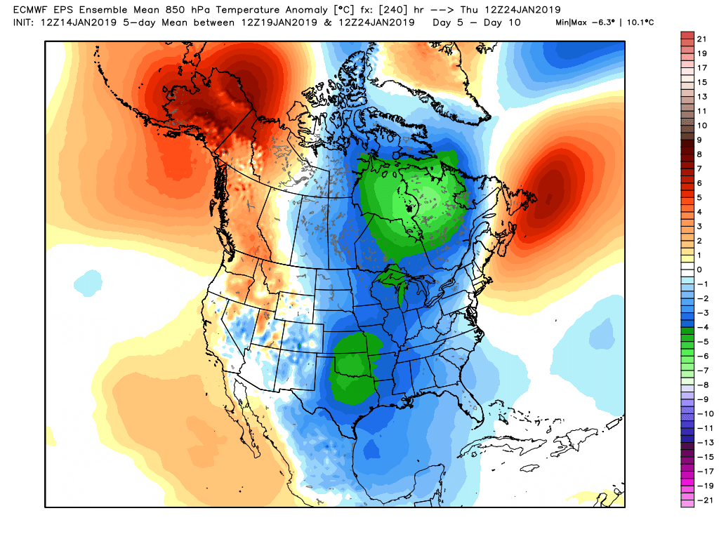
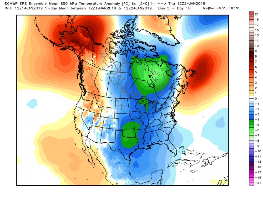
1st of all they are not AN , second , you don`t know how to use " 850 anomalies " in mid Jan. If your N 850 on Jan 20 is - 8 and LP comes through , your 850`s can be - 1 ( A PLUS 7 ANOMALY ) and the surface would be 30 with a snowstorm. Stop using 850 anomalies in here in the heart of winter , low level 2 meter temps determine if you are AN or BN. To your 1st point , here`s day 5 -10 which includes a cutter. So it`s cold before and very cold after.
-
Not what you said ..... You said there was a " big SE ridge and a trough in the west on the EPS in the long range " , was that just your opinion ?