

OrdIowPitMsp
-
Posts
1,908 -
Joined
-
Last visited
Content Type
Profiles
Blogs
Forums
American Weather
Media Demo
Store
Gallery
Posts posted by OrdIowPitMsp
-
-
Tomorrow will be the 8th consecutive day above 90 in Minneapolis.
It’s been 15 years since a streak that long and never this early in June.
-
Surprise thundershower giving the lawn and garden a much appreciated drink. It’s completely sunny out and pouring.
-
43 minutes ago, Brian D said:
Lake Superior is calling you. It's actually feels chilly here with the stiff Lake wind.
") Around 65-70 here in town.
Around 65-70 here in town.
Might have to take a day trip up there this weekend. We were camping near Hovland over Memorial Day weekend, the late freeze meant remarkably zero bugs, and a low of 37 while we were there.
”Only” got up to 95 today.
-
Overachieving high of 97 at MSP.
Overnight low was 77.
-
10:40pm and still 88 out. This heat is getting insane just like my electric bill will soon be.
-
“Only” made it up to 93 yesterday. Euro has 90s here through next Monday which would be 12 consecutive days. The lows staying above 75 is insult to injury for my poor garden.
-
 1
1
-
-
At 10:40 we are still sitting at 90 degrees.
-
Appears we will be 99’d in MSP today. 5min obs been stuck there since 120pm
-
Record high of 97 in MSP today. Could make a run at 100 tomorrow. Crispy out there.
-
0.21” of rain yesterday with backend flurries this morning. Tomorrow we should bag our first 70 of the year.
-
Lake Nokomis a few blocks from my house is now officially ice free. The median date of ice out is April 4th, so a couple weeks early this year.
-
1
-
-
Urban lakes are still holding their ice but with 1” of rain coming tomorrow through Wednesday I imagine ice-out will be occurring very soon here.
-
0.3” of wet slush this morning. 7am snow depth of 3” should be all but gone by the end of the week.
-
-
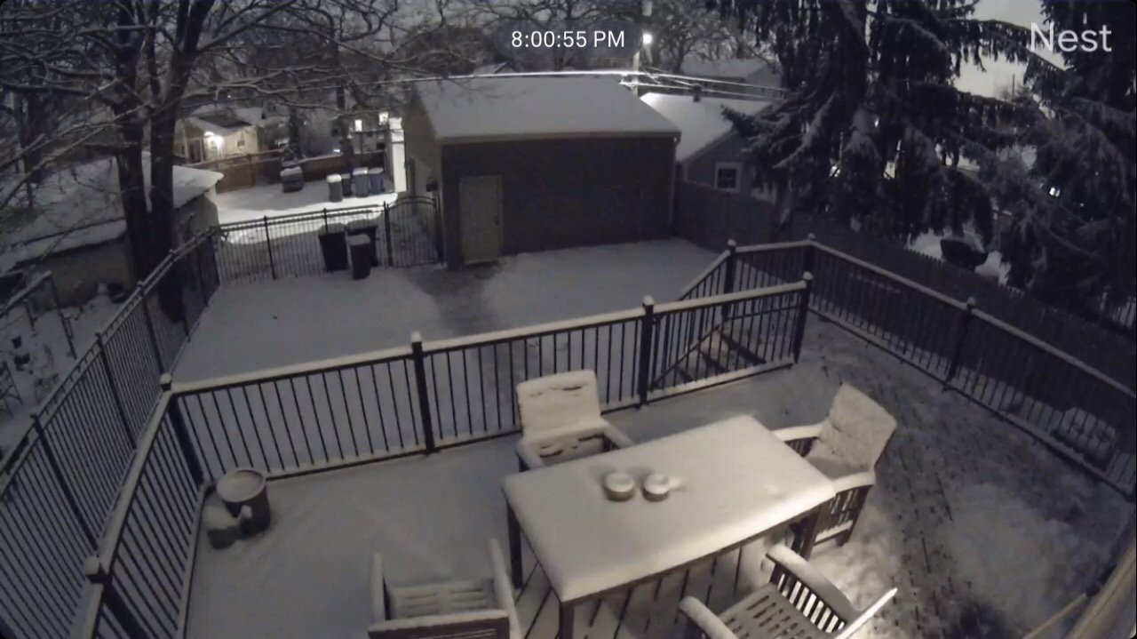
Just measured 3.5" here with snow about finishing up. Storm ended up a bit further NE then modeled putting down 2-5" across the metro, with double digit amounts across southern Minnesota based on reports. Classic spring wet slop, although the top inch is much drier.
-
1
-
-
Straight dumping heavy snow here right now. Solid 1.5” down on the far west side of Bloomington. Going to be an impressive spread of totals across the metro area.
-
2-3” in the forecast for mby. With the snow falling during the day I have a hard time believing rates will be strong enough to efficiently accumulate.
-
Springtime brings out all sorts of different weather warnings.
-
3
-
-
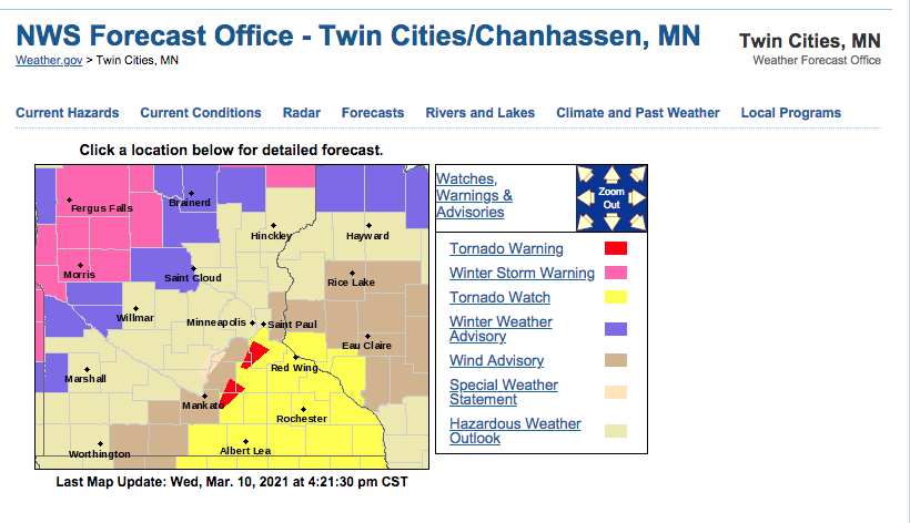
First Tor warning of the year for this area.
QuoteTornado Warning
Tornado Warning MNC037-131-139-102245- /O.NEW.KMPX.TO.W.0001.210310T2213Z-210310T2245Z/ BULLETIN - EAS ACTIVATION REQUESTED Tornado Warning National Weather Service Twin Cities/Chanhassen MN 413 PM CST Wed Mar 10 2021 The National Weather Service in the Twin Cities has issued a * Tornado Warning for... Southwestern Dakota County in east central Minnesota... Southeastern Scott County in east central Minnesota... North central Rice County in south central Minnesota... * Until 445 PM CST. * At 413 PM CST, a severe thunderstorm capable of producing a tornado was located over Webster, or 10 miles west of Northfield, moving northeast at 45 mph. HAZARD...Tornado. SOURCE...Radar indicated rotation. IMPACT...Flying debris will be dangerous to those caught without shelter. Mobile homes will be damaged or destroyed. Damage to roofs, windows, and vehicles will occur. Tree damage is likely. * This dangerous storm will be near... Lakeville and Farmington around 435 PM CST. Apple Valley around 440 PM CST. Rosemount around 445 PM CST. Other locations impacted by this tornadic thunderstorm include Castle Rock and Lakeville Airport. PRECAUTIONARY/PREPAREDNESS ACTIONS... TAKE COVER NOW! Move to a basement or an interior room on the lowest floor of a sturdy building. Avoid windows. If you are outdoors, in a mobile home, or in a vehicle, move to the closest substantial shelter and protect yourself from flying debris. && LAT...LON 4445 9335 4448 9343 4477 9325 4467 9300 TIME...MOT...LOC 2213Z 207DEG 38KT 4450 9336 TORNADO...RADAR INDICATED HAIL...<.75IN $$ ETA -
So close yet so far....

-
43 at noon, steady light rain with a few heavier bursts this morning. Hate to see the snow vanish but nice to wash all of the crude off the roads.
-
First lightning flash of the year here. Meanwhile @Brian D and the arrowhead region of Minnesota are in line for 4-8” of snow. Must be spring.
-
2
-
-
High of 63 today breaks the record of 61 from all the way back in 1879.
-
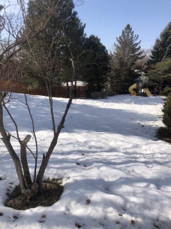
58 and full sun today. Official snowdepth at the airport is T, but out in the suburbs the snow is hanging on at the in-laws backyard.
-
1
-

June 2021 General Discussion
in Lakes/Ohio Valley
Posted
97 here today. Felt the symptoms of heat exhaustion/something worse at work today. Stopped sweating, pounding headache, nauseous, and the occasional hot breeze actually gave me chills.
Still at a cool 88 at 10:45pm. The insanity continues.