

kvegas-wx
-
Posts
2,073 -
Joined
-
Last visited
Content Type
Profiles
Blogs
Forums
American Weather
Media Demo
Store
Gallery
Posts posted by kvegas-wx
-
-
I predict this storm may just bust a nut all over southern wake county. Should be ample coverage for those folks.
-
 2
2
-
-
I was so trying to avoid this place. It feels kinda ookie in here. Like a bunch of people in VA had nightmares about suppression and collectively sweat the bed. I need a shower.....
-
13 minutes ago, CAD_Wedge_NC said:
Then I can't explain why it would show "sleet and snow" with that sounding.
Absolutely fascinating and quite honestly, I learned something valuable. Made the last 5 days of sleep deprivation and storm prep all worth it!
Belated thanks Isohume!
-
4 minutes ago, wncsnow said:

Ouch. NAM says I can use a shovel instead of a blower after all. About a third of the FV3 total!
-
Just now, WeatherNC said:
How is that a SN & IP best guess, unless I forgot to read Skew-T's that's SN, likely heavy.
Beat me to it. And you read them a lot more than I do. But I cant see sleet in that??
-
4 minutes ago, BornAgain13 said:
Deep Thunder Model
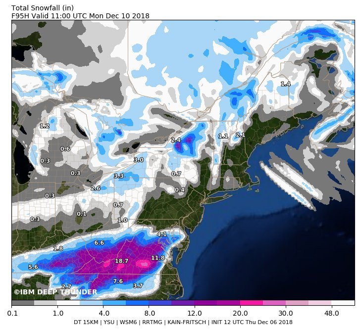
I keep seeing this model tossed into the discussion. I think it has been around since the mid 90's but is it still considered experimental? Is it private B2B subscription model? Just wondering with over 20 years of data and tweaking, who is actually using it?
-
If the storm plays out as modeled I think we'll all be surprised, yet happy. But if things take a dramatic turn, the post mortem on this one is going to be an incredible read.
-
 4
4
-
-
1 minute ago, SLAMSTORM22 said:
New to the forum... Is GSO Greensboro?
Welcome! Yep. INT is winston salem. RDU is raleigh. CLT is Charlotte.
-
8 minutes ago, CADEffect said:
Thanks CAD. May your user name be the talk of the town this weekend!
-
1
-
1
-
-
As models like the RGEM and HRRR enter the discussion this weekend, we should have models to look at every couple hours or so tomorrow and Saturday. Does anyone have an old post, or maybe a current summary available that lists the model run times for all models?
-
3 minutes ago, Queencitywx said:
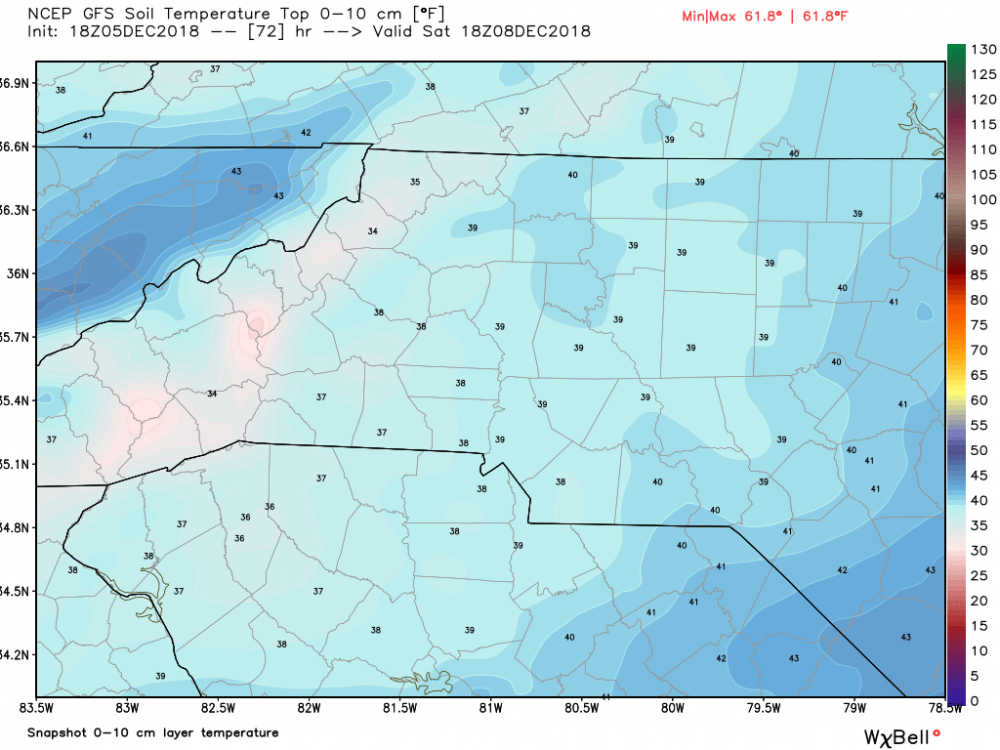
Oh yeah, we're so gonna crush those grounds temps, and quickly! So remove ground temps from your winter storm reasons for failure checklist. It's gonna accumulate no problem.
-
Knowing the ground wont get any warmer over the next couple of days, anyone have a hotlink to a soil temp map? We're certainly not frozen, but we arent in the upper 40s either. Rates will easily overcome current conditions. (Crystal clear tonight in the triad. Cold already!)
-
2 minutes ago, NCSU_Pi said:
Guys, I hate to ask a MBY post when you're likely in storm mode, but I beg a special dispensation: I'm flying back to RDU late Saturday night, and I would like to hear about the timing. I have a very inconsistent internet connection here, and many common sources of information, like Twitter, are blocked by the Great Firewall.
How likely is an impact by Saturday night? Not just in terms of getting on the ground, but also getting home from the airport. I know I could probably read back some pages, but I don't have a whole lot of time, and I'm worried I may lose my connection at any moment.
Thanks, and please have mercy, mods.
Sunday start for the potential heavy stuff. Should be fine in Ral for saturday night as it stands now.
-
 1
1
-
-
Just now, lilj4425 said:
What in the...???

Maybe a 3 way call with proper introductions? Do these guys even know each other? Maybe an annual holiday party or something? Good grief!
-
2
-
3
-
-
The HP is weaker and north, the LP is north by quite a bit too. Eagerly awaiting another EURO run now. I feel as if the lug nuts are getting loose.
-
1
-
 1
1
-
-
Good for the mountain communities today, that's gonna be a heckuva lot more than an inch or two for Boone at those rates. A hot streak in December for the ski resorts!
Educational question - what model(s) are incorporated into the Bufkit product? Just one run or multiple runs? Curious how frequently those get updated and if we get a drastic shift in the models in the next day or two, if the shift will be as equally drastic in the Bufkit product or if it will be averaged out over time?
-
1
-
-
So even with some positive Euro totals overnight, it started to waffle around with phasing and bringing the whole system north. Now I see my forecast for the triad has gone to three straight days of freezing rain in the Triad. 3 days!! I really hope that we arent on a razers edge with strong CAD, a crappy storm track and a month of power outages. But I am afraid somebody, more likely south of me, should be investing in a generator.
On a brighter note, FV3 says calm down Euro.
-
Just now, Orangeburgwx said:
Dude you have no chance. Clearly it is time for a snow chase. Pack it up!
-
1
-
2
-
7
-
1
-
-
Lanie Pope goes with a 10-30% chance of accumulating snow over the WXII coverage area. Last time I checked their coverage area includes a few tall thingies called mountains!?! She may want to update that slightly for the 11pm broadcast.
-
4
-
2
-
-
57 minutes ago, Orangeburgwx said:
EURO Master with 41.9" in Lake Lure...
Can you share this?
-
So if we on the east coast rely on systems to come on shore before they can be sampled, and then we have 2-3 days to fine tune the forecast, do the people on the west coast think they are waking up to sunny and 75 and suddenly its raining?? Seriously, how does it work on the west coast for forecasting if upper air features can't be sampled until they are on shore? Seems almost paradoxical.
-
11 hours ago, Shack said:
Maybe I missed something somewhere, but where is Brick?
Hangs out mostly on another WX board but he stalks around here as well.
-
I see today is the day that begins a new stage of grief as we are now moving from "bargaining" to "depression" once the reality begins to set in. Happens every storm without fail. Don't worry, "acceptance" of your fate is a mere 72 hours away! (accept for Mack, he's already moved on to his first January storm)

-
3
-
-
If anyone has any ointment, you might want to start looking for flies. Climo says no, history says no. I wont bet against those two ever when something this unprecedented comes along.
We dont get historic, Sierra Nevada snows in December with marginal temps, 48 hour duration and uncannily perfect timing of two systems. It just.doesnt.happen.
So where's that fly?
-
3
-

December 8-10, 2018 Winter Storm
in Southeastern States
Posted
Huh?? Lucy got some splainin' to do. Image?