

Thinksnow18
-
Posts
4,144 -
Joined
-
Last visited
Content Type
Profiles
Blogs
Forums
American Weather
Media Demo
Store
Gallery
Posts posted by Thinksnow18
-
-
23 minutes ago, Leelee said:
Don't these secondary coastal lows usually take more moisture from the primary than models suggest though? That seems like what KBUF discussion has been suggesting the last few days kind of downplaying what models are showing.
Depends on the transfer. If the primary holds on longer then no. Not surprisingly the models are struggling with this.
-
2 minutes ago, wolfie09 said:
.png.b140a9d1d904325af18300c42f700340.png)
.png.49d97ce4d0dcf8ab21fafc569262558e.png)
Everyone wins with panel 18
-
 1
1
-
-
1 minute ago, BuffaloWeather said:
I would say south central NY. I don't think it makes it as far north as SYR, but the last few runs get it close.
Wow dude get out of my brain…

-
16 minutes ago, BuffaloWeather said:
Might be a dry slot somewhere when that secondary takes over.
Yeah I’m thinking the central southern tier towards Binghamton. WNY as Devin posted looks 6-10” with enhancement and ratios.
-
1 hour ago, wolfie09 said:
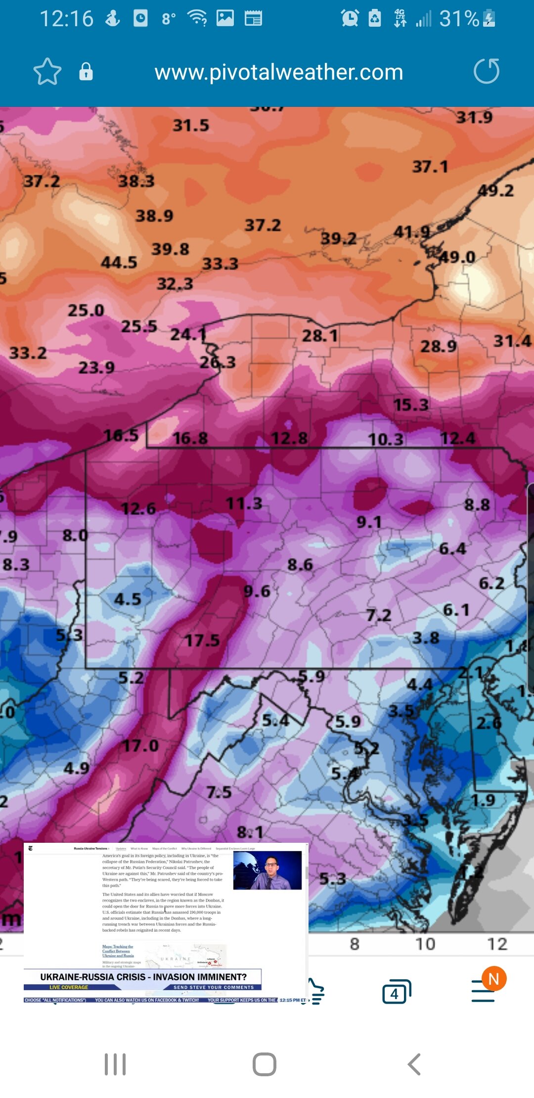
..Winter Headlines Possible Thursday Night through Friday...

Thursday will be mainly dry as a light northerly wind persists
across the region. Flow in the mid-levels becomes southerly and warm
air advection begins from south to north across the region Thursday.
Temperatures remain cold at the surface with highs in the low to mid
20s and low 30s across the far western Southern Tier. The pattern
becomes amplified Thursday night as a shortwave trough tracks across
the Plains. A dual upper level jet structure will aide in further
development of surface low pressure over the central/southern
Appalachians while a secondary low forms off the east coast late
Thursday night. Increasing moisture will occur across New York State
while warm air advection increases. A widespread snow fall will move
into western NY late Thursday evening and become widespread across
western NY overnight. Snow will likely reach the North Country late
Thursday night. As warm air continues to surge northward 850mb
temperatures will approach 0C across the far western Southern Tier
by Friday morning. The primary surface low will move into western
Pennsylvania while the 850mb low is over Lake Erie. There might be a
window of a few hours that mixed precipitation moves into locations
near the NY/PA border Friday morning. For Thursday night, a
widespread 1-3 inches of snow is possible across the North Country
to the Finger Lakes and Niagara Frontier and 2-5 inches south in the
western Southern Tier Thursday night. Lower confidence in snow
totals across the western Southern Tier due to the chance of a
changeover to a wintry mix. More precipitation expected into Friday,
see below.

The approaching shortwave trough will move overhead Friday while the
primary surface low over western Pennsylvania phases rapidly with
the coastal low. An intensifying upper level jet over northern New
England and phasing surface lows will shift deeper moisture and
large scale ascent rapidly to the coast. Snow will continue Friday
as an easterly moisture fetch persists across the region. Cold air
will wrap around the surface low resulting in lake enhancement by
Friday afternoon into Friday evening. Any chance of a wintry mix
across the western Southern Tier Friday morning will quickly end as
cold air moves into the region later Friday. Additional snowfall
accumulation of a few inches is possible Friday-Friday evening.
Winter Weather Headlines are possible from Thursday night through
Friday night. Temperatures will reach the 20s across most of the
region Friday with some low to mid 30s near the NY/PA border. Cold,
Friday night with temperatures in the single digits across the
region.

Lake effect snow will continue on the backside of this system
Saturday and Saturday night. Snow showers will likely start south-
southeast of the Lakes Saturday and move northward into Saturday
night. Another shortwave trough may move into the Great Lakes Sunday
into Monday resulting in another chance for snow showers across the
region
I’d like to say I’ve never seen the NWS so confused but I’d be lying…
-
 2
2
-
-
Just now, BuffaloWeather said:
Weak Miller B with thermal issues, this thing has lots of issues, going low on totals for WNY.
I see why it’s been quiet on here now…
-
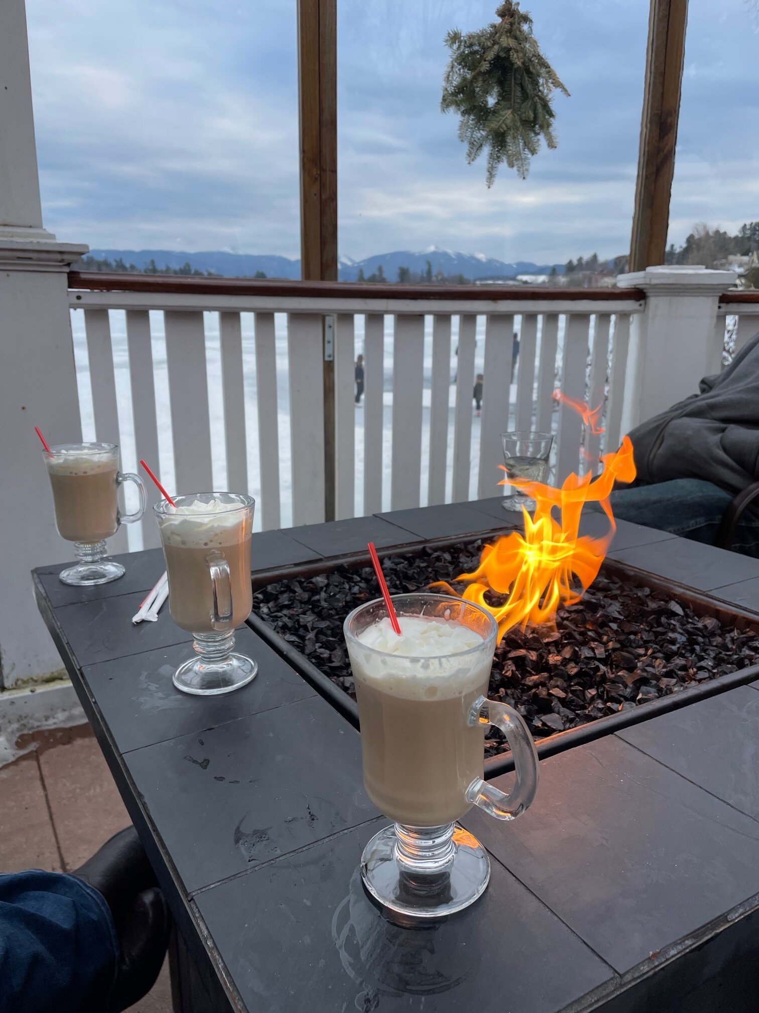
5 minutes ago, Buffalo Bumble said:
Coffee and Bailey’s on the deck at The Cottage in Lake Placid…mild here too.

Way to rub that in BW…
-
1
-
-
34 minutes ago, tim123 said:
Sure does look wintry over next 2 weeks.

Lots of love
-
13 minutes ago, wolfie09 said:
While the mean looks solid on the eps , still a decent spread amongst members which is to be expected, obviously lol
Some are south, some are north and you get the mean lol Big difference between a couple inches and double digits..
Wolfie you’re the guru of NWS text posts…any idea where/why the NWS stated a lull in precip for Thursday night??? Do they have a secret model or are they just losing it???
-
1 hour ago, rochesterdave said:
I really like the chance for enhancement with this storm. Long duration of ENE winds. Something to watch for.

Which if you look at the LR globals they all show the Niagara Frontier with the least amount of QPF…this SHOULD be the exact opposite with those wind trajectories
-
1
-
-
14 minutes ago, tombo82685 said:
Agreed, March sun angle is that of September. You can definitely notice the difference big time that snow struggles to accumulate unless it’s snowing at a good clip
Oddly I’ve always felt March was October, April was September, may was August and June and July were on their own.
-
1 hour ago, sferic said:
Hey Guys,
Ho w does it look Wednesday if I'd like to make a day trip with my family to Niagara Falls from Cicero?
Clear sailing back and forth?
Wet
-
1
-
-
15 minutes ago, SouthBuffaloSteve said:
Yeah they really should have issued a warning for Buffalo area. I was down there waiting to intercept it and it caught me off guard, only image people out driving unaware.
Somewhere Jim Cantore just shouted and he doesn’t know why…
-
2
-
-
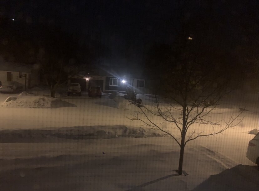
True whiteout with the frontal passage. Can’t see across street. Insane.
-
2
-
-
30 minutes ago, TugHillMatt said:
Shocking. How many times have we seen that the past several winters?!? A Low over Jamestown and the bloody #$@#$@$#@$@#!@!@#@!#! bulge of warmth/mix right up Saharasizzlecuse's anus.
Exactly what is that word???
-
2
-
-
GFS has been fairly consistent in showing that system for late next week as a cold one with lots of moisture. I have to believe this COULD be a pretty big system in terms of accumulation, one where even Matt could enjoy in on the fun…maybe…
-
1
-
-
3 hours ago, lakeeffectkid383 said:
Snow pack held on no problem here. Still at least 6” of pack. Huge difference between my place and my work in Hamburg with much more snow otg here. Must have been that extra lake effect event where I got over 14” in between synoptic storms that really helped because the difference between here and Hamburg is unreal for such a short distance. Snowing nicely out now.
Never officially lost my pack in Williamsville either, about 3” we’re left in the yard picked up about 4” over night and snowing lightly ATM.
-
11 minutes ago, tombo82685 said:
Could it be for ice the warning?
It’s a combination. .10” accretion and 4-7”.
-
2
-
-
1 minute ago, tombo82685 said:
i'll go for an inch for lville with this system of snow/sleet total
I’m backing off in the amounts in Northern Erie as well, 1-3” tops. At this point I also don’t believe Niagara or Orleans counties receive warning level snows.
-
22 minutes ago, rochesterdave said:
39F with a stiff north breeze. Sad. Lol
I’m in North Tonawanda and it’s 33
-
1
-
-
4 minutes ago, SouthBuffaloSteve said:
Caz looks like it has been fully blown out now. Buffalo River on the other hand has a major jam in place from Smith Street back to the area behind Tesla. Two additional jams are lurking just upstream into Kaiser Town area. Could be some flooding problems down in the First Ward tonight if these start shifting.
Had a birdseye view from my truck today while in the 90. That area of the Buffalo River was jammed with ice throughout and the water level was no more than 2-3 feet from the bottom of the Harlem Rd bridge.
-
22 minutes ago, BuffaloWeather said:
I'll be driving the 90 into the tug on Saturday. Going to plan it out so I get in the best stuff.

Only the people on this blog pull for treacherous conditions while traveling…
-
2
-
-
8 minutes ago, vortmax said:
Interesting:
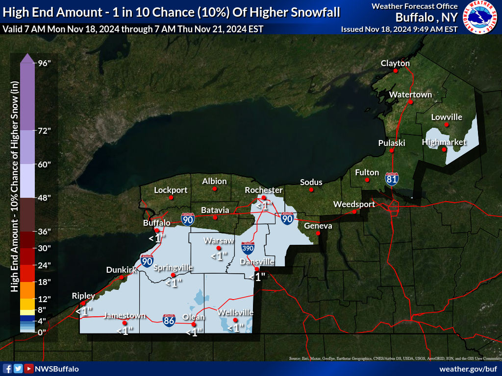
KBUF down to 36. I think that high end amount has a 70% chance of occurring. That lines up almost identical to the GFS has been showing for about 36 hours now. Williamsville down to 35…we’re right there
-
1
-
-
Temp down to 37 already in Williamsville. Things are ahead of schedule IMO
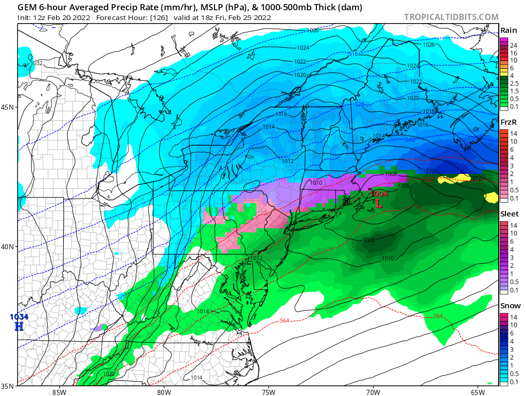
Potential of Widespread Snow/ Mixed Precipitation 2/25
in Upstate New York/Pennsylvania
Posted
Ahhh but it does show quite a bit of enhancement which I believe will play out, and really the Euro is in its own at this point