

Thinksnow18
-
Posts
4,144 -
Joined
-
Last visited
Content Type
Profiles
Blogs
Forums
American Weather
Media Demo
Store
Gallery
Posts posted by Thinksnow18
-
-
22 minutes ago, BuffaloWeather said:
Feb Stats:
BUF: +2.1
ROC: -1.3
WAT: +0.2
SYR: +2.3
BING: +0.7Huh
-
1 hour ago, BuffaloWeather said:


With that look getting to average at KBUF might be in jeopardy
-
Lake Erie looks to be getting its act together again.
-
12 minutes ago, wolfie09 said:
Southwest flow continuing tonight ahead of an approaching arctic
boundary. This will continue to keep the potential for accumulating
lake snows east of Lake Ontario. Depth of synoptic moisture
increases and improves the potential for accumulations which will
last into Sunday, as the arctic boundary drops through. Several
inches of snow is certainly possible especially on the Tug Hill.

Conditions to look favorable for the development snow squalls on
Sunday, especially during the afternoon as the arctic front presses
through. A 45-50 knot low level jet will be passing overhead,
bringing the potential for gusty winds. Any snow squalls will move
southeast along and behind the front, with briefly intense snowfall
rates around 1"/hr and gusts up to 45 mph. Any wet roadways will
freeze quickly as temperatures plummet behind the boundary.
Strong cold air advection continues behind a cold front Sunday night. Lake effect snow showers will develop south of the Lakes as flow veers from west-northwest to northwest. Conditions improve for lake effect snow south of Lake Ontario as 850mb temperatures fall to -18C and inversion heights become 5-6k feet. The RGEM suggests the Genesee Valley to the Finger Lakes as the most favorable spot for minor accumulations into Monday morning. Cold Sunday night with temperatures in the single digits across western NY to the minus single digits east of Lake Ontario.
Notice no mention of Lake Erie??? All need a new profession.
-
 1
1
-
-
1 minute ago, BuffaloWeather said:
2.5" so far today and moderate snow. Looks like band is going to begin to move north again as winds are predominantly SW/WSW.
Yes that band out over the southern Niagara peninsula is beelining fir northern Erie…
-
47 minutes ago, ayuud11 said:
Damm beautiful out there was this forecasted? That thing is ripping gotta be close to 2-3/hr stuff in Cheektowaga.
Always love an Ayuud post
-
Still heavy snow in Williamsville and yes a definite shift to the south soon…but it might oscillate around a bit later today and tonight. Winds don’t veer until tomorrow so someone or several of us might be in for a surprise.
-
 2
2
-
-
Heavy snow in Williamsville. Roads have caved less than 1/4 visibility. Special weather statement coming soon?
-
2 minutes ago, lakeeffectkid383 said:
Nope and I think all the models are overdoing the ice coverage on Lake Erie. What ice there is isn’t even solid and can still transport moisture through it. I had a job yesterday in Angola right on the lake in a 3 story house on top of a dune and could see out into the lake pretty far when it wasn’t snowing and there’s tons of open water as far as I could see past the first mile or so out which was ice but could still see slush and open pockets of water in that.
Agreed. Every satellite pic of Lake Erie have shown great open areas on the East end and slush ice in the central basin. Snowing moderately here now as well and this could surprise.
-
A little Lake Erie surprise this afternoon for Buffalo???
-
14 minutes ago, lakeeffectkid383 said:
Looks like freezing rain here right now. 21 degrees. Freezing rain even up in Niagara County. Radar returns are weak as heck. Just eyeballing out the window looks like between 1-2 inches of snow/sleet. Weak sauce.
congrats to those getting pounded!
Same 1” tops. This system never got its act together. Exit stage left.
-
 1
1
-
-
So…I’m throwing out the “B” word and it’s not blizzard…
-
1
-
1
-
-
20 minutes ago, PerintonMan said:
Syracuse at nearly half of their usual is nuts. Albany well below half. Binghamton down almost 40% too. This should at least let ENY cash in pretty well.
Only BUF-ROC close to average.
I mean we’re kind of above at KBUF…put down the sharpened spoon Matt…
-
2
-
-
20 minutes ago, BuffaloWeather said:
moisture starved system

I think I’ve kinda said that since this afternoon…it looks terrible on radar
-
1
-
-
Anyone else still thinks this system looks unorganized???
-
Does anyone else think this system looks terribly unorganized???
-
10 minutes ago, lakeeffectkid383 said:
I’d take a 6” snowfall here and run. Nervous as hell about the mix line but we are pretty far west so idk what to think.
I mean if we want the best snows we gotta sniff the…yeah we know the rest…
-
Looks like the NE forum have all begun the

-
1
-
-
49 minutes ago, wolfie09 said:
Lies haha
Just like other NWS offices, they sit outside the city and away from the immediate lake shore..
WFO Marquette currently is situated eight miles west of downtown Marquette in Negaunee Township. The area is hilly, forested, and rises abruptly by over 750 feet above the Lake Superior shoreline eight miles to the east

Erie rings a bell…
-
1
-
-
1 hour ago, BuffaloWeather said:
That is odd they’re predicting 8-12” from eastern Erie/Niagara eastward but no watch…
-
36 minutes ago, BGM Blizzard said:
18z Euro a smidge north of 12z.
.thumb.png.07b9bbe0e4ac3f363e928e0102a40540.png)
.thumb.png.70e101cfdec0810a99184ac9fd39718f.png)
So I take umbrage with the Euro. It’s south of the other models which means the warm air tongue isn’t in play which means a colder overall solution .4 at KBUF but 4”? 10-1? Toss. It would equate with ratios of 15-1 to 7”.
-
3 minutes ago, wolfie09 said:
Damn you PW..


I do believe 6-10” is the WNY/Niagara Frontier area. Southern tier is a bit less due to sleet. Enhancement will play a key role from 90 corridor north to Lake Ontario.
-
1
-
-
40 minutes ago, TugHillMatt said:
It's not often Binghamton goes bigger than Buffalo.
Give it time
-
2
-
-
6 minutes ago, BGM Blizzard said:
18z NBM... widespread 6-9 locally higher in ENY
.thumb.png.bad638e527e1aafc0abb69f52b0dad2b.png)
And that’s at 10:1
-
1
-

.png.8a345ad95c7ebaedb4c810c00e6e3670.png)

.png.17e83883b310cd16af60b5855209a807.png)


.png.3056cac73516fe4870e5e5805a9b6479.png)
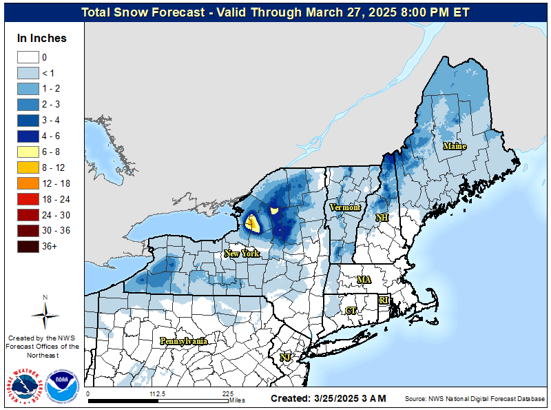
Upstate/Eastern New York-Pattern Change Vs Tughill Curse?
in Upstate New York/Pennsylvania
Posted
No I know. Just wondering how rich is 3 degrees colder just 60 miles to our NE.