

Waiting on snow
-
Posts
406 -
Joined
-
Last visited
Content Type
Profiles
Blogs
Forums
American Weather
Media Demo
Store
Gallery
Posts posted by Waiting on snow
-
-
The NAO is the cause for epic shit patterns lately. Sure it can snow without it. Hell it's had to for a decade now. 09-10 and the front half of 10-11 had great blocking. Looking back it's obvious you need the NAO to score big snow and sustained cold here. The late 70s is another example. Sure a NAO can cause a storm to amplify and pull north. 09-10 had many near misses to the north. A good Pac is more important to get the cold yes, but the NAO is cherry on top and helps it not be such a thread the needle event. I find it hard to believe Greenland is melting when theres always a massive ****ing blue ball of low heights parked over it all damn winter every year!
-
 1
1
-
-
7 minutes ago, ryan1234 said:
Hey, at least a lot of you have gotten a little something and it looks like some of you are further southwest will get a little something. Charlotte is literally in a screw zone, or at least it has been for the last 5 winters. Haven’t really gotten a decent amount since 2014. It’s really getting old.
.
It's been a very rough stretch from Atlanta up to Charlotte. And even worse for Athens to Columbia. Hell this whole decade has been shit for the most part except for 10-11 and 13-14 for those areas. I've come to expect it in this day and age. Sad times for snow lovers.
-
 1
1
-
-
14 hours ago, Iceagewhereartthou said:
We're living in the WRONG place my friend, we can't even get fantasy snow right now!

This will go down as memorable winter alright. It'll be the one with hype and expectations that literally found every way possible to fail us.
-
24 minutes ago, NCSNOW said:
Why are yall sweating LR? Got 3 shots this week. Longest one is sunday night into monday and mainly down east. Artic front again is long shot, but euro is right we can squeeze out .2 if that little wave will develop on tail end. Then next weekend as of now looks great overrunner for almost whole region. May , should have a few more shots post Feb 10 till March.
If we can squeeze out something next weekend I personally wouldn't care what it does LR. But we still have to get half this board some snow since they're still snowless. And some areas very snow starved. So I do pay attention long range and hopefully even if we screw up next weekend there will still be shots.
-
13 minutes ago, CaryWx said:
Also noticed the 06z GFS keeps cold in place until around 2/8 so week after next may not be so bad.
I don't know. Until the ensembles respond call me skeptical. They could be wrong. Just the other day they looked good. But its concerning that while they show cold periodically, they quickly lose it and an awful Pacific is the most consistent thing showing. As of now the long range looks awful and anyone trying to find good in it is trying to polish a turd. Just my opinion though.
-
I hate winter! I hate summer! I hate cold! I hate heat!
But me likey snow!

-
1
-
-
6 minutes ago, Holston_River_Rambler said:
#Grumpycat
Hello! You rang?
-
1
-
-
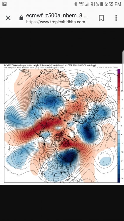
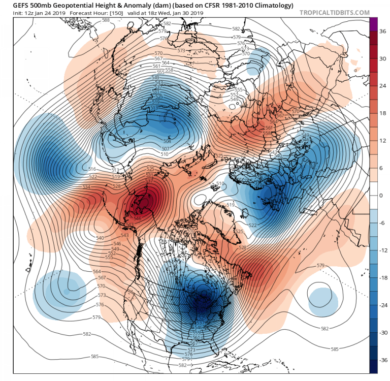
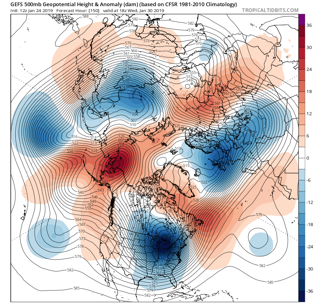
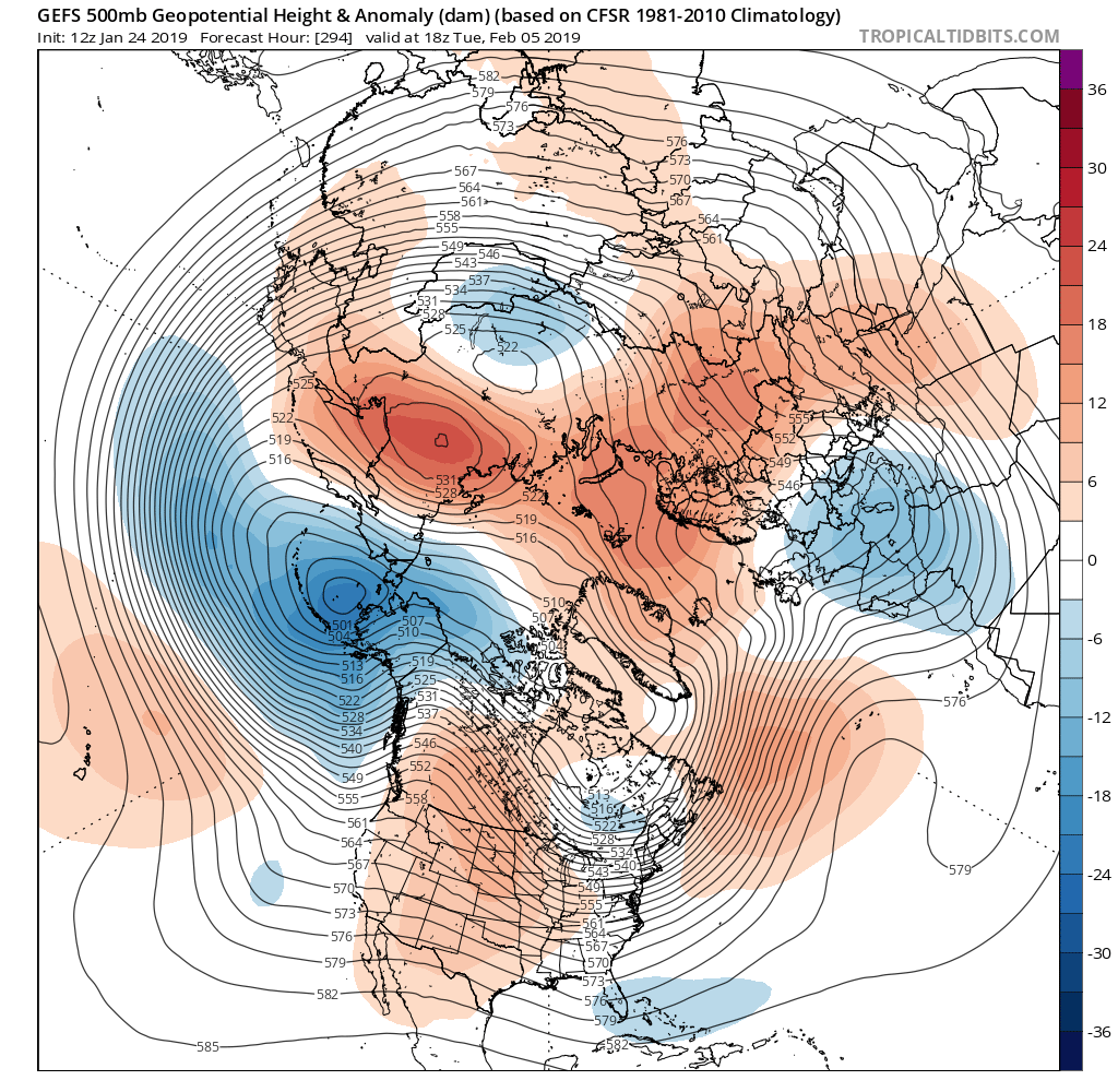
This is a good look leading up to Feb 2nd. The PV lobe is rotating ne and getting close to the 50/50 location. West coast ridge is right on the coast. Great look and seems like a very legit window.
-
1
-
-
It's clear why this pattern sucks. West coast ridge is too far west and the war is forcing cutters.
Next week I'd say is chasing unicorns with a piece of the PV over Chicago. Flat and suppressed and relying on fropa.
Last image, don't pay attention to the colors. West ridge is further east, war is weaker and maybe more toward NAO domain. Maybe split flow? The first week of Feb looks the best to score imo.

-
1
-
-
4 minutes ago, FallsLake said:
Nope, and the Canadian went down as well.
But on the positive side, the Canadian does have a nice storm showing in the 8/9 day range.............................................................................

-
Oh boy!! Another Arctic airmass next week that that will surely flush snow chances down the shitter again. What a pattern!!
-
25 minutes ago, southernskimmer said:
Before we take you back to your regularly scheduled programming, we have a developing story in the newsroom. Watch as the disco thread goes from sanitarium to obs and banter. More on this at 10.
Don't worry. At the 11 news when the 0z models roll it'll be back to the sanitarium.
-
 1
1
-
-
I guess I'll hang out in here and chase a pattern that I'll most likely fail with down here, regardless if its epic or not!!
-
32 minutes ago, kvegas-wx said:
If we don't get a whiff of snow before month end, or have a very solid event to track the first week of Feb this board is going to come unglued. Nerves are frayed! We should install a countdown clock on the main thread page so everyone has to watch the seconds of winter tick away with no snow. We should also post discount codes for online therapy sessions. I think some folks in SC are going to need some professional help soon. Lol!
I just need some dry. I mean a long ass period of dry. I have so many outdoor construction projects to finish that I couldn't do last year, I could be happy with a month of dry. Sure, I'd love one last snow before March, but outside of that bring me 50's and sunny please!
It's already an epic meltdown. Me included! It stems from all the hype this winter brought. Not blaming anyone, everyone though it would be great. And when the December storm came it looked like the hype would verify.
Now here we sit about to hit Feb and the end is closely approaching, and we've had nothing since and are chasing 288 hrs GFS unicorns! All while half the board is completely snowless and even some areas hit in December are still below average and nothing promising going forward. What an epic winter! Only epic winter we will ever see is some fluke in a strong La Nina year that absolutely nobody sees coming.
-
40 minutes ago, Billypg70 said:
I've been following you and others on this board for probably more than a decade.
I couldn't agree more with your last 2 posts.
I get so sick about hearing how we can't get snow because of a lack of -NAO.
Even years we have had -NAO's & other indices in favorable positions.
We still depend upon timing.
I understand there's certain ppl on this board who I respect or enjoy seeing their posts who are 20 to 50 miles off from nothing to literally 6" or more.
Mack lives within 30 minutes or so of me.
The last 3 storms he has gotten either flurries or nothing while I had 3" December 17, 4" January 18, & 6" inches in December 18.
That has to be frustrating as hell.
I feel for him and others on this board.
The last time I remember a board covering snow was middle Feb 14.
We have plenty of time regardless of modeling.
Also models are tools.
You guys know you can't take each model verbatim.
I seen someone talking about how spot on they were for the last few weeks.
I disagree,
Just 3 days ago I was supposed to be mid to upper 50's today.
I have not been above 43 today.
That's a bust to me.
Listen to guys who know what their talking about.
I still believe we will have a pretty big storm or 2 that covers most of the board.
Probably not all but,
If you live in coastal areas or the Midlands you really shouldn't expect a winter storm but every 5 to 8 years.
I agree about the NAO. It's been absent for close to a decade and things still work out. It can actually hurt you with southern energy though, slowing it, letting it amplify and riding north. In this pattern it would do wonders though. It could slow down this northern stream crap and allow it to amplify instead of being a strung out mess. But it's a unicorn and still is this winter too unfortunately.
As far as the Midlands that's not true at all. At least the northern Midlands. I grew up in Newberry and never went more than 2 years without measurable snow. Maybe Orangeburg and places south are every 5 years or so. But lately Newberry hasn't had snow since 14 and even the southern Upstate hasn't. That area between 85 and 20 has really gotten the short end of the stick. It's pathetic! If any area is due its them! Even if I got clouds and they got snow it wouldn't bother me none.
-
1
-
-
14 minutes ago, Cold Rain said:
I don't see how we can say definitively things are shot for the next two weeks when there is a good deal of cold nearby and a lot of energy in the flow. That doesn't make sense to me. I agree that this isn't a blockbuster winter pattern, but winter weather has been found in more hostile patterns types than this.
Yeah it's probably not a complete shutout pattern. But once it relaxes is when I'd expect a shot. Until the end of the month I'd say the coastal areas have a better shot of a late bloomer that inland areas. The EPS generally keeps the ridge out west and trough in the east all the way through now. But we really need the STJ to crank back up because depending on the northern stream is just asking for disappointment. Lol
-
32 minutes ago, oconeexman said:
Safe to say January is shot along with the first of Feburary. Gives most of us about a 4 week window realistically for snow chances.
It's shot because this northern stream dominated pattern is almost as bad as being flooded with Pacific zonal flow. Unless you like freezing with no snow this pattern isn't for you. I can't wait until it breaks down. My opinion that's when we'll maybe see a realistic shot. Let's just hope we don't go to zonal again once it does. I'm fine with the trough moving to the west for a bit even if it pumps a SE ridge. That's something to easily get out of with just minor work. Zonal flow again in Feb you can shut the blinds.
-
7 minutes ago, Queencitywx said:
I am sick to goddamned death of banter and whining in the disco thread.
If these epic patterns didn't always turn into a suck fest and we actually could get a legit threat it may not be that way. Just saying...
-
1
-
-
I see a lot of people saying that the models are struggling. I don't see that. Outside 7-8 days yes. Inside that they seem good to me. The 20th storm, this current storm were all modeled to be a cutter a week out. That's exactly what happened. The weekend threat inside 7 days has been constantly suppressed and that's the very likely outcome as well. Next week is up in the air but as we close in on the 7 day mark and models are basically starting to show a fropa, I'd keep my expectations very low for that as well. Just stating how I see it.
-
5 minutes ago, Queencitywx said:
Arctic front with backside snow showers this run.
Figures. That always works out so well!
-
1
-
-
35 minutes ago, Orangeburgwx said:
Weather channel a week from today:
Cloudy with rain and snow showers in the evening. Snow showers overnight. Low 28F. Winds NW at 5 to 10 mph. Chance of precip 50%. About one inch of snow expected
Did you really just post an automated forecast from a weather app a week out?

-
3
-
 1
1
-
5
-
1
-
-
27 minutes ago, WidreMann said:
DRY.
Warm and wet or cold and dry. That's the pattern down here all winter, every winter, except for about once or twice a year when the stars align.
-
1
-
-
Even with all the energy diving down bouncing around and threats showing up, I think I'll hang in here where I belong.
-
1
-
-
1 hour ago, griteater said:
I'm struck by how the 500mb pattern manages to be super suppressive with the backside waves diving into the trough, yet not overly cold at the same time
Just proves we really can always find new and improved ways to fail.


Southeast Sanitarium - A Place to Vent
in Southeastern States
Posted
I've given up on next weekend at this point. It's still a threat I guess but I'm tired of wasting energy to end up failing. The cold air looks to be on afterburners out of here next weekend so the threat has decreased significantly imo. I'm ready for spring now. I'm very disappointed in this winter, but hell that's normal 9 of 10 winters anyway.