

Waiting on snow
-
Posts
406 -
Joined
-
Last visited
Content Type
Profiles
Blogs
Forums
American Weather
Media Demo
Store
Gallery
Posts posted by Waiting on snow
-
-
7 minutes ago, eyewall said:
And nobody wanted to take my word for it
I knew in December January was toast. Now it looks like February is too. I can't believe the GSP to RDU corridor may get skunked completely. I'd give that an 80% chance of happening right now. But I'm not surprised with today's climate.
-
 1
1
-
-
1 hour ago, LithiaWx said:
Feb isn’t a bad climo month.
Those days are over! Last 4 have been basically spring months. And this one will make 5.
-
 1
1
-
 1
1
-
 1
1
-
-
1 minute ago, mackerel_sky said:
NW trend
That doesn't apply when it's a good thing.
-
 2
2
-
-
Nobody really thought all that moisture was going to hang around once it got cold did they? That's not how this works. Colder drier air holds less moisture. Give me a 0.5 to 0.75 inches of liquid and cold and call it a day. Theres a reason 1-2 foot snows are so rare down here. A 6 inch storm is great down here.
-
9 minutes ago, Orangeburgwx said:
Lots of areas got nailed with WAA due to the low making landfall in Charleston and hightailing it up through Eastern NC... Here is the clown map


Sent from my LML212VL using Tapatalk
So let me get this straight. The low is off the coast and moves back over land in Charleston and moves due noth from there?
-
1 hour ago, mackerel_sky said:
Ok, game on! 6z GFS has a signal around the 22nd or so, looks a lot like CMC run, just more suppressed, but plenty of cold air!
Game on until Wxsouth starts hyping and it's all over then!
-
1
-
1
-
1
-
-
25 minutes ago, Orangeburgwx said:
18z suites took a big hit
Sent from my LML212VL using Tapatalk
My money is on panel 17 being closest to reality. We've seen this movie way too many times and should know the ending.
-
2
-
-
I don't take these op runs literally. But that's 3 in a row of crap. Can't help but wonder if the wheels are wobbling a little now and its only a matter of time before the ensembles push the pattern change back too.
-
1
-
-
1 hour ago, Orangeburgwx said:
This from hr240? Or did it get even better in the 11-15 day range?

Sent from my LML212VL using Tapatalk
Very similar to that.
-
1
-
-
8 minutes ago, Orangeburgwx said:
6z EPS or the one from last night? Cause I nearly cried when I saw that look on the 0z
Sent from my LML212VL using Tapatalk
The 0z ensembles. I cant get the image to load for some reason. Has huge -EPO with split flow and even a hint of a -NAO.
-
12 minutes ago, Orangeburgwx said:
It is a blip, 6z GEFS hr312

Sent from my LML212VL using Tapatalk
Yeah I know. Just talking junk to Mack. The EPS is beautiful at 500mb.
-
1
-
-
9 minutes ago, mackerel_sky said:
6z gfs says, continue to enjoy your rain!
What a damn dumpster fire verbatim. Cold is gone completely. Only 2 nights even get down to freezing. And just barely.
-
1
-
1
-
1
-
-
1 hour ago, mackerel_sky said:
Already losing it North! It’s been shifting N the past 3 days
Wedge is always underdone!
-
1
-
-
Here we go again. Prime climo and this thread is the place to be. Does anyone actually expect cold in the se anymore?
-
2 hours ago, PackGrad05 said:
Interesting map, but I wish it was more specific. Shows portions of Wake County at 5 feet, and I really don't think that's true... Most of Wake would be 1-3 feet over that time frame I would think.
That's only a 6 inch per year average. It's probably pretty close and shows the gradient there well.
-
1
-
-
37 minutes ago, psuhoffman said:
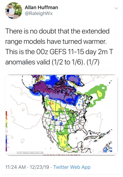
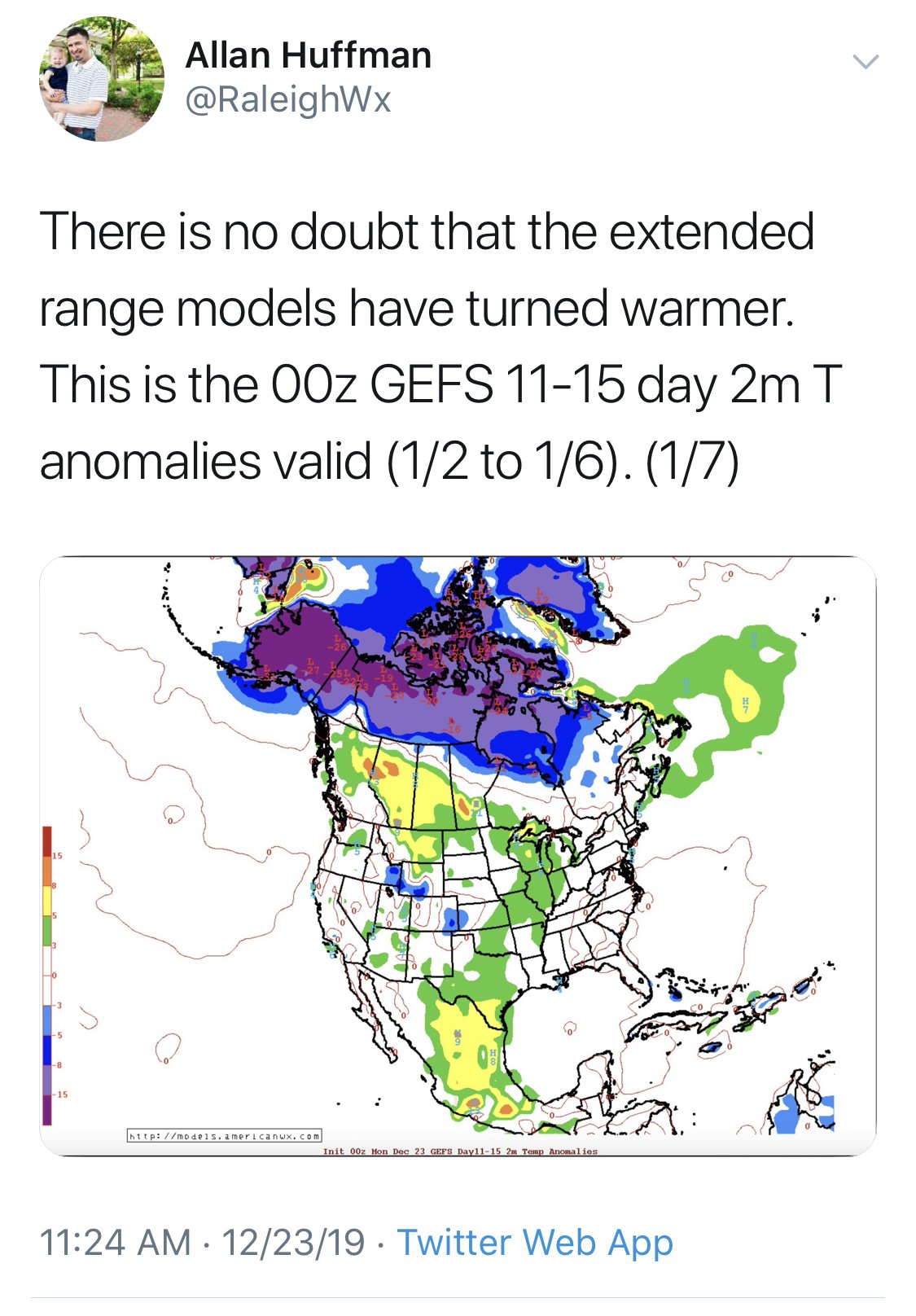
12z GEFS really degraded our snow chances day 10-15. Lost the eastern Canada ridging idea. It’s building a better Atlantic pattern way out at day 16 but it pushed the process back 5 days, back to fantasy range again. Perhaps it’s the right idea but was rushing it but until I see the eps move that way I am skeptical. EPS has been crushing the GEFS lately.
We went through this last year. And every year for a decade it seems. Any kind of favorable Atlantic during winter is always 15 days away and never verifies. A -NAO in winter is a pipe dream anymore. Luckily you guys live up north where you'll still get some snow eventually. I may get blanked for the first time in history and not even be able to muster a flake with my already pathetic 4.7 inch normal.
-
1
-
-
38 minutes ago, mackerel_sky said:
Who will be right? TV Mets or Mid Atlantic weenies?? Hmmmmm....
Some of the more knowledgeable weenies up there are on the edge of the cliff! I've already jumped! You should join me.
-
3
-
-
5 minutes ago, cbmclean said:
Summary of MA thread feeling for today:
Apocalyptically bad pattern incoming. Not only is it horrible, it is the kind of pattern which tends to get dug in for months at a time. Strong Objective-based evidence for fearing for all of January.
See sanitarium post. I'm done. It's over.
-
Head on over to the Mid Atlantic forum and read that PSU guys research. He states what I've seen coming for 2 weeks now. When the Pacific pattern goes this bad as it is now it never recovers. In all his analogs it never recovered. Some winters were better than others because the Atlantic saved them. Don't fall for the false -NAO on the GFS. No Atlantic is saving us this year. This winter is a dud. I can realistically say that even though its only December. We're getting blanked!
It's crazy for the mid Atlantic to give up because they have March. Screw March snows down here. They're rare regardless of what Panovich says. They make up a high percentage of snowfall because they can be heavy when they occur. They don't occur that often outside the mountains. This ain't 1960 anymore.
-
1
-
1
-
-
When there hasn't been a post in almost 2 days in the main thread going into peak climo you know it's bad. Winter 19-20 will go down as one to forget.
-
2
-
1
-
-
1 hour ago, BooneWX said:
For the love of god please tell me the cycle ends at some point.
It will in March.
-
1
-
1
-
-
32 minutes ago, Southern Track said:
Remember last winter when all those late model runs showed the western ridge with the Greenland block that never verified.
Don't worry. That horrific look will verify with flying colors though.
-
1
-
-
21 minutes ago, SnowNiner said:
Agreed. The western trough sets up and never lets go. December is toast for the SE if the ensembles consensus is right; lights out till January. That's kinda every year so...no big whoop. I'm just hoping we kick it east by new year.
Every. Single. Year. Question is how much of Jan goes down the shitter? That's the peak climo month.
-
1
-
1
-
-
11 minutes ago, IWC said:
Bring on the snow for Christmas!!!
Where are you spending Christmas then? Sure ain't the SE.
-
1
-
1
-
1
-
Mid to Long Term Discussion 2020
in Southeastern States
Posted
Better enjoy it now! You won't get any come June!