

Hotair
-
Posts
432 -
Joined
-
Last visited
Content Type
Profiles
Blogs
Forums
American Weather
Media Demo
Store
Gallery
Posts posted by Hotair
-
-
Port Charlotte 120 MPH
-
 1
1
-
-
A watched ERC never completes.
-
 1
1
-
-
We have two recon planes investigating Ian at this moment. We should know more soon about the state of intensification and eyewall structure.
-
12 minutes ago, Ed, snow and hurricane fan said:
I think it is phosphate fertilizer production. Just reading about concentrations of radon producing trace amounts of radium in the waste. Radiation gets the publicity, but the heavy metals, if I had to guess, would be a bigger danger to wildlife. Construction gypsum is apparently lower in the radium. Or they couldn't use it in construction. The only thing I know about gypsum, really, is its desiccated cousin anhydrite is found in outcrops on the Colorado River in Bastrop. The other Colorado River.
It is tied to fertilizer production. Stuff is a nightmare to clean up. We had an accidental release of some of the water into the bay and it resulted in massive red tide. These companies come and mine and promise they will clean it up after. Except one by one they simply declare bankruptcy of the LLC they create and move on to the next project under a new one leaving the state holding the bag (except the state is fully in cohoots with these companies).
-
1
-
-
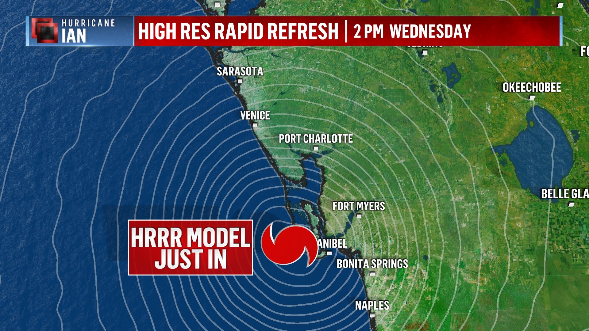
This model is calling for Sanibel landfall
Our short-range high-resolution weather models are now close enough to landfall for a forecast. This is the High Resolution Rapid Refresh model. Comes out every hour. This run brings #Ian to Sanibel 2 pm
-
1
-
 10
10
-
-
2 minutes ago, Floydbuster said:

The 1919 Hurricane is counted as a 927 mb - 150 mph U.S. Landfall in the Dry Tortugas, so I do believe a landfall would count despite the lack of habitation.
If it does make a DT landfall I can see it being a heck of a game show question 20 years from now. Q - “Major Hurricane Ian which caused Billions in damage first made landfall in this part of the United States “ A - What is Dry Tortuga ?
-
4
-
2
-
-
2 minutes ago, HIPPYVALLEY said:
Inland hydro issues will become a big story me thinks. Especially if Ian pulls off some of the higher end model projections.
There is a significant risk that the gypsum mining wastewater storage facilities could be compromised. If so it will be a total clusterf#$k environmental disaster
-
The ENTIRE island of Cuba is without electricity tonight.
-
1
-
-
photos of planes overturned due to tornado in Hollywood airport.
https://twitter.com/TotalTrafficMIA/status/1574925334008696832?s=20&t=CTw6BLbZb1P4yRD_vABVlA
-
1
-
 1
1
-
-
31 minutes ago, StantonParkHoya said:
I would bet that’s a normalish number on a regular day out of a 13M home pop
The outages are primarily in the keys right now
-
31 minutes ago, Maestrobjwa said:
Pardon my ignorance, but what is that for? Unclean water contamination from storm surge, or?
I’m not an expert but my son (electrician) says they likely are taking the pumps offline to prevent damage from expected electrical line surges/brown outs. He has seen some communities do that when the possibility of damage is high and replacing the pump motors is difficult due to lack of spares etc. take this with grain of salt. It is a major inconvenience to lose water this early into a storm
-
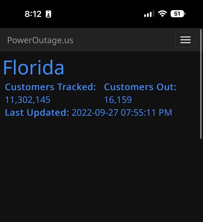
Already 16,000 customers in Florida without power and storm is still well offshore.
-
-
Started tracking more easterly but is this consistent with the models that ended recently?
-
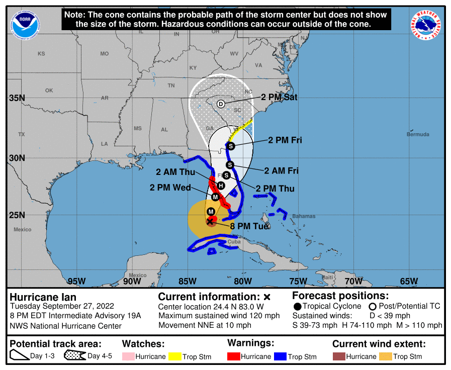
000
WTNT34 KNHC 272352
TCPAT4

BULLETIN
Hurricane Ian Intermediate Advisory Number 19A
NWS National Hurricane Center Miami FL       AL092022
800 PM EDT Tue Sep 27 2022

...LIFE-THREATENING STORM SURGE, CATASTROPHIC WINDS AND FLOODING
EXPECTED IN THE FLORIDA PENINSULA...


SUMMARY OF 800 PM EDT...0000 UTC...INFORMATION
----------------------------------------------
LOCATION...24.4N 83.0W
ABOUT 180 MI...290 KM SSW OF PUNTA GORDA FLORIDA
ABOUT 20 MI...35 KM SSW OF THE DRY TORTUGAS
MAXIMUM SUSTAINED WINDS...120 MPH...195 KM/H
PRESENT MOVEMENT...NNE OR 15 DEGREES AT 10 MPH...17 KM/H
MINIMUM CENTRAL PRESSURE...947 MB...27.96 INCHES


WATCHES AND WARNINGS
--------------------
CHANGES WITH THIS ADVISORY:

None.

SUMMARY OF WATCHES AND WARNINGS IN EFFECT:

A Hurricane Warning is in effect for...
* Chokoloskee to Anclote River, including Tampa Bay
* Dry Tortugas

A Storm Surge Warning is in effect for...
* Suwannee River southward to Flamingo
* Tampa Bay
* Dry Tortugas
* Flagler/Volusia Line to the mouth of the St. Mary's River
* St. Johns River

A Tropical Storm Warning is in effect for...
* Cuban provinces of La Habana, Mayabeque, and Matanzas
* Suwannee River to the Anclote River
* All of the Florida Keys
* Flamingo to Altamaha Sound
* Flamingo to Chokoloskee
* Lake Okeechobee
* Florida Bay
* Bimini and Grand Bahama Islands

A Storm Surge Watch is in effect for...
* Florida Keys from the Card Sound Bridge westward to Key West
* Florida Bay
* Mouth of St. Mary's River to South Santee River

A Tropical Storm Watch is in effect for...
* North of Altamaha Sound to South Santee River

A Storm Surge Warning means there is a danger of life-threatening
inundation, from rising water moving inland from the coastline, in
the indicated locations. For a depiction of areas at risk, please
see the National Weather Service Storm Surge Watch/Warning Graphic,
available at hurricanes.gov.  This is a life-threatening situation.
Persons located within these areas should take all necessary actions
to protect life and property from rising water and the potential for
other dangerous conditions.  Promptly follow evacuation and other
instructions from local officials.

A Hurricane Warning means that hurricane conditions are expected
somewhere within the warning area.  Preparations to protect life and
property should be rushed to completion.

A Tropical Storm Warning means that tropical storm conditions are
expected somewhere within the warning area.

A Storm Surge Watch means there is a possibility of life-
threatening inundation, from rising water moving inland from the
coastline, in the indicated locations during the next 48 hours.

A Tropical Storm Watch means that tropical storm conditions are
possible within the watch area.

For storm information specific to your area, please monitor
products issued by your national meteorological service.


DISCUSSION AND OUTLOOK
----------------------
At 800 PM EDT (0000 UTC), the center of Hurricane Ian was located
near latitude 24.4 North, longitude 83.0 West.  Ian is moving toward
the north-northeast near 10 mph (17 km/h).  This general motion
with a reduction in forward speed is forecast tonight and Wednesday.
On the forecast track, the center of Ian is expected to pass west
of the Florida Keys later tonight, and approach the west coast of
Florida within the hurricane warning area on Wednesday and Wednesday
night.

Maximum sustained winds are near 120 mph (195 km/h) with higher
gusts.  Ian is a category 3 hurricane on the Saffir-Simpson
Hurricane Wind Scale.  Strengthening is expected tonight through
Wednesday.  Ian is forecast to approach the west coast of Florida as
an extremely dangerous major hurricane.

Hurricane-force winds extend outward up to 40 miles (65 km) from
the center and tropical-storm-force winds extend outward up to 140
miles (220 km). Sustained tropical-storm-force winds have been
reported at the Key West International Airport and the Key West
Naval Air Station during the last hour. A National Data Buoy
Center Site near Sombrero Key recently reported a sustained wind of
43 mph (69 km/h). The Florida Keys Marathon International Airport
just reported a wind gust to 52 mph (84 km/h).

The minimum central pressure estimated from NOAA Hurricane Hunter
aircraft observations is 947 mb (27.96 inches).


HAZARDS AFFECTING LAND
----------------------
Key messages for Ian can be found in the Tropical Cyclone Discussion
under AWIPS header MIATCDAT4 and WMO header WTNT44 KNHC and on the
web at hurricanes.gov/text/MIATCDAT4.shtml.

STORM SURGE:  The combination of storm surge and the tide will cause
normally dry areas near the coast to be flooded by rising waters
moving inland from the shoreline.  The water could reach the
following heights above ground somewhere in the indicated areas if
the peak surge occurs at the time of high tide...

* Middle of Longboat Key to Bonita Beach, including Charlotte
Harbor...8-12 ft
* Bonita Beach to Chokoloskee...6-9 ft
* Anclote River to Middle of Longboat Key, including Tampa
Bay...4-6 ft
* Suwannee River to Anclote River...3-5 ft
* Mouth of the St. Mary's River to Altamaha Sound...4-6 ft
* Chokoloskee to East Cape Sable...4-6 ft
* Dry Tortugas...3-5 ft
* Flagler/Volusia County Line to Mouth of the St. Mary's River,
including St. Johns River...3-5 ft
* Altamaha Sound to Savannah River...3-5 ft
* St. Johns River south of Julington...2-4 ft
* Savannah River to South Santee River...2-4 ft
* East Cape Sable to Card Sound Bridge...2-4 ft
* Florida Keys...2-4 ft
* Patrick Air Force Base to Flagler/Volusia County Line...1-3 ft
* Indian Pass to Suwanee River...1-3 ft

The deepest water will occur along the immediate coast near and to
the right of the center, where the surge will be accompanied by
large waves.  Surge-related flooding depends on the relative timing
of the surge and the tidal cycle, and can vary greatly over short
distances.  For information specific to your area, please see
products issued by your local National Weather Service forecast
office.

WIND:  Hurricane conditions are expected along the west coast of
Florida within the Hurricane Warning area on Wednesday morning, with
tropical storm conditions possibly beginning tonight.

Tropical storm conditions are occurring in the warning area in the
Florida Keys, and will continue overnight.  Tropical storm
conditions are expected in the warning area on the east coast of
Florida beginning early Wednesday, and should spread up to Georgia
and South Carolina on Thursday.  Tropical storm conditions are
expected within the warning area in Cuba for the next few hours.

RAINFALL: Ian is expected to produce the following rainfall through
Thursday night:

* Western Cuba: 6 to 12 inches, with isolated totals up to 16
inches. These rains may produce flash flooding and mudslides in
areas of higher terrain over western Cuba.
* Florida Keys and South Florida: 6 to 8 inches, with isolated
totals up to 12 inches.
* Central and Northeast Florida: 12 to 18 inches, with isolated
totals up to 24 inches.
* Eastern Georgia and coastal South Carolina: 4 to 8 inches, with
isolated totals up to 12 inches.

Widespread catastrophic flash, urban, and river flooding is expected
across central and west Florida beginning midweek.  Widespread
considerable flash, urban, and river flooding is expected across
northern Florida, southeastern Georgia, and coastal South Carolina
from the end of the week through the weekend.  Limited river
flooding is expected over portions of the southeastern United
States into the Mid-Atlantic mid-to-late week.

TORNADOES: Tornadoes are possible through Wednesday across central
and south Florida.

SURF:  Swells generated by Ian are affecting the western Caribbean
and the Florida Keys, and will spread northward throughout the
eastern Gulf of Mexico tonight and Wednesday.  These swells are
likely to cause life-threatening surf and rip current conditions.
Please consult products from your local weather office.


NEXT ADVISORY
-------------
Next complete advisory at 1100 PM EDT.

$$
Forecaster Pasch/D. Zelinsky/Bucci
-
Water is being turned off in Sarasota.
-
Recon at 946 mb. Are we sure the ERC os still underway? Lol. Ian is not relaxing whatsoever.
-
1
-
-
Lots of tornadic action from the outer bands crossing into South Florida. I don’t recall hearing of this high level of tornado activity either when Ian approached Caymans or Cuba. Does anyone know what seems to be more favorable in S FL that gives rise to tornado genesis?
-
3
-
1
-
-
000
WTNT64 KNHC 272256
TCUAT4

Hurricane Ian Tropical Cyclone Update
NWS National Hurricane Center Miami FL       AL092022
700 PM EDT Tue Sep 27 2022

...7 PM EDT HURRICANE IAN POSITION UPDATE...
...LIFE-THREATENING STORM SURGE, CATASTROPHIC WINDS AND FLOODING
EXPECTED WITH IAN IN THE FLORIDA PENINSULA...

The estimated minimum central pressure based on recent observations
from a NOAA Hurricane Hunter Aircraft is 947 mb (27.96 inches).

During the last hour, the Key West International Airport reported a
sustained wind of 48 mph (77 km/h) with a gust to 71 mph (114
km/h).

SUMMARY OF 700 PM EDT...2300 UTC...INFORMATION
----------------------------------------------
LOCATION...24.3N 83.1W
ABOUT 200 MI...320 KM SSW OF PUNTA GORDA FLORIDA
ABOUT 30 MI...50 KM SSW OF THE DRY TORTUGAS
MAXIMUM SUSTAINED WINDS...120 MPH...195 KM/H
PRESENT MOVEMENT...N OR 10 DEGREES AT 10 MPH...17 KM/H
MINIMUM CENTRAL PRESSURE...947 MB...27.96 INCHES

$$
Forecaster Bucci/D. Zelinsky
-
704
WTNT64 KNHC 272157
TCUAT4

Hurricane Ian Tropical Cyclone Update
NWS National Hurricane Center Miami FL       AL092022
600 PM EDT Tue Sep 27 2022

...6 PM EDT HURRICANE IAN POSITION UPDATE...
...LIFE-THREATENING STORM SURGE, CATASTROPHIC WINDS AND FLOODING
EXPECTED WITH IAN IN THE FLORIDA PENINSULA...

The Key West International Airport recently reported a sustained
wind of 41 mph (66 km/h) with a gust to 60 mph (96 km/h).  A
WeatherFlow station at the Key West Coast Guard recently reported a
wind gust to 54 mph (87 km/h).

SUMMARY OF 600 PM EDT...2200 UTC...INFORMATION
----------------------------------------------
LOCATION...24.1N 83.1W
ABOUT 210 MI...340 KM SSW OF PUNTA GORDA FLORIDA
ABOUT 45 MI...70 KM SSW OF THE DRY TORTUGAS
MAXIMUM SUSTAINED WINDS...120 MPH...195 KM/H
PRESENT MOVEMENT...N OR 10 DEGREES AT 10 MPH...17 KM/H
MINIMUM CENTRAL PRESSURE...952 MB...28.12 INCHES

$$
Forecaster Bucci/D. Zelinsky
-
Here’s something new to consider
The 18z NAM was very intriguing. Shows Ian coming off of Florida at 993 mb and deepening to 971 mb before making another landfall in SC. The same thing shearing it may provide a pattern for re-intensification, and there is enough warmth in the Gulf Stream. Something to watch.-
2
-
-
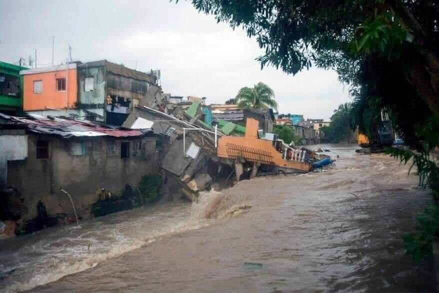
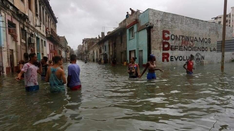
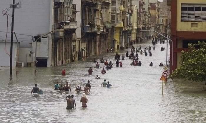
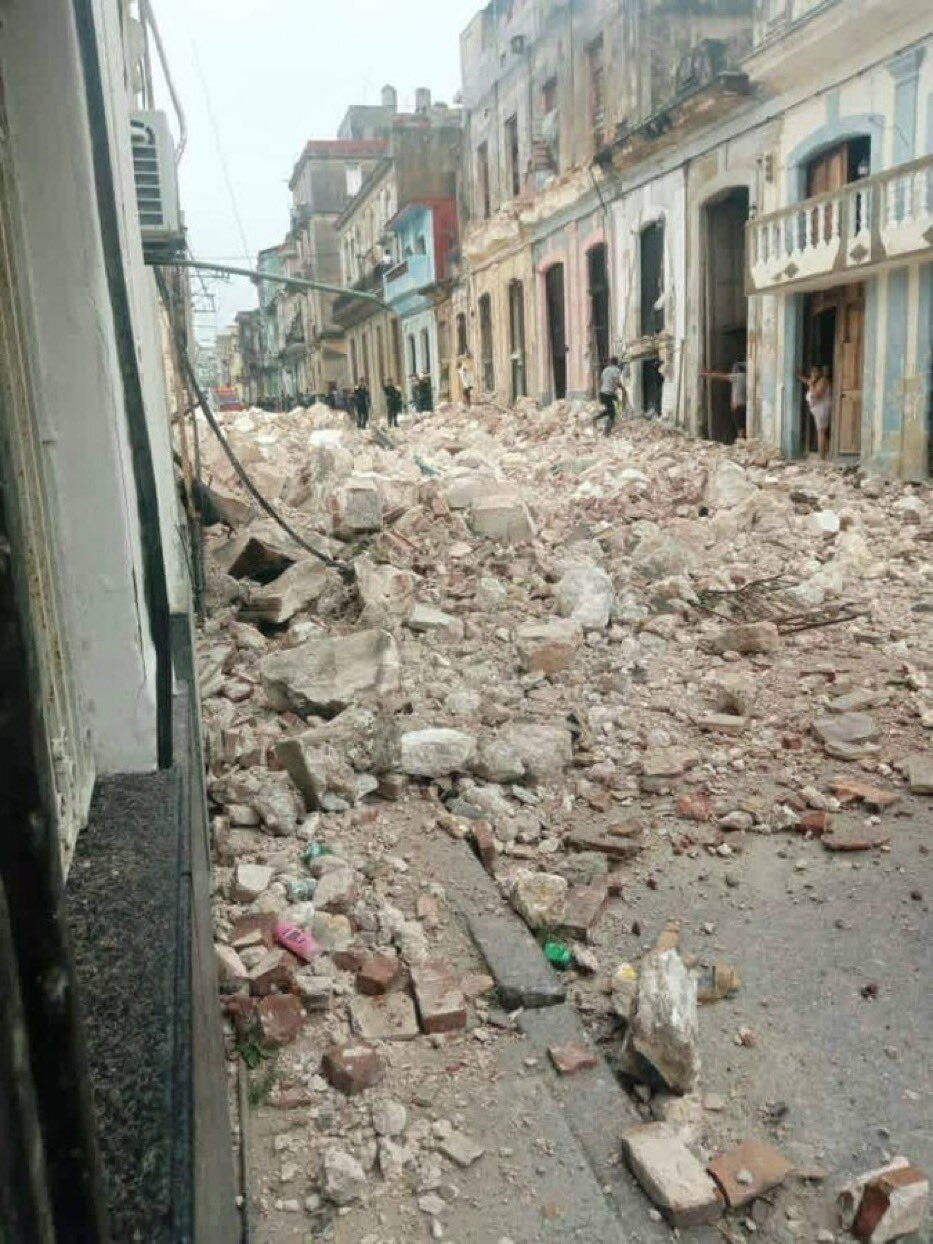
Pics coming out of Cuba tell quite the story for Ian
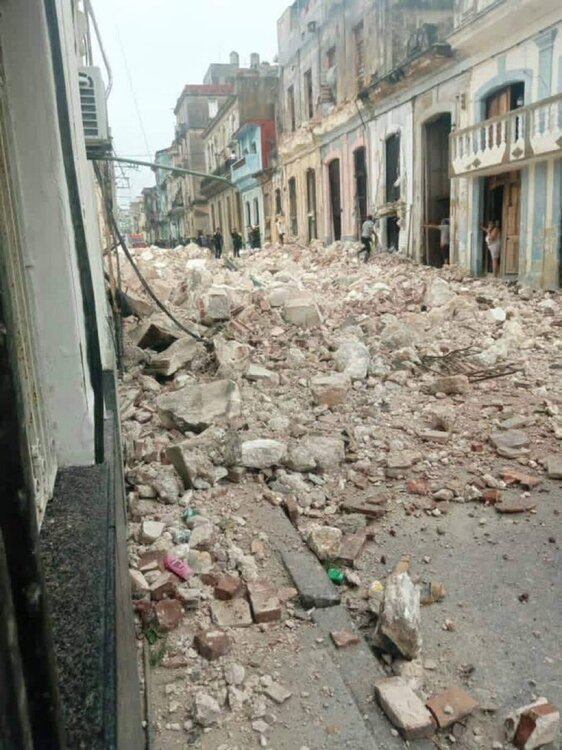
-
2
-
-
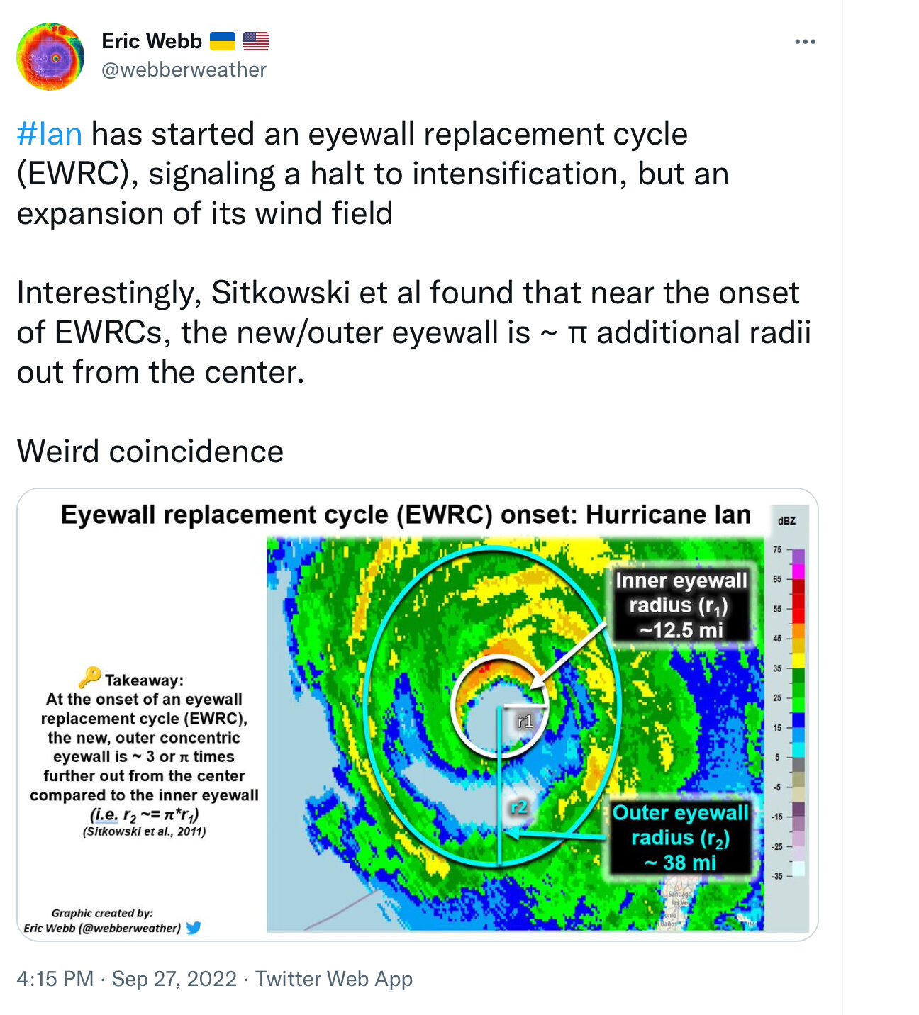
Ian in process of expanding its eyewall windfield by ~3x

-
 1
1
-
-
4:00 PM public advisory update

451
WTNT64 KNHC 271958
TCUAT4

Hurricane Ian Tropical Cyclone Update
NWS National Hurricane Center Miami FL       AL092022
400 PM EDT Tue Sep 27 2022

...4 PM EDT HURRICANE IAN POSITION UPDATE...

In the past hour, the Cuba Institute of Meteorology located in
Havana reported a sustained wind of 56 mph (90 km/h) with a gust to
87 mph (140 km/h).

SUMMARY OF 400 PM EDT...2000 UTC...INFORMATION
----------------------------------------------
LOCATION...23.8N 83.2W
ABOUT 250 MI...400 KM S OF SARASOTA FLORIDA
ABOUT 65 MI...105 KM SSW OF THE DRY TORTUGAS
MAXIMUM SUSTAINED WINDS...120 MPH...195 KM/H
PRESENT MOVEMENT...N OR 10 DEGREES AT 10 MPH...17 KM/H
MINIMUM CENTRAL PRESSURE...952 MB...28.11 INCHES

$$
Forecaster Papin


Hurricane Ian
in Tropical Headquarters
Posted
Isaiah_Wx CODE RED
@IsaiahHartzell2
RECON has support for a 140 kt storm, 160 MPH, Cat. 5. The next plane is going in for another pass