

Hotair
-
Posts
540 -
Joined
-
Last visited
Content Type
Profiles
Blogs
Forums
American Weather
Media Demo
Store
Gallery
Posts posted by Hotair
-
-
For us here in the TB area the only positive aspect to this storm presently is how small it is. Much smaller than Helene was. Therefore, the major wind impacts are likely to be felt over a much narrower swath of real estate. Any minor wobble to the South of the Metro area could spare this highly populated region from catastrophic winds and surge. It’s the stubborn models that for now curve it northward that worry me most.
-
1 minute ago, DDweatherman said:
Yep, I saw this today. Where are you in this? South Tampa near Davis? TI, Madeira and SPB, Ana Maria, etc. are even worse.
South Tampa. Also friends in St Pete Beach across from the Tradewinds Same thing hundreds of streets with houses that have puked their guts unto the driveway. Raining hard now
-
 1
1
-
-
We are not ready for any level of storm in Tampa Bay
-
 1
1
-
8
-
 1
1
-
-
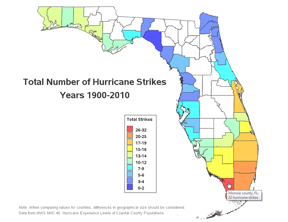
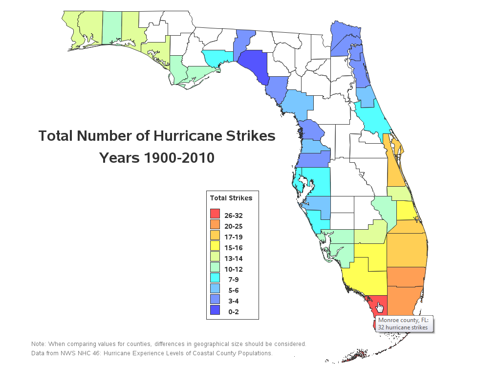
110 years of hurricane data reflects just how fortunate the West Coast has been in the last century.
-
2
-
-
4 minutes ago, USCG RS said:
This looks to be a potentially large storm again. Furthermore, those just hit need to closely monitor this, if possible.
And those just hit need to meticulously document with photos and videos the current state of their homes and roofs A wind event will likely be fought tooth and nail by the insurance companies who will argue for prior storm surge flood damage.
-
3
-
1
-
-
6 minutes ago, dan11295 said:
Good chance that's just the HWRF with its occasional run that really overdoes the intensity. Obviously anyone on the west coast of Florida should be preparing for a major hurricane.
That’s the thing. Few people I see are dealing with this yet. Plus the city has no real plans to deal with the garbage that is being generated by the flooded homeowners who are stacking their wet junk outside their driveways. I am terrified.
-
1
-
2
-
-
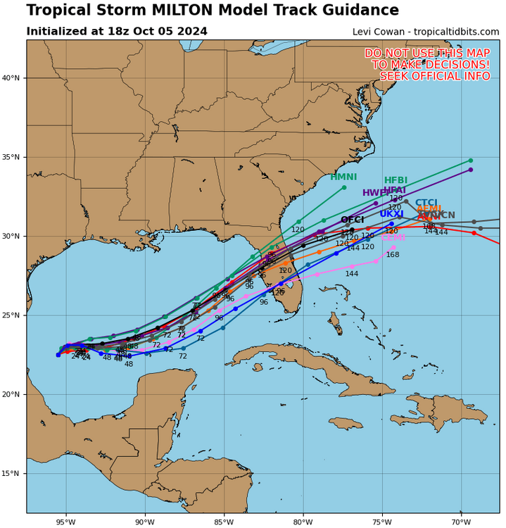
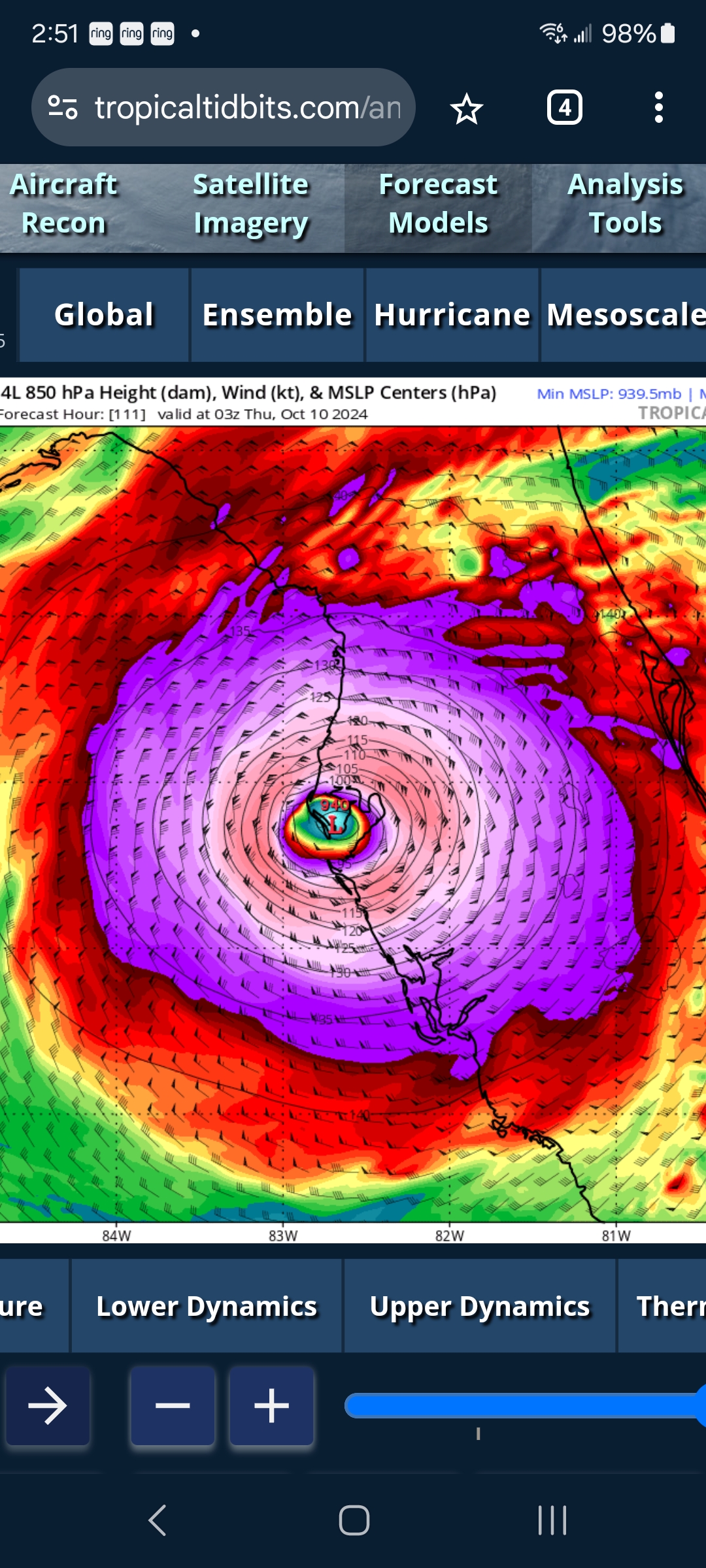
One of the key points made by NHC in this latest advisory is as follows
“the average NHC 4-day track error is about 150
miles”
hopefully (for TB’s sake) NHC’s track error on this one is an outlier.
-
6 minutes ago, WxSynopsisDavid said:
Track scenarios are split: north of Tampa Bay or right over Ft. Myers. Both tracks would be devastating with catastrophic storm surge.
Saving grace would be an eyewall replacement cycle but in actual reality that wouldn’t help much.
Environment supports Milton landfalling at peak intensity. To complicate matters, the critical angle of approach to compound the storm surge threat.
Split but the vast majority of tracks favor the devastation of TB at the moment. The tight bundling leaves relatively little room for track error
-
1
-
-
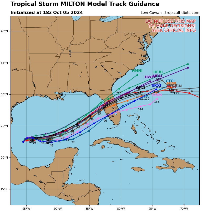
10 minutes ago, cptcatz said:
Is this the most frightening model image seen in a long time?

Given it affects the largest population center in Western Florida, it most certainly is.
-
1
-
-
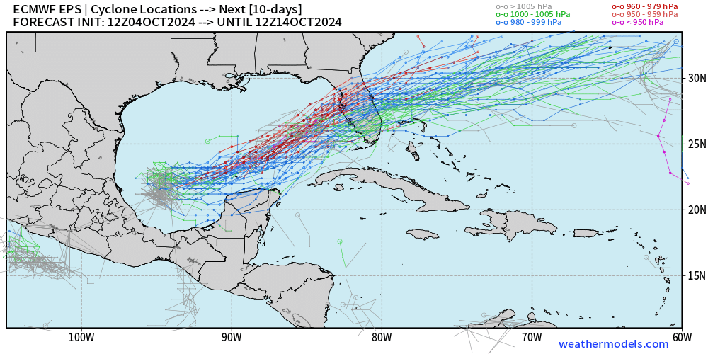
2 minutes ago, IUsedToHateCold said:
Any possibility this thing goes south of where the models have it now? Ideally, south of Florida altogether?
Model agreement seems to be converging We could hope for some dry air front or some other system to disrupt Milton somewhat but each hour makes a miss less likely. I believe mets will tell you yes there is always a possibility with nearly 3 days out
-
1
-
-
I don’t think many people from outside the area here fully appreciate the situation we find ourselves in here around the shore areas of Tampa Bay
there’s literally piles ten feet high of debris , discarded furniture, appliances and miscellaneous crap up and down the coast for miles and miles. I doubt much of it will be picked up by the time the rains hit. Any surge or even just heavy rains in this area will push that stuff into houses and cars and create tremendous hazards for anyone caught in the flood path.
if we get cane strength winds ahead of the flooding then all those items will also go flying. I mean you couldn’t script a more damaging scenario if you tried.
i also failed to mention how all that crap by the side of the roads will certainly clog up our storm drains in short order. A mild surge can then turn into a major flood even in areas that don’t normally flood.
-
1
-
 1
1
-
4
-
-
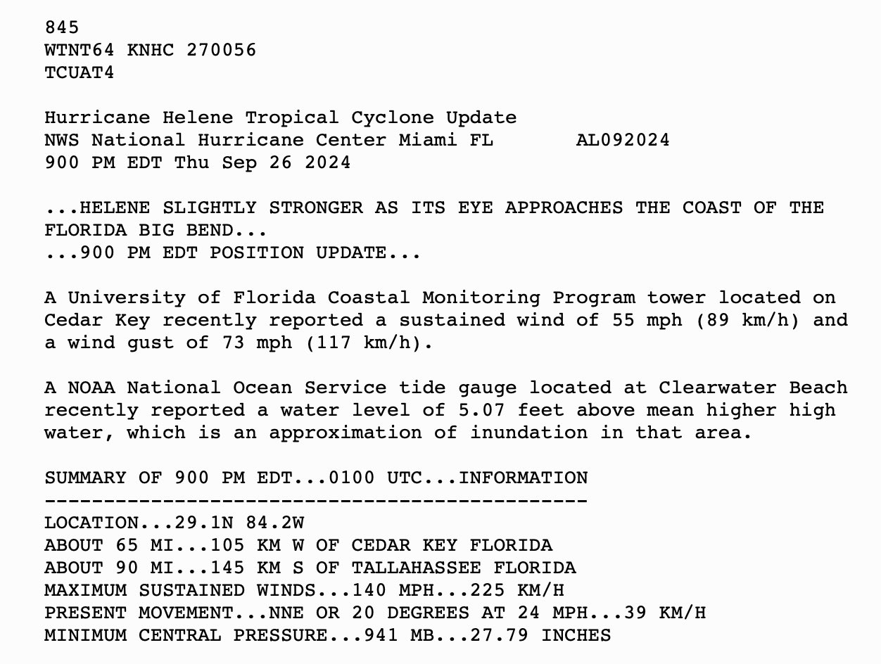
14 minutes ago, George BM said:
The NHC forecast is fairly bullish with an intensity of 95kts for the 72 and 96 hour points.
Ugghhh. There is no scenario evolving where the Tampa Bay Area is not at risk of major flooding yet again. We have debris from Helene piled up for miles along the roads some reaching ten feet high. Flood waters will just carry that stuff and smash it everywhere.
-
4
-
2
-
-
When we talk about a weak system moving into TB, are we talking weak as in weaker than what TB experienced with Helene as she stayed 150 miles offshore? I’m gonna guess not.
the area still has lots of debris sitting in the open from the prior storm. Saturated ground, and compromised structures. Any system moving water into the bay will be a major one-two punch for many here.
-
51 minutes ago, andyhb said:
Big signal from the 12z EPS members...
Nightmare scenario for Tampa Bay. Imagine navigating the insurance complexities of back to back flooding events combined perhaps with wind damage this time around? I know someone who wrongfully skipped on flood insurance because of his elevation on the map (zone C) only to see nearly 6 inches of water yesterday in his home because the storm drains were at capacity and the retention pond behind his house kept filling up
-
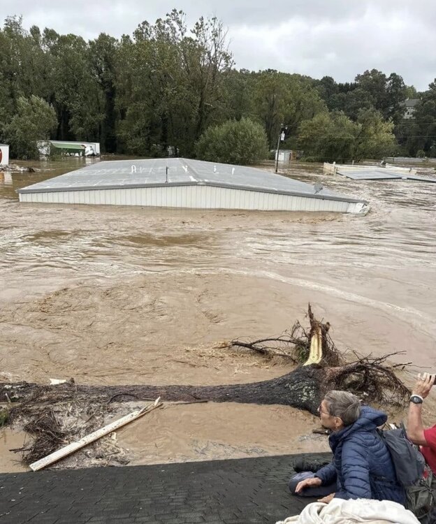
Last image of a wife and husband in Asheville, NC sheltering from the flood on a roof. The roof would soon collapse, causing them and their 6 year old grandchild to drown.Their daughter and mother of the child took the photograph. When the roof collapsed, she got wedged between debris and was able to be rescued an hour later.
-
1
-
2
-
-
Interesting fact about Asheville NC. Asheville is over 2,000 feet above sea level, and ~300 miles away from the nearest coastline. A reminder that storm flooding can be a huge problem for many areas of the country, not just coastline communities.
-
3
-
3
-
-
5 hours ago, MANDA said:
At least it had the courtesy of clearing itself off the road after.
-
First fatality due to Helene being reported. Sign falls onto Car

-
4
-
-
-
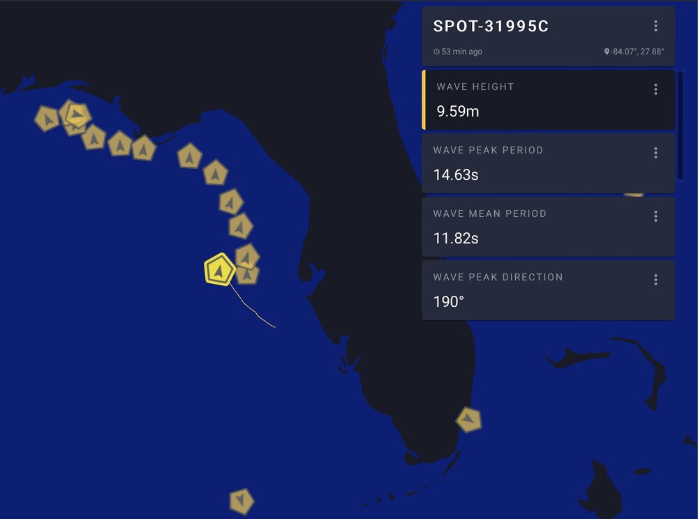
17 minutes ago, wthrmn654 said:
31? Which buoy is that by chance the one that's less then 31 miles away is showing 20 feet now
I thought it was 42036 but that one is coming up now. I haven’t been able to cross reference the image.
-
Buoy off Florida recording 31 foot waves near Helene
-
2
-
-
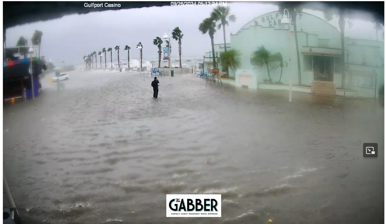
2 minutes ago, Prospero said:
Low tide was over about a half hour ago and we have along ways to go to high tide after midnight. Already the water level is rising. Here in Gulfport we are used to seeing downtown flooded, but tonight could be the first time it will be too deep for people to wade in and around. It could be over everybody's heads in a few hours.
I notice the cameras are slow to load and that is because so many people are watching them. But after a moment or so you can see a live stream:
https://thegabber.com/gulfport-casino-web-cam/
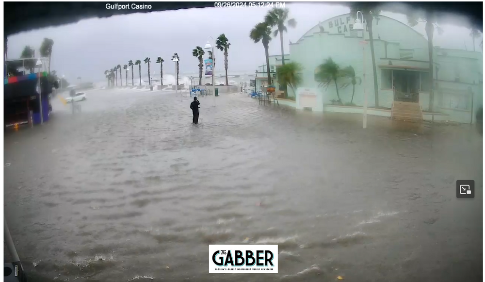
People leaving their cars to get bathed in salt water don’t seem so bright.
-
2
-
 2
2
-
1
-
-
A Newly Released Image of Planet Earth Taken 30 Minutes Ago By the GOES-East Satellite. Helene can be seen

-
1
-
2
-
-
Howard Frankland bridge has been shut down connecting Tampa to Clearwater


Major Hurricane Milton
in Tropical Headquarters
Posted
This was absolutely necessary. A shame it didn’t get started yesterday.