StormChazer
-
Posts
1,231 -
Joined
-
Last visited
Content Type
Profiles
Blogs
Forums
American Weather
Media Demo
Store
Gallery
Everything posted by StormChazer
-

MO/KS/AR/OK 2020-2021 "Winter" Discussion
StormChazer replied to JoMo's topic in Central/Western States
Looks fairly similar to last night's run, SW MO and central OK doesn't get as much, but NW AR gets a little more(goes from about 6 to almost 8). Tulsa down 1.5 inches. Interestingly, the Euro isn't sniffing out the heavy band that sets up tonight, like the short range models are, so that will make a difference if it happens. -
MO/KS/AR/OK 2020-2021 "Winter" Discussion
StormChazer replied to JoMo's topic in Central/Western States
TSA. Our attention then focuses on the winter storm which is expected to impact parts of eastern Oklahoma after midnight tonight. The latest hi-res guidance has shown a consistent signal for a heavy but narrow frontogenetical band to set up somewhere over central and eastern Oklahoma ahead of the main wave of snow. This potential band will need to be watched for a quick 2 to 4 inches if not more before sunrise. As a result, locations within this band will see conditions deteriorate rapidly. The exact location of this band is still in question and the details of the winter storm overall will be ironed out in the afternoon forecast package. -
MO/KS/AR/OK 2020-2021 "Winter" Discussion
StormChazer replied to JoMo's topic in Central/Western States
Norman has some text to go with it. Basically talking about that first band we are seeing on models and how it’ll provide some noticeable added inches before the “main event”,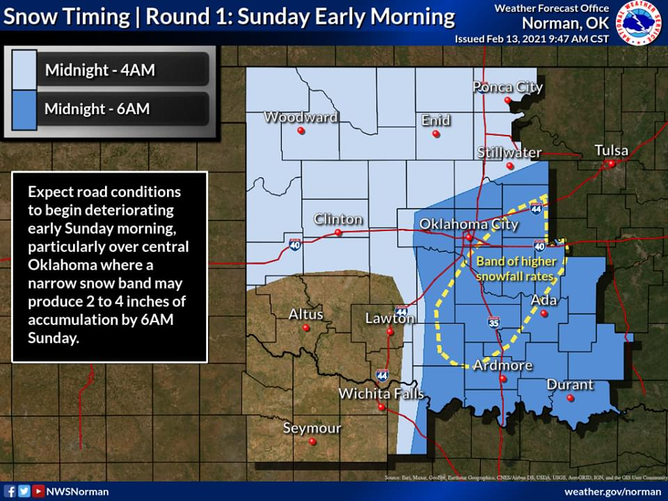
-
MO/KS/AR/OK 2020-2021 "Winter" Discussion
StormChazer replied to JoMo's topic in Central/Western States
Yeah that 2nd Storm goes nuts. Idk that we would use kuchera values for the 2nd storm....might be more like 15:1?
-
MO/KS/AR/OK 2020-2021 "Winter" Discussion
StormChazer replied to JoMo's topic in Central/Western States
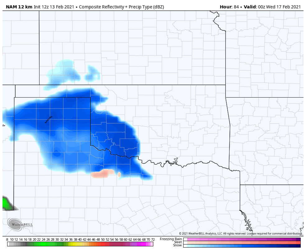
Hour 84 of NAM FWIW.
-
MO/KS/AR/OK 2020-2021 "Winter" Discussion
StormChazer replied to JoMo's topic in Central/Western States
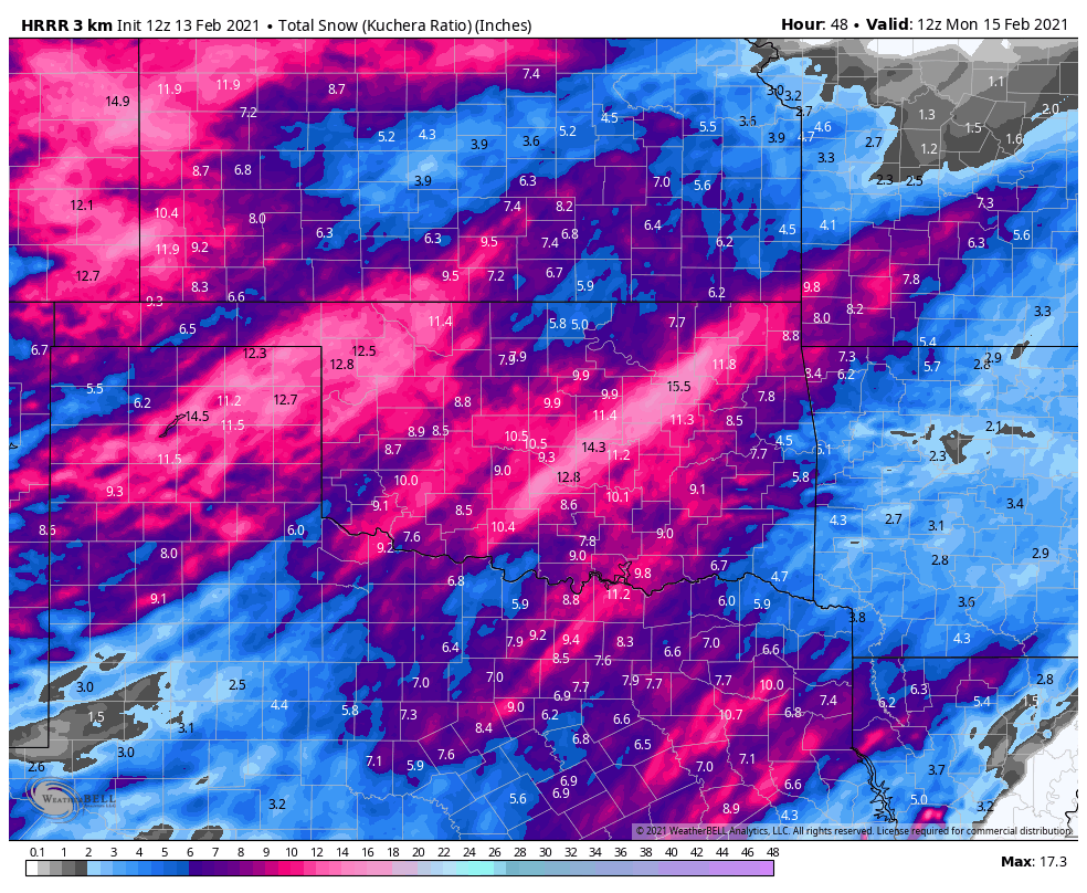
Loving this new trend on the short term models. It would appear our snow in Tulsa is highly dependent on that initial band coming though.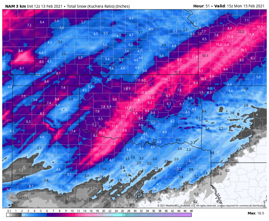
-
MO/KS/AR/OK 2020-2021 "Winter" Discussion
StormChazer replied to JoMo's topic in Central/Western States
Yup, lock this in please.
-
MO/KS/AR/OK 2020-2021 "Winter" Discussion
StormChazer replied to JoMo's topic in Central/Western States
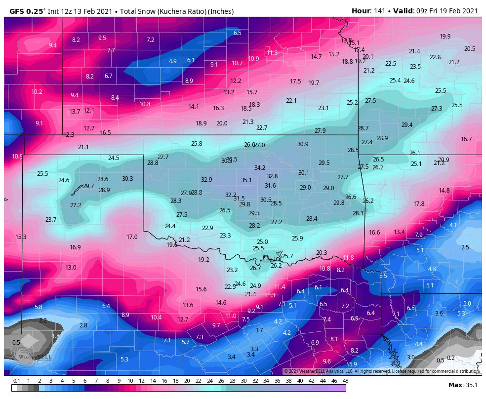
One storm at a time I know. But both the GFS and Canadian have trended towards a much snowier solution for the 2nd storm. Not much changes overnight on the models. -
MO/KS/AR/OK 2020-2021 "Winter" Discussion
StormChazer replied to JoMo's topic in Central/Western States
Euro still lookin good in my neck of the woods. -
MO/KS/AR/OK 2020-2021 "Winter" Discussion
StormChazer replied to JoMo's topic in Central/Western States
You know I will be. -
MO/KS/AR/OK 2020-2021 "Winter" Discussion
StormChazer replied to JoMo's topic in Central/Western States
00Z GFS looks about the same as the 18Z, with the exception of central OK amped up a little more. -
MO/KS/AR/OK 2020-2021 "Winter" Discussion
StormChazer replied to JoMo's topic in Central/Western States
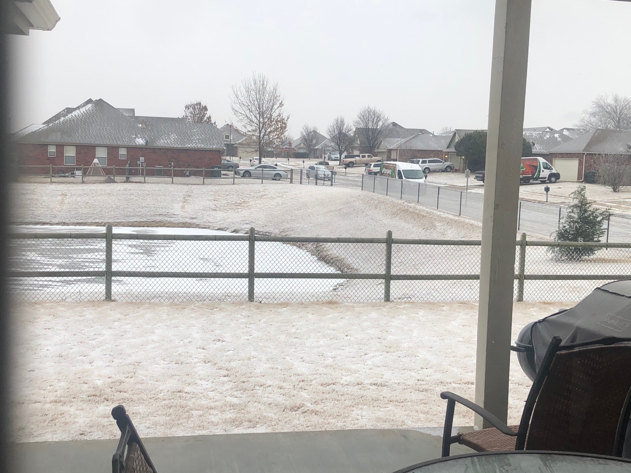
Yup, just went outside for about 10 min. Can see the snow blowing around on the roads and just a pretty, light, snow. -
MO/KS/AR/OK 2020-2021 "Winter" Discussion
StormChazer replied to JoMo's topic in Central/Western States
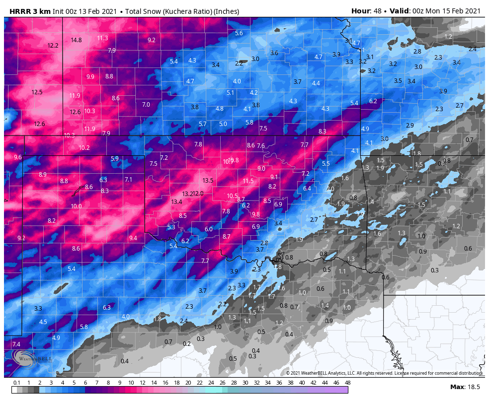
00Z HRRR so far.
-
MO/KS/AR/OK 2020-2021 "Winter" Discussion
StormChazer replied to JoMo's topic in Central/Western States
Correct! TSA had it in a few of their past discussions. lake Oologah NE of town. I live slightly downwind of the lake here in Owasso. I’ll try to attach a pic so you can see the dusting it’s given us.
-
MO/KS/AR/OK 2020-2021 "Winter" Discussion
StormChazer replied to JoMo's topic in Central/Western States
Might I remind many of you that the 12Z Euro was looking pretty nice for alot of us. -
MO/KS/AR/OK 2020-2021 "Winter" Discussion
StormChazer replied to JoMo's topic in Central/Western States
From TSA in their disco. Since impacts will probably hold off until after 12Z Sunday, northwest Arkansas will remain in a watch. While the exact details will continue to change with new data, overall the message remains the same. This system will be a big deal, and will likely cause significant travel impacts. -
MO/KS/AR/OK 2020-2021 "Winter" Discussion
StormChazer replied to JoMo's topic in Central/Western States
TSA is in the process of updating their map so the numbers aren't going to add up just yet. -
MO/KS/AR/OK 2020-2021 "Winter" Discussion
StormChazer replied to JoMo's topic in Central/Western States
If this heavy band really lays down this much prior to the main storm that would be crazy. -
MO/KS/AR/OK 2020-2021 "Winter" Discussion
StormChazer replied to JoMo's topic in Central/Western States
-
MO/KS/AR/OK 2020-2021 "Winter" Discussion
StormChazer replied to JoMo's topic in Central/Western States
Pretty neat snippet from TSA on the lake effect snowband from Oologah. 40:1 SNOW RATIO from this band. I wonder if this is it's own beast, or if this means there is a 40:1 potential for the system in 2 days. Surely not I would think...because that would be outrageous. Can anyone with more knowledge on this educate me? "The other concern in the short term continues to be lake effect snow streaming off of Lake Oologah. The latest radar imagery continues to show a relatively impressive and narrow band of snow streaming off of Lake Oologah. KINX is also suggesting a small, not nearly as impressive band of lake effect snow streaming off of Grand Lake which is oriented somewhat favorable with the environmental winds. Total snowfall of up to 1" has been reported within the lake effect snow band from Oologah. An NWS employee located under the band measured 0.8" of snow this morning which melted down to 0.02" of liquid resulting in a snow ratio of 40:1. This ratio is expected to maintain within this lake effect band through the afternoon, evening and overnight hours. The latest guidance continues to suggest NNE winds will not end anytime soon thus opted to extend the localized lake effect snow for Oologah and to a lesser extent Grand Lake through tomorrow morning. As a result, an additional one half inch of snow accumulation is possible from the Lake Oologah lake effect snow band while a quarter of an inch will be possible within the Grand Lake lake effect band." -
MO/KS/AR/OK 2020-2021 "Winter" Discussion
StormChazer replied to JoMo's topic in Central/Western States
Awfully kind of you Euro. -
MO/KS/AR/OK 2020-2021 "Winter" Discussion
StormChazer replied to JoMo's topic in Central/Western States
12Z RDPS, Canadian keeps increasing amounts and finally catching on. -
MO/KS/AR/OK 2020-2021 "Winter" Discussion
StormChazer replied to JoMo's topic in Central/Western States
Not quite as high this run, although, am I really going to complain at 9-10 inches of snow? Of course not XD But gotta watch the trend carefully. We were getting an additional few inches because the system wrapped up some and gave us a broad deformation zone, that's not happening as much in these recent runs of the GFS, so hopefully it stops here and maybe even wiggles back west some. -
MO/KS/AR/OK 2020-2021 "Winter" Discussion
StormChazer replied to JoMo's topic in Central/Western States
12Z NAM looking more like the long term models. -
MO/KS/AR/OK 2020-2021 "Winter" Discussion
StormChazer replied to JoMo's topic in Central/Western States
Jomo beat me to it. The first system is roughly 9.5 inches for that map on the first storm.