

NEG NAO
-
Posts
7,490 -
Joined
-
Last visited
Content Type
Profiles
Blogs
Forums
American Weather
Media Demo
Store
Gallery
Posts posted by NEG NAO
-
-
53 minutes ago, SnoSki14 said:
Would be nice if the GFS had a clue.
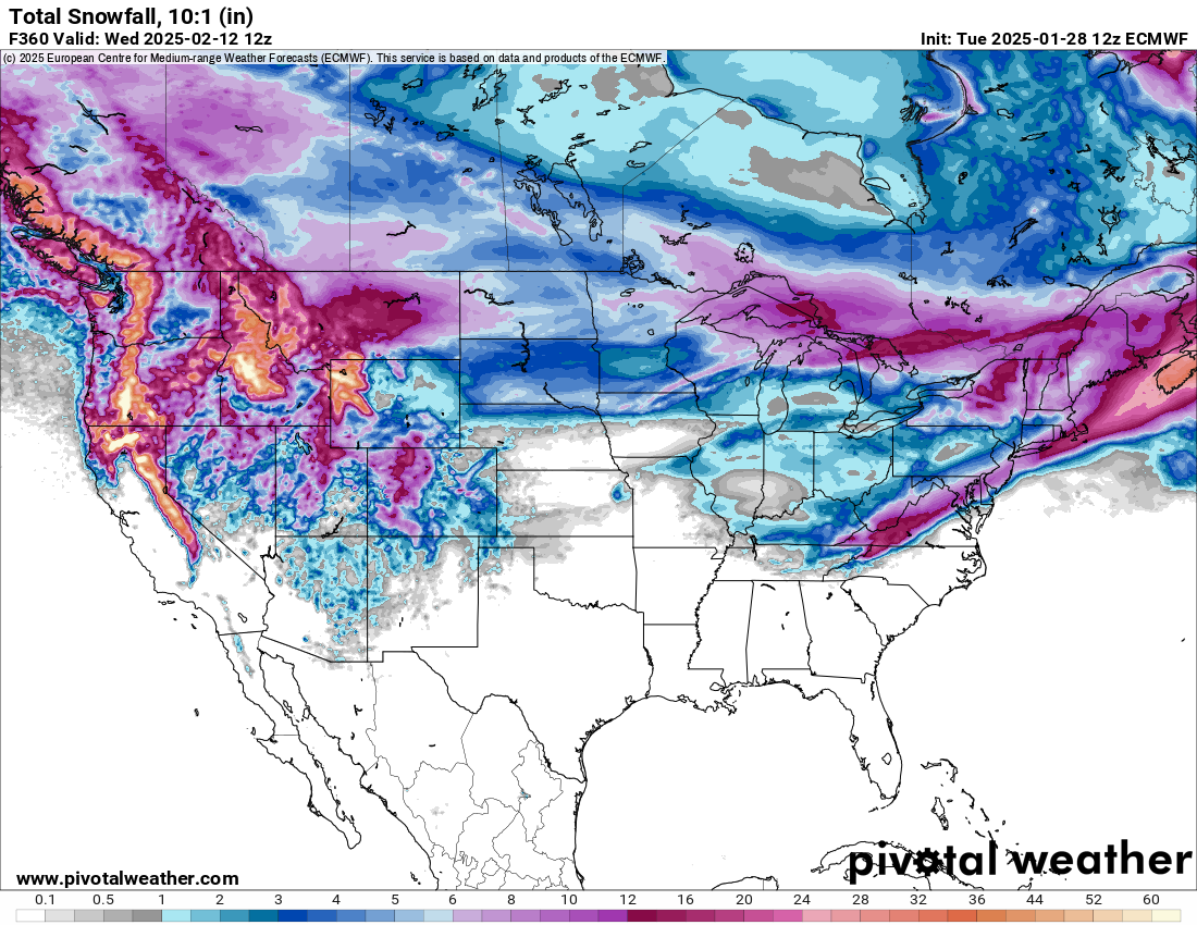
Right now I would go with the Euro solution as the most reasonable which is half as of 12Z of the GFS solution . GFS the last few runs has about 2 ft. plus for the region on avg through 384 hours while the Euro is about half that.........BUT this is only potential and we could end up with much less especially the way this winter has played out thus far......
-
 3
3
-
-
8 minutes ago, BxEngine said:
Of course. Hes been here 20 years and still is optimistic to a fault…mostly because he cant read a damn map (sorry metsfan lol). But some people here act like we deserve great patterns and avg 100” a year. “Omg 3”? wake me up when its showing a foot”. Jesus christ. As a whole, our sub avg roughly between 25-40” with higher amounts further northwest. That means most years we wont get that because coastal storms giving us big events arent happening. But if you dont want to talk about a few inches here and there, or the cold snap (relative, still warm as hell comparatively but at least the damn ponds froze), why even bother having an account here? Its really really odd behavior. The literal 180 of metsfan.
This forum opened in November 2010 - a little over 14 years ago and wasn't the old forum called Eastern Weather ? Many of us were members there .Can't remember why that forum closed and this one was created - a history lesson please ?
-
1
-
-
2 hours ago, LibertyBell said:
no snow at all would also be a surprise, that's the point
The Euro total snowfall is reasonable IMO as compared to the GFS 2 feet of frozen snow.sleet

-
3
-
-
Growing confidence that there are a few models that are agreeing about a moderate frozen event mid- late week 3-6 on the 12Z Euro - IMO need a few more runs in a row too gain more confidence and if they still agree after Sunday nights 0Z run - its thread time if Walt agrees
-
2
-
-
The 12Z GFS outdid its usual self
-
1 hour ago, LibertyBell said:
I'm looking at temps in the 50s-60s, a short cool down that lasts 2-3 days with a snow event, and then back to the 50s-60s.
why don't you post some model guidance to back up your predictions ?
-
1
-
-
4 minutes ago, Brian5671 said:
We should all get enough to wash away the road salt at least
right now with this very light rain your tires are washing it up to the underside of your vehicle - also radar returns to the south are moving mainly eastward with minimal northward progress and little precip directly to our west - main batch of heavier precip is south of DC......
-
 1
1
-
-
1 hour ago, eduggs said:
LR guidance looking like dog shit again. Snow threat tracking sure has been painful these past few winters.
The 0Z Euro is more active and precip interacts with the cold air here

-
25 minutes ago, brooklynwx99 said:
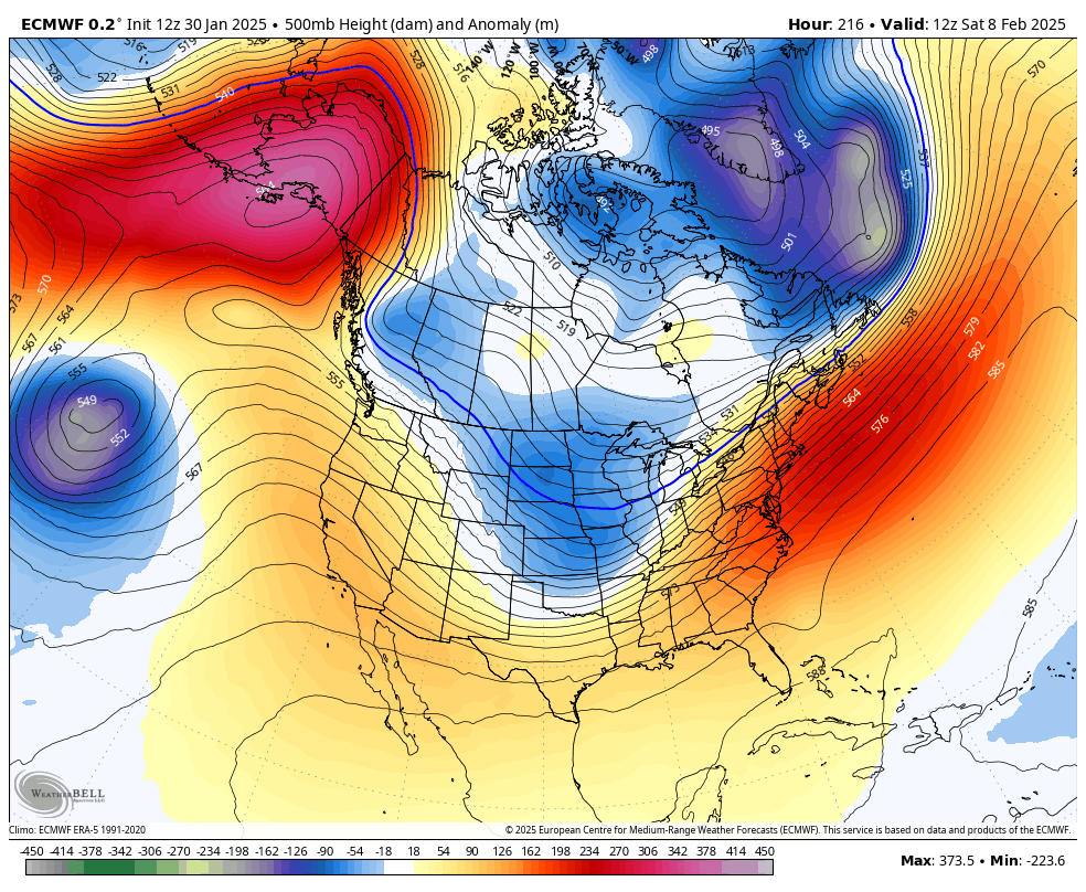
just for the sake of argument, the ECMWF shows why 500mb ridges in the east along with a -EPO don't really portend a lack of wintry weather... the E US is actually under an anomalous 500mb ridge here, but there's enough HP to the north to lock in colder air and lead to a heavy snow event
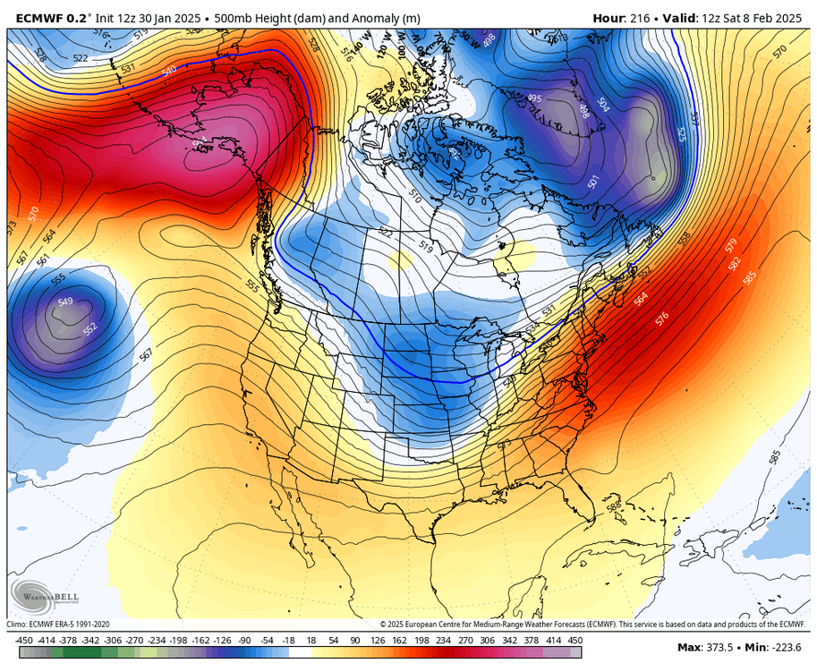

This is actually similar to what happened with the January 19th storm - a wave of LP develops on the slowly moving cold front - the GFS also shows it like I posted a few posts up BUT a day earlier
-
1
-
1
-
-
The 12Z Canadian doesn't push the arctic front as far south the first week and the pattern becomes more active without suppression

-
1
-
 1
1
-
-
February is beginning to look alot like January on the 12Z GFS - cold and dry with suppression the first 1/3rd of the month at least little snowfall but chance of a coastal the 7th on a slow moving front - sound familiar ?


-
1
-
-
32 minutes ago, Brian5671 said:
We finally got the cold-but no Southern Jet and the northern jet is just too fast for anything to amplify...can't even get a good cutter!
will be interesting how much rain we actually receive on Friday
-
2 hours ago, MJO812 said:
Models keep showing a possible storm next week. Could be wintry.
Only the GFS now for next week BUT the Euro shows it a week later - IMO good idea not to start any new threads till the GFS, Canadian and Euro or at least 2 out of 3 agree on something with accumulating snow and their ensembles for at least a few runs in a row....
-
2
-
-
5 hours ago, wdrag said:
No headline change yet. Upper low now being modeled to lose its structure slower as it crosses PA Fri night.
Next short wave seems to have neg tilt for Sunday evening.
I guess I'm not convinced of the sfc low tracking north of us Fri-Fri night and 18z/28 EC op trying for some snow Sun night-Mon down to I80. I just want to make sure before I give it up in the headline, that its really no chance.
Will rereview at 730A Wednesday.
this event is not exactly a drought buster as it will barely deliver enough precip in the metro to get rid of the remaining salt on the road ( don't be surprised if some towns put down more ice melter spray prior to the light storm if temps are forecasted to be close to freezing) but after friday there will be only a few piles of hard frozen snow/ice left
-
1
-
-
Next week is now going to feature our next storm threat/thread as several models including the 0Z Euro are showing an east coast storm sometime mid - late next week

-
1
-
1
-
 1
1
-
 1
1
-
-
3 hours ago, MJO812 said:
Yep we have a few shots
0Z Canadian

-
1
-
1
-
-
2 minutes ago, MJO812 said:
Maybe some snow Sunday
and again mid - later next week
-
1
-
2
-
-
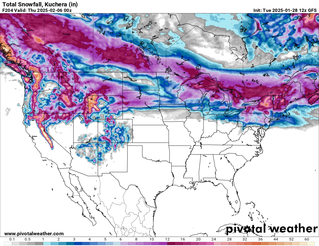
Fun times ahead 1st week of Feb
GFS Model – Total Snowfall (10:1 SLR) for Northeast U.S. | Tropical Tidbits
-
1
-
1
-
-
7 minutes ago, wdrag said:
After 2/3, doesn't 5H look above normal to very large positive anomaly, and consequently less chance of snow than what little is on the table the next 6 days.
I wont say this is it, but I enjoyed the cold and coming brief cold shots through this weekend. Wish it would have snowed more and maybe things will change, but to me it's looking like good timing via needle threading will be our best chance for a more than 4" snow into mid Feb for CP. Am I missing something?
-
1
-
1
-
-
There still is hope -lol
-
1
-
1
-
-
30 minutes ago, LibertyBell said:
It's very unsteady and not reliable. I think most people here would prefer having a floor of around 20 inches (that is no season with less than 20 inches of snow.)
that was my point - you are never going to get consistent average seasonal snowfall around here year to year - there are wide variations in year to year totals - always has been that way
-
3
-
-
1 hour ago, LibertyBell said:
You want to see real snow, go to the Poconos. Coastal areas aren't good for snow anymore. Right now there are major white out conditions happening in the Poconos with a big snow squall warning.
If you want snow, you need to get away from sea level.
until you get a few seasons in a row of above normal snowfall - go look at the record books - we go years in a row with below normal snowfall and the same with above normal.....
-
The 0Z Euro shows the later weekend storm passing to our north with no precip here

-
1
-
-
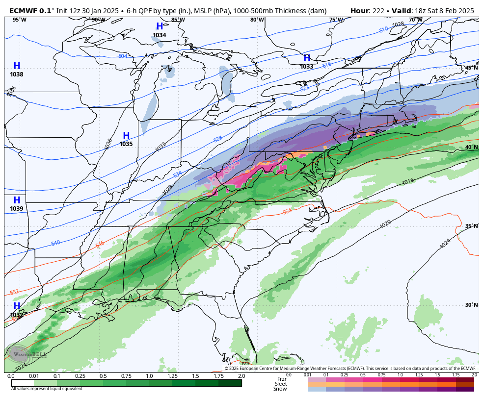
The OZ Euro starts the precip during the day Friday (31st) and ends it just after midnight the (1st) -all liquid here - storm is not suppressed much obviously

February 2025
in New York City Metro
Posted
0Z Euro is getting back to reality IMO
Models: ECMWF — Pivotal Weather