

NEG NAO
-
Posts
7,490 -
Joined
-
Last visited
Content Type
Profiles
Blogs
Forums
American Weather
Media Demo
Store
Gallery
Posts posted by NEG NAO
-
-
1 hour ago, MJO812 said:
Cmc and ukie are interesting for next weekend but let's see what happens when we get closer.
its amazing how different the GFS and Canadian are along the east coast next weekend GFS has no sign of a storm and Canadian does


-
 1
1
-
-
4 minutes ago, LibertyBell said:
I actually want to see if we can avoid 60 degrees during the entirety of astronomical winter, that might be the first time that's ever happened.
it would be welcomed though - can sit outside for awhile in the sun hopefully
-
 1
1
-
-
4 minutes ago, LibertyBell said:
In the 2010s yes, but not in the 2020s. This decade has been pretty bad for March snowfall (or snowfall in any month really.)
so far - BUT we are overdue for a snowy March
-
Just now, MJO812 said:
Some of these people just want winter to end. They aren't looking at anything .
I agree and also their warm biases during the winter
-
1
-
-
19 minutes ago, LibertyBell said:
I'm sure you understand that it's much easier to predict temperatures than it is to predict snowfall. Especially so on the margins (which Don also stated in an earlier post in this thread.) But even in the middle of winter it's much easier to predict temperatures than it is to predict snowfall. Snow is much more of an anomalous event than average temperatures are.
when you enter March predicting any weather event in the longer range becomes more difficult because its a changing of seasons - plus if you predict low 40's for a daytime high and it snows your prediction from 10 days prior will bust by 10 degrees at least
-
1
-
-
11 minutes ago, LibertyBell said:
No you can find them yourself and they will be a hell of a lot more accurate than this cartoonish snowfall map from the 6z GFS.
Even just going by climo for temps will be a lot more accurate than this.
There isn't going to be snow here for at least a week, 0% chance.
That map has no snow on it for a week in NYC if you run it from day 1 - what makes 10 day temperature maps more accurate than the GFS long range snow map ? There have never been any busts ? Never any differences in individual models ?
-
13 minutes ago, LibertyBell said:
long range maps, plus 40s is normal for this time of year so it's not a tough forecast to make.
can you post some long range maps to prove your point ? Here's a snow map in the mean time

-
2
-
 2
2
-
-
56 minutes ago, LibertyBell said:
Probably low 50s, the following week looks colder (especially March 2nd) and then it bounces back to the 40s again a few days later so a short but sharp cold shot?
On a positive note, today was the first morning I noticed the sky getting brighter before 6 am here!
how can you predict the daily temps being in the 40's over 10 days in advance ?
-
1 hour ago, SnoSki14 said:
Coming week looks nice and toasty, flirting with 60F on Tuesday.
Very dry however, that's not great. Following week looks a lot wetter though.
if you are going to make statements that contradict what the NWS is predicting at least try and back it up with some evidence
-
5 minutes ago, Stormlover74 said:
Imagine a 979 low and rain to northern VT?
.thumb.png.0c2ee2e04af5e9fe9468242f9dee7b70.png)
Can you imagine if that model is wrong ?

-
 1
1
-
1
-
-
1 hour ago, Krs4Lfe said:
Looks like we'll be heading to 40s and 50s by end of next week. Starting off meteorological spring strong. We'll need some colder air in order to work out a marginal event down here. If we're finished with snow, NYC's amount is 16" lower than the average.
how do you get 40's and 50's from this on March 1 ?


-
 1
1
-
-
27 minutes ago, Allsnow said:
Coating
last of the season?
yes its already Feb 20
-
17 minutes ago, NEG NAO said:
Sunshine Likely - 70% chance
Tonight 2 - 6 flakes Likely . Chance of flakes 70 %
They used to call the TV Show Seinfeld "The show about nothing " the lasted storm thread was 59 pages about nothing" in NYC metro.. Amazing how all of us including Red Taggers and other color taggers and even the NWS get suckered in most times to believing long range range models..... usually it is the GFS leading the way but this time was the EURO
-
1
-
1
-
-
9 minutes ago, LibertyBell said:
a blue skies blizzard?
it's completely clear right now with blue skies and the only thing limiting visibility is the blinding sunshine.....
Sunshine Likely - 70% chance
-
2
-
1
-
-
5 minutes ago, weatherpruf said:
But we've been moisture starved for months, and that continues.
huh ? precip is above normal this month at Central Park after this past weekend storm and another storm next week
-
1
-
-
3 minutes ago, RU848789 said:
I get the disappointment in the season, but at the same time I've had 12 measurable snowfalls totaling 16", albeit 4 of them were <1" and 6 of them were 1-1.5", with only 2 of them in the 3-4" range - but all of them made it look wintry for at least a few hours to a day. Have had at least a bit of snow coverage much of the winter post 12/20, as it's been cold, preserving the small snowfalls. If we can get another 1" tomorrow and a couple of 3-4" storms before the winter is over, I'm up to about normal.
that has to be some sort of record -- 12 snowfalls worth 16 inches........in one season
-
1
-
1
-
-
4 minutes ago, eduggs said:
NMB9 showing the extreme (weenie) solution.
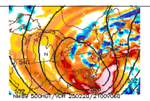
IMO I don't think we will have a good handle on this and how this is going to move up along the coast until the energy is transferred from the Gulf to the southeast coast and the precip field develops and how much territory it fills and the movement of it - and exactly how the upper low is behaving..........
-
3
-
1
-
1
-
-
8 minutes ago, donsutherland1 said:
If an IVT forms, it would provide a localized snow event. Most of the NYC area would not likely benefit. The GGEM has a more prominent IVT signal than the GFS, but we'll have to see whether later guidance shows it and, if so, where it forms.
The NAM had far more than a Norlun trough. It tracked the storm north and west of the other guidance producing a larger snowfall across the region. Its current idea of the pattern is an outlier. The 12z GGEM has reaffirmed the other guidance. We'll see what the UKMET and ECMWF show a little later. But I think at this time, one can have good confidence that the NAM's scenario is a low probability one.
Yes the NAM is based on the LP being dragged west by the upper low - but in this scenario even if that doesn't happen there is still more then 1 way such as the Norlun possibilities or just the strong dynamic upper low passing overhead of getting accumulating snow in NYC metro - I think Walts idea previously of 2 -6 inches powder is still on the table IMO.....
-
1
-
1
-
-
8 minutes ago, donsutherland1 said:
The 12z 12 km NAM is an outlier. The 3 km version, along with the RGEM and GFS remain in good agreement with the storm's focus. Flurries or a period of light snow remain possible in the New York City area and surrounding region (probably 0.5" or less in NYC). But the 3"+ amount shown on the 12km NAM is very unlikely given that the model is on its own with a track to the north and west of the other guidance.
its an outlier right now but what if other models start bringing the storm back west just a hundred miles ??? makes a big difference especially close to NYC - still plenty of time for adjustments and as I mentioned last night the models have handled this storm poorly since last week also norlun trough and strong upper low has to be considered -- Norluns are difficult to predict in advance
-
1
-
2
-
-
IMO anyone who thinks they have a handle on this situation right now ___ _____ ______ ____ ___ ___fill in the blanks
-
1
-
-
21 minutes ago, wdrag said:
One thing that is somewhat evident to me in FEB... eastern LI has been doing RELATIVELY well. Seems like that may be the case again.
Watching waffling minor changes in global ensemble qpf so noise for now.
This is the point at around 66 hours NYC metro has the opportunity of a period of steady snow as the northern stream feature passes overhead - unfortunately this northern upper level feature doesn't phase with the southern branch until too far offshore - all of the heavier snow down in the southern mid-atlantic is being caused by a strong southern upper level system

-
 1
1
-
-
8 minutes ago, RU848789 said:
This is the 19Z BOM I'm sure he was referring to at 7 pm...I would kill for that, lol, but I'm sure it's heavily weighted towards the NAM and SREFs, which are also bullish. The NWS often follows the BOM at least early on, but clearly they are not right now, with less snow forecast, which is understandable with nada from the GFS, UK, CMC, etc (other than the 1/2" or so now showing up on some of the models for nearly everyone, presumably due to the upper level low).

there will be changes in that snowfall map one way or the other since this storm is so disorganized and questions about exactly where the energy will be transferred to along the east coast and many variables regarding intensity and track and the size of the precip field and the chance of a westward expansion of any norlun trough that develops which could expand the precip field further west then modeled considering the models since last week have had a weak handle on this whole situation and the storm is still a little more than 2 days from reaching here and is in the early development stages out west and will be transferring energy at different points as it moves into the Gulf region and off along the southeast coast - impossible for any guidance to be accurate at this point IMO
-
1
-
-
5 hours ago, wdrag said:
7PM 2/17/25: adjusted headline to narrow the timing goal post of what has become a much more uncertain event since initially proposed...even with the option of no snow. This despite a strong short wave passage Thursday evening. The GEFS still closes a low through PA while the EPS has weakened to an open - less ominous progressive short wave trough with no significant 850 MB onshore circulation. The 15z/17 SREF, 18z/17 NAM and 12z/17 JMA are the only models with any significant hope for snow as the globals have largely faded southeast since thread inception. The apparently lagged average BOM and 12z/17 WPC still maintain an opportunity for a period of light snow (1/2-4" nw to se on the BOM).
Which locations are NW to SE since there are many differing opinions here regarding that ?
-
1
-
-
13 minutes ago, MJO812 said:

50 mile adjustment north and west = MECS in NYC metro --- lets see how many EPS members are 50 miles north and west of the OP
-
1
-
1
-
.png.0485aa227042b57db619b09fa4623fff.png)

March 2025
in New York City Metro
Posted
like any other possible snow event - need more then 1 model and at least 1 models ensemble members consistent with it for at least a couple of days to even consider it.......models are still arguing with each other and even with themselves run to run - but its still fun to post these model runs with blizzards - GFS is King of the long range imaginary Blizzards - what was weird about the storm a couple of weeks ago was the EURO was the first to show an imaginary Blizzard many days in advance..BUT the GFS did not