-
Posts
6,930 -
Joined
-
Last visited
Content Type
Profiles
Blogs
Forums
American Weather
Media Demo
Store
Gallery
Posts posted by NEG NAO
-
-
48 minutes ago, donsutherland1 said:
No. Central Park stands at 7.5" after 2.0". There could still be some minor additional accumulation when the final report is posted.
any guesses as to when or if they will get 2.5 inches more to avoid a record 2 seasons in a row below 10 inches ?
-
Just now, Stormlover74 said:
Yeah when I stepped outside I couldn't believe it was that much. I figured 4 or 5 eyeballing it. That's why you always need to get out there with the ruler
same here obviously - you could call this storm a bust for many but these systems are difficult to predict as Upton and MT. Holly were chasing their tails last night issuing winter storm warnings in now casting mode....
-
 1
1
-
-
Just now, winterwx21 said:
Crazy. Can't believe I got 8 inches here when we were only expecting a few. This winter went from being terrible to not bad in the snowfall department for our area this week.
these types of storms are very difficult to predict till the last few hours prior - we could have easily missed out on the heavy band....
-
 3
3
-
-
On 2/15/2024 at 8:22 AM, SBUWX23 said:
the big unknown is if snow growth isnt the best, if you are not dendrites the habit could lower your ratio even its cold. Temperature is only one part of the equation.
snow growth was fine at my location
-
 1
1
-
-
1 hour ago, weatherpruf said:
Is this a clipper? Never seen one produce yet since I've been following.
this is not a clipper its a weak mid- latitude cyclone - starting out in central rockies - it didn't originate in Canada
-
 1
1
-
-
Paying too much attention to the model fluctuations every 6 hours - most don't have a handle on this system........
-
 2
2
-
-
4 minutes ago, SnowGoose69 said:
As I said watch for jet dynamics to induce more snow in this event, even in areas which may be modeled to get little from the coastal. I suspect in this storm there will be a screw zone like last event, not for same reasons but lets take the 18Z RGEM as an example...obviously CNJ sees biggest amounts but I'd bet that places in NE PA/SE NY and NW CT there'd be some zone that gets like 4-5 inches while in between amounts are lower. It happens often in setups like this. The HRRR has notoriously nailed those jet induced snow maxes, even from 36-48 out and indeed if you look at the 18Z run from 34-38 you see that somewhat with that band over PA with a screw zone of lighter echoes between...once the coastal takes over more it sort of loses the snow everywhere and that idea does need to be watched here, but if we get this to tick a bit north it won't matter much.
so in other words bust potential is higher then normal again for this event ?
-
5 minutes ago, Stormlover74 said:
The gfs and euro are now the 2 extremes. Naturally
And it's not like we can split the difference since one is literally nothing
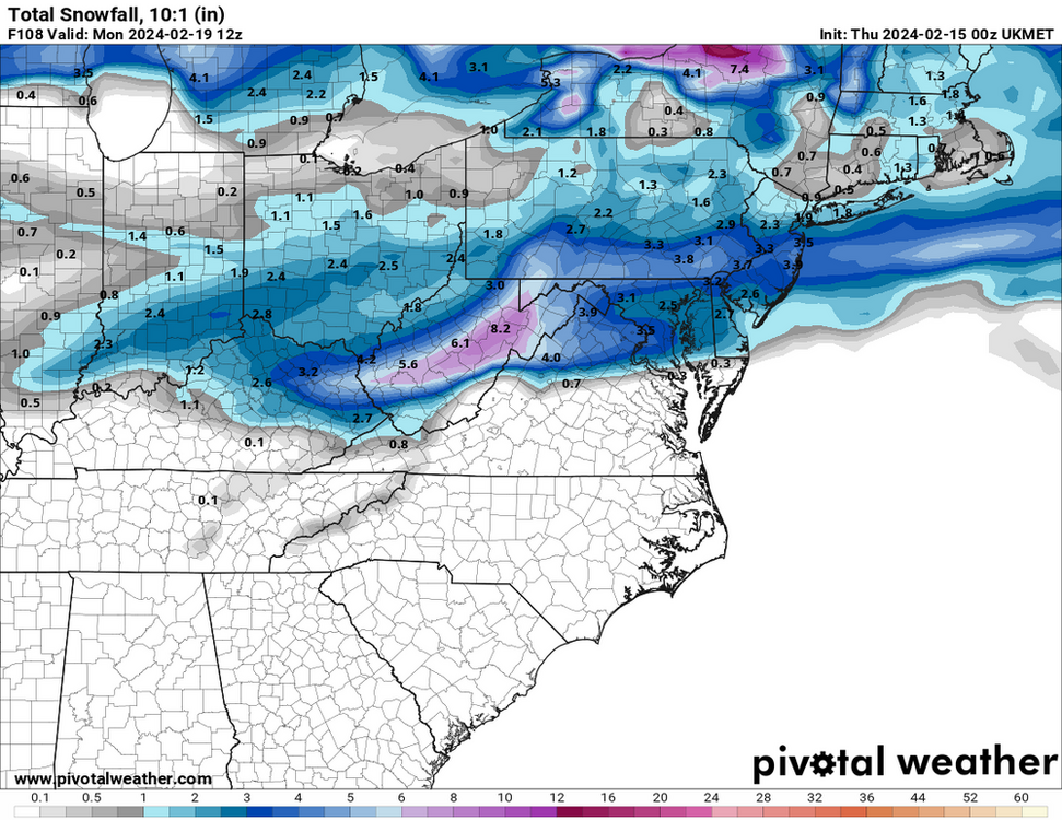
areas south of I-78 - 3-5 inches north of their 1 -3
-
 1
1
-
-
Just now, LibertyBell said:
what if you are at the same latitude as I-78 on the south shore of Long Island?
I am not sure you tell me ...........
-
Just now, SBUWX23 said:
try to look where omega is located, and see if it lines up with the -12 to -18 zone in the profile and it is saturated. That is also one piece of the puzzle. Snow habit is diverse, but that is one way to get an idea.
ok - keep us updated where that omega is located ?
-
Just now, Stormlover74 said:
They could actually have a higher ratio inside of the heavier banding south of 195
true if the heavier banding ends up there - not certain where the banding will occur as of now
-
Just now, SBUWX23 said:
the big unknown is if snow growth isnt the best, if you are not dendrites the habit could lower your ratio even its cold. Temperature is only one part of the equation.
how are you going to determine that in advance of the storm ?
-
6 minutes ago, Stormlover74 said:
I wouldn't necessarily expect that
just like it was safe to go with 10:1 the previous event ?- many of the individuals mentioning it are METS with a solid reputation.....temps will be in the 20's at the surface and cold enough aloft....places in south jersey might have closer to 10:1
-
12 minutes ago, MJO812 said:
Need more bumps
mainly If you are north of I-78 in NJ - central and south jersey are looking good now............
-
 3
3
-
-
13 minutes ago, Brasiluvsnow said:
Bump North baby Bump North and if you care to gain some moisture and strength along the way please feel free

This is a lower then normal impact event since it is happening on a Friday night into Saturday morning and traffic is much lighter with closed school and many business'. Potential of 2-4 and 3-5 IMO especially south of I-78 in NJ ...
-
 1
1
-
-
Curious as to why Walt thinks this is as short as a 4 hour and long as a 10 hour event ?? Uncertainty of speed and development of the system ????
-
3 minutes ago, DDweatherman said:
IMO the models are not taking into account the higher ratios possible ( just like they didn't account for the lower ratios of the previous storm) especially the further colder north you go in the precip field so some areas you can add up to 50% more to the totals displayed
-
with the higher than norm 10:1 ratios majority of guidance suggests this is a 2-4 or 3-5 inch IMO event south of I-78 in NJ down to at least DC and all the way to the beaches in NJ at least
-
 1
1
-
-
4 hours ago, wdrag said:
I love these spells of winter. Noting that it helps hold the snow cover out here. Continues beautiful. Was driving a patient in an ambulance at 5A over High Point - somewhat slippery roads in flurries, blowing snow and gusty Winds 3gusting 0 MPH. So different (relative calm in Newton-Sussex) once you get in the valleys and you dont realize how rough it can be.
down here in central NJ the snow cover is decreasing rapidly - down to an inch or so with some bare spots - by the time the weekend snow starts probably just patches of an inch or less will remain.........
-
 1
1
-
 1
1
-
-
1 hour ago, SBUWX23 said:
The nam can easily shift back north. Rgem is and it's consistent with its previous run
RGEM came slightly (about 20 miles north) at 0Z and 2M temps are in the 20's in most of metro so higher then normal ratio's - 2 -4 inches region wide possible on RGEM


-
 3
3
-
-
8 minutes ago, RU848789 said:
they play this ultra conservative game practically every storm - thats what they are instructed by their bosses to do as opposed to what the private sector or media is instructed to advertise........
-
 1
1
-
-
Just now, SBUWX23 said:
What do you expect them to do when guidance is spread
cover their rears
-
1 minute ago, winterwx21 said:
This NAM run actually started it out as a little rain on the leading edge before quickly changing it over to snow.
tend to doubt that will happen except far south jersey
-
of course Mt. Holly is going conservative again 1-2 inches


A wintry event likely I84 corridor Fri Feb 23 may involve small portions of the NYC subforum with some snow accumulation.
in New York City Metro
Posted
then why does the thread title say "likely" ?