

PB-99
-
Posts
973 -
Joined
-
Last visited
Content Type
Profiles
Blogs
Forums
American Weather
Media Demo
Store
Gallery
Posts posted by PB-99
-
-
This should put a wrap on the season.


-
 1
1
-
-
Looks right.

-
1
-
 1
1
-
 2
2
-
-
Can we have next years forecast now so I know which weather service subscriptions I can cancel.
Thanks in advance.
-
1
-
-
4 minutes ago, Isotherm said:
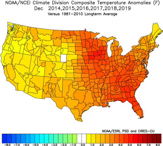
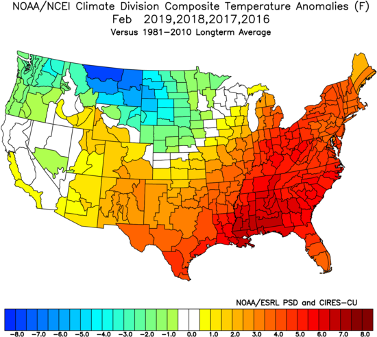
This winter has continued the theme of "stagnancy" - that is, absent novel forcing mechanisms, we maintain a similar set of indicators, and thus, z500 regimes tend to repeat. For example, the SSTA profile in the Atlantic has been quite similar since 2017, which has been reinforcing the humid/warm summer signal in the East. This winter featured many of the same indicators as 2018-19, and as a result, the mean storm track followed suit.
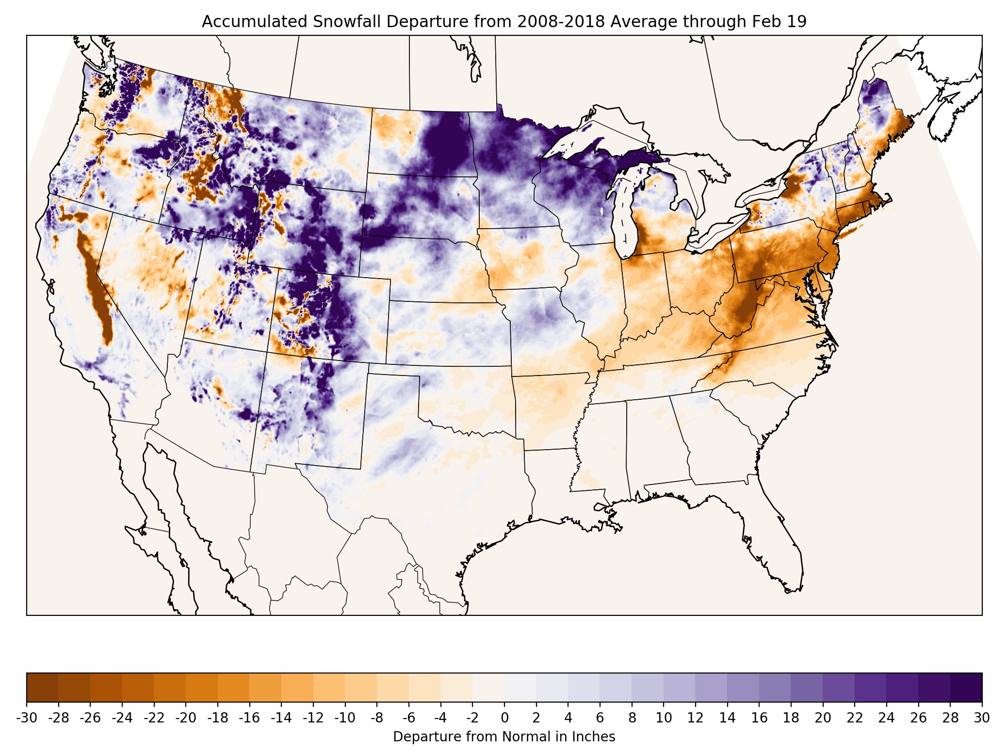
These snowfall departures with respect to normal have a base period of 2008-2018, but still impart the general picture of snowfall anomalies to date [h/t Eric Snodgrass].
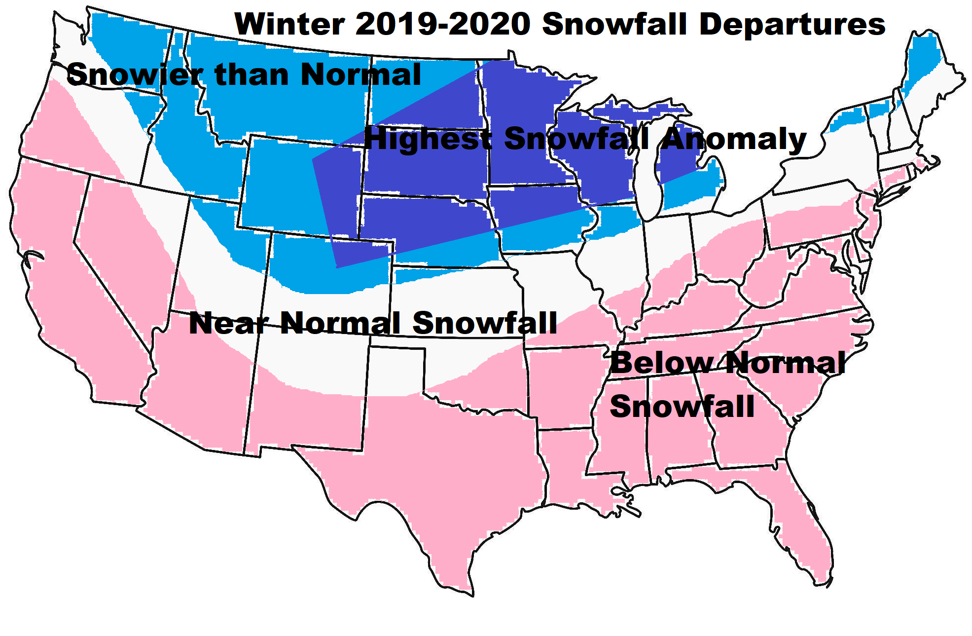
Underneath that image is my snowfall anomaly outlook for this winter. The season is not over yet, but I'm quite content to see the anomalies are highly congruous with my pre-season expectations. Upper-Mid-west and northern Maine jackpots.

GREAT FORECAST.
-
2
-
1
-
-
14 minutes ago, snowman19 said:
Yep. The airmass sucks. Among other big issues. This is a rain event again
Yep, the cold presses in behind

-
1
-
-
5 minutes ago, MJO812 said:
Low is too close to the coast. Thank god this is a million years away but we cant get lucky.
The placement is fine.

The B/L at this distance is a little too warm. ( which fits the winter )

-
2
-
-
If I had a $1 for every fake day 8 euro snowstorms shown this year , I would have a lot of $`s

-
2
-
-
6 minutes ago, snowman19 said:
Yep, it’s short lived and the models once again overdue the -EPO/+PNA in the long range, PAC jet rages back. Agreed about the -PDO
The trough wants to back up into the midsection, so you end up cold and dry for 5 days and then storms will cut.


Here is a 5 to 7 day transient cold dry shot


There is nothing but LP to your north which will allow storms to cut in the longer range.

-
1
-
-
Another WET Tuesday

-
1
-
-
34 minutes ago, snowman19 said:
Assuming we don’t loose it again, the first week of March is the “best” look we’ve seen since the beginning of December, which isn’t saying much at all. We are going to have to settle for a weaker -EPO than we had early last March. I have to believe this is transient with no -NAO or -AO blocks setting up to trap everything. How long the PAC stays ok is the other question. The PAC jet always seems to rage back and blast any transient EPO/PNA to pieces. Plus the SPV is still strong as hell....
Agreed.
Probably just a short window.
-
2
-
-
Good for S/C

-
1
-
-
19 minutes ago, ILoveWinter said:
Haven’t forecasted cold or snow shots >10d been somewhat or completely reversed between 5-10d? Do you see something here any different? Not a met so genuine question.
Makes sense this time

-
1
-
-
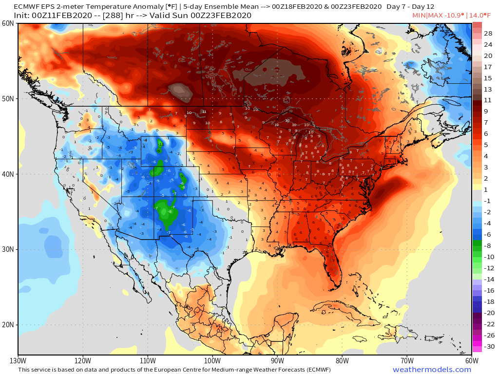
The cold will finally appear, the EPS is forecasting a week of -6 into the N/E by d 10.
The question will be, is it just another transient period and is there anything ( snow wise ) with it ?


-
1
-
-
Zip here over the next 15

-
2
-
-
44 minutes ago, Allsnow said:
Eps mean would make eastern North Carolina snow fans happy lol
Nice snow hole

-
1
-
-
Another rainer

-
2
-
 1
1
-
-
Dec and Feb have been non winter months over the last 4 years.
-
1
-
-
How bad is this winter ?
BN Day 5- 10 in mid FEB and not even a hint of snow.

Pretty big bust by the EPS for the 1st time this winter too.
-
2
-
-
15 hours ago, MJO812 said:
You and snowman cam stop tracking if you think it's over.
This winter is akin to a typical Met`s season . A B/N November ( when it didn`t matter ) and then a complete whiff the rest of the way.
Just like when the Met`s win in April and then end up being eliminated by the end of July.
@psv88, don`t get nasty lol.
-
2
-
-
3 minutes ago, snowman19 said:
Tick tok, tick tok.....
It`s been over for a few weeks now.
BAM was the 1st, they threw the towel in on Jan 12th. Many of us just as FEB began.
The EPS is saying expect 0 snow over the next 15 days.
The clock stop ticking a few weeks ago.
-
2
-
1
-
-
Euro Ensembles say there`s nothing through the end of FEB

-
2
-
-
Day 9 gets kicked


-
16 minutes ago, EastonSN+ said:
Want to learn, in that look would the cold air be trapped above the block? Or would the air under the block be good enough.
You would remove some of the PAC influence and you would create a ridge bridge over the top.
You would just need to shorten the wavelenghts like the day 10 Euro operational and some members of the ensembles see.
It would not be very cold - closer to N but LP would probably find it`s way S of you.
Day 10 Euro OP ( prob not real ) would be an example


These day 10 maps never verify, but it`s an example of what we would need for it to snow in a hostile pattern here.
-
1
-
1
-
-
Very nice call on the timing on the improvements at 500 man.
Let`s see if this L/R ridge bridge is real.


-
4
-
Mid to Long Range Threats
in New York City Metro
Posted
The " colder " is there.
But that`s early March now and not late Jan.
So 7 days of - 3 while Normal splits will be 42/32 is not frigid.
Oh well.