

PB-99
-
Posts
973 -
Joined
-
Last visited
Content Type
Profiles
Blogs
Forums
American Weather
Media Demo
Store
Gallery
Posts posted by PB-99
-
-
1 minute ago, Hitman said:
correction, yanks were not in the WS in 97, but won it in '99 and lost in '01
You`re right
I forgot about Arizona
-
19 minutes ago, Brian5671 said:
Amongst many factors, the warm water on the NW shore of Australia killed this year. Makes the MJO want to stay in the warm phases. Couple that with the super positive AO, +EPO and -NAO and we're toast.
I still like the 7th/ 8th time frame here.
I think we are probably coming out of a weak 3 or the null p
After that It`s another hostile period. I see that some like the 2nd half of Feb , but every time the MJO wants to take a tour in those warm phases , it takes it`s time.
And we are running out of exactly that.


-
In the Long Range,
HECS in my lifetime,
77, 78, 83, 96, 03, 06, 09, 10,16.
Yankees W/S wins and appearances
77, 78, ( lost in 82 ) 96, 98, 99, 2000, ( lost in 03 ) 09.
Vegas over / under Yankees is 101.5.
Simple, win the W/S this year and maybe we get a HECS next year, this year is done and has spit the bit.
15 days until Pitchers and Catchers so enjoy the FEB torch.
-
16 hours ago, Allsnow said:
Total can kick with the cold now as it starts after the 13th lol. If the -epo ridge sets up to far west it’s just going to dump the cold into the west. As you posted, great pattern for Chicago. We need to see where the -epo sets up or even materialize. That will write the story for February. I’m beginning to think it’s just not our year unfortunately. I will just hope for a early spring if that’s the case
Yeh man, it`s over. I had FEB as my month and waited 2 months for it. It`s not going to work out.

-
 2
2
-
 1
1
-
-
Just now, Snow88 said:
My friend in Utah has over 200 inches.
Alta averages 500 inches a year. You should see if they are hiring.
-
1
-
-
-
Great upper mid west pattern.

-
1
-
2
-
-
This is our one decent chance

-
3
-
1
-
-
We may have a decent chance on the 7th/8th then turns the lights out

-
1
-
-
1 hour ago, Snow88 said:

Looks good for upper mid west , not us.
If 93 changed to rain on the coast, what do you think that does displaced 500 miles west ?
He can`t be speaking about the E/C and I don`t think he is.
-
1 minute ago, Snow88 said:
Eps still has a storm signal just offshore. Plenty of members west of the op.


-
The model sees this on OBX so that`s a start , but that`s not where you want the jet aimed


-
17 minutes ago, SnowGoose69 said:
The UK/Icon solutions aren’t realistic in this pattern. This will either miss or it’ll phase with the NS and be a monster. I don’t really see any other possibility
The UKMET / ICON / JMA / NAVGEM / NAV ensembles all have a similar look. ( It`s not those 2 ) , however It`s a bad pattern / set up.
But it`s late Jan and you just need to deepen / close off in the right spot. ( It would have to be absolutely perfect we know ) .
Hat tip to Eric Webb for this good luck figuring out which one of the 4 Vorts phases and where.
It`s why the models will have a hard time seeing it, let alone close in on a forecast. It is hard enough to snow on the coast with a good set up.

-
2
-
 1
1
-
-
1 minute ago, Allsnow said:
I agree. As I mentioned a week ago, that timeframe holds the most promise.
You will have a - EPO and LP/ LP`s running along an Arctic Boundary.
Those work here.
-
1
-
-
6 minutes ago, Snow88 said:
How is this pattern bad ?
A strong storm would be good for the area. People always worry everytime we track Miller A storms. It's hilarious..
It's all about timing
The H is moving off, not building in. You will need to get kicked east by GL LP and deepen in the perfect spot just to cool the column.
That`s not easy Anth, this is not coming into a cold dome of air / and or blocking.
It`s not an easy pattern for the coast at all.
-
Just now, Snow88 said:
Better improvement from 0z. Its not going to take much to get a good snowstorm this weekend.
Anth, it has to be perfect in this pattern.
Seriously.
-
1
-
1
-
-
5 minutes ago, snowman19 said:
@bluewave Pointed this out yesterday, you have a raging fast, record PAC jet circling almost the entire globe, blasting right into the west coast. Any +PNA that tries to form can’t sustain itself, that strong jet just crashes right into it and knocks it down as fast as it pops up
Luckily that`s gone by day 11.
The flow buckles as the heights rise near the Aleutians.
The flow has Arctic influence not Pacific after day 10.


-
4
-
-
That L in the lakes is actually helping kick this to the BM. The timing of that feature is important, too slow and LP hugs without blocking, too fast and it punts it OTS.
I don`t look at the lakes low as a 100 % negative.
You can all S stream in late Jan, you just need it to deepen in the right spot.
It`s just a very dicey set up thought and it all has to go right.
And when was the last time that happened !
-
9 MB`s in 6 hours.
You just need that to happen 6 hours earlier.
-
Posted these desired fixes away about 30 minutes ago and was really my 1st stab at this one because of a SW getting caught in an overall pattern.
I want to erase the energy hanging on its backside.
I want to push the heights into S Central Canada which would allow the heights to back around and up the EC and allow the backside energy to dive in and consolidate on Hatteras and allow the heights to rise on the east coast.
Yes it's close, but it's also close to adjusting and escaping.
The models have moved away from the big phase and that is what is needed for this to work.
So we want to start seeing more robust LP.
Again I haven't been definitive on this one because it's just not clear to me yet.

-
1
-
-
-
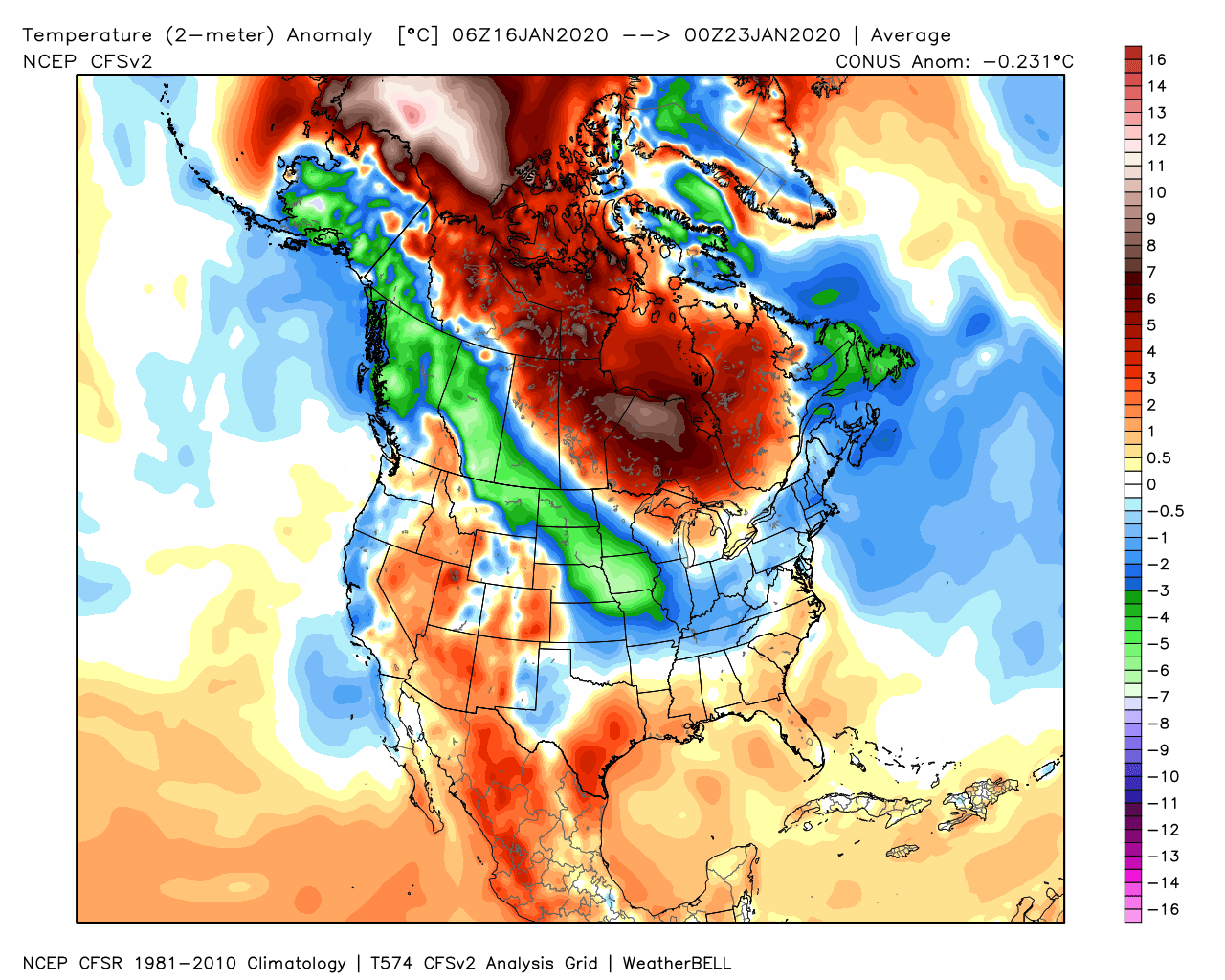
4 hours ago, bluewave said:
NYC is currently the 9th warmest January with a week to go.
Time Series Summary for NY CITY CENTRAL PARK, NY - Month of Jan
Click column heading to sort ascending, click again to sort descending.RankYearMean Avg TemperatureMissing Count1 1932 43.2 0 2 1990 41.4 0 - 1950 41.4 0 3 2006 40.9 0 4 1913 40.8 0 5 1937 40.2 0 - 1933 40.2 0 6 1998 40.0 0 7 2002 39.9 0 8 1880 39.2 0 9 2020 39.0 8 10 1949 38.6 0 You would prob be near the top 5 if this week did not happen.
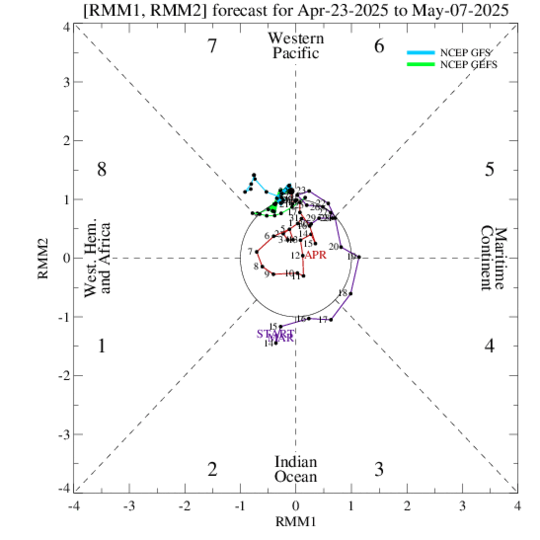
Got the p7 response without a lag.

-
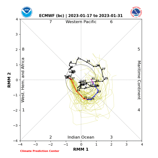
The big news here is TPV is moving away from Alaska and the deepest Negative is over the Eastern US.
The Kelvin in p6 dies off then the models may be taking the MJO back out near 1 and 2.
Can we get that Neg to swing into that trough off the WC, deepen and push those Heights back towards Alaska ?

The Canadian sees the ridge and that would finally force Arctic air into the pattern.

As far as day 10 , it`s track dependent , we could snow with PAC air the pattern because of the Late Jan, Early Feb time frame. However we would need a just east of the BM track to achieve that.
Here are the last 7 days, we did correct to slightly BN regime even though the air has been Polar Pacific. ( The 16th is warm +9 and skews that ) .
So the air mass is not putrid , just not well BN and you could snow on the right track with this
I would really wait until I see those maps 10 days out, these day 15 maps look very good but can not be trusted yet.
-
2
-
-
Can`t get any closer to p8 than that
Verification for the previous 7 days 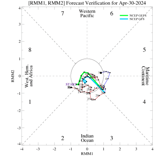
The GFS gets this into p8 for a day.
So let`s see if that happens and that idea was at least right as the wave is collapsing.
They agree on the next 7 days that we are in the middle of the Null p


Mid to Long Range Threats
in New York City Metro
Posted
I prob should have gone back to top NYC snowstorms 41 47 ( 60 lost ) 61