PB-99
-
Posts
973 -
Joined
-
Last visited
Content Type
Profiles
Blogs
Forums
American Weather
Media Demo
Store
Gallery
Everything posted by PB-99
-
Dam you.
-
I need that Edison cell to cut SE
-
The training down near Philly is intense.
-
Life threatening for sure.
-
Flash Flood Emergency out in N Philly.
-
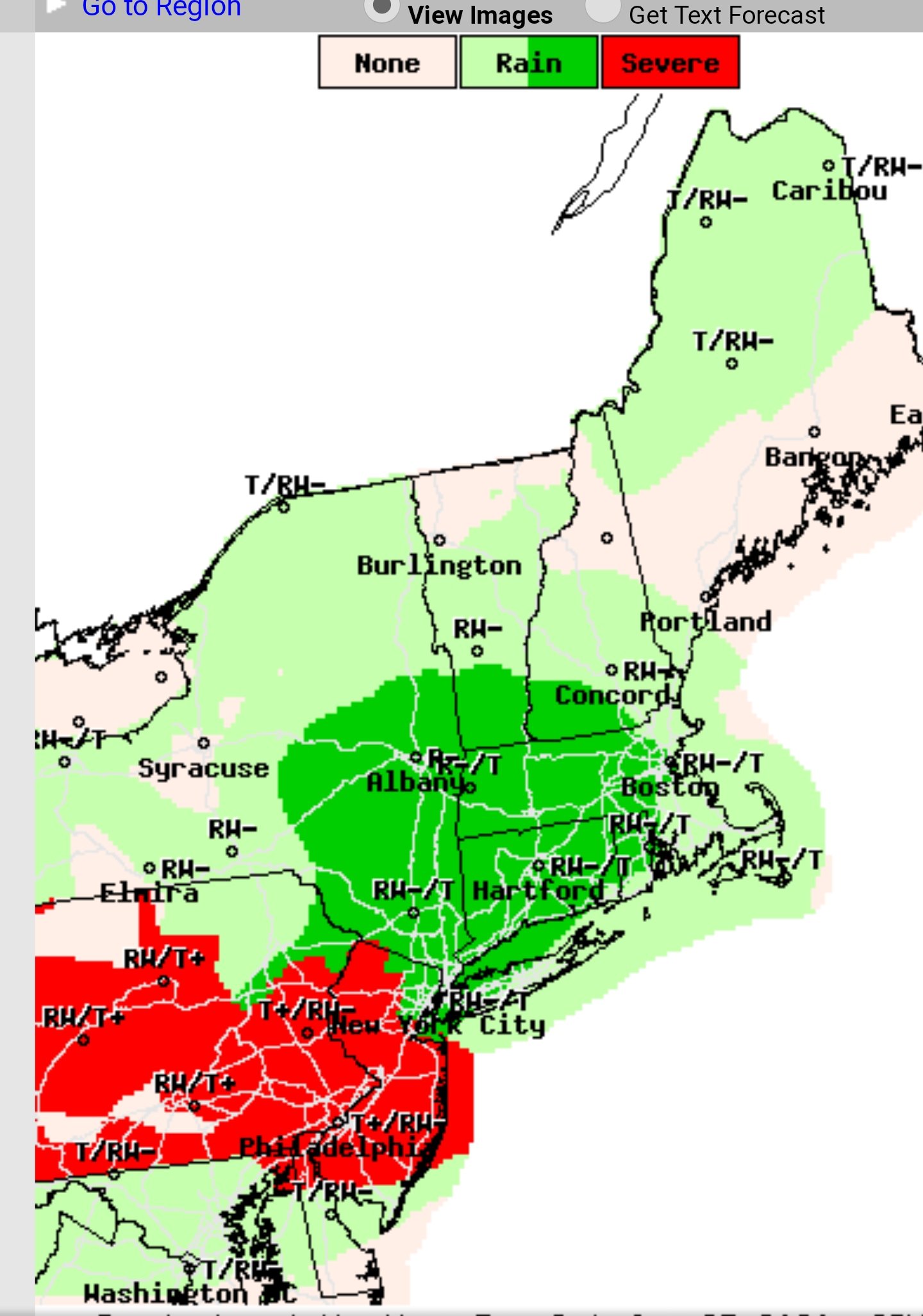
Severe Weather Statement Severe Weather Statement National Weather Service Mount Holly NJ 241 PM EDT Mon Jul 6 2020 NJC023-025-029-061915- /O.CON.KPHI.SV.W.0109.000000T0000Z-200706T1915Z/ Ocean NJ-Monmouth NJ-Middlesex NJ- 241 PM EDT Mon Jul 6 2020 ...A SEVERE THUNDERSTORM WARNING REMAINS IN EFFECT UNTIL 315 PM EDT FOR NORTHEASTERN OCEAN...SOUTHEASTERN MONMOUTH AND SOUTH CENTRAL MIDDLESEX COUNTIES... At 240 PM EDT, severe thunderstorms were located along a line extending from Marlboro to Adelphia to near Lakewood to Old Halfway, moving east at 30 mph. HAZARD...60 mph wind gusts and quarter size hail. SOURCE...Public. IMPACT...Minor damage to vehicles is possible. Wind damage to roofs, siding, trees, and power lines is possible. Locations impacted include... Toms River, Long Branch, Asbury Park, Lakewood, Jackson, Howell, Manalapan, Tinton Falls, Beachwood, Manasquan, Point Pleasant Beach, Seaside Heights, Lakehurst, Farmingdale, Mantoloking, Allenwood, East Freehold, West Freehold, Adelphia and Vista Center. This includes the following highways... Interstate 195 in New Jersey between mile markers 21 and 34. Garden State Parkway between mile markers 73 and 105. PRECAUTIONARY/PREPAREDNESS ACTIONS... For your protection move to an interior room on the lowest floor of a building. Frequent cloud to ground lightning is occurring with these storms. Move indoors immediately. Lightning is one of nature`s leading killers. Remember, if you can hear thunder, you are close enough to be struck by lightning. && LAT...LON 4027 7397 4007 7403 3980 7406 3984 7443 3987 7444 4015 7436 4030 7444 TIME...MOT...LOC 1840Z 252DEG 26KT 4032 7424 4022 7422 4007 7425 3987 7442 HAIL...1.00IN
-
N edge into Monmouth County.
-
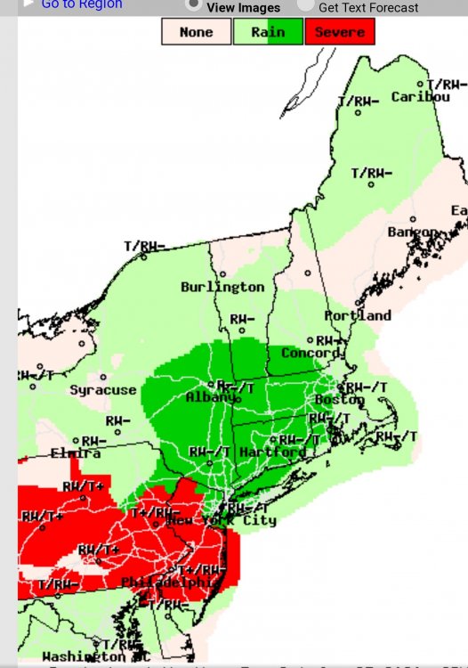
Yeh, you can see the Cape advancing to 78 ish. Even the 3k is to the Driscoll too. Maybe a few sneak into the lower boroughs ?
-
July 2020 General Discussions & Observations Thread
PB-99 replied to Rtd208's topic in New York City Metro
3K NAM and HRRR looks active tomorrow for Monmouth County. -
Let's all agree to keep politics out of here. The 1st one to wade into a non informative discussion goes. I am not pointing to anyone but this was one of the best cohesive disco's in a long time and it's gone. I know the adults in here can police this. This has had many turns and some like me in late February still weren't sure what this was. Now my position flipped 6 to 7 weeks ago and I am glad it did. I would really like to see us get to a resolution, I think the people who have been informative throughout deserve that.
-
Whatever you guys have decided will be respected. I hope all of you stay safe. There's some great convalescent plasma and vaccine work going on. Let's hope we get there fast.
-
Understood. I thought overall it was such an informative thread with really important information during this time. I was looking forward to the day we got a breakthrough in either a treatment and/or a vaccine. I think after all the hard work over the months by so many that it would have been a nice payoff for all those that kept it above the fray. Thanks for having me.
-
All that great content just got flushed , so many contributions. Couldn't move it to the Science thread ? As an outsider I wanted to thank you guys for having me but I just wish some would reconsider.
-
-
June 2020 General Discussions & Observations Thread
PB-99 replied to Rtd208's topic in New York City Metro
The pool is heated and there isn't a cloud in the sky. Doesn't feel like 75 in the sun. -
June 2020 General Discussions & Observations Thread
PB-99 replied to Rtd208's topic in New York City Metro
Pouring here at the office in Red Bank. -
June 2020 General Discussions & Observations Thread
PB-99 replied to Rtd208's topic in New York City Metro
1.35 inches of rain so far and just pouring here. Colts Neck. -
June 2020 General Discussions & Observations Thread
PB-99 replied to Rtd208's topic in New York City Metro
The 1st cluster moves SW to NE, just not sure how far N, but I would not be shocked if that ticked NE. Then the 2nd line weaker could fire up on the back side. -
June 2020 General Discussions & Observations Thread
PB-99 replied to Rtd208's topic in New York City Metro
-
June 2020 General Discussions & Observations Thread
PB-99 replied to Rtd208's topic in New York City Metro
-
June 2020 General Discussions & Observations Thread
PB-99 replied to Rtd208's topic in New York City Metro
-
June 2020 General Discussions & Observations Thread
PB-99 replied to Rtd208's topic in New York City Metro
-
June 2020 General Discussions & Observations Thread
PB-99 replied to Rtd208's topic in New York City Metro
Lightning just off to my west and the line is heading towards me in Colts Neck. -
June 2020 General Discussions & Observations Thread
PB-99 replied to Rtd208's topic in New York City Metro