PB-99
-
Posts
973 -
Joined
-
Last visited
Content Type
Profiles
Blogs
Forums
American Weather
Media Demo
Store
Gallery
Everything posted by PB-99
-
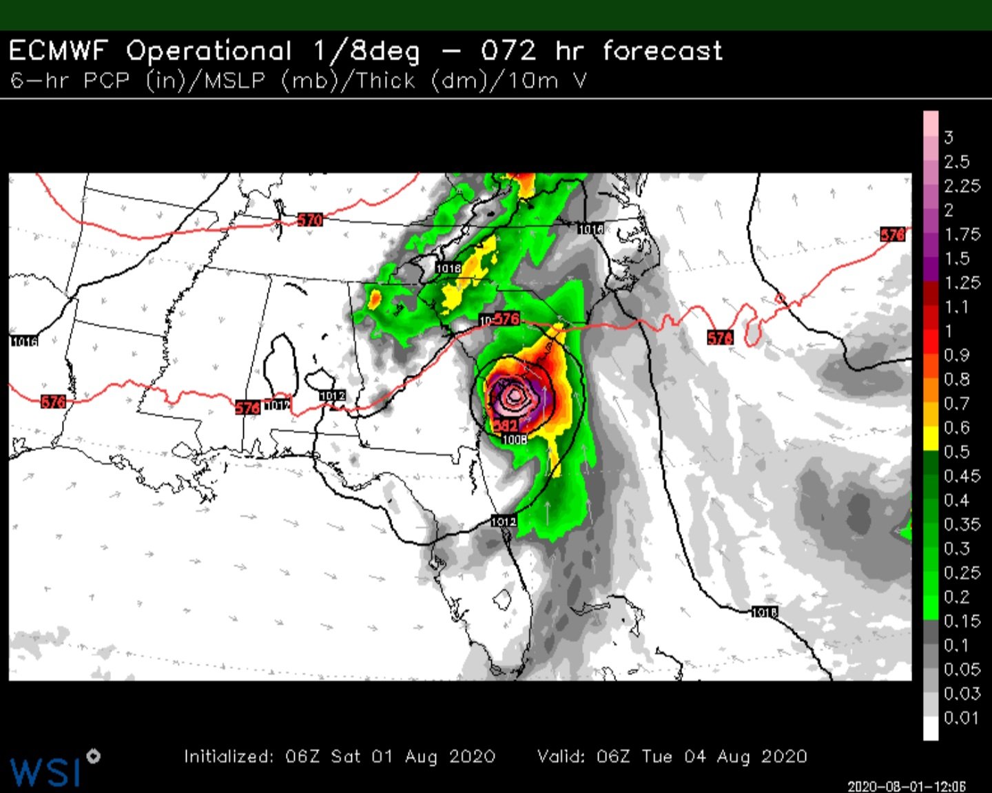
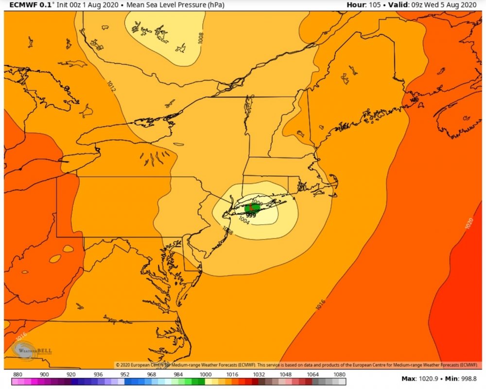
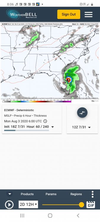
A few tornadoes will be possible from the Virginia Tidewater into New England Tuesday into Tuesday night, in association with Isaias. Scattered severe thunderstorms capable of producing large hail and damaging winds may also occur across portions of the northern and central Plains. ...Eastern North Carolina to New England... Latest forecast from the National Hurricane Center indicates that Isaias should be located over far northeastern NC and southeastern VA at the start of the period Tuesday morning. Isaias should accelerate northeastward along the Mid-Atlantic Coast and into New England through the period as it becomes absorbed within an upper-level trough over the eastern CONUS. A rather strong low-level flow field (60-70+ kt at 850 mb) will be present in the eastern half of Isaias' circulation, which will aid in substantial low-level hodograph curvature/enhancement. The best prospect for weak destabilization (MLCAPE 250-1000 J/kg) should exist along/near the Mid-Atlantic to southern New England Coast, where surface dewpoints should increase into the low to perhaps mid 70s through Tuesday evening. Given the very favorable low-level shear, primary concern will be a few tornadoes with any low-topped cells in outer rain bands along/east of the center of Isaias' circulation. Confidence has increased enough in the Isaias' track and potential for modest diurnal destabilization along/near the coast to include 5% tornado probabilities and a Slight Risk from the VA Tidewater region northeastward into southern New England. Eventually, the strong low-level shear should become displaced to the north of even weak inland destabilization across NH and ME by late Tuesday night. This should result in a gradual lessening of the isolated tornado threat with northward extent across New England.
-
A potential 80 mph gust, a spin up and 5 inches of rain in spots makes for a wide spread severe day.
- 1,530 replies
-
- 4
-

-

-
- heavy rain
- rip current
- (and 1 more)
-
You cut the euro by 25% and it`s damaging. The UKMET winds are off the charts, reduce this by 30% and it`s damaging. I was chided 3 days ago at thinking 100 mph gusts were possible on LI, now I am really looking for someone to record an 80 mph gust somewhere on the coast. And that`s close enough.
- 1,530 replies
-
- 3
-
-
- heavy rain
- rip current
- (and 1 more)
-
UKMET winds are stronger.
-
The jet was always taking this NNE with the WAR sitting there.
- 1,530 replies
-
- 1
-
-
- heavy rain
- rip current
- (and 1 more)
-
I am looking for an 80 mph wind gust show up on LI.
-
Goes back to a weak 1. A half of foot in rain in spots will be wild
- 1,530 replies
-
- 1
-
-
- heavy rain
- rip current
- (and 1 more)
-
Thought it was going to be well away from DR and Cuba decent. That didn't happen.
- 1,530 replies
-
- 1
-
-
- heavy rain
- rip current
- (and 1 more)
-
I really thorought a 2 was a layup by now over that 29c water. Bust. I will take my 5 inches of rain and root for a spin up tomorrow and Tuesday. Looks like 2 very active days coming up.
- 1,530 replies
-
- 1
-
-
- heavy rain
- rip current
- (and 1 more)
-
The Euro has for the most part hinted at this track for several days. It did take it west for a few runs, but it has been on the idea of the center crossing LI.
- 1,530 replies
-
- 1
-
-
- heavy rain
- rip current
- (and 1 more)
-
Close to Floyd, closer to the Florida coast but then right on up.
-
East of N Florida at hour 72.
-
18z east of 12z
-
Speaking of the Euro, last recon had this at 985, where's the Euro at 12z during this time, between 995 and 1000 ?
-
So it's model bias that he didn't correct. He doesn't overestimate, he just doesn't adjust for the error. I bet the same can be said at 2m in the winter
-
Recon down to 985.
-
Which leads me to believe it`s a ECMWF issue and just gets caught up in the coding. The snow ratio map issues crosses over even into Levi`s site and no one really uses them to forecast. I would love to see a 10m wind gust chart from another algo from yesterday, pivotal etc and see how far off Ryan was with a 120 max gust S of LI. According to him he is just using the soundings. But Forky could be right, I just want to see how far off he was/ is.
-
That`s known and those 10 to 1 maps have been wrong for 7 years. Same goes for TT. But I am talking about his gusts maps, he says his algo are the related soundings. So I am just asking do you have another 12z max wind gust map from 12z yesterday from a diff algo to show his soundings are off in any way. Happy not to use corrupt output, but Ryan says those are the soundings .
-
Are his LE maps B/S as well ?
-
Not calling you a liar, but do you have another max wind gust map from yesterday`s 12z run of another algo that shows that ? If that's the case, it will not be used.
-
Totally different system in just 24 hours on the Euro 24 hours ago 20 mb difference, different track, yields a different outcome further N. AWT.
-
Only the model did.