

DanLarsen34
-
Posts
514 -
Joined
-
Last visited
Content Type
Profiles
Blogs
Forums
American Weather
Media Demo
Store
Gallery
Posts posted by DanLarsen34
-
-
1 minute ago, TampaTwo said:
Move along, nothing to see here in Northern Mississippi later this afternoon...
If that environment happens...
-
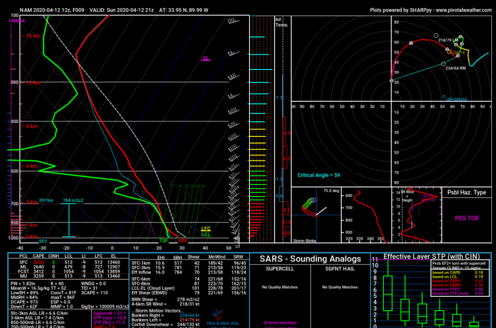
That radar signature is suggestive of at least an EF-3. Yikes.
-
Looks like an intense tornado too given the velocity couplet. Also appears to be a debris signature on CC.
-
Tony Lyza is quite bullish on today.
-
3 minutes ago, PowellVolz said:
Not sure where you are see that. For the most part I’ve read that nothing is off the table. So much uncertainty with this.
.This is spot on. The ceiling is incredibly high today, but we don’t know how things are going to break yet, and likely won’t for a few more hours.
-
 1
1
-
-
-
-
6 minutes ago, DanLarsen34 said:
This speaks to the potential today has. We’re talking about a MAJOR outbreak if things break right.
-
-
Just now, Bob's Burgers said:
Jackson

-
10 minutes ago, jpeters3 said:
Yeah, this seems like it should stay MOD (at least for the next outlook). Only scenario I see for an upgrade to HIGH is if there is the beginning of an outbreak underway.
It’s a tough spot for them to be in too. The ceiling on today is incredibly high.
-
No hint from the SPC that we’ll see an upgrade at any point. Just too much uncertainty at the moment.
-
-
4 minutes ago, jpeters3 said:
FYI, my former PHD advisor's group at CSU runs a 4 km WRF that uses GFS as LBCs. The simulated radar reflectivity loop can be found here:
http://schumacher.atmos.colostate.edu/weather/real_time_wrf/radar_1km_4km/anim.php
UH tracks:
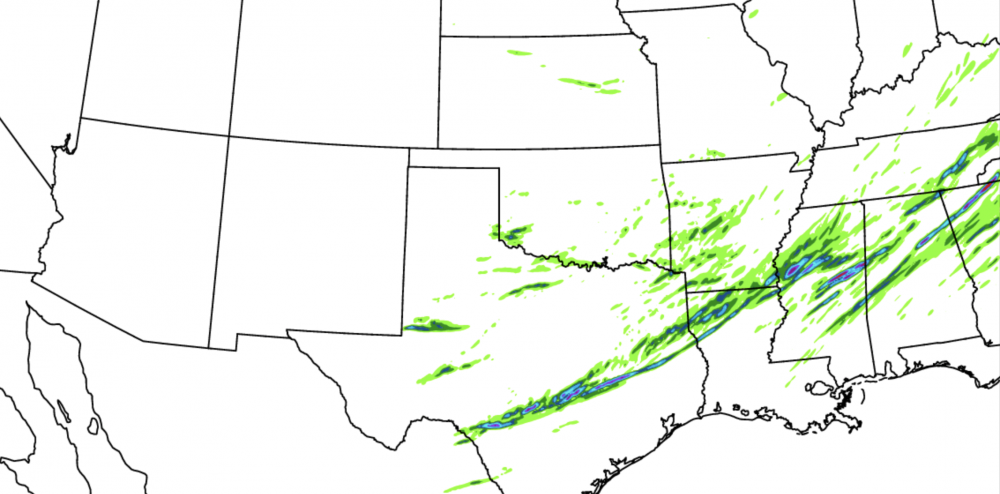
That paints a volatile scenario for tomorrow. Loop towards the middle showed several discrete/semi-discrete cells breaking out across Mississippi.
-
17 minutes ago, jpeters3 said:
This is a tough call, but avoiding large groups in shelters which will almost certainly lead to additional covid infections in favor of a probably comparatively statistically unlikely outcome of a tornado hitting a given location seems like a good tradeoff to me.
I think you’re right. Let’s just hope we don’t have to deal with this affecting people’s lives either way.
-
-
-
Uh oh.. (just one model run, but still).
-
Top two analogs worth noting here.
-
2 minutes ago, jpeters3 said:
FWIW, 18 UTC NAM nest is a similar story. Warm sector is devoid of convection closer to the cold front, and a bunch of junkvection further east....
Interested to see what CAMs do tomorrow.
What if I told you there were insane parameters in place, but no discrete supercells came? Would be something if things actually play out this way.
-
23 minutes ago, MUWX said:
High ceiling event, but there are several reasons that it could bust
The story of the last couple of potential high-end days. lol. We’ll see which “side” wins out.
-
Some good advice here from Tony Lyza.
-
2
-
-
Just now, jpeters3 said:
Please don't post things like this. While some of the projected environmental parameters look impressive, they already don't look as impressive (less CAPE) as events like 4-27-11. And 4-27-11 didn't even quite reach the scope of the super outbreak in 74. I don't think there is any indication that this will exceed the spatial coverage or intensity (number of EF-4+ tornadoes) as either of those outbreaks.
And if there is anything the last few years have taught us, there are plenty of ways for a potent looking event 2 days out to end up busting.On this note: the outflow boundaries laid out by morning convection on 4-27 actually ENHANCED the tornado risk across NE MS, and NW AL. Subtle thing like this won’t be evident until hours before storm initiation is set to occur. Those small details are what can make the difference between a significant outbreak and something “historic.”
4-3 and 4-27 have set the bar EXTREMELY high for any subsequent outbreak to exceed. Even something a magnitude below that (let’s say 60-90 tornadoes, 5-8 violent tornadoes) would be devastating. This certainly has a very high ceiling, but everything has to break right for a 4-27 or 4-3 to occur. We won’t know that until the day one of those events is about to occur again, even if the larger scale suggests it’s possible.
-
That’s the largest day 3 moderate risk I’ve ever seen.


April 12 Severe Event
in Southeastern States
Posted