

George BM
-
Posts
2,903 -
Joined
-
Last visited
Content Type
Profiles
Blogs
Forums
American Weather
Media Demo
Store
Gallery
Posts posted by George BM
-
-
-
Humid. Swampy.
-
 1
1
-
-
Forecast Discussion
Thursday, July 24, 2025 3:28PM EDT
Our break from active and life-threatening weather has once again come to an unfortunate end. From extreme wind storms, high-end derechos, major/violent tornado outbreaks and even an all-time historic blizzard to start out May a few years back, we just cannot seem to catch any break. I mean seriously, what the heck happened at the turn of this decade where since then seemingly EVERY SINGLE KIND of weather event cranks it up to MAXIMUM POWER and causes MAXIMUM pain in this region.
Carrying on…
For the past couple of days, we’ve been enjoying unseasonably cool conditions with highs in the 70-75F range and lows ranging from the M/U 50s in urban areas and 40s in the mountains. This is courtesy of a longwave trough that has settled in over the eastern half of the US. However, it has become overcast this afternoon with high clouds from Dexter which is currently approaching our area from the south. Dexter is a strengthening major hurricane located off of the SC/GA coastline moving northeast. Dexter is beginning to interact with the trough that is centered just west of our region in the Appalachians/ eastern Ohio Valley. This will become cutoff as we go through the evening and, yet again, this will allow a major tropical system (in this case, Dexter) to get captured by the trough rather than kicked and pinwheel it north and then northwestwards into our region.
Rain will spread into the region from southeast to northwest through the night as temps hold in the 60s areawide with the cool air from the trough still in place. This cool air and trough interaction will mean two things.
1. The severe/tornado threat will be low, though not zero, especially in far eastern zones that get a healthy surge of low-level warm tropical air allowing for an elevated tornado threat there.
2. However, the trough interaction will significantly increase the rainfall rates to the northwest and west of the center of Dexter.
As a result, the rain will become very heavy over the region by sunrise tomorrow morning. During the day tomorrow torrential rains with increasingly high winds will batter the greater DC and Baltimore metros with 1.5 to 3 inch per hour rainfall rates becoming commonplace and winds gusting up to hurricane force (75-80+ mph gusts) by the late afternoon/early evening hours.
The wrath of Dexter will reach its climax tomorrow night as the center moves northwest and loops or stalls over/near the Chesapeake Bay and mouth of the Potomac. Winds could gust up to 100+mph across the forecast area as heavy to torrential rains continue leading to basically universal power outages with significant structural damage.
Over the course of the day on Saturday, Dexter will slowly spin down over the region allowing heavy rains and high winds to continue throughout the day. By Sunday, rain should finally taper off to moderate showers with breezy conditions continuing through the day.
Rainfall totals:
For the greater metro areas rainfall totals of 24 to 40 inches will be commonplace with localized amounts of up to 50 inches. Some spots in the mountains could get in excess of 5 feet of rain.
Winds:
Wind gusts will reach tropical storm strength from SE to NW between 5am and midday Friday. They will reach hurricane strength from SE to NW between midday and 7pm Friday.
The strongest winds will occur between 9pm Friday and 6am Saturday with wind gusts in excess of 125mph possible in eastern zones and the Bay. Peak gusts of 90 to 110mph look most likely in the metros for now. Gusts of 75 to 90mph is the most likely scenario in the mountains and along the I-81 corridor. Though higher elevations could potentially gust as high as 110mph.
Once this is all out of here, most likely by Monday, the rest of the coming week looks fairly benign as we head into August with slightly below normal temps and dry conditions for the period… which would be great as, for literally the twentieth time in the past five years, no one will have power. Look, just take care of each other and look out for the elderly and homeless. Be kind. Thoughtful… I'm outta here.
An exhausted forecaster wannabe: George BM
-
4
-
-
9 minutes ago, WxUSAF said:
Both my father and f-I-L have told me the bel air storm is the most intense lightning storm they can remember
I got on radarscope and zoomed in as close as I could into that storm and I still counted nearly 100 lightning strikes on the map with most spots within 500ft of a recent CG.

-
1
-
-
2 hours ago, midatlanticweather said:
I was out mowing and that storm was pretty far away when a bolt hit right next to my neighbor's home. Wild. I stopped mowing. The storms were even further than when I took this screen grab. Blue sunny sky with storm clouds a bit in the distance. Got my attention!! Lol

Has your hearing returned to normal yet?
-
 1
1
-
-
@mappy Congratulations on completing another eventful 584 million mile trip around the sun!

-
 1
1
-
-
6 hours ago, SnowenOutThere said:
I’ve watched the same storm try to fire just north of me in Reston for the past 4 hours and it keeps failing. It seems like we’re just missing some ingredient for now.
One of those pulse ups gave me 0.26" of rain w/ 10-20 mph wind gusts. No lightning.
-
2
-
-
Those earlier storms trained over me earlier dumping 2.31" of rain here! Also got some 40-50mph wind gusts.
Another decent storm by MBY standards.
I'm now up to 7.52" of rain for June.
-
5
-
-
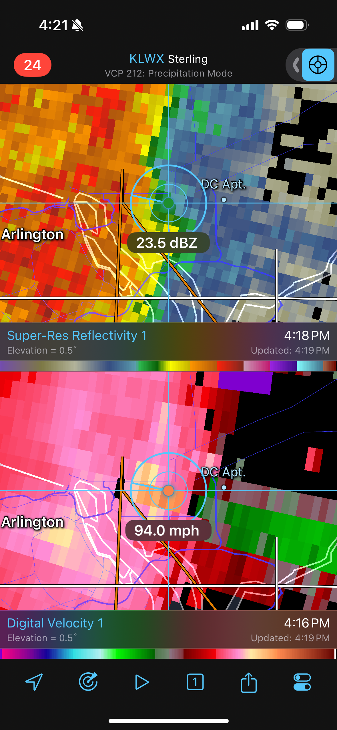
Just now, George BM said:
Wow IAD just gusted up to 60kts(69 mph)!
Now 70 mph! Lol!
-
2
-
-
Wow IAD just gusted up to 60kts(69 mph)!
-
2
-
-
10 minutes ago, CAPE said:
High 96
94 currently. DP 71. Could be worse.
Despite forecast highs of 98-100 over the years, as long as I have lived here taking the under is 100% win.
Yeah. You most likely need a drought and/or a, at least, near 600dm high in July to hit the triple-digits.
I forget. Have you actually hit 100F before? Once? Twice?
-
1
-
-
IAD up to 97F so far.
97/69
-
Just past 10:42pm. The sun has gotten as far north from the equator as it will ever be this year over the western Pacific Ocean!
@CAPE Your worry about your lawn being incinerated will soon be on borrowed time as the solar noon sun angle eventually lowers behind your trees.
Hot summer weather lovers rejoice for your time of celebration has come!
Cold weather lovers you all rejoice as well for the days will get shorter with the sun angle lowering from here on out until the winter solstice, ensuring that the heat and humid will also eventually abate.

-
7
-
 1
1
-
-
5.21" for the month o June so far following 7.62" for May.
12.83" since May 1st.
-
1
-
-
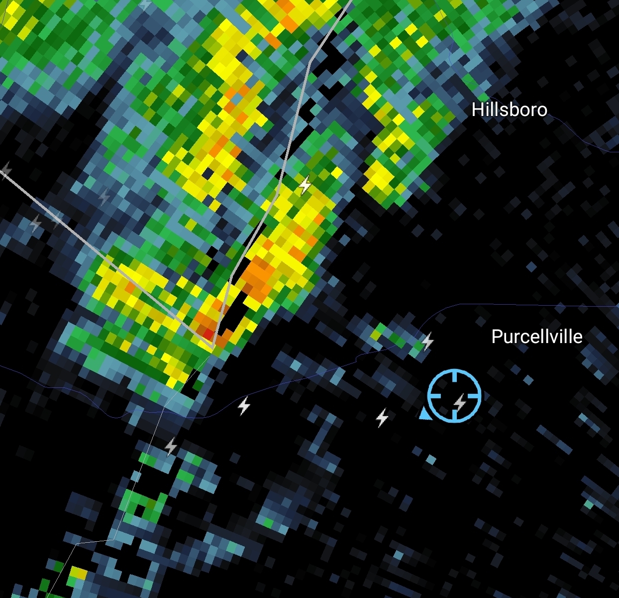
Was in the eastern part of that destructive tagged severe thunderstorm warning earlier (Herndon, VA).
As lots of others also experience, it was briefly fairly intense (by MBY standards) for a couple of minutes with sheets of rain and 40-50 mph wind gusts. The rain and wind arrived simultaneously. I also saw a small jet abort a landing on runway 19L and scale the leading edge of the rain curtain.
Certainly no 80 mph wind gusts here. But it was my best storm in years.
-
1 minute ago, NorthArlington101 said:

RIP

Yes I know it's probably just wonky in that location... hopefully...
-
1
-
-
1 minute ago, yoda said:
Mentions isolated significant gusts to 75mph
I'm guessing 70/30 wind probs based on the watch wording?
-
415
ACUS11 KWNS 191722
SWOMCD
SPC MCD 191722
NJZ000-PAZ000-DEZ000-MDZ000-VAZ000-DCZ000-WVZ000-191915-
MESOSCALE DISCUSSION 1364
NWS STORM PREDICTION CENTER NORMAN OK
1222 PM CDT THU JUN 19 2025
AREAS AFFECTED...MID-ATLANTIC REGION
CONCERNING...SEVERE POTENTIAL...WATCH LIKELY
VALID 191722Z - 191915Z
PROBABILITY OF WATCH ISSUANCE...80 PERCENT
SUMMARY...CONVECTION WILL GRADUALLY INTENSIFY AS THEY MOVE OFF THE
BLUE RIDGE THIS AFTERNOON. DAMAGING WINDS ARE THE PRIMARY HAZARD,
THOUGH ISOLATED LARGE HAIL AND A BRIEF TORNADO OR TWO ARE ALSO
POSSIBLE. A WATCH IS LIKELY.
DISCUSSION...VISIBLE SATELLITE SHOWS CONVECTION GRADUALLY DEEPENING
ALONG THE BLUE RIDGE IN ADVANCE OF AN UPPER-LEVEL TROUGH. GIVEN THE
UPPER 60S TO LOW 70S F DEWPOINTS AND CLEAR SKIES AHEAD OF THIS
ACTIVITY, THE BOUNDARY-LAYER WILL CONTINUE TO DESTABILIZE THROUGH
THE AFTERNOON. 30-35 KTS OF EFFECTIVE SHEAR WILL LIKELY MEAN BROKEN
LINE SEGMENTS AS WELL AS A FEW SUPERCELLS.
THE PRIMARY HAZARD THIS AFTERNOON WILL BE DAMAGING WINDS,
PARTICULARLY WITH ANY LINE SEGMENTS THAT DEVELOP. ISOLATED LARGE
HAIL IS POSSIBLE, BUT WEAK WINDS AT UPPER LEVELS AND POOR MID-LEVEL
LAPSE RATES (SAMPLE BY MORNING SOUNDINGS ACROSS THE REGION) SHOULD
LIMIT THAT THREAT. MODEST ENHANCEMENT TO THE 850 MB WINDS WILL
PROMOTE SUFFICIENT LOW-LEVEL SHEAR FOR THE THREAT OF A BRIEF TORNADO
OR TWO.
..WENDT/HART.. 06/19/2025
..PLEASE SEE WWW.SPC.NOAA.GOV FOR GRAPHIC PRODUCT
ATTN...WFO...PHI...AKQ...CTP...LWX...RNK...PBZ...RLX...
LAT...LON 37618051 38657993 40287794 40817698 40697497 40177473
37627670 36947781 36707996 37018057 37618051
MOST PROBABLE PEAK TORNADO INTENSITY...UP TO 95 MPH
MOST PROBABLE PEAK WIND GUST...55-70 MPH
MOST PROBABLE PEAK HAIL SIZE...UP TO 1.25 IN -
41 minutes ago, yoda said:
Kind of surprised we are almost at 1pm and no MCD. There has been initiation out in WV for a bit
Finally MCD'd.
-
Oh okay...
-
IAD w/ a tropical hourly ob of 84F w/a 78F dewpoint.
-
1
-
-
High Pwats + decent CAPE = torrential lightning w/ those currently warned storms.
-
Severe Thunderstorm Watch out until 7pm from roughly US-15 east.
-
Unusually warm mist here.
75/75 currently at IAD.
Some windows are fogged up.
.png.6a7b3d773740ace2e5962c320ce0a225.png)
July Discobs 2025
in Mid Atlantic
Posted
Cooler temps this morning, but there is a bit of a smoky haze at the surface from last night. Air quality is poor.