

George BM
-
Posts
2,603 -
Joined
-
Last visited
Content Type
Profiles
Blogs
Forums
American Weather
Media Demo
Store
Gallery
Posts posted by George BM
-
-
1 minute ago, katabatic said:
Greetings again from Donner! This epic storm continues. The entire front of the condo building has now disappeared. We’ve been taking turns at an entrance on the windward side, keeping that open (well, kinda) so at least we can get outside. To get this picture, I waded through waist to chest high snow. I have done multiple lake effect chases so I have seen some pretty intense snow but earlier today we had a thunderstorm that easily dropped 4 or 5 inches in 30 minutes. Still no power, no plow and no internet (phone works!) but warm and well fed. What a once in a lifetime experience for someone who loves this stuff.
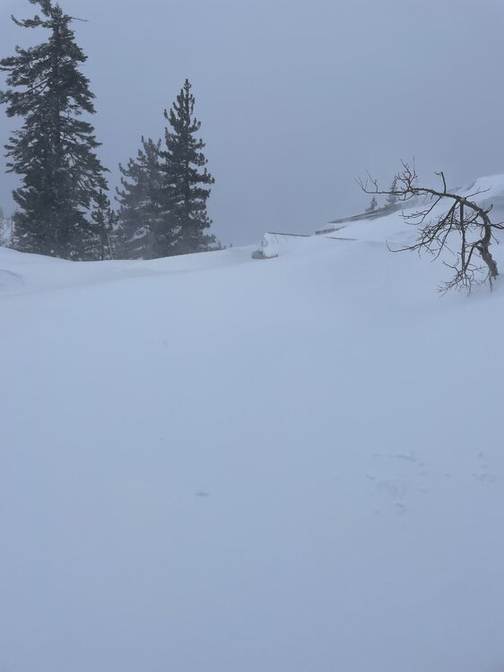
Wild wild west.
-
 2
2
-
-
Happy Meteorological/Climatological Spring.
A seasonal start it appears.
-
1
-
-
Forecast Discussion
Saturday, March 16, 2024 3:28PM EDT
Blizzard Warning in effect from 8AM EDT Sunday, March 17, 2024 until 3PM EDT Monday, March 18, 2024
High Wind Warning in effect from 9AM EDT Sunday, March 17, 2024 until 6PM EDT Monday, March 18, 2024
Hurricane-Force Wind Warning in effect from 2PM EDT Sunday, March 17, 2024 until 6AM EDT Monday, March 18, 2024 (for tidal-Potomac and Chesapeake Bay)
Life-Threatening Late-Winter Storm to cripple the region.
Temps are currently holding in the mid-50sF across the DC metro area but are already starting to fall in far northern Maryland as the cold front associated with the strong northern stream system drops south through the region. Temps will plummet out of the 50s and through the 40s and 30s through the evening and reach the lower 20s in many areas by morning as the unusually cold airmass pushes in. As this occurs through the late afternoon and evening hours skies will become overcast both from lift associated with the southward moving cold front and from the strong southern stream system to our south/southwest. There may be enough lift and moisture associated with the front for some light sprinkles and/or a few flurries/light snow showers to develop through the evening before precip slips to the southeast. Northerly winds will become quite gusty during this time with gusts of 25 to 40 mph.
As the strong southern storm system moves toward the coastal Carolinas tonight it will begin to phase with a second powerful northern stream vort diving south from the eastern Great Lakes/ Toronto region leading to strong diffluence over the surface low leading to rapid deepening. The two will pinwheel around each other as they phase bringing the southern storm and associated surface low northwards as rapid deepening takes place allowing snow to overspread the region by morning from southeast to northwest. The snow will quickly become heavy as NE winds increase with gusts to over 50 mph across the region likely by midday. Temperatures during this time will be in the lower 20sF leading to windchills in the single digits. By the late afternoon/evening the surface low will slow down and eventually stall over the Virginia peninsula/ southern Chesapeake Bay area. The surface pressure could be as low as the mid-950s in millibars breaking monthly low-pressure records in that area. Meanwhile, the areas northwest of the surface low (the greater Washington DC and Baltimore metros) will be getting the worst of this storm with blinding snowfall and widespread 60-75+ mph wind gusts w/ 80-90+ mph gusts along the coast of the Bay. In fact, snowfall rates in the heaviest bands will likely be in the 4-6”+/hr range leading to visibilities as low as 50 feet (effectively zero visibility for the sake of argument) from the late afternoon hours through the night and into Monday morning. Temperatures will remain in the 20s throughout the duration of this event with upper teens possible in the higher elevations north and west and temperatures closer to 32F in far southern MD and along the bay where warmer air will be located near the surface low. Windchills during the duration of the event will stay in the single-digits for most w/ negative single-digits in the mountains and lower teens in southern MD and along the bay.
Near-whiteout and conditions and severe wind gusts will still be ongoing by dawn Monday as the low-pressure system slowly pulls northeastwards. Heavy snow will continue through the late morning to midday hours before tapering off from west to east. When all is set and done with total liquid-equivalent precipitation of 4-7”+ across the region, snowfall totals of 4 to 6 FEET will likely be commonplace with snow drifts of as high as 30 feet possible. Areas in southern MD and near the Bay may end up with slightly less (roughly 2 to 4 feet) as the warmer air associated with the low-pressure center cuts down on totals in that area.
This will be the worst blizzard, by far, to impact the region since weather records started in the later 1800s. It will essentially be a high-impact hurricane with snow instead of rain as the main precip-type. People who venture outside during this time may get disoriented and lost in the whiteout conditions and/or get seriously injured by flying debris. Emergency services may not be able to reach you for days should something happen to you outside. This is the DC and Baltimore urban corridor not Lake Tahoe or the Japanese Alps. We’re not equipped with the snow removal equipment that they have. So, if you absolutely must venture outside during the storm no caution that you use would be too extreme given the circumstances.
Temperatures will only rebound to the lower 30s as skies start clearing by mid to late afternoon on Monday.
Forecaster Wannabe: George BM
-
6
-
 1
1
-
-
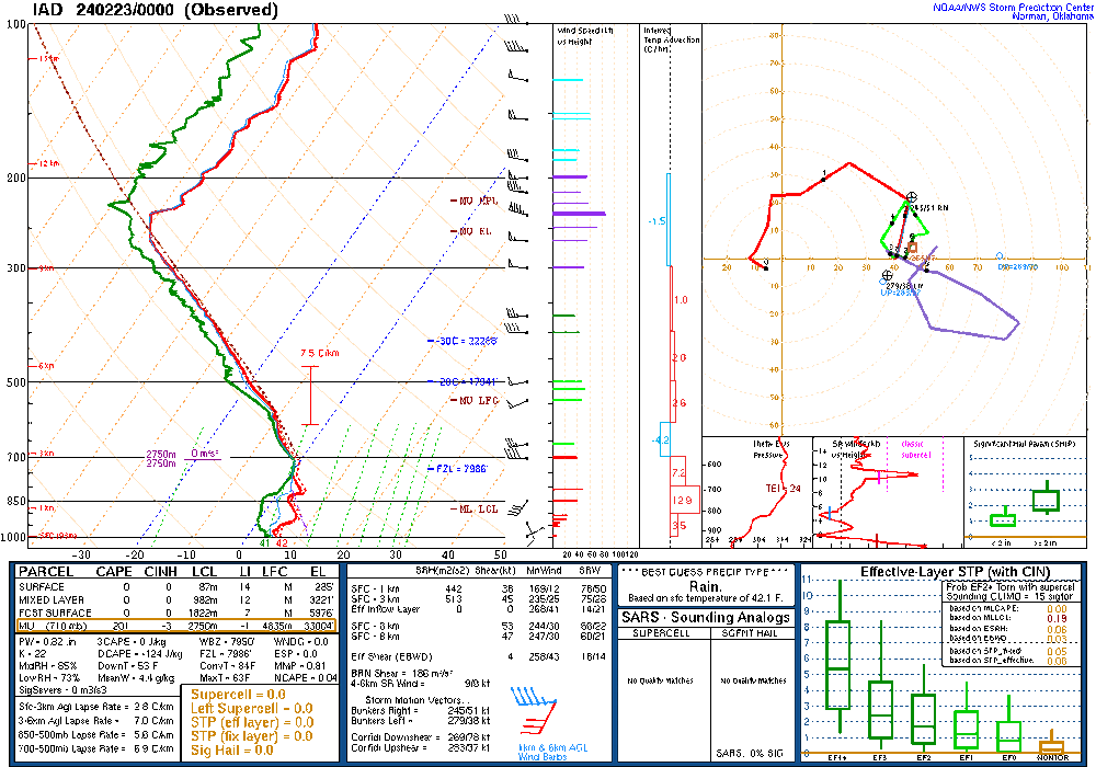
IAD with a gust to 51kts (59mph).
-
1
-
-
3 hours ago, snownut said:
What time are the storms rolling through IAD? Probably a bumpy flight.. I am scheduled to land at 5:45
Yeap that's right around the time that the front should be moving through IAD give or take 15-30mins.
What kind of plane are you flying in, btw? Boeing 757? 767?
-
13 minutes ago, vastateofmind said:
Excerpt from this morning's LWX disco and SPC's Day 1 outlook...incoming radar is pretty lit.
The heaviest precipitation looks arrive later this afternoon and
into this evening (3-8pm) before things quickly ending from west to
east before midnight. Thunderstorm probabilities are low, but are
not zero, for this front, given the increasing dewpoints and strong
forcing. A marginal risk for severe weather has been issued from
north-central MD and northern VA west into the MD/WV mountains.
Forecast instability values are generally less than 500 J/kg with 0-
6 km shear values over 50-60 kts. With that said, a narrow line of
shallow convection may develop along and ahead of the front later
this afternoon and evening. Lightning will be limited with wind as
the main concern as this linear convective line pushes through.
Gusts of 45-55 mph can be expected with this convective line of
showers as it pushes from west to east across the region.
Rainfall amounts 0.5 to 1 inch can be expected areawide outside
of the Alleghenies where 1 to 2 inches of rain is expected.
Flood Watches remain in effect for western Grant, western
Mineral, and Garrett counties to encompass this heavier rain
threat combined with already saturated soils and elevated from
melted snowpack in this area.
That MRGL has since been expanded east across the region for the 13z update.
-
2
-
-
IAD at 69F tying its record high for the day from 2002.
-
12/06/2023: T (brief light graupel (~2:25pm))
12/11/2023: 0.9" ( Fairly heavy wet snow overnight... heaviest between 2:45 and 3:35am)
1/01/2024: T (Flurries w/ some graupel from late morning into the afternoon before changing to very light rain/drizzle)
1/06/2024: T (Morning sleet w/ few flakes before changing into a cold soaking afternoon rain)
1/14/2024: T (Moderate snow squall around 11am. Some ground whitening at the bottom of fences)
1/15-16/2024: 4.5" (Light snow started in the 2am hour (15th) continued mostly uninterrupted as flurries/light snow rimmed flakes through the day. Picked up to moderate at times between 7-11pm. Some light snow/freezing drizzle continued into the wee hours of the 16th. Freezing drizzle continues as of this morning.)
1/19/2024: 4.1" (Snow started in the 2am hour<-- (sound familiar?) and was moderate to maybe even modestly heavy at times (heaviest rates in the 5am hour (~1"/hr)). Flurries to light snow between 6am and 9am followed by light to occasionally moderate snow between 9am and 11am. Snow slowly tapered down to flurries through the early/mid afternoon before briefly mostly ceasing in the 3pm hour. Moderate snow squalls moved through during the 4pm hour.)
2/13/2024: 0.6" (Following a roughly 5-7am lull in the rain, precip changed over to snow between 7:10am and 7:20am w/ moderate to moderate/heavy snow until it was nearing 9am followed by light snow until around 9:30am. Temp bottomed out at 34F.)
2/17/2024: 1.5" (Snow started in the 12am hour (could've been a few raindrops mixed in). The snow became fairly heavy during the 1am hour (1-1.5"/hr rates), continued light/moderate during the 2am hour and mostly tapered off by 3am.
2/24/2024: T (Flurries between 5pm and 6:15pm. Briefly up to flurries/very light snow intensity around 6pm w/ slightly bigger flakes.)
2023-2024 winter total as of Feb 25, 2024: 11.6"
-
1
-
-
Down to 21F at IAD.
-
Flurries.
IAD at 39/27.
-
There some very skinny elevated CAPE depicted on the 0z IAD sounding w/ an EL all the way up around 33,000ft. A very small slither of CINH around 575mb.
-
 1
1
-
-
Another relatively strange (for this area anyway) elevated storm event was what occurred on the evening of April 3, 2011. Radar returns were not too impressive as activity moved through from NW to SE from mid evening into the first few hours of April 4th. But there was photogenic lightning for several hours, especially across northern MD from Frederick, MD and between Baltimore and DC.
-
1
-
-
1 minute ago, high risk said:
Very bizarre. The model soundings certainly don't suggest thunder, unless you lift a parcel from up around 700 mb, and that's rarely a path to thunder here.
The 0z IAD sounding will be interesting to see.
-
2
-
-
A 242kA positive bolt north of Aldie. Strong.
-
31 minutes ago, 87storms said:
I had a pretty diesel microburst roll through my spot in Bethesda a week prior to that, too.
Remember that. Estimated gusts up to 100 mph in Bladensburg, MD IIRC.
-
1
-
-
Unsolicited local severe outbreak rankings IMO since 2000:
MCSs:
1. June 29, 2012
2. June 4, 2008
3. August 26, 2003
Tornadoes:
1. September 17, 2004
2. September 24, 2001
3. April 28, 2002
-
12/06/2023: T (brief light graupel (~2:25pm))
12/11/2023: 0.9" ( Fairly heavy wet snow overnight... heaviest between 2:45 and 3:35am)
1/01/2024: T (Flurries w/ some graupel from late morning into the afternoon before changing to very light rain/drizzle)
1/06/2024: T (Morning sleet w/ few flakes before changing into a cold soaking afternoon rain)
1/14/2024: T (Moderate snow squall around 11am. Some ground whitening at the bottom of fences)
1/15-16/2024: 4.5" (Light snow started in the 2am hour (15th) continued mostly uninterrupted as flurries/light snow rimmed flakes through the day. Picked up to moderate at times between 7-11pm. Some light snow/freezing drizzle continued into the wee hours of the 16th. Freezing drizzle continues as of this morning.)
1/19/2024: 4.1" (Snow started in the 2am hour<-- (sound familiar?) and was moderate to maybe even modestly heavy at times (heaviest rates in the 5am hour (~1"/hr)). Flurries to light snow between 6am and 9am followed by light to occasionally moderate snow between 9am and 11am. Snow slowly tapered down to flurries through the early/mid afternoon before briefly mostly ceasing in the 3pm hour. Moderate snow squalls moved through during the 4pm hour.)
2/13/2024: 0.6" (Following a roughly 5-7am lull in the rain, precip changed over to snow between 7:10am and 7:20am w/ moderate to moderate/heavy snow until it was nearing 9am followed by light snow until around 9:30am. Temp bottomed out at 34F.)
2/17/2024: 1.5" (Snow started in the 12am hour (could've been a few raindrops mixed in). The snow became fairly heavy during the 1am hour (1-1.5"/hr rates), continued light/moderate during the 2am hour and mostly tapered off by 3am.
2023-2024 winter total as of Feb 17, 2024: 11.6"
-
1
-
-
5 minutes ago, Scarlet Pimpernel said:
Semi off-topic, but is TT still down? It's been out apparently most of the afternoon.
Yeap.
-
2
-
-
2 minutes ago, Interstate said:
is TT down for anyone else or is it just me?
Yeah server appears to be down this afternoon.
-
12/06/2023: T (brief light graupel (~2:25pm))
12/11/2023: 0.9" ( Fairly heavy wet snow overnight... heaviest between 2:45 and 3:35am)
1/01/2024: T (Flurries w/ some graupel from late morning into the afternoon before changing to very light rain/drizzle)
1/06/2024: T (Morning sleet w/ few flakes before changing into a cold soaking afternoon rain)
1/14/2024: T (Moderate snow squall around 11am. Some ground whitening at the bottom of fences)
1/15-16/2024: 4.5" (Light snow started in the 2am hour (15th) continued mostly uninterrupted as flurries/light snow rimmed flakes through the day. Picked up to moderate at times between 7-11pm. Some light snow/freezing drizzle continued into the wee hours of the 16th. Freezing drizzle continues as of this morning.)
1/19/2024: 4.1" (Snow started in the 2am hour<-- (sound familiar?) and was moderate to maybe even modestly heavy at times (heaviest rates in the 5am hour (~1"/hr)). Flurries to light snow between 6am and 9am followed by light to occasionally moderate snow between 9am and 11am. Snow slowly tapered down to flurries through the early/mid afternoon before briefly mostly ceasing in the 3pm hour. Moderate snow squalls moved through during the 4pm hour.)
2/13/2024: 0.6" (Following a roughly 5-7am lull in the rain, precip changed over to snow between 7:10am and 7:20am w/ moderate to moderate/heavy snow until it was nearing 9am followed by light snow until around 9:30am. Temp bottomed out at 34F.)
2023-2024 winter total as of Feb 13, 2024: 10.1"
-
Looked outside and it almost looks like a coating of snow fell overnight.
Heavy frost here. 28F at IAD.
-
2
-
-
Average start. May be get buried under feet of snow by month's end.
-
Forecast Discussion
Friday, February 16, 2024 3:28PM EST
Winter Storm Warning in effect for the Greater Washington DC metro region from 5PM EST Friday afternoon until 6AM EST Saturday morning.
Blizzard Warning in effect for the Greater Washington DC metro region from 6AM EST Saturday morning until 9AM EST Sunday morning.
Wind Chill Advisory in effect for the Greater Washington DC metro region from 2AM EST Sunday morning until 9AM EST Sunday morning.
High to Extreme Impact Winter Weather Event will commence across the region this evening.
Clouds have overspread the forecast area with the first reports of light snow/snow flakes coming in around Charlottesville. Temps currently hover around 28-32F across the region w/ dewpts in the low 10s. The snow will spread northeastwards over the area over the next several hours probably reaching the District of Columbia between 22-23z (5-6pm) and Baltimore as well as the MD/PA line by 1z (8pm) or so. Temps will fall into the mid/upper 20s areawide as the atmosphere wetbulbs. Snow will become heavier and northeasterly surface winds will increase throughout the night as the strong southern shortwave and associated surface low move east out of the NC mountains and towards the coast by dawn. Temperatures will remain fairly steady in the mid to upper 20sF throughout the night. However, with NE winds gusting up to 35 mph as dawn approaches, wind chills will drop into the lower teens.
As the surface low approaches the VA/NC coast a powerful northern stream shortwave dropping in from the northwest will phase with the southern system leading to 1.) The surface low slowing down and veering NNE over the mouth of the Chesapeake Bay and 2.) Explosive deepening of said surface low. As this occurs snowfall rates will become very heavy (potentially exceeding 3”/hr) owing to strong lift and upper-level divergence. Winds, which will have northerly component by then, will become strong to perhaps damaging at times, gusting 50 to 60 mph (perhaps to around 70 mph at times over the Bay) particularly by the late afternoon and evening hours. This will lead to near-whiteout conditions over the region throughout the day and into Saturday night. With the strong dynamics in place occasional lightning/thunder is possible. Temps will slowly fall from the mid/upper 20s during the morning into the lower 20s by late in the afternoon dropping windchills well into the single digits.
The surface low will most likely bottom out in the upper 960smb range around 03z-06z Sunday as it stalls or possibly does a small loop around Ocean City, Maryland before moving slowly off to the east as a strong, large north Atlantic low coupled with a strong Greenland high (strongly -NAO pattern) keeps the storm from quickly heading NE. Near-whiteout blizzard conditions will continue through the night and into Sunday morning until snow starts tapering off from west to east later Sunday morning. Temps during this time will fall from the lower 20s/near 20F into the mid-teens as colder air wraps in behind the low-pressure center. With winds remaining very strong through the night. Windchills values will drop to around 5F or so below zero across the Greater DC/Baltimore metropolitan regions. Wind Chill Advisories will likely be needed across the majority of the forecast area Sunday morning.
By the end of it all snowfall totals will generally be in the 32”-48” range across the region w/ localized areas that end up under the heaviest banding the longest getting 4+ feet. Snow totals will be most likely end up around 20”-30”+ in eastern MD near the eastern shore of the Chesapeake Bay. The higher elevations far north and west may end up with 36 to 52 inches w/ localized amounts of 5+ feet possible. Snow drifts may end up as high as 20 feet in some spots. This will make travel impossible for most for a period of time after the snow has ended, especially with temperatures remain below freezing for the entire upcoming workweek.
Forecaster Wannabe: George BM
-
5
-
 1
1
-
-


March Discobs 2024
in Mid Atlantic
Posted
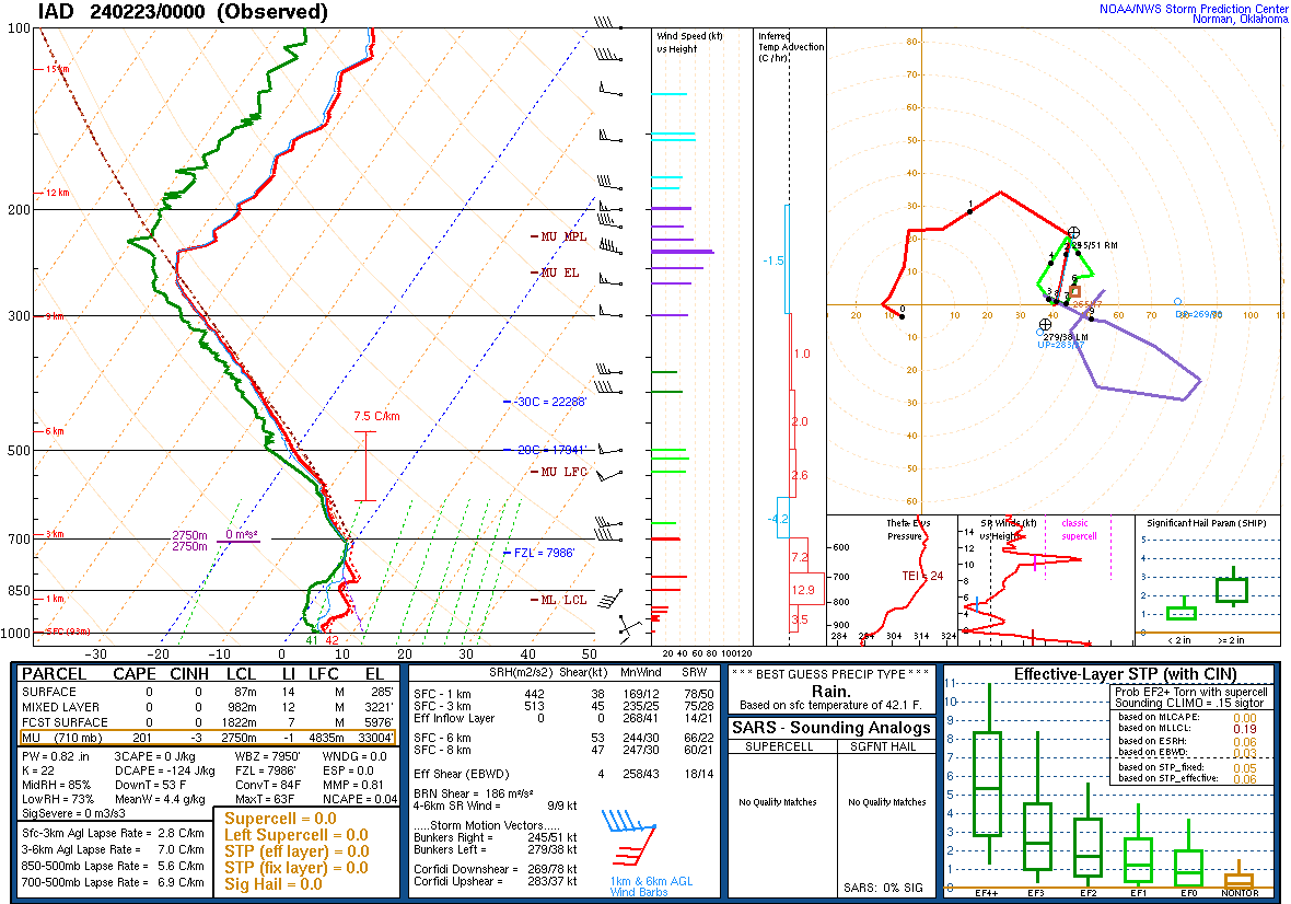
IAD w/ a gust to 47kts just now.