klw
-
Posts
5,007 -
Joined
-
Last visited
Content Type
Profiles
Blogs
Forums
American Weather
Media Demo
Store
Gallery
Everything posted by klw
-
Up to 5 inches now.
-
This is generally where I am, 1240 feet in elevation 43.75°N 72.36°W
-
3 inches as of 3pm
-
Snow started lightly here about 11 and in earnest at about 11:15 right after I got back from running my errands, including shear pins and sparkplug for the snow blower. Already whitening everything up.
-
Well I better go run my errands now and beat the fun. Most SWFEs are good for 4.5 to 7 inches here so in my head I am planning on that.
-
Upgraded to a Warning for tomorrow for home. https://forecast.weather.gov/showsigwx.php?warnzone=VTZ012&warncounty=VTC027&firewxzone=VTZ012&local_place1=West Norwich VT&product1=Winter+Storm+Warning&lat=43.7543&lon=-72.3728#.Ybz8-GjMJPY Caledonia-Washington-Orange-Windsor-Eastern Addison- Eastern Rutland- Including the cities of St. Johnsbury, Montpelier, Bradford, Randolph, Springfield, White River Junction, Bristol, Ripton, East Wallingford, and Killington 330 PM EST Fri Dec 17 2021 ...WINTER STORM WARNING IN EFFECT FROM 1 PM SATURDAY TO 7 AM EST SUNDAY... * WHAT...Heavy snow expected. Total snow accumulations of 5 to 8 inches. * WHERE...Portions of central, northeast and southern Vermont. * WHEN...From 1 PM Saturday to 7 AM EST Sunday. * IMPACTS...Travel could be very difficult. * ADDITIONAL DETAILS...Snow will develop across the region from south to north beginning mid-day Saturday and may become briefly heavy at times into the early overnight hours before ending around sunrise Sunday. Some localized pockets of light freezing drizzle are possible early Sunday morning, which could make surfaces slick.
-
I got a Winter Storm Watch issued overnight: .WINTER STORM WATCH IN EFFECT FROM SATURDAY AFTERNOON THROUGH LATE SATURDAY NIGHT... * WHAT...Snow. Total snow accumulations of 6 to 8 inches possible. * WHERE...Portions of northeast, central and southern Vermont. * WHEN...From Saturday afternoon through late Saturday night. * IMPACTS...Travel could be very difficult. * ADDITIONAL DETAILS...Snow will develop across the region from south to north beginning mid-day Saturday and may become briefly heavy at times into the early overnight hours before ending around sunrise Sunday. BTV nudged the numbers up on their map
-
Route 2 to Route 2 jack.
-
BTV Maps: Map for dreamers
-
With any storm, when in doubt, always predict Woodford VT gets the most snow.
-
Probably "Grey Poop On" brand.
-
Lets review where things look for the weekend: 1. 5- 8 inches for my area 2. Falls on weekend 3. Starts late enough I can take trash and recycling to the dump on Saturday AM 4. Ends soon enough, I can dig out the driveway on Sunday. I approve of this approach.
-

December 2021 Obs/Disco...Dreaming of a White-Weenie Xmas
klw replied to 40/70 Benchmark's topic in New England
Hey I have a WWA for tonight: https://www.weather.gov/btv/headlines .WINTER WEATHER ADVISORY NOW IN EFFECT FROM 5 PM THIS AFTERNOON TO 7 AM EST THURSDAY... * WHAT...Mixed precipitation expected. Total snow accumulations of up to two inches and ice accumulations of a light glaze. * WHERE...Most areas along and east of the Green Mountains in Vermont. * WHEN...From 5 PM this afternoon to 7 AM EST Thursday. * IMPACTS...Plan on slippery road conditions tonight, including the evening commute. * ADDITIONAL DETAILS...Snow will begin by late this afternoon and gradually mix with sleet and freezing rain before changing over to all rain during the early morning hours on Thursday. Road temperatures will be cold enough to enhance the potential for freezing rain and difficult travel conditions. Big big winter in progress! NWS map: -
December 2021 Obs/Disco...Dreaming of a White-Weenie Xmas
klw replied to 40/70 Benchmark's topic in New England
-
December 2021 Obs/Disco...Dreaming of a White-Weenie Xmas
klw replied to 40/70 Benchmark's topic in New England
In 2017, I got 10.8 inches of snow on Christmas. I don't remember if others got much. -
December 2021 Obs/Disco...Dreaming of a White-Weenie Xmas
klw replied to 40/70 Benchmark's topic in New England
When you start trying to steal our snow! -
.9 overnight brings me to 3.6 total for the "event" and into double digits on the season.
-
3.6 total after another .9 overnight.
-
2.7 inches new today
-
December 2021 Obs/Disco...Dreaming of a White-Weenie Xmas
klw replied to 40/70 Benchmark's topic in New England
snow for the Patriots tonight? -
December 2021 Obs/Disco...Dreaming of a White-Weenie Xmas
klw replied to 40/70 Benchmark's topic in New England
Some nice steady light snow here. Edit: I double checked and it has stopped so steady may have been the wrong word. It was pretty under the garden light as I rowed in the garage. -
December 2021 Obs/Disco...Dreaming of a White-Weenie Xmas
klw replied to 40/70 Benchmark's topic in New England
steady light snow here, closing in on an inch. -
Our long national nightmare is over. I can report that the Church Street trees are now 99% leaf free.
-
steady light snow here in the 05055
-
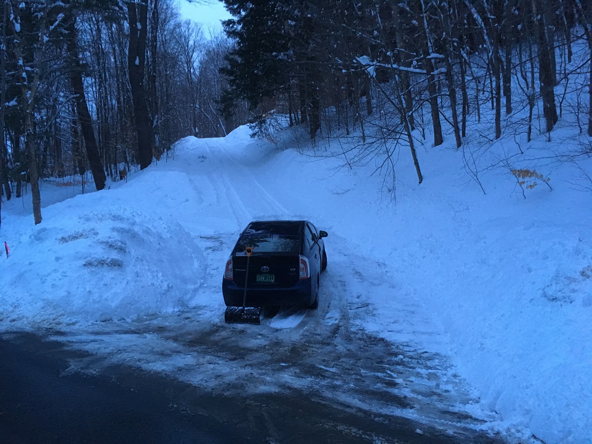
Well it looks like they delivered it a little while ago. UPS is usually good with us so yesterday was a surprise especially as we had gotten a notice yesterday AM that it was out for delivery. They used to always drive up to the house so when COVID lockdown happened we put a tub outside our garage to go contactless. We also put one down by the mailbox for USPS to use because they have never driven to the house even with certified. They would just give us a slip telling us to go to the town post office and then drive around with the package in the car so we couldn't even pick it up that day and sometimes not the next. USPS has been great about the tub but UPS started using the roadside one even when the package wouldn't fit. We would find packages sticking out of the container or in the ditch behind. We had to hide the roadside container in a parking area- USPS uses it still so that has been a win. I don't blame them for not wanting to come up the driveway but it is in much better state than when we bought it. Here is a shot from 2018: