

klw
-
Posts
4,487 -
Joined
-
Last visited
Content Type
Profiles
Blogs
Forums
American Weather
Media Demo
Store
Gallery
Posts posted by klw
-
-
Storms just reached Rutland but the camera faces east
-
Severe Weather Statement National Weather Service Burlington VT 639 PM EDT Thu Jul 13 2023 NYC031-VTC001-021-132245- /O.CON.KBTV.TO.W.0001.000000T0000Z-230713T2245Z/ Essex NY-Addison VT-Rutland VT- 639 PM EDT Thu Jul 13 2023 ...A TORNADO WARNING REMAINS IN EFFECT UNTIL 645 PM EDT FOR SOUTHEASTERN ESSEX...SOUTHWESTERN ADDISON AND NORTHWESTERN RUTLAND COUNTIES... At 639 PM EDT, a severe thunderstorm capable of producing a tornado was located over Lake Dunmore, moving northeast at 30 mph. HAZARD...Tornado and two inch hail. SOURCE...Radar indicated rotation. IMPACT...Flying debris will be dangerous to those caught without shelter. Mobile homes will be damaged or destroyed. Damage to roofs, windows, and vehicles will occur. Tree damage is likely. This tornadic thunderstorm will remain over mainly rural areas of southeastern Essex, southwestern Addison and northwestern Rutland Counties, including the following locations... Benson Bay, Catfish Bay In Addison County, Huntley Island, Forest Dale, Beadles Cove, Larrabees Point, Beartrap Island, Kerby Point, Hollands Pasture Island, and East Shoreham. -
2 minutes ago, Ginx snewx said:
63 yr old man died in Barre in his home from the flood
https://vtdigger.org/2023/07/13/vermont-reports-first-flood-related-fatality/
-
It looks like the cell moving into Addison County is being picked up by this camera in Middlebury:
-
 1
1
-
-
Other views here:
https://www.wcax.com/weather/cams/
current cell may go straight over the airport soon (edit- looks like it will miss to the west (behind the camera)
-
2
-
-
Can watch storm come into Burlington off the lake here:
-
1
-
 2
2
-
-
BTV discussion (will Wiz make his wife read it to him- not for lack of ability to comprehend):
NEAR TERM /THROUGH FRIDAY NIGHT/...
As of 332 PM EDT Thursday...Active severe weather is ongoing
through this evening as an unseasonably strong low pressure
system drags a cold front eastward through our region tonight.
As expected, ingredients are present for rotating thunderstorms
in this region, near the triple point of a dynamic low pressure
system passing northeastward through the St. Lawrence Valley.
Our thermodynamic environment is impressive with mixed layer
CAPE at 2 PM of 1500-2000 J/kg, steep low level lapse rates and
moderate mid-level lapse rates helping updrafts strengthen.
Southwesterly wind shear is ample to keep storm structures
organized, with effective shear of 30 to 35 knots, and rotation
is substantial with 0-1 km helicity of 100 to 150 m2/s2.
Additionally, strong synoptic southerly winds will gradually
expand eastward, which are being channeled up the Champlain
Valley with wind gusts locally near 35 MPH. An occasional
stronger gust may cause isolated damage outside of the
thunderstorms, especially where we`ve seen very wet conditions.

A mixture of storm modes are present, which include linear
segments and discrete cells, which could include supercells. The
main hazards are damaging winds and flash flooding. Wind damage
has already been reported in the northern New York this
afternoon. Rotating storms have resulted in a reported funnel
cloud, but relatively high cloud bases (3000 feet or higher) may
limit the tornado potential. As thunderstorms expand northward
and eastward off of the Adirondacks, we will be concerned with
rotating storms and enhanced gusts in the Champlain Valley due
to enhanced low level convergence.

As the evening progresses, any discrete storms should tend to
be absorbed into a single fast moving squall line. Brief spinups
are possible along this line, and its fast forward speed will
tend to keep its severity going all the way eastward through
Vermont even as daytime heating. Scattered wind damage is
expected with the squall line. Less wind will be needed to
produce downed trees than typical given saturated soils in most
areas currently in a flood watch. Where a combination of
discrete and linear storms move over the same area, flash
flooding due to multiple rounds of heavy rain remains possible.
A heightened concern for flooding remains in our hard hit areas
of central Vermont, where capacity for additional heavy rain is
low. Improving conditions will arrive overnight with winds
becoming light and drier air settling in behind the cold front.
-
3
-
 1
1
-
-
-
https://forecast.weather.gov/product.php?site=BTV&issuedby=BTV&product=AFD&format=CI&version=1&glossary=1

Otherwise, damaging winds are the main threat, with large hail
mainly confined to any rotating storms during the period.
Damaging winds may be more likely to uproot trees in today`s
event given saturated ground conditions areawide. Severe threat
gradually wanes across central/ern VT late this evening as
storms encounter weakening CAPE with onset of diurnal cooling
cycle.

We`ll need to watch the southern end of the potential convective
line, where some of the CAMs output and HREF suggest best
potential for training storms toward the end of the event this
evening. Thinking most rainfall is in 0.75-1" range, but
locally 1-1.5" and maybe localized 2" totals for Rutland/Windsor
counties if storms take on more of an NE-SW orientation
parallel to weakening deep-layer shear in the 00-03Z period this
evening. Low Flash flood guidance values - a function of
saturated antecedent soil conditions - of roughly 1.2-1.5" in 3
hours will potentially be exceeded with the type of intense
rainfall that these thunderstorms can produce. As such, Flood
Watch continues to look good, and will highlight greatest
potential of flash flooding is in s-central VT.
-
https://forecast.weather.gov/product.php?site=BTV&issuedby=BTV&product=AFD&format=CI&version=1&glossary=1

Convective allowing models are consistent in their depiction of
convective initiation in vcnty of St. Lawrence County 18-19Z,
with convective storms moving steadily eastward through the late
afternoon hrs in nrn NY and across VT during the late afternoon
thru evening hours. Best vertical shear is in the sfc-700mb
layer, with excellent hodograph curvature and sfc-1km SRH values
exceeding 100 m2/s2, especially across nrn NY. Weakening mid-
level flow and shear suggests updrafts may rain back on
themselves later in the convective evolution, with potential for
storm mergers and upscale growth into a QLCS. Until that time
however, environment does support supercell development with
30-40kts of sfc-6km bulk shear and aforementioned strong low-
level SRH and high CAPE values. Can`t rule out an isolated
tornado or two, especially nrn NY ewd into the Champlain Valley,
where stronger southerly PBL flow will exist with terrain
driven channeling effects. Vermont averages one tornado per
year, and this is the type of convective environment that can
be conducive for isolated tornadoes to happen in our region.
-
The washout in this video is impressive:
https://www.wcax.com/2023/07/12/dozens-vermont-roads-remain-closed/
-
My favorite part of the Governor's midday press conference was the guy who said they are still looking for the bridge that got washed out in Vershire. He then added that they are not going to put it back when they find it but they would like to find it anyway. (he was smiling as he added the second part)
-
3
-
-
40 minutes ago, STILL N OF PIKE said:
When does flood threat resume
Flood watch up here runs from 2pm tomorrow to 2am Friday.
-
1
-
-
Flood watch issued for most of Vermont for tomorrow into Friday:
https://forecast.weather.gov/wwamap/wwatxtget.php?cwa=BTV&wwa=flood watch
Flood Watch National Weather Service Burlington VT 1259 PM EDT Wed Jul 12 2023 NYZ028-031-034-035-VTZ003-004-006>011-016>021-130845- /O.NEW.KBTV.FA.A.0003.230713T1800Z-230714T0600Z/ /00000.0.ER.000000T0000Z.000000T0000Z.000000T0000Z.OO/ Eastern Clinton-Western Clinton-Western Essex-Eastern Essex- Orleans-Essex-Lamoille-Caledonia-Washington-Western Addison- Orange-Western Rutland-Eastern Franklin-Eastern Chittenden- Eastern Addison-Eastern Rutland-Western Windsor-Eastern Windsor- Including the cities of Champlain, Plattsburgh, Dannemora, Ellenburg, Lake Placid, Newcomb, Port Henry, Ticonderoga, Derby, Newport, Island Pond, Lunenburg, Johnson, Stowe, Hardwick, St. Johnsbury, Montpelier, Waitsfield, Middlebury, Vergennes, Bradford, Randolph, Fair Haven, Rutland, Enosburg Falls, Richford, Richmond, Underhill, Bristol, Ripton, East Wallingford, Killington, Bethel, Ludlow, Springfield, and White River Junction 1259 PM EDT Wed Jul 12 2023 ...FLOOD WATCH IN EFFECT FROM THURSDAY AFTERNOON THROUGH LATE THURSDAY NIGHT... * WHAT...Flash flooding caused by excessive rainfall is possible. * WHERE...In Vermont... Most of central and northern Vermont except Grand Isle, Western Chittenden, and Western Franklin Counties. In New York... Essex and Clinton Counties. * WHEN...From Thursday afternoon through late Thursday night. * IMPACTS...Excessive runoff may result in flash flooding, especially along river and streams and in low-lying and flood-prone locations. * ADDITIONAL DETAILS... - Additional rainfall is expected Thursday afternoon as a line of strong thunderstorms moves through. Rivers and streams are already running high and any additional rainfall will go straight to run-off in areas that have recently flooded. Additional forecast rainfall amounts for Thursday afternoon are 1 to 1.5 inches, locally up to 2 inches in the heaviest storms.-
1
-
-
Flood watch issued for most of Vermont for tomorrow into Friday:
https://forecast.weather.gov/wwamap/wwatxtget.php?cwa=BTV&wwa=flood watch
Flood Watch National Weather Service Burlington VT 1259 PM EDT Wed Jul 12 2023 NYZ028-031-034-035-VTZ003-004-006>011-016>021-130845- /O.NEW.KBTV.FA.A.0003.230713T1800Z-230714T0600Z/ /00000.0.ER.000000T0000Z.000000T0000Z.000000T0000Z.OO/ Eastern Clinton-Western Clinton-Western Essex-Eastern Essex- Orleans-Essex-Lamoille-Caledonia-Washington-Western Addison- Orange-Western Rutland-Eastern Franklin-Eastern Chittenden- Eastern Addison-Eastern Rutland-Western Windsor-Eastern Windsor- Including the cities of Champlain, Plattsburgh, Dannemora, Ellenburg, Lake Placid, Newcomb, Port Henry, Ticonderoga, Derby, Newport, Island Pond, Lunenburg, Johnson, Stowe, Hardwick, St. Johnsbury, Montpelier, Waitsfield, Middlebury, Vergennes, Bradford, Randolph, Fair Haven, Rutland, Enosburg Falls, Richford, Richmond, Underhill, Bristol, Ripton, East Wallingford, Killington, Bethel, Ludlow, Springfield, and White River Junction 1259 PM EDT Wed Jul 12 2023 ...FLOOD WATCH IN EFFECT FROM THURSDAY AFTERNOON THROUGH LATE THURSDAY NIGHT... * WHAT...Flash flooding caused by excessive rainfall is possible. * WHERE...In Vermont... Most of central and northern Vermont except Grand Isle, Western Chittenden, and Western Franklin Counties. In New York... Essex and Clinton Counties. * WHEN...From Thursday afternoon through late Thursday night. * IMPACTS...Excessive runoff may result in flash flooding, especially along river and streams and in low-lying and flood-prone locations. * ADDITIONAL DETAILS... - Additional rainfall is expected Thursday afternoon as a line of strong thunderstorms moves through. Rivers and streams are already running high and any additional rainfall will go straight to run-off in areas that have recently flooded. Additional forecast rainfall amounts for Thursday afternoon are 1 to 1.5 inches, locally up to 2 inches in the heaviest storms. -
The 12Z model runs are concerning for the next 5 days.
-
3
-
-
16 minutes ago, CoastalWx said:
Wtf does this even mean?
Tight end likely open on an out route.
-
2
-
-
46 minutes ago, ineedsnow said:
death valley going 130 now
Saturday NightMostly clear, with a low around 100.SundaySunny and hot, with a high near 130.Have they installed?
-
1
-
4
-
-
1 hour ago, tunafish said:
Just awful. Stating the obvious here but the recovery efforts are going to be $$$ and last for months.
Vermont's topography and the fact that most towns are settled along the rivers in the valley make it a "perfect" candidate for significant flooding. The water just has nowhere to go.
And it's not like these are people building new multi-million dollar homes along the floodplains of prime hurricane country. These are hundreds of years old settlements. That is to say, you can't fault anyone for the losses they're experiencing.
Vermont also has a massive housing shortage which will make it even harder on the displaced.
-
1
-
 1
1
-
-
1 hour ago, powderfreak said:
Wife snapped a couple. But it’s really just like one massive waterway/lake all along I-89 between the Greens. Just water filled in the whole valley.

Is that the Richmond Park and Ride?
-
1
-
-
9 minutes ago, powderfreak said:
Took a break from watching Super Troopers to check out the flooding.
I forgot who is hosting the Maple Chugging contest this Friday. Is it you or MREAVES?
-
1
-
-
2 hours ago, powderfreak said:
I’m hearing I-89 might be messed up in both directions and closed for some time in that Montpelier to Waterbury stretch.
It has reopened
QuoteThe Vermont Agency of Transportation says the Montpelier section of Interstate 89 has reopened.
The stretch of roadway between Exit 7 in Berlin and Exit 9 in Middlesex is open again in both directions after closing overnight due to flooding.
VTRANS says crews inspected the roadway this morning and cleared debris from the northbound lanes.
-
3
-
-
1 hour ago, mreaves said:
Wrightsville Dam was built in response to the 1927 flood. There were a couple of others built as well in response to that flood, Little River in Waterbury and the East Barre Dam, not far from me. I expect they are all pretty full.
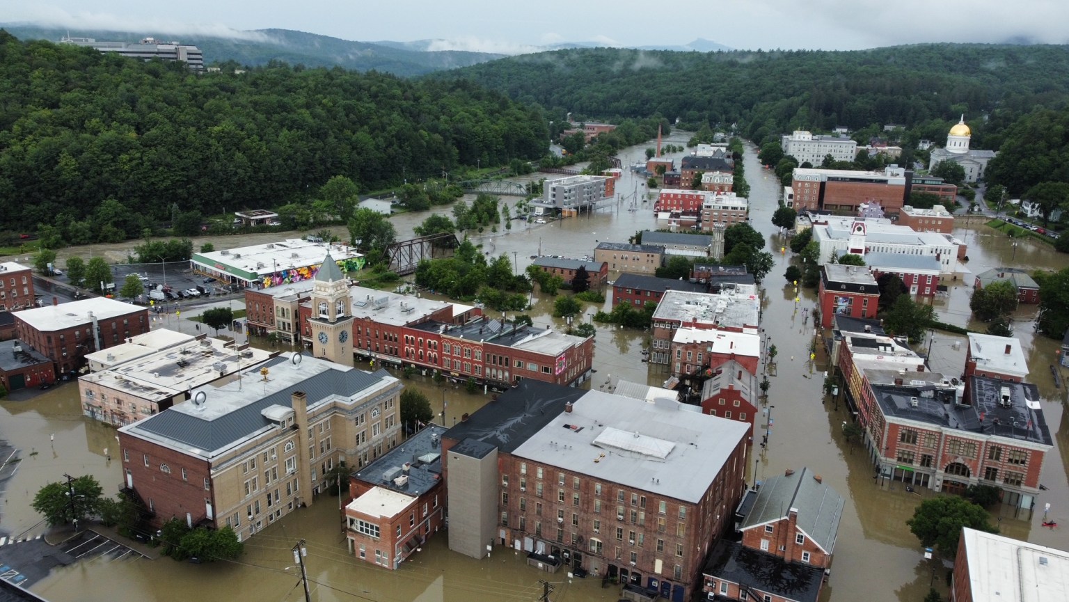
from that article is an shot of Montpelier this morning:
-
2
-
1
-
-
On 7/10/2023 at 7:28 AM, dendrite said:
Still haven’t installed here. lol
I haven't even used fans yet. (granted if I used the window fan it would just suck in the constant rain or the smoke when it is not raining)
-
1
-

Thursday, July 13 - Friday, July 14, 2023 Convection
in New England
Posted
It should be here any minute
https://www.wunderground.com/dashboard/pws/KVTNORWI24