

klw
-
Posts
4,493 -
Joined
-
Last visited
Content Type
Profiles
Blogs
Forums
American Weather
Media Demo
Store
Gallery
Posts posted by klw
-
-
Wow what an awful commute this morning! We started snowing about an inch per hour at home about 5:30am. I left the house at 6:30 and had 1.2 new in that time but was in a slight lull. From getting on I-89 at Exit 2 (mm 13) to exit 5 (mm 41 or so) it was snowing at least 1 inch per hour. At one point north of Randolph visibility was down to about 1/20 of a mile. After exit 5 it lightened almost immediately with almost no snow at all.
There were multiple cars off the road as well
-
 2
2
-
-
BTV's take on the system from the AFD:
From 00Z Saturday onward is where models diverge. While there`s
agreement that there will be some sort of secondary low development
along the southern New England coast Friday night, the strength and
position of the aforementioned surface high pressure north of the
Canadian border remains in question. Where the GDPS was the outlier
the past 2 days offering a stronger high and QPF suppressed across
our central/southern zones and southward, the GFS has now jumped on
board while the latest GDPS has trended slightly north. The ECMWF
remains the most northward solution with the heaviest QPF, but it
should be noted the mean of its ensemble members keep it south
across central/southern New England. So what does all this mean?
Well, while confidence is increasing (quite high actually) that the
forecast area will receive precipitation, confidence remains low as
to where the heaviest QPF will occur. The good news is that the
ptype is currently looking like all snow, with the worst case
scenario being some sleet mixing in across southern VT.
Probabilities from blended guidance for >4" of snow are 60-70%, but
for >8" it drops off to 30-40%. A snow storm with minor to moderate
impacts seems likely Friday night through Saturday with our best
first guess being a widespread 5-8" from north to south.
-
1
-
-
6.6 " for a total here. My dogs managed to run through 2 of the 3 measuring spots but I think the total is good.
-
3
-
-
1.1 so far today.
-
7.0 seems to be the final total here. No sleet ever mixed in so it was a breeze to clear the driveway. very light mist going on but not enough to glaze anything.
-
1
-
-
9 minutes ago, CoastalWx said:
At one point I think the NAM did.
I think it was both on Tuesday for a bit though I can't find the HRRR run off hand. It was in this timeframe I think, BTV cut back its snowfall forecast for my area for a brief time in that frame citing the mesos.
-
1 hour ago, CoastalWx said:
Mesos got the warm tongue. But, they sucked in low levels
They may have gotten the warm tongue eventually but didnt NAM and HRRR show sleet to Canada just 35 to 48 hours out?
-
6 inches on the nose as of 5:30am
-
2
-
-
1 hour ago, BrianW said:
This thread...
Nah it is more like this:
-
 2
2
-
 1
1
-
-
-
20 minutes ago, klw said:
-20f off a low of -22. We often drop at dawn so I will look to see if we go down over the next couple hours. With this not being a radiational based event where the valley is colder than here, I doubt that will be the case.
We briefly warmed up to -18f after the dogs left a couple of steaming piles close to the sensor. Now back to -20.
-
-20f off a low of -22. We often drop at dawn so I will look to see if we go down over the next couple hours. With this not being a radiational based event where the valley is colder than here, I doubt that will be the case.
-
The station around the corner from me is sayin -18.9. Our cheap thermometer says -17.
-
1 hour ago, dendrite said:
What is that in kevins?
Kevins is only used as a scale for the measurement of dews.
-
42 minutes ago, dendrite said:
HRRR is -10F here late afternoon tomorrow. Laced brownies.
That is 249.8 Kelvin, however, which sounds much warmer.
-
1
-
-
21 minutes ago, dendrite said:
-30s dews are fun
Why don't we ever hear TV mets say "It is not the lack of heat, it is the lack of humidity."
-
1
-
-
1.4 new here overnight.
-
worst part of the 94 cold snap was it flipped warm. -25 at dinner to rain the next day and 40s then back below zero.
-
1
-
-
2 hours ago, Cold Miser said:
He ain't wrong.
Well I once had -4F with snow on the ground and light rain/drizzle. So that was worse. I have no idea how it happened.
-
1
-
1
-
-
11 hours ago, klw said:
2.0 inches here, rates have backed off
3 inches total here followed by other which made a crust, 32 f now
-
2.0 inches here, rates have backed off
-
4.8 for the day brought us to 7.8 for the event.
-
-
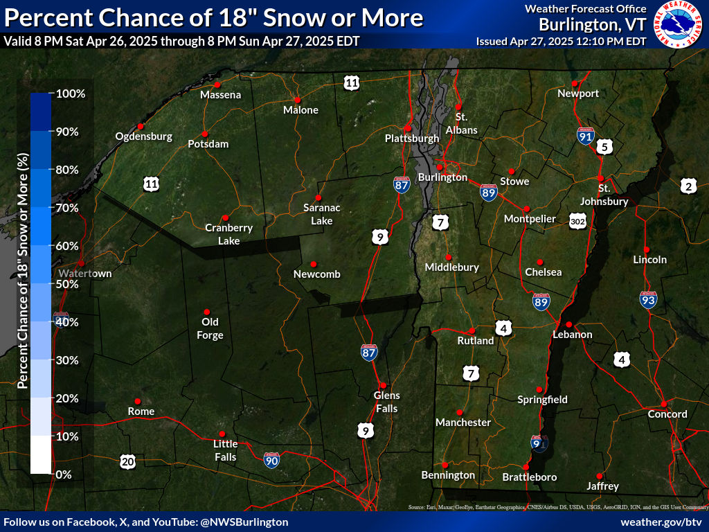
BTV gives me a shot at getting at least 18" out of this. Nice! Lock it in!

-
1
-
March 2023 Obs/Disco
in New England
Posted
I measured 3.0 new when I got home this evening. So 4.2 for the day. I wonder how much it was before compacting the las 8 hours.