

klw
-
Posts
4,487 -
Joined
-
Last visited
Content Type
Profiles
Blogs
Forums
American Weather
Media Demo
Store
Gallery
Posts posted by klw
-
-
11 hours ago, powderfreak said:
You’re insufferable with this stuff in the summer
 . It’s like discussing favorite sports teams instead of the weather.
46 here
-
2 hours ago, Damage In Tolland said:
Appetite for?
Use your Illusion.
-
8 hours ago, powderfreak said:
The eastern slopes of the Greens, in central sections have been Ground Zero IMO. Also some spots of the eastern slopes of the Berkshires. The 10-16" zone is highlighted along the Spine of the Taconics, Berks, Greens and into the larger scale eastern side uplift. In VT it includes the Spine and eastern hills, Orange Hills, into NEK. The SSE low level flow meeting with WNW energy aloft... time and time again. ORH Hills down to Tolland Hills are going to precipitate on that SSE low level flow. The zones getting the max drench all month definitely fit a distinct pattern.
13.48 for July to date here after 8.46 in June 21.94 in 7 weeks.
On the plus side was last night's rainbow:
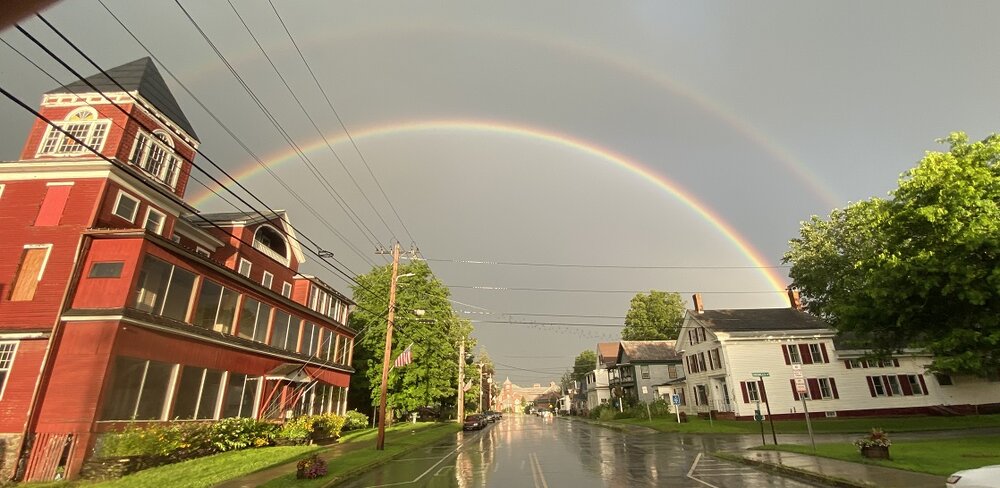
Yes Hyde Park Vermont is hopping at 7:30 on a Friday night. (I stood and lingered in the middle of the road to look)
-
 6
6
-
-
1 hour ago, HIPPYVALLEY said:
What’s the best source for weather related road closures? I’ve heard rumors that parts of Route 2 are flooded out east of here but can’t confirm. I need to travel that way later.
This was invaluable up here of late. I don't know if it as thorough down in Mass.
-
1
-
-
46 minutes ago, Ginx snewx said:
The next time you read about PHX being super hot think of this picture
Plus they live in Arizona and its the summer.
-
 1
1
-
-
1 hour ago, Torch Tiger said:
Ever see Mission of Burma? I got to hang with guitarist Roger Miller a few times about 15 years ago when my band rehearsed at the Sound Museum in Brighton MA. He actually listened to our demos and albums and gave us advice, really good dude and a legend
I missed them. They finished up (at least their original run) before I got old enough to go to shows.
-
 1
1
-
-
8 hours ago, mreaves said:
One of the underrated 80’s bands. Sad ending for Stuart Adamson.
They were the band I always wanted to see live when I was young but never was able.
My only complaint about current country music that I run across on the radio is the amount of autotuning is odd to me for that genre in particular.
-
1
-
-
7 hours ago, mreaves said:
Almost sunny here in Barre.
I'll take ""Rejected TV pilot shows" for 100 Alex
-
1
-
1
-
-
I manged to make it home, some light rain now. 2.41 so far. No issues around the house.
-
2
-
-
16 minutes ago, SouthCoastMA said:
bro country is the best

Big Country was better
-
4
-
1
-
-
T/he 2.31 so far today takes us to 12.15 so far in July after 8.46" in June. 20.61 inches in 48 days,
-
3
-
-
6 minutes ago, powderfreak said:
Also, hard pass on this.
104/90 with HI of 152F. Nope. No thanks.

But have they installed?
-
4
-
-
Looks like the sun is out at home. Worst of the 3rd storm missed from the looks of it. 2.31 total.
NWS issued a Flash Flood Warning.
-
Wife reports backyard is series of waterfalls again with the flat area having more water than last Monday. Town (4 miles away) is dry.
Now at 2.02 inches and another cell has formed behind the first 2.
-
1
-
-
4 hours ago, CoastalWx said:
Looks like flood potential nrn VT into nrn NH
1.5"+ in past 45 minutes at our house.
https://www.wunderground.com/dashboard/pws/KVTNORWI24
-
 2
2
-
-
Looks like our house has gotten over 1.5 inches in past 45 minutes.
https://www.wunderground.com/dashboard/pws/KVTNORWI24
-
1
-
-
1 hour ago, Damage In Tolland said:
1938 wettest July on record in SNE . BDL had over 11” . Already over 9” this month with many more dews and storms to go . That analog keeps showing up. It may mean something
Hopefully not that Germany is eying the Sudentenland.
-
1
-
8
-
-
1 hour ago, mreaves said:
Flash flood warning in VT. It’s not all that close to me but it’s putting on a hell of a light show.

Now it is a flood warning
https://forecast.weather.gov/wwamap/wwatxtget.php?cwa=BTV&wwa=flood warning
Essex NY-Addison VT-Rutland VT- 1008 PM EDT Fri Jul 14 2023 ...FLOOD WARNING IN EFFECT UNTIL 4 AM EDT SATURDAY... * WHAT...Flooding caused by excessive rainfall is occurring or expected. * WHERE...Portions of northern New York, including the following county, Essex. Portions of Vermont, including the following counties, Addison and Rutland. * WHEN...Until 400 AM EDT. * IMPACTS...Flooding of rivers, creeks, streams, and other low-lying and flood-prone locations is imminent or occurring. Numerous roads remain closed due to flooding. * ADDITIONAL DETAILS... - At 1004 PM EDT, Local law enforcement reported major flooding between Schroon Lake and Severance with roads closed at the intersection of routes 74 and 9. Between 2 and 5 inches of rain have fallen. - Additional rainfall amounts up to 0.5 inch are possible in the warned area. - Some locations that will experience flooding include... Middlebury, Moriah, Crown Point, Minerva, Crown Point Center, Port Henry, D A R State Park, Bridport, Shoreham, Addison, Schroon Lake, Orwell, Panton, Cornwall, Benson, Weybridge, Waltham, New Haven, Bristol and Lincoln. - http://www.weather.gov/safety/flood-
1
-
-
https://forecast.weather.gov/wwamap/wwatxtget.php?cwa=BTV&wwa=flood warning
Flood Warning
National Weather Service Burlington VT
1008 PM EDT Fri Jul 14 2023

NYC031-VTC001-021-150800-
/O.NEW.KBTV.FA.W.0025.230715T0208Z-230715T0800Z/
/00000.0.ER.000000T0000Z.000000T0000Z.000000T0000Z.OO/
Essex NY-Addison VT-Rutland VT-
1008 PM EDT Fri Jul 14 2023

...FLOOD WARNING IN EFFECT UNTIL 4 AM EDT SATURDAY...

* WHAT...Flooding caused by excessive rainfall is occurring or
  expected.

* WHERE...Portions of northern New York, including the following
  county, Essex. Portions of Vermont, including the following
  counties, Addison and Rutland.

* WHEN...Until 400 AM EDT.

* IMPACTS...Flooding of rivers, creeks, streams, and other low-lying
  and flood-prone locations is imminent or occurring. Numerous roads
  remain closed due to flooding.

* ADDITIONAL DETAILS...
  - At 1004 PM EDT, Local law enforcement reported major flooding
    between Schroon Lake and Severance with roads closed at the
    intersection of routes 74 and 9.  Between 2 and 5 inches of
    rain have fallen.
  - Additional rainfall amounts up to 0.5 inch are possible in
    the warned area.
  - Some locations that will experience flooding include...
    Middlebury, Moriah, Crown Point, Minerva, Crown Point Center,
    Port Henry, D A R State Park, Bridport, Shoreham, Addison,
    Schroon Lake, Orwell, Panton, Cornwall, Benson, Weybridge,
    Waltham, New Haven, Bristol and Lincoln.
  - http://www.weather.gov/safety/flood
-
Cells seem to constantly be building sw of that area
-
Ripton and Hancock Vt must be getting washed away. This will be really bad.
https://www.wunderground.com/dashboard/pws/KVTRIPTO7
This site up to 2.82 inches and coming down at 2.1 per hour at the moment.
Downstream of there will be hurt too.
I left the Morrisville Hannafords a little after 9 and immediately saw the lightning show. I thought I would be driving right into it but it stopped moving and grew. I was sure I would get caught in it between Barre and Randolph but I out ran it. 1 1/2 hours of constant lightning.
-
Ripton and Hancock Vt must be getting washed away. This will be really bad.
https://www.wunderground.com/dashboard/pws/KVTRIPTO7
This site up to 2.82 inches and coming down at 2.1 per hour at the moment.
Downstream of there will be hurt too.
-
Some thunder, not much wind.
I am tired and heading to bed.
-
1
-
-
And it begins


August model and weather disco
in New England
Posted
https://www.wcax.com/2023/08/04/flash-flooding-washes-out-roads-addison-county/
https://www.wcax.com/2023/08/04/three-people-rescued-car-trapped-middlebury-flooding/
It looks like another round in NYS may be heading towards Middlebury.