

SnowLover22
-
Posts
1,300 -
Joined
-
Last visited
Content Type
Profiles
Blogs
Forums
American Weather
Media Demo
Store
Gallery
Posts posted by SnowLover22
-
-
1 hour ago, wxeyeNH said:
I'm wondering how fast the Gulf surface waters warm back up after the passage of tropical cyclone like Sally. Does a couple of days of bright sun do much in September? Gulf waters must be pretty well turned up. Anyone knowledgeable in this area?
Wouldn't it take a while. The heat capacity of water is high so just "a couple of days in the sun"I feel like would not really warm up the waters that much.
-
4 minutes ago, cheese007 said:
Just leaving this here
listen to the actual video
Direct quote from Levi "the plane is measuring 85-90 mph maximum not really getting up to the 100 mph that was observed earlier".
-
Im pretty sure you would be annoyed as well if someone called you out for no reason. It seems like a normal human reaction.
2 minutes ago, Calderon said:How about you stop taking things overly personal and just let it go already. Relax, because you already went off in the banter thread where it should've stayed.
-
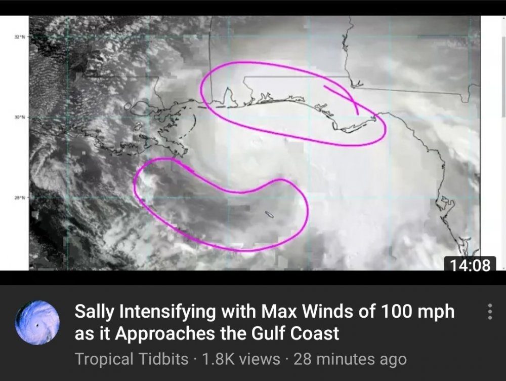
are you guys dense or what? Recon data clearly shows pressure between 987-990mb. Are you saying that is not weaker than this morning because it is. Think before you post. It would serve you well. Also if you actually took the time to look at the data like I did, you would see that recon had higher SFMR data this morning compared to now. Also Levi confirmed in his video what I said so yeah just please think before you post.
-
My college driving up the #s in Ontario County yikes...
-
technically the same storm so ill put it here, looks the storm has reformed in the Eastern Pacific.
-
Just now, the ghost of leroy said:
automated. the GFS will outperform humans
wanna be a professor? just kidding. universities are dying everywhere.
well being a met is my dream job. If I do decide to change it won't be because of one convo on here. I think you can understand that.
-
Just now, Chicago Storm said:
you have to obtain a job in order to make that, which is the problem.
Well its hard to see what the job market is going to be like in 6 years.
-
3 minutes ago, the ghost of leroy said:
you realize you're going to be poor, right? you should probably switch like mappy did.
not true for certain. My PhD met professor I'm p sure makes over 100k a year.
-
5 minutes ago, mappy said:
With all due respect, as someone who too studied atmospheric science, you take the troll bait too easily.
what happened. Did you eventually decide being a met was not for you?
-
1 minute ago, SnowLover22 said:
so questions like this
fake meteorology am rite
What is the thickness of the 900 to 500 hPa layer at Davenport, Iowa?
-
3 minutes ago, Chicago Storm said:
atmospheric science is fake meteorology.
so questions like this
QuoteAt 00 UTC on 15 February 2003, the rawinsonde data from Davenport, Iowa indicated a temperature of -4.9 °C at 900 hPa and -16.3 °C at 500 hPa. At the same time the rawinsonde at Little Rock, Arkansas indicated a temperature of 12.4 °C at 850 hPa ad -17.5 °C at 500 hPa. The distance from Davenport, Iowa to Little Rock, Arkansas is 768 km. Assume the height of the 900 hPa pressure level is at 1480 m over Davenport, Iowa and at 1540 m over Little Rock, Arkansas.
fake meteorology am rite
-
1 minute ago, H2O said:
Non met judging a met
serious question. why would someone with a PhD be making posts like that on the daily.
-
@the ghost of leroy also grow the **** up . I never said to get rid of him. Think before you escalate something for no reason. All I said is his meteorologist take should be looked at based on the type of posts that he makes.
-
Just now, the ghost of leroy said:
lol
lol what do you do.
-
Just now, the ghost of leroy said:
dude, you're a nobody. i'd dump 100's of you before getting rid of turtle. he's made the board interesting dozens of times. it's not about science. this is the internet and we are here to be entertained.
I wouldn't say that moron. I am currently studying atmospheric science in college.
-
On 8/23/2020 at 9:12 PM, SnowLover22 said:
Can meteorologist tags be revoked. Asking for a friend
bump
-
 4
4
-
-
this aged well LMAO
6 hours ago, vortex95 said:The asymmetries in the CDO suggest still some dry air is getting ingested in the W quad. You can see small areas of bursting very cold IR cloud tops just W of the center and a partial erosion of the colder cold tops on the W side of the hurricane. The CDO as a whole is having trouble organizing into a smooth circular pattern with uniform cold cloud tops. Outflow is being persistently restricted in the W quad and doesn't seem to have linked up with the trough over ern TX to provide a large anticyclonic poleward outflow channel that is often key to RI (Harvey and Michael did have strong poleward outflow channels). So even though conditions have improved the last 12 hours, they are not ideal. The patch of dry air in the wrn GOMEX persists. The shear, which did relax during the day Tuesday, was initialized at 3 kt at 00z by the SHIPS output. 06z it has 13 kt and it stays close to this value until landfall. The window of opportunity for RI may be closing.
http://hurricanes.ral.ucar.edu/realtime/plots/northatlantic/2020/al132020/stext/20082600AL1320_ships.txt


-
1
-
-
Ill put this in banter but for what it is worth the HMON is a lot weaker at landfall (around 990mb) at 18z.
-
Can meteorologist tags be revoked. Asking for a friend
-
 7
7
-
-
-
half an inch already since last post
-
Getting slammed right now with heavy rain.
-
16 minutes ago, Floydbuster said:
I just hear alot of season cancel talk on other weather sites and I don't see any evidence of that.
I would like to know the weather sites you look at lol jk. But for real none that I have seen have said that.


Tropical Storm Beta
in Tropical Headquarters
Posted
Definitely but would most likely have to be a pinhole eye. A system with a larger eye would be harder pressed to find the high wind speeds that Patricia produced.