mattb65
-
Posts
4,722 -
Joined
-
Last visited
About mattb65

-
Invest 90E Once 90E forms a clear center of circulation, we should get a better idea of most likely track. Having tracked for the last few days since this threat started to show up in long range models, cone has included misses North and South of the islands but have been coming together to suggest big island is at risk for a cat 1 hurricane or strong TS. The tracks that hit big island also impact the other islands albeit with a significantly weakened storm. Flash flooding and mudslides are generally the biggest risks.
-
One of the remarkable things to me is how well the intensification we are seeing unfold right now was shown on models like the HWRF, HMON and the globals. They've been showing this rapid deepening leading up to landfall for many of the model runs once this track more toward SW FL locked in. Edit: next 6-12 hours before landfall on models suggest this is the peak and going forward will be either steady state or slight weakening before landfall.
-
Yes, combine that dry air with 40 kts of shear and the only natural expectation should be rapid weakening. There are a number of people claiming the rapid weakening is implausible. I disagree. If the TC has extremely dry air from the surrounding environment ingested into the core combined with shear strong enough to decouple the LLC and MLC, then rapid weakening is exactly right and is the reason why it's shown by the most accurate hurricane models. The environment leading to landfall would have to be completely different from what's being modeled for the storm to not rapidly weaken on approach. The tracks taking it toward Tampa aren't impacted as much by the shear in the Northern Gulf, and some that completely miss influence of the trough and stay further south and west in the Gulf might be able to maintain intensity. With the storm all being so disorganized, it's very much a guessing game which track will end up being correct. My main point is that rapid weakening leading up to landfall if it follows the track currently modeled on the HWRF and GFS is not outlandish/wrong as some have indicated.
-
The low level cold is pretty robust and filtering in throughout the storm. This seems to be the recipe for a significant ice event for someone if it comes in ahead of the precip which seems to be the solution models are converging upon. Details on location TBD but seems to be CT up to Rt 2 is the corridor to watch. Hopefully it's IP and not ZR.
-
That area down there on the other side of the coastal front and into the cape is probably going to have some serious tree damage and power outages with the pounding snow and temps in the 30s plus wind.
-
 I was a senior at BC for the Jan 2005 blizzard with drifting to 5 ft blocking the front of our dorm in the morning. Plenty of cars on Comm Ave turned into snow blobs. For Nemo I lived in JP and we had 4 ft+ drifts. If you get 20+ with these winds the drifts will be solid Edit: these are all at close to sea level so quadruple amounts for your elevation as others have noted. /s
 -
Harwich, Cape Cod, MA crushed.
-
Lol I don't want to upset the weenies. Their inner weenie anxieties are high enough without someone living in hawaii bumping up the worst model. I remember going to bed with all the models showing flush hits and waking up the day before a storm with a couple of models pissing in the cheerio bowl. In reality, convective issues can happen and can steal moisture and screw around with cyclone development and precip distribution which is the one big wildcard that won't be sorted out until gametime.
-
This sounding for E MA from the 3k NAM during the height of the storm is nuts. DGZ from the surface to 500 mb.
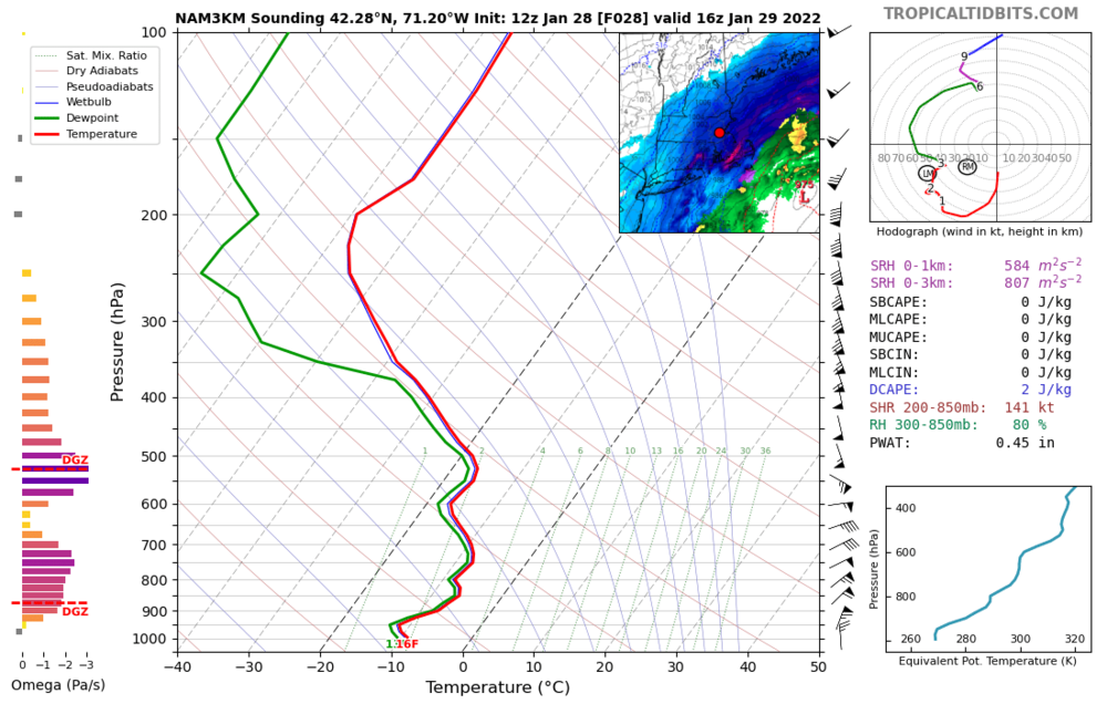
-
Winds and drifting are probably going to make it tough to measure accurately in this storm. Having said that, some of the soundings show an absurdly wide dendritic growth zone with huge lift especially in the deform band area. The ratios and rates for whomever gets lucky enough to get under this band will probably see extreme rates with high ratios. I can't recall too many storms where the snow depth maps are significantly more than the 10:1 ratio maps. Wishing I could be back in Boston for this one.
-
Seems to me that the cone is just narrowing, GFS on the eastern side of the cone and NAM/Euro on the western side of the cone. Either track is possible and the two most likely outcomes are an E MA and Maine special or a more region wide impact. Even the eastern side has a mature cyclone, not some strung out POS so whomever is fortunate to be graced by the ccb or deform is going to be piling up lots of snow.
-
You aren't going to have a 90% guarantee of 24"+ even with a perfect track. Too much uncertainty in where banding will set up to predict who gets 24"+ with that level of precision. I salute you for even considering pissing that many people off to chase a snow storm.
-
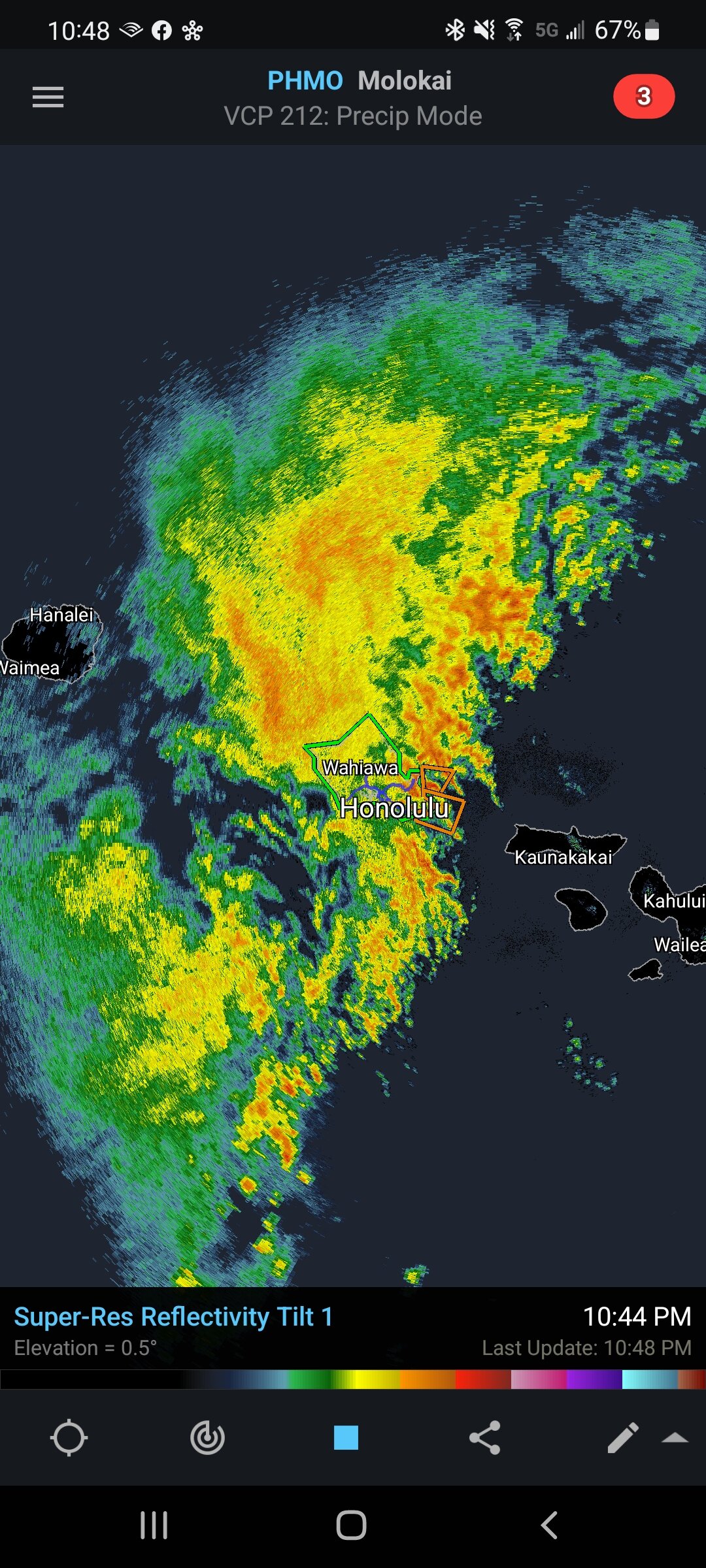
Forecast was for 5-10" with lollis to 20" Up to almost 8" on the day, 9" on the event, still pounding and radar looks like this #firehose

-
Don't worry, we've got your snow in Hawaii. .BLIZZARD WARNING FOR THE BIG ISLAND SUMMITS... HIZ028-040215- /O.CON.PHFO.BZ.W.0001.211204T0400Z-211205T1600Z/ Big Island Summits- 311 AM HST Fri Dec 3 2021 ...BLIZZARD WARNING REMAINS IN EFFECT FROM 6 PM THIS EVENING TO 6 AM HST SUNDAY... * WHAT...Blizzard conditions expected. Total snow accumulations of up to 12 inches or more. Winds gusting over 100 mph.
-
It's a little bit of a crap shoot when a big storm is going to blow up and send a swell but usually late Dec, Jan and Feb are prime. Last year late December had a 20 ft, 20 sec swell with waves completely closing out in Waimea Bay which doesn't happen often, and usually requires 40 ft+ faces. There were surfers paddling and towing in which I can't imagine. Haleiwa is a great town, really laid back. BTW, the storm sending the waves this weekend also triggered the first winter storm watch of the season for the big island but not the first snow. Current forecast is for up to 4 inches with SW winds of 50-80 G100 at the peaks of the big volcanos.