MAG5035
-
Posts
6,054 -
Joined
-
Last visited
Content Type
Profiles
Blogs
Forums
American Weather
Media Demo
Store
Gallery
Everything posted by MAG5035
-
Hey I basically told you the same thing without the cover charge lol
-
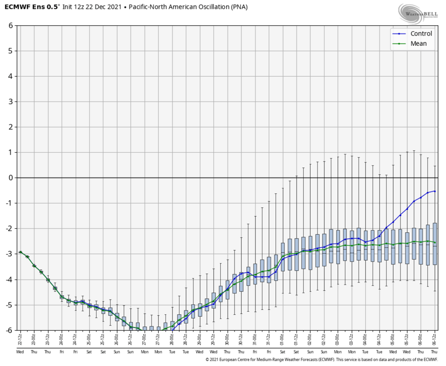
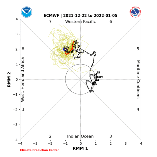
Yea I get the models aren’t showing much digital snow today in the long range and are showing some cutters in the interim but I really don’t share the pessimism of the 12z suite. I see some decent things brewing in the ensemble means. I see the PNA forecasts steadily starting to come out of the hole (below -6 st dev currently) to a lesser negative value or even almost to neutral in the Euro EPS case by the end of the run. EPO briefly touches positive (around the period of the after New Years system) before going back negative. WPO (West Pacific Oscillation) remains negative which means that Pac ridge is going to likely continue to be a fixture. NAO/AO realm not as negative but nothing I see as overly detrimental. If that super -PNA neutralizes even some and we keep our general base state with the other teleconnections, that’s going to broaden what has been a very sharp western trough and allow the cold to push east and level off the SE ridge. Probably not going to be really cold initially unless/until we get an actual western ridge but it doesn’t need to be -20 to snow. This system coming New Years weekend is likely going to be the first thing that allows an actual shot of colder air east in awhile. Just said yesterday the system itself probably cuts (and depending on a kicker right behind it is low probability at best in most cases). We’ll see how the pattern evolves. Individual features/systems in the longer range are background noise to me at this point beyond this weekend system. I’m concentrating at the bigger picture features. The MJO is also starting to edge toward 8 and is finally starting to get into there on some of the model forecasts. With all that business 7-10+ days down the road, I’m also sitting here wondering if the next wave of precip tomorrow night tries to do what this morning’s wave did maybe getting some frozen further south than advertised. The majority of snowfall on that 12z GFS forecast today in northern PA comes from that. Probably looking at a another advisory for the northern counties (potentially for straight up snow) and at least some of the central ones for mix. This is on the other models too (swath a tad further north on most other guidance). Sus Valley probably is gonna be a bit too warm for this one but it’s fairly close to being a second wintry event during a week that had appeared to be to be the warmest/most hostile period in the actual 15 day forecasts.
-
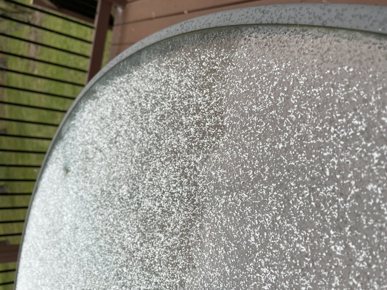
Post clean-up. Temps are above freezing now so looks like icing is going to be minimal. Snow is concrete though. What a nice overachiever this morning. For the lackluster start this winter has had this was still a bigger single snowfall than anything in 19-20.. so things are looking up lol.
-
Sounding the pinger alert here. Sleet and some ZR in there. Final snow total going in at 2.8”.
-
Roads must be a disaster, the mailman has the USPS truck parked on my street and he’s got snowchains deployed on the back tires haha.
-
Today’s a good reminder that we don’t reside at 500mb and those ugly reds at those levels don’t always indicate a blow torch at the surface.
-
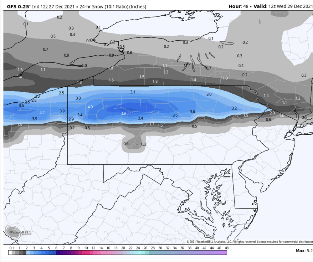
For sure, although the HRRR was showing amounts like this through about it’s 0z run or so last night before it lightened up the initial slug of precip. Looks like the earlier runs ended up being correct with the heavy slug of precip up front. This may be enough to push into the Sus Valley and collapse the column for a period of heavier snow.
-
Slept in a bit this morning, well this was a nice surprise to wake up too. Crushed 2.2” and counting. Heavy snow
-
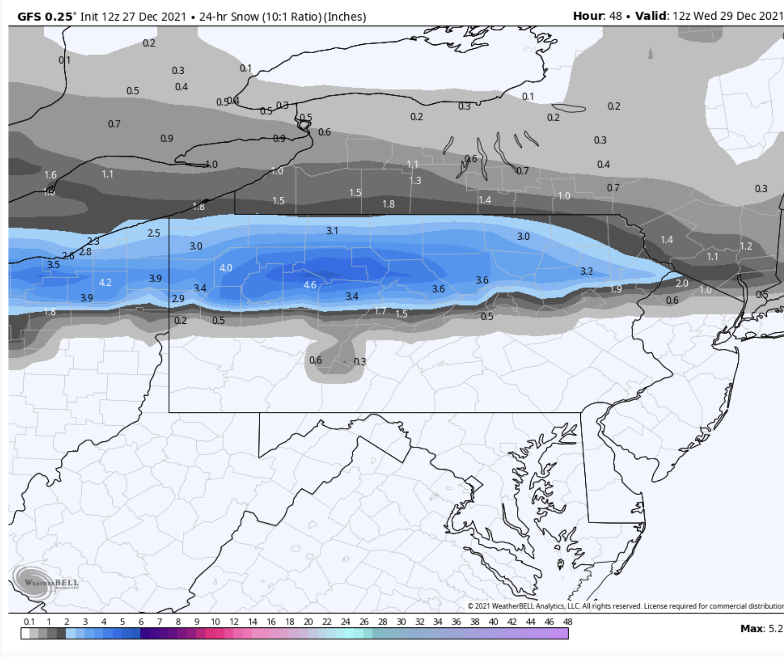
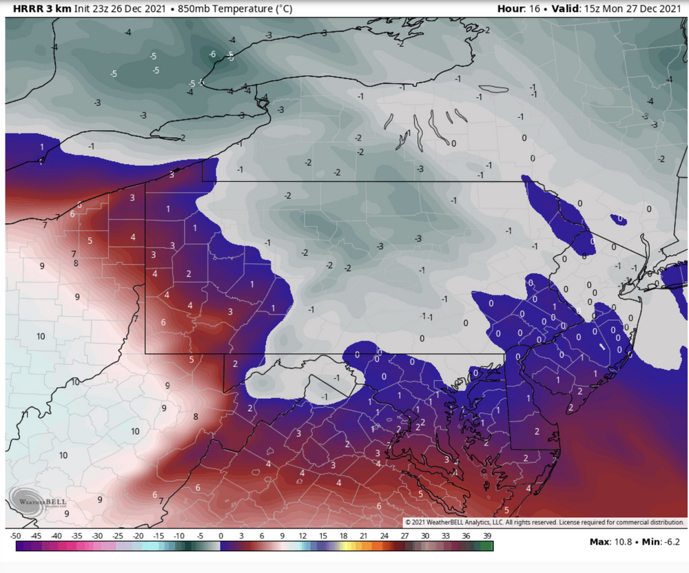
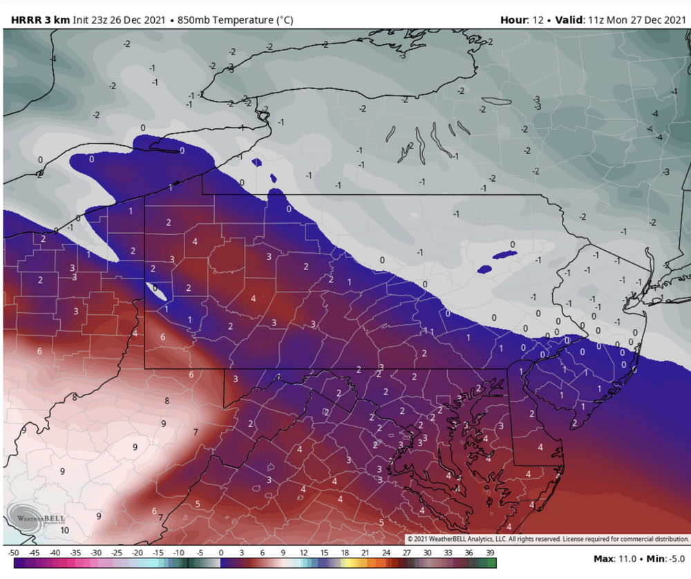
The next run in the HRRR cycle will be an extended one (0z) so we’ll have a look at the full event with that run. The last few regular ones have been pretty aggressive with the lead precip shield, which is needed if we’re going to get a meaningful period of snow/frozen up front. 850mb temps actually are a bit above zero prior to precip arrival, so it’s important to have that heavier precip to get the column cooled before warm advection eventually wins out later tomorrow. Here’s 850mb at Hr 12 right before precip arrives and hour 16 when it has gotten into a large portion of C-PA
-
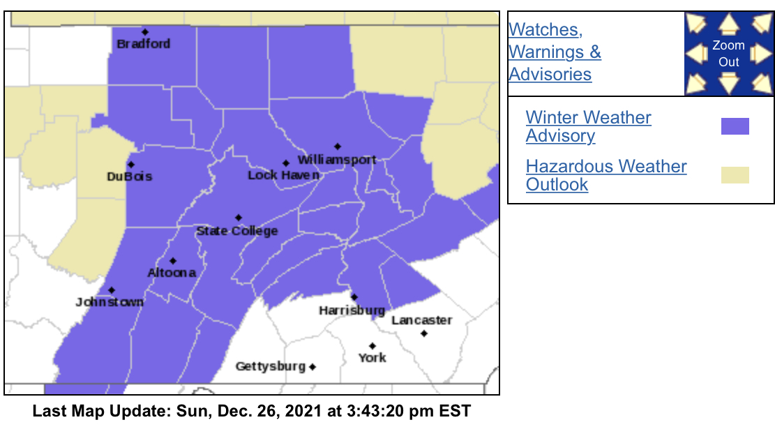
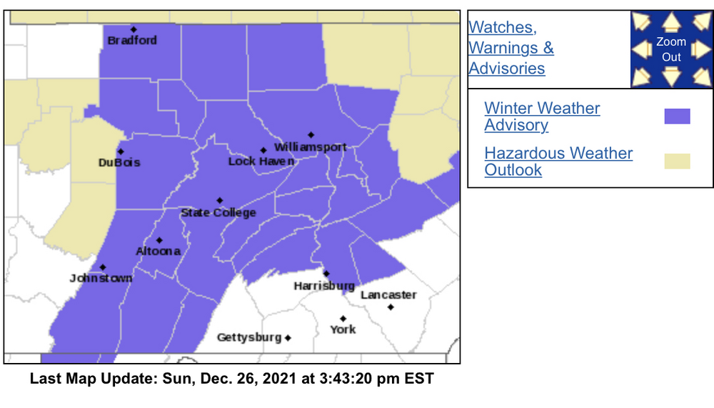
I think the big takeaway from that potential system a couple days after New Years is that it looks like it finally might be a catalyst of a much awaited reshuffling of the pattern that could get cold air more consistently on this side of the country. I don’t think we’ll be well positioned for the system itself however at that point with the southeast ridge still raging leading up to that.. unless we see the evolution with the follow up wave. That typically is a long shot of actually working well for us but it’s certainly possible. This system in general is definitely strongly agreed upon by all the models, though. In the nearer term, we have the first widespread advisory products of the season issued:
-
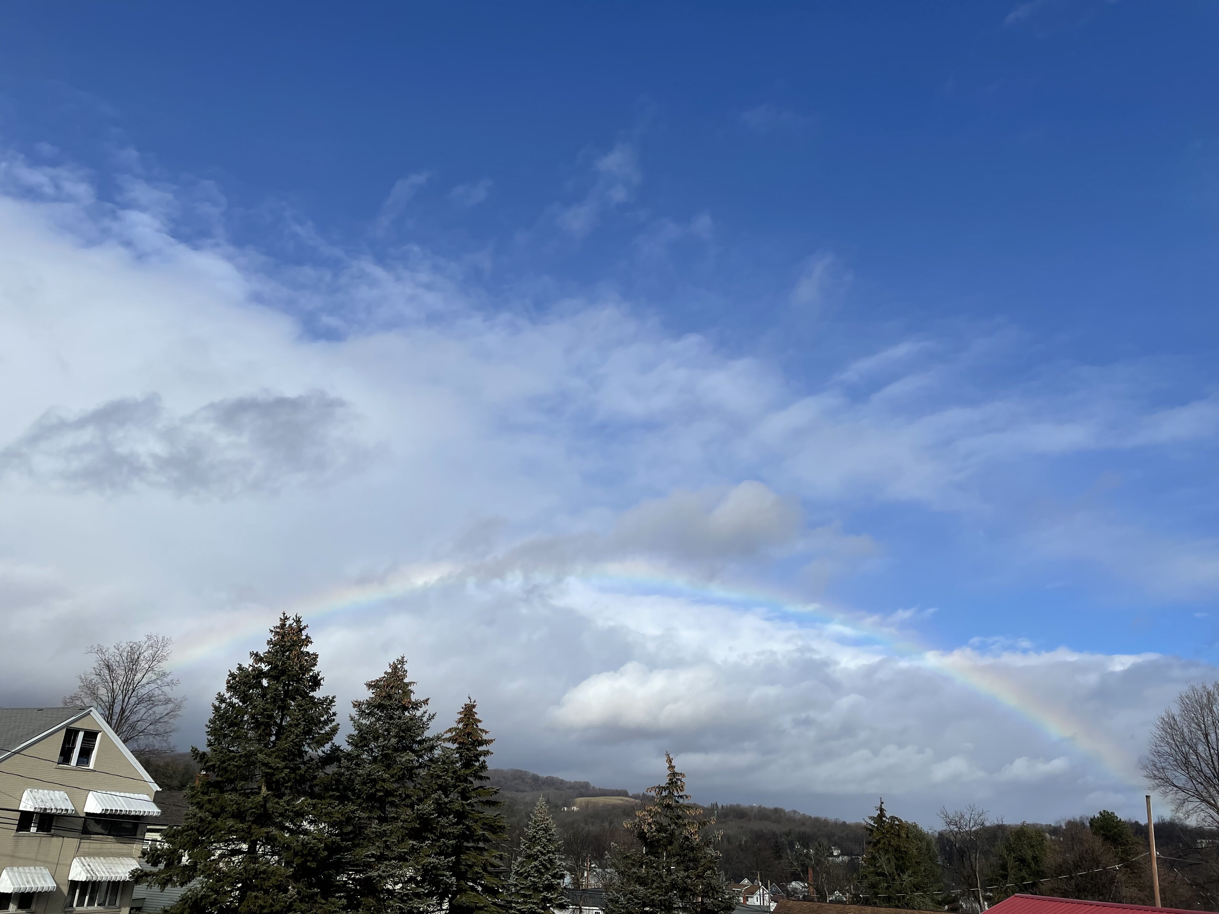
Merry Christmas everyone! It’s been a pretty rainy morning here. We need the rain but it’s pretty blah that we’re getting it on Christmas Day. It also was in the upper 30s til about mid morning, then temps rocketed into the mid 50s. Also had this happen briefly while I was making this post if anyone had Christmas rainbow in their bets for random holiday weather. It’s already now cloudy and raining again. Not sure what to think of this Monday system, I’ve been keeping an eye on it. Seems like we’re going to have two cutting waves in quick succession Mon and Wed. Monday’s has some surface high support for a time, while Wednesday probably ends up rainier (though models have had some different takes on the beginning of that one as well). Gonna concentrate on Monday for now. I tend to think the potential snow burst is going to be brief with this. The column starts marginal, especially at 850mb.. and it’s going to quickly get advected above zero. Could we get a quick inch or two in spots? Perhaps, if it comes in fast with heavier precip and we wetbulb the column down briefly. The upper Sus Valley MDT north seems best positioned for that possibility. This seems like more of a potential several hour period of sleet/freezing rain though, with the best icing potential where it always is.. in the interior central counties of the ridge and valley. NAM had been extremely disinterested in any organized precip at all but the 12z 12k run looked more like the other models. NAM has been warmer in terms of the column though, esp at 850mb. There’s a big time difference between 850 and 925mb in the central counties. For instance Hr 54 at KAOO has -2ºC at 925mb and +9ºC at 850mb. That indicates to me more of a straight ZR scenario. The globals have been colder, which allow for the period of snow and/or sleet. The NAM’s warmer column actually seems like the better bet in this setup IMO, but we shall see. I do think this is going to merit the first widespread advisory event of the season for CTP’s CWA.

-
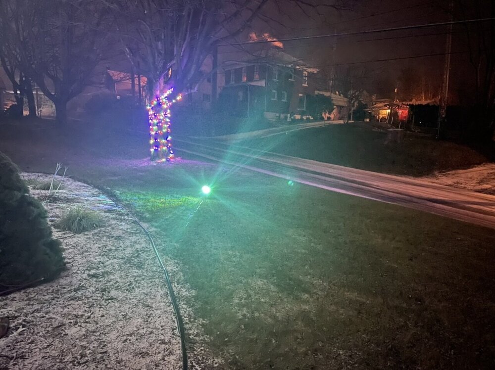
Now officially Christmas Eve this is probably about as good as this Christmas is gonna get in the snow department. A dusting of snow and a semi-caved street.
-
Plot twist, it’s snowing here right now.
-
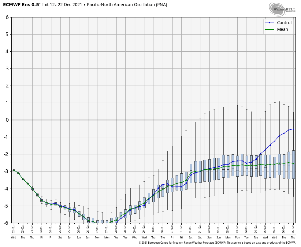
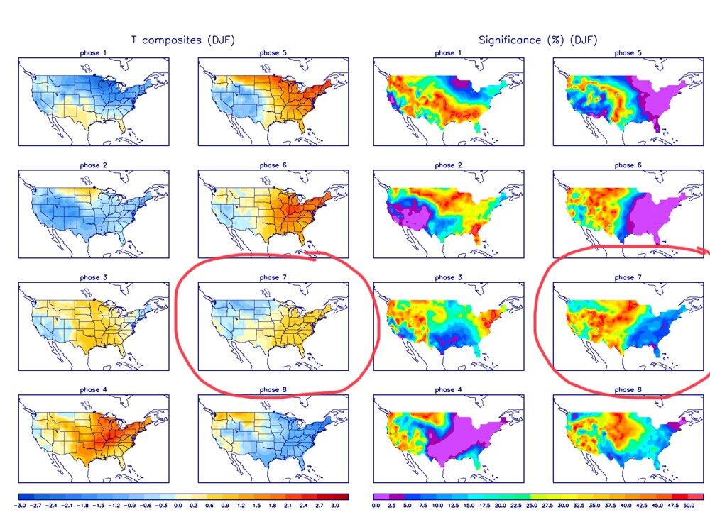
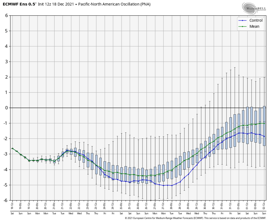
I think the detriments of our general pattern are quite clear at this point. You have the PNA forecast to dip to like -6 or even lower on all guidance the next few days (older Euro shown). Tonight’s GEFS pretty much the same magnitude That’s getting into stupid negative territory.. and it only pulls back up to -3ish in the longer range. This is currently the dominant teleconnection signal for us IMO. The decent -NAO developing isn’t enough to counteract something like that on this side of the country. I went pretty in depth into this in my last post a few days ago on page 63 (24 pages ago already!). So that brings the MJO… Euro is being shown again, but the GFS/GEFS has the same general theme. That’s a whole 15 day forecast stuck in phase 7. Several days ago we had more movement towards or into 8. Now we don’t.. which I think plays into the whole seeing the pattern change 10+ days out “never getting closer” in range on the operational guidance. Phase 7 for the east isn’t the blowtorch phase that 4-6 is this time of the year, but it is not ideal. I’m applying the DJF average since we are getting close to January… and quite frankly it just fits the current situation better. Look familiar? To refresh on these maps, the one circled on the right is a correlation map. Basically, places on the blue and purple end of the spectrum show a high correlation to the what the temperature pattern shows whereas the reds and oranges indicate a lot of variability. So you can see the east is mostly warm in this phase but not to the extent of 4-6. As I see it, I believe the MJO is having a pretty big influence on the overall pattern given that it has been at a pretty decent magnitude.. especially driving that Pac Ridge into Alaska. If you loop through the 500mb on ensemble guidance (like tonight’s 0z GEFS for instance) you’ll see how remarkably stable the significant features are (Pac ridge, western trough, NAO blocking, etc). To me it just sort of all lines up that these things aren’t shifting along with the tropical forcing (MJO) being stuck in Phase 7 and continuing to be forecast to remain there at magnitude. These are pretty anomalous features too, especially on the Pacific side. The NWS in San Diego forecasting 1.5-2” of rain in San Diego metro with 3-4”+ in the surrounding hills from later today through Friday eve is generally not how you run a Nina down in southern Cal. The unsettled and very wet pattern is definitely greatly needed out there although that much rain is going to cause flooding problems in that particular region. It’s just how the playing field ended up setting up and there’s not much you can really do about it. If the MJO would’ve decided to take a seat for a month in Phase 8/1 I’d wager we would be having a way different discussion right now. I don’t see us as completely shut out on opportunities, but we’re going to be limited until this pattern gets jolted in some fashion. Even just relaxing the West Coast trough (aka neutralizing the PNA some) would likely help a lot if we keep the -NAO/AO/EPO, which has also been showing longevity in the longer range ensemble forecasts as well.
-
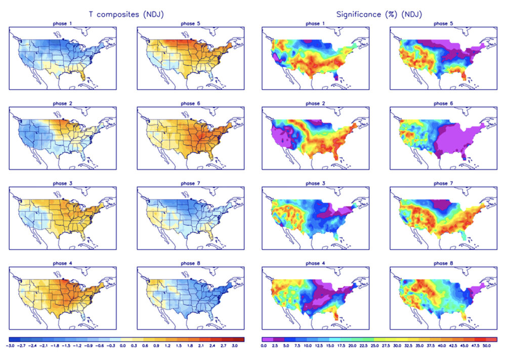
Well I started the thread that year starting right at this time of December haha. I know it doesn’t mean squat if the goods don’t start piling up in everyone’s yards but fundamentally we’re way different than 2019-2020 so far. The dominant thing that completely derailed pretty much that whole winter (really starting in January) was a relentless record positive +AO and +NAO that in the case of the former with a record strong PV, kept cold locked up well north a majority of the time. That ugly prognosis was starting to become evident on longer range modeling about this time in December and especially the last week or so of the month that year. At any rate, I said right at the beginning of the month when it was looking like things we’re going to backtrack during the mid-month timeframe that this taking til after the holidays was on the table dependent on the MJO. Looking at todays forecast, we’re still stuck in 7 for at least several more days. I’ve also mentioned that even though that phase for NDJ skews a bit cold for the northeastern US, there’s not a high correlation to it definitely being cold.. or at least significantly so. This transitions to skewing towards a warmer eastern US and cold western US when applying the DJF three month average. Basically, what I’m seeing in terms of modeling the next 7-10 days or so makes sense to me with regards to that, and the following discussion is speaking most directly towards the next 7-10 days. The big issue I see is this, and it’s kinda being somewhat overlooked in here.. or least it feels that way. I’m using the Euro ensemble there but it’s like that on all the major ensembles. That’s a pretty strong -PNA. The good thing is we should have the -NAO and -AO blocking, as well an -EPO although it looked like the Euro EPS and GEFS differed a bit on magnitude. The -EPO is good (the ridging into Alaska) because that turns the source region of air away from Pacific origin to being of Canadian origin and also allows the colder air to press. Unfortunately with a -PNA/low heights in the western US the way it is.. the main part of that cold at least initially presses there and not so much on this side of the country. The NAO/AO blocking is going to help though, which is why we’re going to at least be seasonable for Christmas week but probably not really super cold. From a storm standpoint I see there being a disadvantage of separate streams (weaker systems) or if one amplifies some that we get cut… which is what the operational models are showing. We could get some kind of winter event but it’s probably going to be a weaker one. As I see it we need to obviously keep some -NAO/AO and either shift the PAC ridge axis east or build the ridge to the West Coast… which I think happens when we finally boot the MJO out of phase 7. Overall, I still remain optimistic we’ll get a period of what we’re looking for. If I wasn’t optimistic about it you guys would know.
-
Yea I mean as @Blizzard of 93 said, MDT’s average high temperature is still in the 40s and it doesn’t drop below 40ºF till December 31. And then 12/31 - 2/4 is the period of the year where MDT averages under 40 for a high, dipping to about 38ºF at the coldest. So # of 40ºF+ days isn’t really going to tell one much in December. Maybe the # of days of 60+ for a high or something like that, which we’re going to have at least one of those tomorrow. I know it seems like we always have high expectations for deep winter in December but more often than not it really doesn’t go that way.. or if we do have a wintry period it’s often offset by a significant warm spell somewhere in the month. It’s definitely been mostly mild this month so far but nothing I would consider historically warm… and alot of us have had dry and chilly nights as well. We certainly haven’t had say a Dec ‘98 type warm spell. For comparison, UNV was in the mid-high 60s 7 out of the first 10 days of the month that year, with two of those days cracking 70ºF. MDT had FIVE STRAIGHT DAYS of 70+ for a high from 12/3 to 12/7 with 75ºF being the peak on the 7th. On the other hand while our weather here in C-PA hasn’t been particularly crazy this month at least so far, the tornado outbreak last Friday in the Midwest and todays severe line of storms in the Plains (warning statements with 95mph storm motion) along with hurricane force wind gusts in a handful of mid-upper plains states (triggering wildfires in Kansas) is absolutely insane. This was a very extreme past week in weather for portions of the US. Also insane.. super typhoon Rai. Why’s that matter here? That’s likely what’s currently screwing the MJO up… “stalling” it instead of progressing where we want it go (through 7 into 8 preferably)
-
The big issue I see with the overall pattern getting into the second half of the month is despite nice trending on teleconnection forecasts with the EPO in the process of flipping negative,an eventual development of a -NAO (though looked more east based) and a AO being neutral/somewhat negative (more negative as time goes on with GEFS), the PNA is forecast to stay really negative throughout the period on all models/ensembles. The EPO going negative will take away the overwhelming Pacific air source region and allow the cold air to push into the US, but the western trough (-PNA) implies southeast ridging in response. For us, the opportunity is there for a well timed system to give us maybe our first decent event of the season (such as what the 18z GFS has near the 21st). It could also not materialize at all or it could and get wiped out by a warmer system as the aforementioned pattern alignment probably puts the storm track pretty close to us. We need west based negative NAO/eastern Canadian blocking to force significant cold into our area if we’re going to work with a -PNA. MJO plays into all this as well, forecasts “backtrack” the MJO towards or even back into a 6 for a time before making the move to 8. Not a very big MJO expert but tropical forcing/convection takes time to make a pattern response in the mid-latitudes. I do read JB here and there when I’m using the Weatherbell stuff and he did point out the typhoon tracking towards the Philippines. That extra source of convection (in the Phase 6 region I believe) is the cause of the MJO chart showing that “backtracking” toward 6. With regards to the MJO I think we need to see the definitive move to 8 before we see some more significant cold in the pattern for us, and that could take some time. Again like I said the other day, I think the pattern we’re looking for is coming but it could come after Christmas.
-
The biggest severe threat is likely to be the gusty winds with the frontal passage and associated narrow band of heavy rain/thunder that is currently just west of Pittsburgh. SPC only has a marginal threat in western PA and SE PA. A lot of central PA east of the Alleghenies with the exception of the southern tier LSV has remained stable and cool air dammed all day. SPC does have a 2% tornado threat in SE PA.. which is probably the best area to advect in warmer, humid air and tap what will probably be really meager (if any) CAPE to go with the increased shearing near the frontal passage. Something to watch maybe York/Lancaster. Otherwise, I’m not super concerned other than just the general high winds we’re going to see late today.
-
Lol, definitely an elevational component to this storm with the Laurels cashing in on the huge jackpot.
-
Crushed Heavy flurries and 31°F

-
The NAM appears to continue to be leading the way with the Wednesday system having much substance in terms of snow amounts across PA. The 3k version even has the 1-3” swath running more NW across northern PA. Today’s Euro does actually jive with the NAM with the swath placement, there’s just not a lot of QPF. More of a T-1” event with focus above the southern tier and LSV. GFS/Canadian pull the focus to the developing weak coastal low taking best precip and potential snow through the northern Mid-Atlantic/DC folks. Given the pattern I could see the cold not pressing south as much with todays frontal passage and seeing an eventual result more towards the northern solutions being presented, which I suppose is good in the short term and getting some kind of minor + snowfall in C-PA but unfortunately this overall pattern we’re facing going into at least mid month is not looking good for everyone’s cold December forecasts. I was also one that expected a quick start, though we did have some cold weather and a bit snow in the latter parts of November. Teleconnections looks atrocious with pretty much all of them opposing what we need (-PNA/+EPO/+NAO/+AO etc). One of the key things I mentioned in a previous longer post about the pattern is we need the PAC to be more supportive this winter as we can’t depend on the kind of extreme -NAO/-AO blocking that helped counteract a Pacific pattern that often wasn’t very supportive. So mid month is looking pretty toasted save for maybe that weekend system providing some kind of changeover thing behind it. Regardless, any cold isn’t sticking around in this pattern. How long this lasts probably depends on what the MJO does, as it is becoming of a stronger magnitude that should be a more significant driver in the overall pattern…especially in the alignment that’s being forecast teleconnections wise. Some models have been wanting to mire that in the Phase 6 or Phase 6/7 border range before maybe starting to shoot into 7 towards the end of the medium range (basically getting near X-mas week). As it’s been talked about here and elsewhere, Phase 7 for the NDJ three month avg period is a colder phase for most of the lower 48, in stark contrast to Phase 6.. which is NEVER a good phase for the eastern CONUS at any point in the late fall or winter. Also an aside on Phase 7 around our part of the country, a deeper look into those significance % maps that go with the phase temp maps suggests a lot of variability in the eastern US vs say like the north central. Basically what I’m trying to explain is a flip to cold isn’t necessarily the slam dunk here that it probably is in the northern plains. A lower percentage on the significance map (the blues and purples) are stronger correlations to the temp pattern presented for each phase, which are based on historical cases. Phase 6 always presents basically the strongest case of “if it’s in this phase, the eastern US is toast”. So the MJO has been into Phase 6 for the last few days, which we are going to be seeing the influence of later this week as the EPO goes way positive to go with a pretty negative PNA. It seems the GFS/GEFS get it into 7 faster than the Euro/EPS, which is the one that keeps it mired in the 6/7 border longer. The latter is probably not going to flip our pattern to cold and you’d probably want to see it start steadily progressing 7 heading towards or into 8 (a better NDJ cold phase for the NE) to actually see what the 12-15 day range of the GFS has been showing. For the record I do still think we’re going to get the cold/wintry period we’re looking for down the road but we’re going to have to navigate this lousy period and however long it lasts first. Hopefully we won’t have to wait til after X-mas but that’s unfortunately a possibility on the table at the moment.
-
Yea it’s a pretty robust band coming. There were actually some lightning strikes detected with it when it was near Cambria/Blair counties. I’m not home the next day or so but It looks like it’s delivering a fresh coating of snow over in Altoona. Here in NW Huntingdon County there’s not much going on at camp. The elevation here is only about 800ft or so and I think it’s just a bit warm. Just a few miles away towards US 22 at Water Street it’s trying to lay on the road looking at 511PA cams. I’m sure up the mountain where we hunt is a different story, here was a pic from this morning up there. Measured about 1.2”. My cameras at home looked like they had a similar amount (which mostly had melted this afternoon). From this morning:
-
Just mainly some light snow so far with a light coating. Nice to be back in action with the winter events.
-
I’ll be reporting here and there overnight and tomorrow on the proceedings tonight, just from camp in NW Huntingdon County. I’m expecting a general 1-2” here and over at home in Altoona. 511 cams already have snow covered roads up in Cambria (219 corridor near Johnstown).
-
He just did his wintercast the other day that I just watched through. Top three analogs, 05-06, 08-09, 11-12 with 05-06 being the strongest. Calling for the cold December like most and meh the rest of the winter. It’s a 20 min video, he starts into the actual forecast part at about the 16 min mark lol. https://www.wearecentralpa.com/weather/weathercast/wintering-weather-a-your-weather-authority-special/