MAG5035
-
Posts
6,054 -
Joined
-
Last visited
Content Type
Profiles
Blogs
Forums
American Weather
Media Demo
Store
Gallery
Everything posted by MAG5035
-
Central PA Winter 25/26 Discussion and Obs
MAG5035 replied to MAG5035's topic in Upstate New York/Pennsylvania
I think your in a good spot to be a winner for that inverted trough band. -
Central PA Winter 25/26 Discussion and Obs
MAG5035 replied to MAG5035's topic in Upstate New York/Pennsylvania
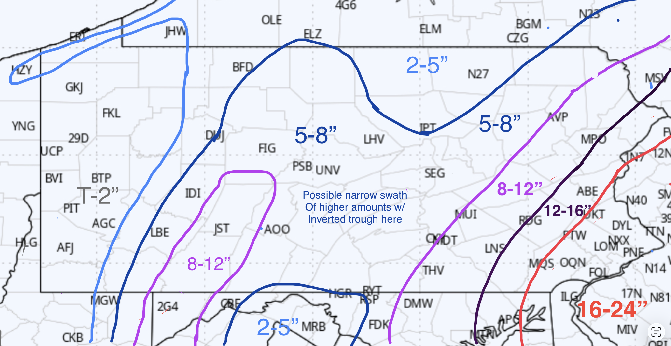
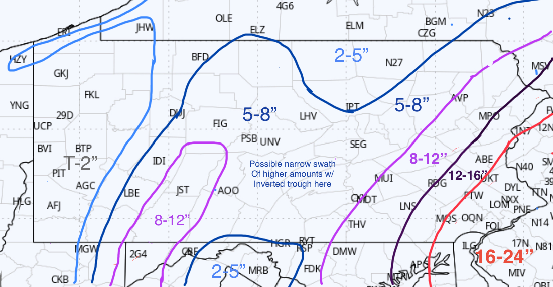
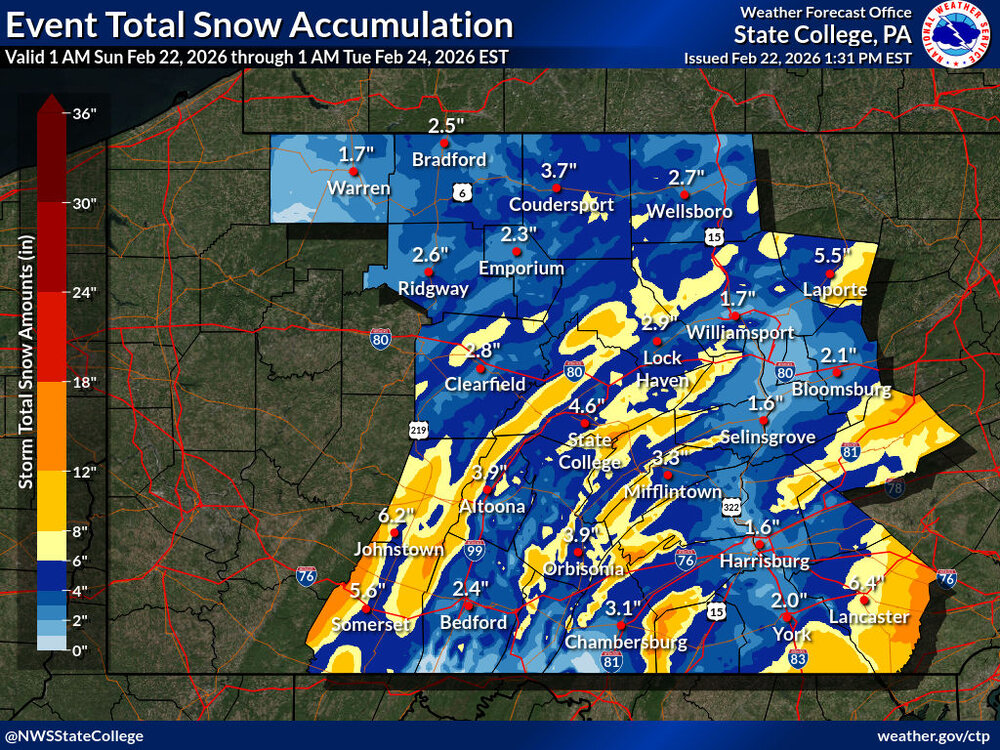
Revised map, I left some room for this to end up a bit better than where the trends are heading but I might not have backed off enough. Totals include what snow has already fallen. Also here’s CTP’s revised snow map, very elevational now.
-
Central PA Winter 25/26 Discussion and Obs
MAG5035 replied to MAG5035's topic in Upstate New York/Pennsylvania
I know I said I was only doing one snowmap, but I’ll be making a revised one here while we’re still early. I wasn’t home all morning but I measured 1.3” at my parents hours 4 miles up the road at 10am, pretty similar to what it looked like here. That has melted some with temps above freezing and really light rates, so I cleared my measuring surfaces. Got some nice returns that have developed overhead in the last half hour, just needs to translate to the ground more. -
Central PA Winter 25/26 Discussion and Obs
MAG5035 replied to MAG5035's topic in Upstate New York/Pennsylvania
34ºF and about 1-1.5” on the grass/decks here, not much precip falling at the moment. Very wet snowfall. I saw some of the early 6z stuff come out before I went to sleep early this morning and I wasn’t too enthused with the trends. The more robust guidance is now fading the coastal low pretty hard after it only just reaches off the Delmarva. Banking on that low coming in closer was a key part of me bringing back the higher amounts further into the Sus Valley on my map, but I did reflect my thoughts on that as well as surface temp issues during the daytime portion of this event. Short range/high range seems to be zeroing on the inverted trough band centering somewhere between here and Harrisburg. If the steadier stuff developing just east of I-99 doesn’t push back this way some this afternoon I’ll be sunk for getting anything near a warning total. -
Central PA Winter 25/26 Discussion and Obs
MAG5035 replied to MAG5035's topic in Upstate New York/Pennsylvania
Pretty good start so far… moderate rate and 31ºF. About a half inch on non paved surfaces. -
Central PA Winter 25/26 Discussion and Obs
MAG5035 replied to MAG5035's topic in Upstate New York/Pennsylvania
Haha I’m glad someone said something, I fixed the original post so it should be visible there now too. Also, snow has started here. -
Central PA Winter 25/26 Discussion and Obs
MAG5035 replied to MAG5035's topic in Upstate New York/Pennsylvania
Let me know if you see it.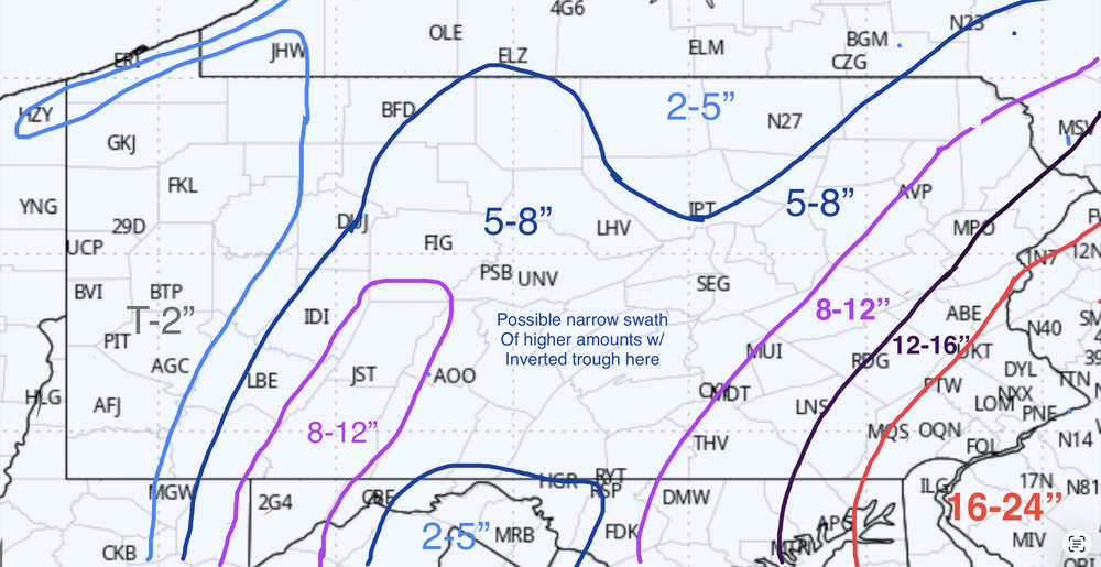
-
Central PA Winter 25/26 Discussion and Obs
MAG5035 replied to MAG5035's topic in Upstate New York/Pennsylvania
CTP’s sending it, remaining watch area to warnings and a few extra north central counties in it as well. 4-9” . -
Central PA Winter 25/26 Discussion and Obs
MAG5035 replied to MAG5035's topic in Upstate New York/Pennsylvania
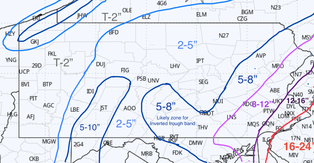
Alright here’s my one and only map for this storm. Tried my best for a blend of things. My concerns from my post earlier are still valid and noted here as well.
-
Central PA Winter 25/26 Discussion and Obs
MAG5035 replied to MAG5035's topic in Upstate New York/Pennsylvania
32/28ºF with the initial precip on the doorstep here. -
Central PA Winter 25/26 Discussion and Obs
MAG5035 replied to MAG5035's topic in Upstate New York/Pennsylvania
I’m gonna throw out a map at some point I think, though I better do it soon since it looks like the first snow moves into the central counties by 12-2am. Might wait to see some early 0z stuff. I still consider the bust potential at least moderate in the corridor between I-81 (including Harrisburg metro) and the Laurels. Rates will be crucial with the first half or so of this event occurring during the daytime in that area with the temps near freezing. High res models kind of hint at this with their more elevational look to snow totals in the ridge and valley. On top of all that is that this is the region of central PA most likely to see that inverted trough related band set up somewhere. That feature’s about the only thing the Euro has been modelling consistently with this system. I think where that sits the longest will put down a narrow stripe of 8-12” within what I currently think will be a general 4-7” for this corridor. Still definitely some bust potential for York/Lancaster counties as well in terms of the top end potential. Obviously short term/high res guidance like the HRRR and NAM throttle this part of the Sus Valley, while the globals do not. GFS has tightened a bit, only clipping the far end of Lancaster with double digits. I’m weighing a bit more toward high res stuff at this point but this is where how far inside that coastal low can get becomes very important. -
Central PA Winter 25/26 Discussion and Obs
MAG5035 replied to MAG5035's topic in Upstate New York/Pennsylvania
I was wondering what they were going to do about the non-watch counties between the Sus Valley and the Laurels, since there’s more than modest support that a low end warning can be achieved. Somewhere between here and Harrisburg is also where that NORLUN feature is most likely to set up as well. Looks like Perry and Cumberland went right to the warning. -
Central PA Winter 25/26 Discussion and Obs
MAG5035 replied to MAG5035's topic in Upstate New York/Pennsylvania
The GFS is still the furthest NW of any guidance, tucking the low back nearly ashore in Ocean City, MD before the fade to the benchmark…which is even more than the NAM. Unless the new 0z Euro pulls a fast one here in a bit we’re still looking at the same US vs Non-US modelling battle for another run. Things are coming much more in line across the board in favor of the bombing coastal, but Euro/Canadian has been taking this more direct from the Outer Banks to the benchmark with less of a tuck back toward the Delmarva. And that’s the key to both the more excessive totals and also getting any kind of double digit stuff back into any of the LSV. -
Central PA Winter 25/26 Discussion and Obs
MAG5035 replied to MAG5035's topic in Upstate New York/Pennsylvania
My thinking on this right now is all of C-PA is looking good for at least a higher end advisory event to low end warning totals in the LSV where the watches represent currently. Basically a 3-6” event for everyone is my general baseline right now. NW of I-81 the key to easily meeting or exceeding that range relates to the inverted trough and the meso banding associated with that… as well as how well the initial precip develops as the features start to phase in. For I-81 and points southeast exceeding or perhaps significantly exceeding warning criteria becomes more related to how close the bombing low tucks in towards the Delmarva coastline. If there are going to be excessive totals with this (18-24+ type stuff), I think the low would have to take a track from interior NC THRU the Delmarva and up right along the NJ coastline for that theoretical swath to make it deep into the Sus Valley. Which probably isn’t going to happen. We have a good 500mb western ridge alignment but the axis is a bit east of Boise (ideal C-PA ridge axis). So I do think this low probably will stay a little bit offshore. I think York/Lancaster have the best chance of seeing anything double digit in our subforum, or Chester obviously since we do have a regular in here from there. Modeled trajectory now generally takes this rapidly developing low up from roughly Hatteras, up just offshore of the Delmarva, tucking to varying degrees depending on model, and then fading east to the benchmark (40/70). It’s easily meeting the criteria for bombogenesis on most guidance now, with the 3k NAM deepening 41 mb in 16 hours. The most intense banding would stay pretty tight with that rapid intensification scenario and track. The inverted trough is what keeps the light-moderate going back far into PA, which is aided some of course by this coastal being closer in than what most non-GFS guidance had until well..today. If we didn’t have that feature but still the rapidly bombing low we would have a truly sharp cutoff between a lot and nothing, which would probably reside right in the middle of the Sus Valley. -
Central PA Winter 25/26 Discussion and Obs
MAG5035 replied to MAG5035's topic in Upstate New York/Pennsylvania
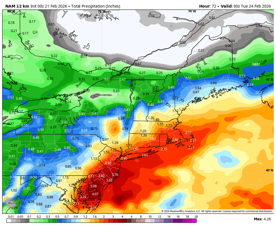
Well that was one of the more absurd NAM-ing’s I’ve ever seen over in Delaware/NJ/Philly/NYC. Wow.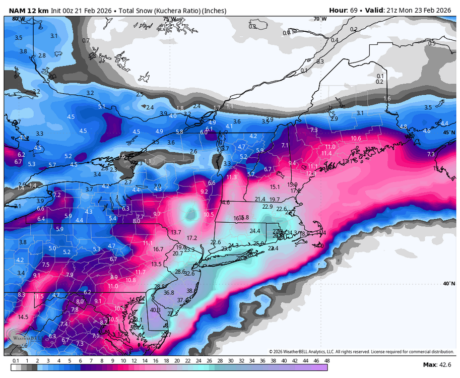
-
Central PA Winter 25/26 Discussion and Obs
MAG5035 replied to MAG5035's topic in Upstate New York/Pennsylvania
At some point soon something’s gotta give with this US vs non US guidance in terms of the top end potential. GFS and NAM totals would be an all-time snow event for the Delmarva and at least a top 10 type event for NJ and NYC. -
Central PA Winter 25/26 Discussion and Obs
MAG5035 replied to MAG5035's topic in Upstate New York/Pennsylvania
I saw videos earlier today of the ice on the move on the West Branch at Renovo. https://www.facebook.com/nova1962/videos/818644964578280/?idorvanity=105222725398 -
Central PA Winter 25/26 Discussion and Obs
MAG5035 replied to MAG5035's topic in Upstate New York/Pennsylvania
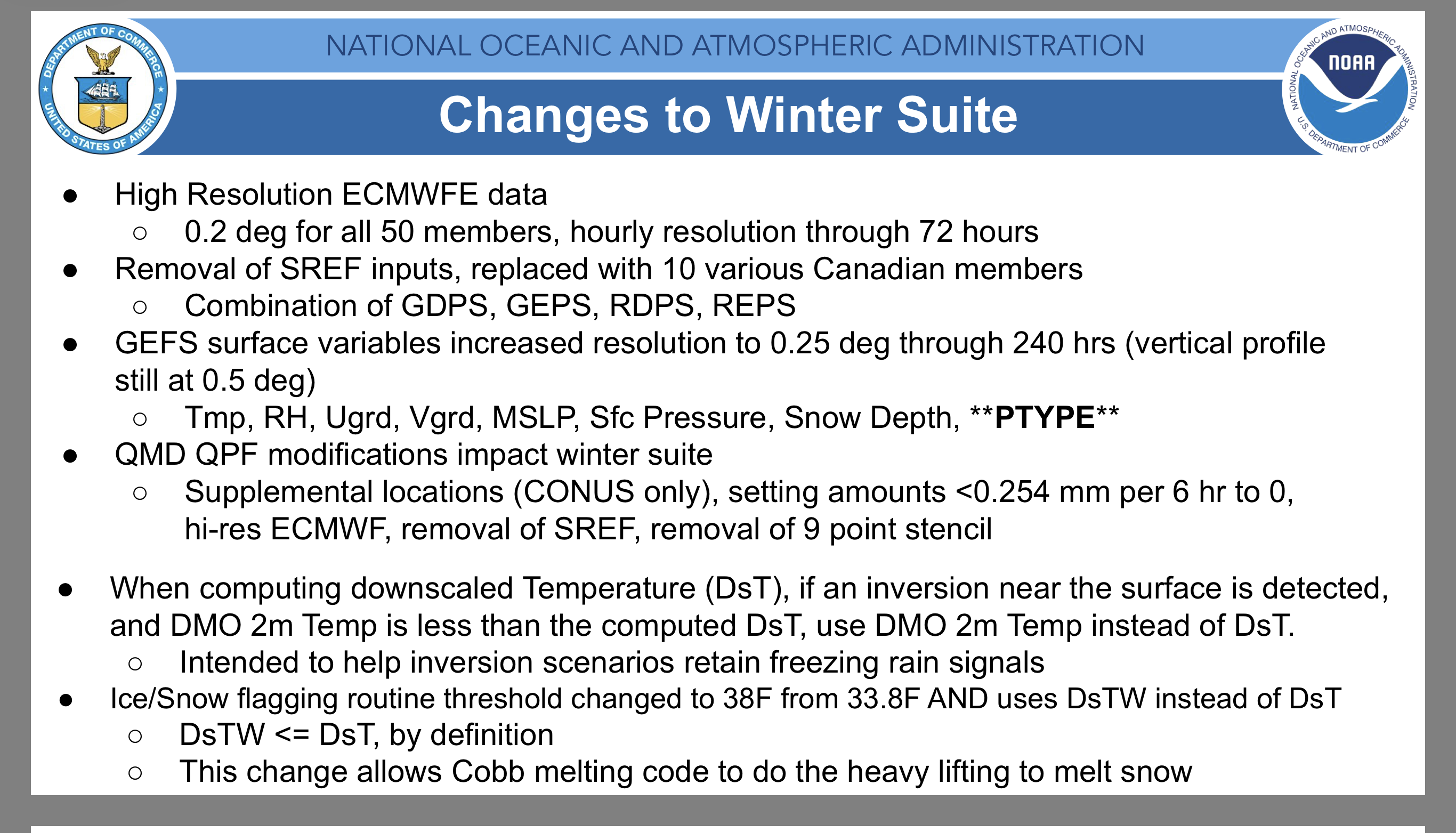
It looks like they are factoring the NBM in pretty heavily into their forecast, which is probably the best move right now. That’s a comparison of the regular NBM and the v5 NBM which is the parallel one that is eventually going to be the regular operational NBM this spring. The v5 version doesn’t incorporate SREF due to its impending retirement I believe at the end of the year. Actually I’ll just show the relevent slide from NOAA’s presentation on the v5 as to the differences in it and how the blend is made up. https://vlab.noaa.gov/documents/6609493/7858320/NBMv5.0+Overview+for+Evaluation.pdf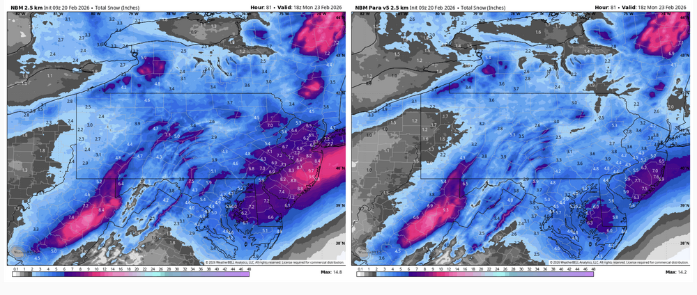

-
Central PA Winter 25/26 Discussion and Obs
MAG5035 replied to MAG5035's topic in Upstate New York/Pennsylvania
It is trying to tuck the low more than 12z and it def made a big step closer to the GFS once it’s further out to sea. GFS still earlier with phasing/storm development that translates to the big amounts it puts out. Main mechanism for us is still the inverted trough, which was more robust with that run. Our “benchmark” for a coastal low is on top the Delmarva or at least right along/near the coast. -
Central PA Winter 25/26 Discussion and Obs
MAG5035 replied to MAG5035's topic in Upstate New York/Pennsylvania
It would be an all-time coup for the GFS if its persistent bomb solution came to fruition. But aside from all that.. again there continues to be solid support on most guidance and ensembles for a widespread light to moderate event via the ULL/inverted trough in C-PA even if the coastal ultimately does pop off and track way SE out to sea. I think we’re all in solid shape for a 2-5” type event right now, with the potential for a bit more within eventual placement of mesoscale features associated with the inverted trough setup. What will need to be watched for in the more likely, lighter snow event scenario is timing and rates. This event doesn’t look particularly cold, especially in the earlier stages. Timing seems to be centering on first half of this event possibly occurring during the day Sunday. Later February solar’s getting to a point where a light snowfall rate with temps near freezing won’t accumulate as well. Obviously, more moderate rates will likely be fine, as will whatever snow lingers into a good part of the night Sunday. That could add a bit more range where folks that end up stuck in the light rates see more like an inch vs being in what will likely be a couple of heavier bands that could help deliver a higher end advisory or more. Or the GFS could be right, that would be good too. -
Central PA Winter 25/26 Discussion and Obs
MAG5035 replied to MAG5035's topic in Upstate New York/Pennsylvania
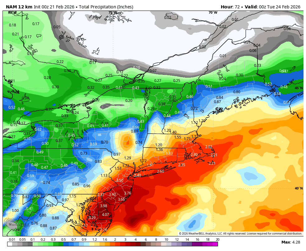
It looks like primary wintry threat in the advised area is going to be some elevated freezing rain accrual and perhaps a bit of sleet, as some low level CAD takes a bit of a hold tonight and advects temps near freezing near the surface and 925mb from the NE. Flood watches here tonight, something I haven’t seen in a hot minute. This first batch of rain has already delivered over a half inch here in the last two hours or so. Think the main thing is ice jam potential but looking at the flash flood guidance it is actually quite low. We basically melted out completely here the last couple days, so that top layer of ground is saturated and probably not completely thawed either. Good chance for some sharp rises in the local waterways. Otherwise a much needed rainfall. -
Central PA Winter 25/26 Discussion and Obs
MAG5035 replied to MAG5035's topic in Upstate New York/Pennsylvania
This has actually been the most consistent part of forecasting this the last couple days, the inverted trough/NORLUN feature plus the general lighter snows having to do with the upper level feature dropping through. The last couple model runs have been fairly consistent across the board with delivering a light to moderate snowfall. The 0z suite is solid in C-PA, Euro included, with ensemble support for such things. What is still wildly different is the evolution of the coastal itself. 0z GFS threw down like 30” on a big part of the Delmarva, while the 0z Euro has 1-2” at best there and way offshore with the developing coastal. -
Central PA Winter 25/26 Discussion and Obs
MAG5035 replied to MAG5035's topic in Upstate New York/Pennsylvania
There’s a lot of energy pieces in the 500mb flow to sort out. It looks like the main piece is phasing in later on guidance now, firing the coastal more offshore. That deep 500mb shortwave still passes over us, so could still have some lighter snow in that scenario. One thing that I saw hints of in various intensity across the overnight op guidance is presence of an NORLUN/inverted trough type feature… something that just occurred in New England a week ago. That’d be a more localized thing, and probably something hard to nail down the exact location of. 6z GFS had the feature a good bit further west vs 0z GFS, for instance. Then there’s the 84 hr 6z NAM with the wave coming through a full 24 hours early, full disclaimer on it being the 84 hr NAM. But I certainly wouldn’t say the models have a handle on this yet. -
Central PA Winter 25/26 Discussion and Obs
MAG5035 replied to MAG5035's topic in Upstate New York/Pennsylvania
In what has been a pretty good indicator of warmer times ahead for us the last few winters, Mammoth Mountain point and click has 59-93” in the grids from now through Thursday lol. I do like the weekend timeframe if we can line something up at the proper time. There looks to be 2-3 different waves this week… Wed, Fri, and then the Sunday system that has occasionally shown up as a snowstorm. The first two waves favor rain with some potential for mix NE. -
Central PA Winter 25/26 Discussion and Obs
MAG5035 replied to MAG5035's topic in Upstate New York/Pennsylvania
We’re cooked in the low levels up thru 925mb or so, the easterly/northeasterly flow from the low going to the south is drawing sub zero 925mb air thats in place from that direction.. hence the backwards changeover. Actually a pretty decent band of precip running along the I-80 corridor from State College over to pretty much NJ, and there’s accumulating snow on the cams on I-81 and 80 near Hazelton and down I-81 as far as at least the US 209 exit north of Pine Grove.