

BlunderStorm
-
Posts
1,122 -
Joined
-
Last visited
Content Type
Profiles
Blogs
Forums
American Weather
Media Demo
Store
Gallery
Posts posted by BlunderStorm
-
-
The winter storm from February 16-18 2015 named "Octavia" was the most memorable storm for me. I never took a measurement but I would say over 14 inches of snow fell and was then followed by truly arctic cold. Temperatures I believe fell into the negative teens here and then in the following days a couple more notable winter storms followed after. As a result a snowpack lasted here into the first week of March. I'm sure almost all of you recall this but I guess because the event was less impactful as a near miss, you don't reflect on it as much. This and the 2011 Super Outbreak earlier in my childhood are what charged my interest in weather. I would kill for a repeat of this with you guys getting more out of it. I know this is unrelated to the discussion. The ENSO conditions were a nada and the sun was more active but the storm snow totals jax showed reminded me of it because it took a similar track and caused a blockbuster event.

-
 4
4
-
-
50 minutes ago, Holston_River_Rambler said:
The results of the upslope snow and rime on Max Patch:
The air was so clear! The temp was about 23 with a stout wind.
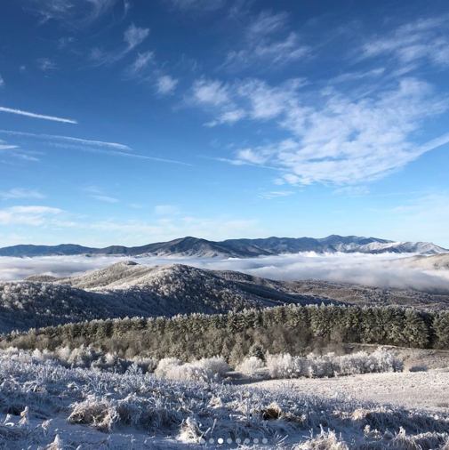
Just a teaser (wish I could upload them all here!).
Here are the rest: https://imgur.com/gallery/OUr79E1
Wow... Those pictures are absolutely breathtaking...
-
 1
1
-
-
At last after a lot of trial and error I was finally able to get at least one of the images through! I sure hope this is a preview of winter.

.thumb.jpg.b8f40db198fe831d0a25a1ab04044728.jpg)
-
6
-
-
About 0.2 inches fell barring any rogue snow showers overnight. The event was a success in my book but it leaves me hungry for something more significant. I'll send an image in the morning.
-
3
-
-
Currently 34 with rain and snow falling.
UPDATE: It has quickly fully transitioned to snow and is 32.
UPDATE 2: The ground is cold enough to support snow on the grass measurements will be taken.
-
2
-
-
27 minutes ago, Blue Ridge said:
45 at K0A9 (Elizabethton)
43 at KTRI
43 at KGCY (Greeneville)
41 at KLNP
39 at KVJI (Abingdon)
39 at KTYSIt will be after dark before token flakes are possible.
When I'm not using my weather station KJFZ is the station I use. Whatever temperature it is add two degrees and more often than not it lines up perfectly.
-
1
-
-
Radar is starting to get interesting for the NE portion of the forum area but I can't help but shake the feeling the back end of the storm is coming too early for snow. It's just 40 all the way up here so the temperature and has a ways to fall in the eastern valley. I'm hoping you guys in the Tri-Cities see some token flakes.
-
1
-
 1
1
-
-
Check out this webcam in Wytheville. You can see with every shot this morning the trees slump more and more from the ice.
-
3
-
3
-
-
It was 33 at dawn this morning. A really close call that leaves the mountain passes where I'm more concerned in the freezing rain. With the upper air temps I question the snow is Wise but it may be possible. I checked the webcam at UVA Wise and there did not seem to be snow.
-
2
-
1
-
-
The temperature bottomed out at 36 around 8. Now the temperature has risen to 39. Looks like it's going to remain above freezing.
-
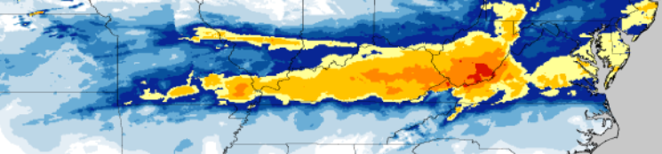
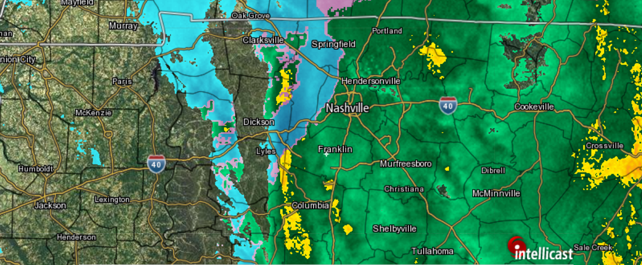
I wonder if this is actually snow west of Nashville as Intellicast is depicting.

-
45 minutes ago, zippity said:
Wonderful to see folks getting snow in November!
It's good to see less frequent posters out today! Currently where I'm situated it's 37 to start the night. I doubt any serious accretion here on the roads but the grass may very likely have a glaze. Here I'm more concerned around mountain passes about 500ft higher than here in areas like Jewell Ridge. Glancing through the modeling one more time I imagine most of us will have a window for a flurry or two after the more significant snowfall ends in west Tennessee as the upper level low slides through. After all the cold, wet, and grey days we've had I'm open to a break in the active weather for a sunny seasonable Thanksgiving. By the last week of November I'll be ready for some more action though.
-
3
-
1
-
-
49 minutes ago, AMZ8990 said:
Starting to see some sleet accumulate in the grass, I had to make the pic smaller so I could upload it so I’m sorry if you all have to squint to see it! lol

Status report? A light drizzle has started over here. Don't know the exact temp but it's probably 40ish. EDIT: Just before I posted!

-
10 minutes ago, AMZ8990 said:
Stay safe buddy, I wouldn’t want to drive on icy roads up in your neck of the woods that’s for sure. I’m rooting for you to score with the snow. Should be an interesting day as this all develops.
The roads around here can get especially treacherous during inclement weather. Still being in high school I'm not exactly the best driver in the world and my experience driving in snow is limited to once or twice last winter. Needless to say I shouldn't and won't be out on the road and honestly nobody else should tonight up this way. I'm hoping my school calls a 2 hour delay tomorrow. The last thing we need is a bus skidding on an ice rink. I wish you the same in terms of snow and I know it would be more special for you. Anytime I see snow on the radar down in dixie I smile.
-
2
-
1
-
-
2 hours ago, Holston_River_Rambler said:
A little concerned about ice for Blunderstorm this morning and parts of SW VA. Looks like the cold air has done quite a good job filtering into some parts of SW VA. Some places are even colder than areas east of the Blue Ridge I'd expect to be colder during normal cold air damming. If the Wundergorund maps can be believed, it's 28 near Wise, and 33 at Nickelsville, and I even saw a 35 near Mt. Carmel, TN. The 3k NAM, RGEM, and Hi Res RGEM want to keep cold air draining in overnight and pushes the freezing rain toward the TN border. All this may be mitigated by the fact that it's November, the ground is relatively warm, and most of the precip. will start to move in after a full day of insolation. Everything about this set up is anomalous for Nov., so I guess we wait and see.
In terms of snow, even though the model trends John mentioned are apparent for western forum areas (don't want to sound discouraging and as John mentioned still think it's a wait and see thing with the wobbles), there is also a trend for the upper low to hit a wall in its NE movement near Paducah, KY and swing much more easterly and cruise across the TN/KY line. Curious to see if the illusive Rain to Snow can still sneak in, if not for me, at least for northern plateau, southern KY, and TRI.
Some good looking bands developing with occasional 30 dbz reflectivity in S. Arkansas this morning. Let's see where they go.
I'm now under a Winter Weather Advisory and live just a few miles from the border of Tazewell county currently under a winter storm warning. The RDPS/RGEM is painting an icy picture up here and some of the others aren't far behind. If I do get a glaze of Ice I'll be sure to send pictures but I'm not rooting for it. What I am hoping for is maybe...just maybe a solid hour of light snowfall on the back end of this storm. I'm not very patient with winter.
-
4
-
-
RGEM and ECMWF fwtw aren't budging with the freezing rain way up in SWVA. All other models go with the typical Tazewell-Marion river valley boundary with the freezing rain. Knowing my micro-climate better than a weather model though the chances are it's going be 34 in a downpour all night thankfully. Anyway I'll shut up... back to the main event of the forum out west!
")
-
1
-
-
3 hours ago, AMZ8990 said:
I’ll take colder and snowier all day long, if it comes to pass then I’ll have to give The euro some major Props since it was the first model to really start showing the cold/snow on my side of the state. I’m Definitely intrigued and am keeping an eye on it. We’re only 48 hours or less from this event so today’s runs will hopefully give us a better depiction of what will happen. High is only 37 today too so it’s gonna be a chilly day!
It's always good news to have the euro on your side for an event. A few days ago when the models were teasing the possibility of snow over here the euro never really supported it at least as I recall. I hope yall get something out of this.
7 minutes ago, Carvers Gap said:I would say the usual spots are at risk...places like Marion and eastward. I think elevation "might" actually (famous last words) help you. Also, I am not sure that I can ever remember an ice storm in this area during November....but never say never. Give it a look at 12z, if you all are at risk...we can definitely make that part of the conversation. I noticed the far northwest corner of NC was at risk as well. We'll need to pay particular attention to where the high(to the north) is. If it trends west of the Apps...sometimes cold can run into SW VA. If it is east of the Apps, we get downslope and it stays warm enough. I could easily be wrong...but wanted to make sure to discuss your area a bit. All of SW VA gets ignored far too often in many aspects whether it be sports, politics, weather, etc.
I love snow and I can enjoy the novelty of sleet but freezing rain is where I draw the line and am typically not in favor of it. It's wet, yet at the same time freezing ,and all surfaces turn into an ice skating rink. Weather wise it would be interesting though. I have my eye on the back end of the event where cold air wraps around and I have a chance for snow the next evening/night. If the upper layers could just get a little colder maybe it could be sleet or perhaps snow early Thursday morning but I highly doubt it. I did notice the higher pressure north of here on the euro but the center of high pressure is still over New England.
-
1
-
1
-
-
After seeing tonight's run of the euro I am concerned about the possibility of an ice storm in SWVA Wednesday night into Thursday morning. I'm too tired to really delve into it tonight but this may be worth discussion for tomorrow.
-
1
-
-
17 hours ago, Carvers Gap said:
Awesome. I forgot about downsloping - that ain't no joke! It is the great eraser. To add, I think @Blue Ridge and a couple of other posters are in the area as well. We also have several other posters from the region who might want to chime-in. But to echo tnwxnut, this is a great time in Johnson City's history in terms of city growth. The entire TRI area is in the process of trying to sort-out how much of a regional entity that it wants to be vs three defined cities. For example, we just had a major healthcare merger which is transforming care across the region. The TRI metro area has a fairly large population, and I often think folks are surprised how many people are in NE TN.
I would imagine given enough time the three cities would kind of meld together along with the many towns in the general vicinity of them from Abingdon to Gate City to Jonesborough. Of course with the current rate of development especially further north in Virginia being basically stagnant that is far off.
-
2
-
-
I had forgot to check yesterday but looking back on my records it reported the temperature at a frigid 16 Sunday morning!
-
1
-
-
Tonight marks the first flurries of the season. Currently 35F with no accumulation on any surfaces. So it looks like I'll record my first trace!
EDIT: Wow, I reached 500 posts!
![IMG_1008-min[1].JPG](https://www.americanwx.com/bb/uploads/monthly_2018_11/1786802203_IMG_1008-min1.thumb.JPG.c6b60cf31efa8241a7c39ef35b83519b.JPG)
-
4
-
-
1 hour ago, John1122 said:
While verbatim the outcome changed some on the 0z GFS vs the 12z today. The track/intensity/hp to the northwest stayed virtually the same on the GFS. Gonna be borderline for a decent miller A storm or just a perfect track wasted if the GFS comes to pass. If it were December the 15th we'd be rocking with that path statewide or close to it.
It's looking like an uphill battle with the "supposed" changeover being during mid-day in a November for the eastern valley. We just need the cold air in place a little quicker and I guess that would imply either a better positioned/stronger high pressure west of us or the system arriving a little later. If we had the cold 6 hours earlier at dawn on Tuesday I would feel a lot better with what the GFS is showing. As for other models for the 0z ICON the cold air simply never reaches our sub-forum. The 0z Canadian presents a similar scenario to the most recent GFS except with maybe more potential for snow in west Tennessee. The 0z FV3 is pretty much in line the GFS and Canadian as well. Will see what the euro brings to the table but I have a sinking feeling it's going to be like the ICON with how it ran 12z as an Apps runner.
-
1
-
-
22 minutes ago, Windspeed said:
12z ECMWF did crush SWVA and the I-81/I-77 interchange corridor. Pretty much the entire extreme northeast TN Valley Watershed above 2,000 ft, and all points North and East from Abingdon and above 2000 ft had great returns.

Yeah I'd be crushed. With how heavy and wet that snow would be I could see power being knocked out for a lot of folks up this way.
-
The latest Euro and GFS have peaked my curiosity. In the eastern Tennessee Valley I have my eye on the possibility of the storm around Tuesday taking a Miller A track. If this were to occur and we could somehow get the cold air in place we might have a shot. Also, hope you have a good vacation John!
-
1
-
.jpg.afefb126e8b5940180a5d5c476c11907.jpg)
![IMG_1008-min[1].JPG](https://www.americanwx.com/bb/uploads/monthly_2018_11/1098927381_IMG_1008-min1.JPG.6b1196dda4c5ffdc748ae4bd0f830893.JPG)
Fall Banter 2018
in Tennessee Valley
Posted
I hope all of yall are having a wonderful Thanksgiving!