STILL N OF PIKE
-
Posts
14,848 -
Joined
-
Last visited
Content Type
Profiles
Blogs
Forums
American Weather
Media Demo
Store
Gallery
Everything posted by STILL N OF PIKE
-
Ya the risk is basically Favored for SNE
-
Gotcha Makes sense the Second part is more up in the air for where it focuses. We need the south side of a ULL to bless us
-
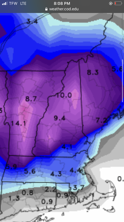
Thanks much neater than my post the first batch Thur nite got Boston and even areas S and SW with almost a SWFE look to accums
-
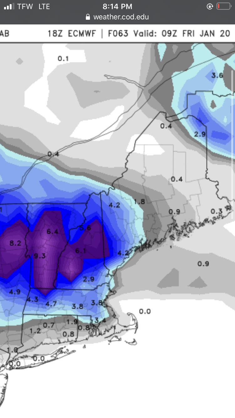
Actually most of the snow around the pike on The 18z euro image is Thur overnite this run It looks like it adds a 1/4-1/2” near pike overnite Friday and keeps the ull stuff further north on that run this thru 5am Friday

-
Somehow 18z euro gives Attleboro more snow than tolland with the overnite stuff late Thursday . Odd. But either way snow is further south on 18z euro for what that’s worth . Then the ULL stuff stays in CNE /NNE this map is thru Friday 21z
-
Hanging by a thread , tolland needs Friday
-
Ya that system seems to have the wide goal posts that you’ve alluded to . If that’s cuts thru NY then it will be a sad day filled with One reindeer sweater wearing weenie at Sprucepeak. We have never had a powder freak melt that I can recall .
-
Mike gets a little antsy , he used to drink 12 diet cokes a day and I think it left him with some restlessness
-
Nice skiing
-
Ya I see the “lift” at the upper levels on the south side of the vort. Let’s see if that stays around
-
Only issue is the ULL goes thru central New England to southern Canada , but we can call that south of Long Island if we are confused Looks like the best lift is on the south side of it Thou
-
Light Steady rain 41f bleh
-
True , that would be a kick to the balls
-
Looks like Wolf Creek , Co will put up a 50” spot from this 3 day system by am as well. Pretty wild how Mammoth to Alta has been locked in but the resorts 150 miles south / SE missed most of the moisture till lately
-
Florida/Savoy to Rowe FTW
-
Up and in that run
-
Looked great for Cranmore ..add a few more days to your trip lol it was mostly rain south of route 2 mass , except the day 9-10 system which was a bomb in la la ish land
-
Well..if it sets up SE then that’s a good thing the majority of the time ..for methuen getting the snow
-
Correct , I can count the times a met has said looks “pretty good from Ray to xyz” and that has like a 25% success rate . Nobody has really said that specifically .. some have said NH/Ma border north looks decent but not sure if they mean inland w some elevation Sunapee looks to get smacked and considering they had maybe 1” in the woods Sunday ..they could use it .
-
In your life experiences is 4.5 and 7” a big difference
-
Absolutely , seems we will now see a nice gradient pattern over New England . With big totals where it’s snow and big melts if it’s predominantly rain in others .
-
I’m gonna miss the endless stream of day 10 posts by April
-
Just crushed in the mountains outside wachusett
-
Euro likes methuen North
-
Euro gives love to methuen early on