
CNY-WXFREAK
-
Posts
3,872 -
Joined
-
Last visited
Content Type
Profiles
Blogs
Forums
American Weather
Media Demo
Store
Gallery
Posts posted by CNY-WXFREAK
-
-
We may actually see a few flakes from that death band to my North, lol, as I'm tracking one last AF due to arrive tomorrow evening into Friday where we may pick up 2-3" but I definitely don't believe any model that has us getting more than 4" South of say, Central Square, as thats about where the band falls off the Lake
-
36-50" is just hilarious, lol, a season of snowfall in one event, wow!
-
Real glad WNY is finally getting their share of intense mid-Winter conditions, awesome guys, Enjoy

 !!!
!!!
-
 1
1
-
-
We barely get to 6" for the next 16 days on the Euro EPS, lol! That brings us to the 14th of Feb then a month of ups and downs through March and then Spring's around the corner as this Winter season needs to be put to rest!
-
Like I posted earlier, we will most likely end the season below normal here in the Immediate CNY area, actually just the Syracuse area is doing bad, as places to our South West North and East have done better this yr and KROC will most likely beat us as well this yr but there's still time to salvage some, but I don't think much will change as the storm track is locked in and mainly to our West.
-
23 minutes ago, TugHillMatt said:
How did you do today? Looked like much of the snow missed you and freak's homes today @wolfie09
i'm up to a whopping 2", lol, but its still coming down nicely as I just posted but this usually occurs when the system is pretty much coming to a close, so a horrific bust for here, but it was fully expected as nothing, and I mean nothing has come together this yr for us but this happens every so often like 11-12', which was another bad bad winter for snow but they do happen, thank God not too often though!
-
1
-
-
Must be a last hurrah of mod-heavy snow here in Fulton, so everyone else enjoy the next 2 days as its going to be an incredible event for the usual suspects!
-
i think the Rgem totals are way to low
-
Those NWS maps are a complete joke! RGEM looks the most reasonable, yeah its not the blockbuster totals, actually their quite paltry compared to some of the other meso's so...... None of the globals see much in the way of LE off of either lake so that's weird to me as even the Euro is low with QPF and it pegged the last event over KWRT so we'll see and I hope you guys out west are right but I'm with Westerly that no one sees over 15" out of this.
But I hope everyone gets crushed!
-
Wasn't expecting much in the way of accumulations overnight but its begun to snow. Mostly a light, pixie dust type snow, again, as I'm surprised its even precipitating, as dew points are in the single digits and temps in the upper teens, interesting.
-
This is so appropriate for this yr, lol, if something is supposed to go wrong it will!
830 PM Update...
Latest incoming model trends confirm the adjustments that were
made earlier; lowering expected snow amounts along and
especially west of I-81 while maintaining the relatively higher
amounts to the east. It has become clear that the initial round
of snow will be on the light side; as in for the majority of the
area only about an inch or less by dawn except for more like
2-3 inches north of the NY Thruway such as where topographical
lift will occur in northern Oneida County.
Wouldn't expect anything different this yr.
This is what we need big time otherwise we literally end up with 2' totals
There is some suggestion that a brief deformation band
could hang for a time around Cayuga-Cortland-Onondaga for maybe
a bonus couple late-day inches but models differ considerably.
-
I don't think I've ever seen so many solutions for one event such as this one. Every model out there has a different solution, weird as there is absolutely no agreement amongst models. It'll be interesting to see which model comes closest to actual accumulations.
-
Can we get an obs report out of Wayne County please someone?
-
Thats was a good one Tim, Back door cold front, lol!
-
Just now, Syrmax said:
Good point, was thinking that might be the case. It is dry. I'll go with 1/2 -3/4" by dawn here.
Thats being generous bro as I'm going with zip for tonight and as the front approaches tomorrow sn may get heavier and steadier for a time, but will be over in no time. almost like a CF picking up a band and taking it with it.
-
We'll be in a virga storm real quick and its gonna need to precipitate quite a bit before saturation as we're sitting at 18F/1F, lots of wasted precip for sure!
-
It was almost wide open the last few days, WOW!
-
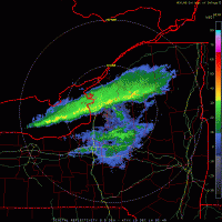
Just now, southbuffalowx said:
Ice cover as of this afternoon...
If thats real it'll be frozen over by the weekend, lol!
-
I have a feeling there's gonna be quite a few members who are disappointed for just getting 18" when they were forecasted to get 40, lol!
-
Yeah, and it needs to slow down, or whatevers forming needs to bomb, but neither will happen, lol!!
-
 1
1
-
-
Just now, 96blizz said:
Yeah. I’m in Skaneateles and think 3” is a stretch.
This is the timeframe we need to produce.

Thars a 15 minute squall line with the front, we'll be lucky to see 1-2" from that, but maybe it stalls, lol!
-
Its truly possible that we don;t see the low end, lol, nevermind 9", lol!
-
1
-
-
I do however think its gonna snow, and snow hard even here, for a time, late tomorrow night through Wednesday morning, but the question is how far west the front slows down as a SLP gets going along it so we'll see as I think its more of a timing issue than anything.
-
Man I hope it does but if anyone wants action on the over or under, I'm taking bets since sports betting is legal now, or is it,


Upstate/Eastern New York
in Upstate New York/Pennsylvania
Posted
Hey CNYwx, you have a Ford F250 or something that size, o r a nice Subaru, lol, to head up North in? Heck we're about 45 minutes from what can be one of the biggest events in somer time WOOWzers! I'm ready any time you like. You too Bri, I just don't have the wheels or else I'd go for sure!