
CNY-WXFREAK
-
Posts
3,872 -
Joined
-
Last visited
Content Type
Profiles
Blogs
Forums
American Weather
Media Demo
Store
Gallery
Posts posted by CNY-WXFREAK
-
-
There's no model in the world that can predict a LES event from 4 days away!
-
Its now a NW-WNW flow, lol, seriously?
-
32 minutes ago, wolfie09 said:
Euro at 6z still with the West-WSW flow.
.thumb.png.24987067f65e0abec2e6cd727c4e03ec.png)
Yeah, but 6-8" isn't a real respectable LE event though, lol!
-
Yeah I don't know what happened but the LES event vanished from all guidance, lol, except EURO and I wouldn't depend on that for LES but ya never know! WOW, WTF cant get a westerly flow event for shit, crazy! I think Westerly needs to change his screen name fir sure!
-
 1
1
-
-
Actually, its a mixture of snow and ggrauple??
-
Sorry to say this but we're getting a shit load of rain in the small amount of time it does rain, so that sucks and its just funny how it happens to precipitate the hardest when its warmest, understandable but annoying!
-
Rochester's already up to 31F so that already means we're doomed, lol, with lots of liq precip rather than zr! The pack we have can suck up at least an 1" of liq and still be ok so thats probably the only silver lining in this debacle. From Arctic air then in 1 day up to the low 40's, lol!
-
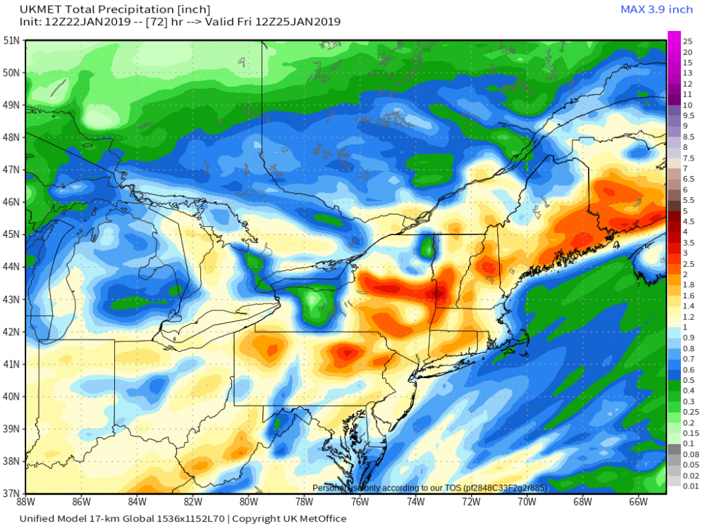
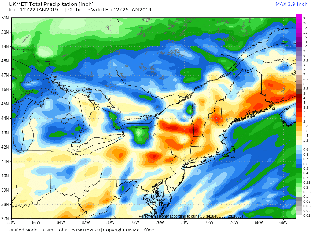
This is quite a bit of precip through 12Z Fri, wow, and only like .4-.7 goes to rn and its obviously the UKMET so.....
-
Really like this look with an inverted trough over NCNY into CNY for a time between Thurs-Fre, nice but does it come to fruition?
-
Pretty much has nothing going against it!
-
Could be a super significant event for sure!
-
Confidence is off the charts that temperatures will average below
normal during this period...as a highly amplified pattern will be in
place across the continent. A very staunch ridge centered off the
west coast will define a +PNA pattern that will be coupled with a
persistent ridge over Greenland...a CLASSIC cold weather pattern.
The pair of ridges will lock an expansive closed low over eastern
Canada...part of which will include the polar vortex. This notorious
feature is forecast to push at least 500 miles further south than
usual...possibly settling between Lake Superior and James Bay. The
coldest air in the northern hemisphere will not only be on this side
of the pole...but because of this pattern it could conceivably be on
THIS side of James Bay! This pool of glacial air will also be
supported by a persistent cross polar flow...which will not only
prevent the airmass from modifying...but will also serve to keep it
`charged`.
-
1
-
-
LES all over this 10 day snowfall map!
.thumb.png.930257f9cf6d72260263b4619068230c.png)
-
1
-
-
This has CHASE written all over it for sure!
-
25 minutes ago, mississaugasnow said:
If you dont mind me asking, whats the fetch off Georgian Bay looking like? I'm going to be up in the Muskoka/Parry Sound area this weekend and WSW wind normally crushes them up there as well (even when Georgian Bay is slightly covered with ice)
Its looking like GB will be getting seeded by both Lk Superior and Huron for quite some time it looks like so I'd imagine its a pretty good bet that someone sees a heafty amount!
-
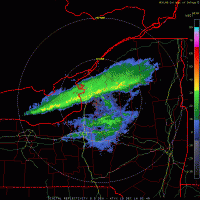
Alls I know is, someone up in the Tug this weekend is getting feet of snow with a band extending some 50-60 miles, out over the water, its gonna be sick! I bet driving North this weekend up 81 is gonna be a sight as you get closer and closer to the billowing clouds ( almost pillow like) ahead as they look like a mid-summers thunderstorm only to find blinding blizzard conditions with rates approaching 2-3 and sometimes 4"/hr, with 25-35mph winds blowing it and drifting it all over the place! This event as all parameters, for a serious blockbuster event!
-
2
-
-
It goes above freezing on the Nam at the surface for 9hrs at the most, and on the Euro, its 27hrs, lol, whats a day difference, lol!
-
This weekends event will be the first chase worthy event of the season I think for the Tug so get ready cause its coming Matt!
-
If you have a Ski trip this weekend up in the Tug then I'd be jumping for joy as its gonna be a winters paradise up there this weekend starting tomorrow actually cause I don't see anywhere near as much rn as the Euro is seeing .
-
1
-
-
I think Matt gets affected worse than Carol this time around so we'll see!
-
URGENT - WINTER WEATHER MESSAGE
National Weather Service Buffalo NY
110 PM EST Tue Jan 22 2019

NYZ006>008-230215-
/O.NEW.KBUF.WW.Y.0007.190123T1200Z-190123T2300Z/
Oswego-Jefferson-Lewis-
Including the cities of Oswego, Watertown, and Lowville
110 PM EST Tue Jan 22 2019

...WINTER WEATHER ADVISORY IN EFFECT FROM 7 AM TO 6 PM EST
WEDNESDAY...

* WHAT...Snow, sleet and freezing rain expected. Total snow
  accumulations of up to 2 inches and ice accumulations of up to
  one tenth of an inch expected. Winds gusting as high as 35 mph.

* WHERE...The Eastern Lake Ontario Region.

* WHEN...From 7 AM to 6 PM EST Wednesday.

* ADDITIONAL DETAILS...Plan on slippery road conditions. The
  hazardous conditions could impact the morning or evening
  commute.

PRECAUTIONARY/PREPAREDNESS ACTIONS...

Periods of snow, sleet or freezing rain will result in slippery
roads and limited visibilities. Slow down and use caution while
driving.

Submit snow and ice reports through our website or social media.
A significant lake effect snow event is looking more possible from later Thursday night into Saturday. If guidance remains consistent... several feet of snow could accumulate in the vicinity of the Tug Hill. -
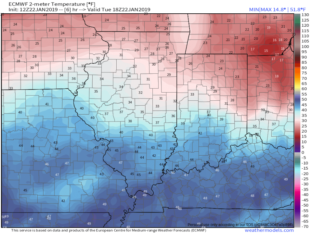
It appears to me that the Euro is way off wrt it temps as they as way too warm in some areas of the Mid-West and OH valley, the airmass which is coming our way the next 24 hrs or so. I can see being off by a couple degrees but in some areas its off by 7-8F!! i'm going with the NAM as far as temps go as the Nam has more mixing as opposed to the Euro which has quite a bit of rn bout ,75" worth.
-
Just now, mississaugasnow said:
I guess all depends on what you want. I'm more in the winter activity (outdoor hockey, snowmobiling) and I like sustained snow cover. Which is tough to get this far south, but to have a rainstorm only 3 days after the GTA first snowstorm is pretty bad haha. This winter has been a major joke, mostly due to the hype it received all fall about big storms and sustained cold. Kind of like following a sports team that gets hyped up but falls flat, stings a bit more compared to a team you knew wasn't going to do much.
Yeah I agree but I think we need to let this upcoming pattern percolate a bit before saying it didn't deliver, thats all Im really saying. I think the SSW ( which did propagate into the troposphere but theres a lag so...) and the indices look promising for once so we'll see what happens if this Winter doesn't deliver, there's always next yr and thats another reason long range forecasts are a complete and utter joke!
-
Quite a dependency wrt temp profiles for the week between the Euro and the NAM and I'm more inclined to go with the Nam for temps as it was the first OI believe to show that the cold wasn't going to budge with the last event so we'll see what happens.
.png.86a0b95c6256f4ead6f58e6cf056d1bd.png)

.png.d9ae74bb74cea223040219e5acb29e83.png)

Upstate/Eastern New York
in Upstate New York/Pennsylvania
Posted
It is but I think they all suck!