
CNY-WXFREAK
-
Posts
3,872 -
Joined
-
Last visited
Content Type
Profiles
Blogs
Forums
American Weather
Media Demo
Store
Gallery
Posts posted by CNY-WXFREAK
-
-
Most, if not all of this is rn, except perhaps 3/10 of it as a mix, so this sucks but it'll create a nice cement block, for a base!
.thumb.png.959a93290ad12db74e4d13150fe964f4.png)
-
4 minutes ago, wolfie09 said:
Euro has been pretty consistent with this follow up wave, dumping few/several inches of snow after the front moves through..


I hate post frontal action so we'll see if it pans out as most other guidance really isn't on board and being only 2 days out, you'd think the models would be form this far out, No? Anyway, I hope we see something this week down here but its looking bleak, but thats ok as the Tug hasn't seen much action of note, so it would be nice to see then get seriously clobbered!

-
 1
1
-
-
38 minutes ago, BuffaloWeather said:
I thought pattern looked great personally. Looks very active. Especially the northern jet. I’ll pass on the extreme cold though.
It is bro, its a great pattern and I don't know what some are looking at?
-
Love to see everyone buried!
-
Short lived event from what I've read unless KBUF is dead wrong?? I can see the Tug getting it big but I don't know about KBUF but I hope so!!
-
Should I say my call was right of definitely going over 2' from Saturday through Monday? It really doesn't matter as it was an incredible event and its still snowing with the sun out, lol!
-
14 minutes ago, vortmax said:
Exactly. I knew locations were pushing 2'+. Nice to see it verified.
That's not just from the LE event? Thats all the snow we'we gotten since Saturday??
-
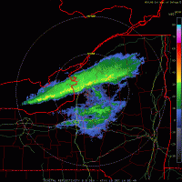
Um who's not getting over 2', lol, that was a lock but I'm adding the LE to the Synoptic cause as far as I'm concerned the event ends when the snow stops and it hasn't stopped yet, as it still snowing. I'm going out in a moment to get the cars cleaned and what not so I will measure but I know I'm well over 18" easy! Thats awesome for the KROC crew as they were due so congrats to all in Monroe and Wayne as well as Oswego as I think we were the biggest winners of this event so heres to the LE area getting walloped this weekend including the Tug!
-
1
-
-
I know its a 84hr NAM but this looks great for the TUG wow and it also has a nice convergent band so Matt, you may finally get your wish come Fri-Sat but you also may be buried alive come Sunday, lol!

the only bad thing which always is, snow growth, but with LE its usually better just cause, lol!
-
1
-
-
Euro has all kinds of thermal issues but like you said perhaps its the most believable but as always we'll see!
-
Rgem is a bit warmer in the mid-West but it only goes out to 48hr 06Z Wed
.thumb.png.4e97ed9665efebcb093cd88a4fef6705.png)
-
06Z there were hugs discrepancies between the 06Z EURO and 06Z NAM also gotta check the RRGEM
.png.2087a0a66e227f7f5e01aacf5c2b4376.png)
.thumb.png.1acbfc210aa23387a50ea7886beee5ac.png)
I have a pretty good feeling we stay all frozen but like Wolfie said, the ice threat seems the biggest right now as it'll be tough to dislodge such a dense airmass at the surface as this one is!
-
The one thing I also notice during these events, once they pass and the Synoptic moisture gets stripped away, ids the Sun usually shines through the low thin clouds but with the SNG being so close to the ground, almost any moisture trapped underneath the inversion, will fall as pixie dust snow as this happens quite often with a Super Arctic air mass like the one over us now!
I also notice all the models, excluding the NAM, as thats the furthest South but still not enough, as they are trying to drive a low pressure into all this snow cover over NYS with a retreating Arctic HP and its not like its a stale air mass, cause its definitely not, so my guess is that this short lived system for Wed rides along the baroclinic zone where the deepest snow-cover lies but I may be wrong but Ive seen it too many times so we'll see. With each subsequent run, the models are ticking South
-
33 minutes ago, wolfie09 said:
Euro still has a "favorable" west-wsw flow for Friday/Saturday.. Doesn't look like it would last long as we have several northern stream disturbances riding through the flow..
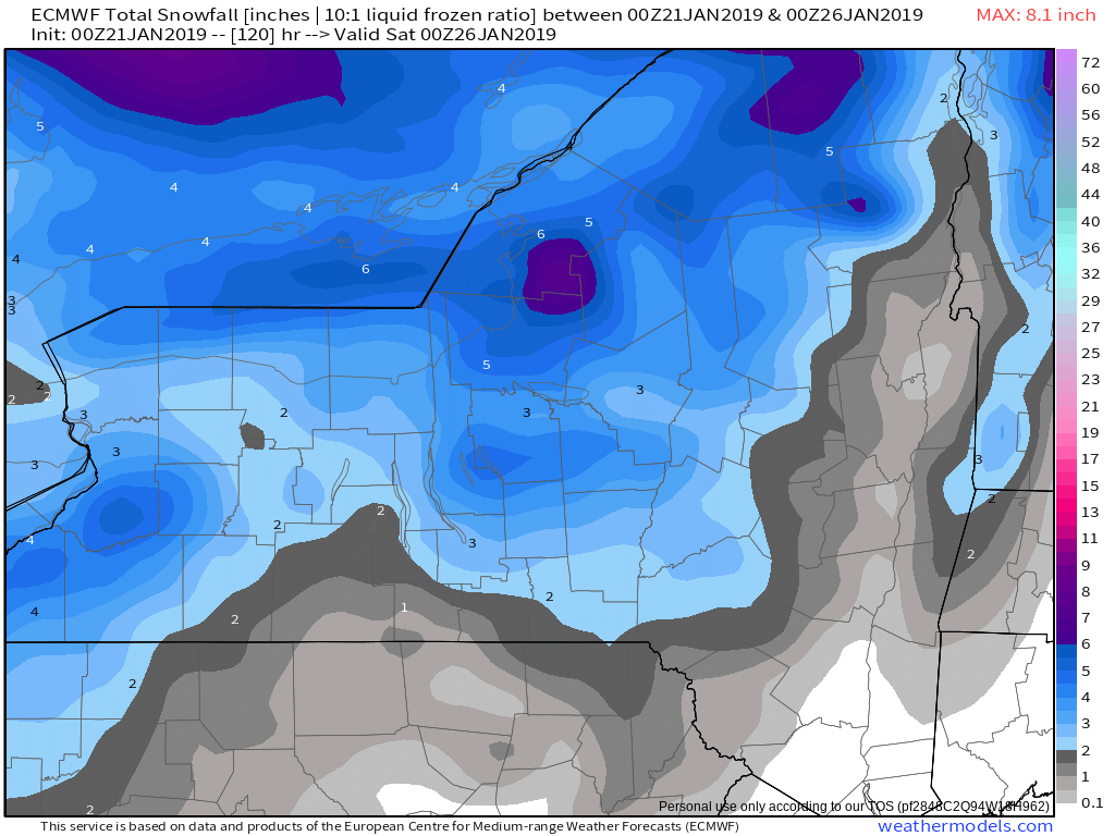
Late Thursday night and Friday a strong mid level trough and
associated surface low/cold front will cross the region, marking the
leading edge of the return to much colder temperatures. This system
will bring a chance of snow showers areawide, with potential for
lake enhancement east of the lakes.

The cold becomes well established by the weekend. Model guidance
begins to diverge with the handling of clipper shortwaves moving
through the mean longwave trough, but in a general sense one or two
weak systems will continue to support light snow chances through the
weekend. There may also be lake effect potential next weekend,
although given the model differences with the handling of the
clipper systems there is a good deal of uncertainty with respect to
placement and strength.
.thumb.png.18f6cce5474f314d849c21af4e83ee42.png)
This could easily become a WNW flow event too but most likely a Tug Hill event, then as the system moves through winds veer and the band drops through and heads WNW so we'll see what happens.
-
Whats the deal, shouldn't we be posting potential maps and what not for the future in the other thread?
-
1
-
-
Just now, SouthBuffaloSteve said:
Yes Please!!!

.I agree, especially the Tug as well!
-
My Davis Wx station took a beating as its not recording any data but wind, lol as the anemometer's been overworked these past couple days. Ill probably have to reset her but shes old too, about 10 yrs but the first wireless one that was avail back then.
The one thing I also notice during these events, once they pass and the Synoptic moisture gets stripped away, ids the Sun usually shines through the low thin clouds but with the SNG being so close to the ground, almost any moisture trapped underneath the inversion, will fall as pixie dust snow as this happens quite often with a Super Arctic air mass like the one over us now!
I also notice all the models, excluding the NAM, as thats the furthest South but still not enough, as they are trying to drive a low pressure into all this snow cover over NYS with a retreating Arctic HP and its not like its a stale air mass, cause its definitely not, so my guess is that this short lived system for Wed rides along the baroclinic zone where the deepest snow-cover lies but I may be wrong but Ive seen it too many times so we'll see. With each subsequent run, the models are ticking South
-
AS NIck said, OSUmet said the SSW was effective so I'd imagine its still propagating down to the troposphere so I'd expect high latitude blocking real soon but until the Gov't shutdown end's we can't check, but I think the Australian Weather Dept has some in depth MJO and Teleconnection so I'll be checking on it that today so ill let you all know if I find it.
-
Pretty much the only area that's guaranteed to see substantial snowfall are the higher elevations and especially the TUG but this for the next 5 days so who knows where we go from there. The pattern is still evolving and hasn't locked in yet but it should be but until then the transition will be one with many chances of either synoptic or LE so ill take it, except for the 24 hrs from 18Z Wed-18Z Thurs, other than that I think we're good!
-
CMC next 5 days

EURO next 5 days

5 days GFS

5 day FV3

ICON 114hr

-
I just wanna see NE and Brady lose!
-
1
-
-
I actually love Tims enthusiasm for sure as hes my type of weather enthusiast!
-
1
-
-
Just now, TugHillMatt said:
Hey, you never know with lake effect. They don't get it as much over there, so they're probably excited. We can get the same way in these parts during lake events.
True, hope u guys get an additional 15", lol
-
 1
1
-
-
3 minutes ago, TugHillMatt said:
I think you have something against Rochester people. Rochesterians have feelings too.

Not at all, but a foot come on, it just snowed for 28hrs straight and we got a foot, lol?
-
1
-
.png.e4f9b17fcf5b5deaf49f7873b5ed380b.png)


.png.d105152add6e7add9a12f6011e4f7e67.png)
.png.932e86ebf9405c285aeb40b1d36a0777.png)
.png.fe912ec8efba4d4e1f9fdf1c8f8f9663.png)
Upstate/Eastern New York
in Upstate New York/Pennsylvania
Posted
I wish I was KROC this week as they see the least amount of rain out of all of us, lol and they got the most snow from the event so nice one KROC!