

Brick Tamland
-
Posts
12,210 -
Joined
-
Last visited
Content Type
Profiles
Blogs
Forums
American Weather
Media Demo
Store
Gallery
Posts posted by Brick Tamland
-
-
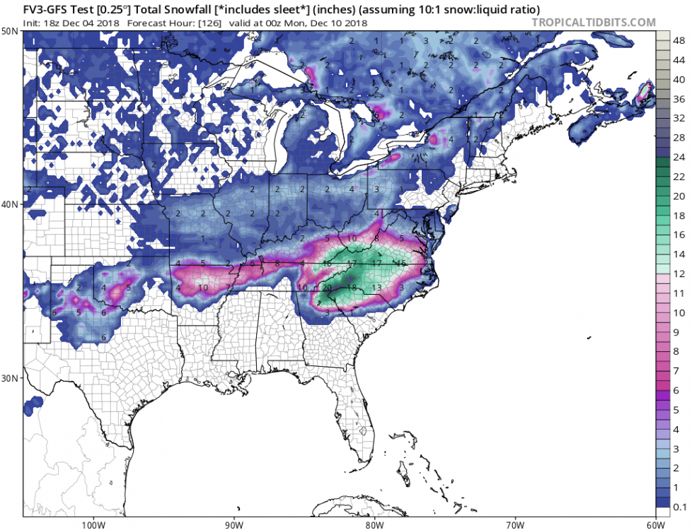
Looks like the GEFS mean went up, too. 8 to 12 across Wake.

-
 3
3
-
 1
1
-
-
3 minutes ago, Queencitywx said:
I'll take that 14.2 in durham though.
I like that pocket of 12 over my house, too.
-
Solid 5 to 10 inches across Wake, and that's with the Kuchera map.
-
Wow, looks like the GFS really upped the totals for Wake westward, and even increased totals to the east.
-
Looks like some folks are worried about the NAM being too warm for my neck of the woods.
-
4 minutes ago, Queencitywx said:

Gotta love that tight gradient between 5 and 12 inches.
-
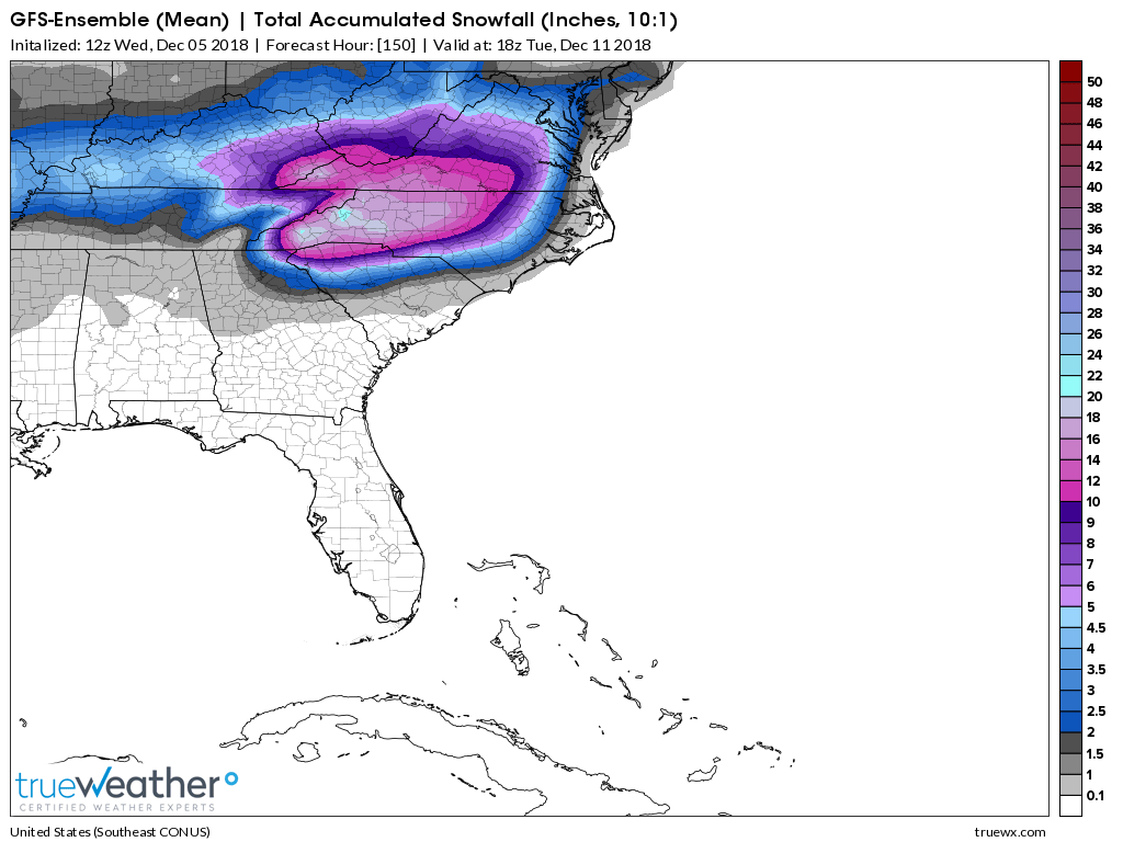
The ensembles have been pretty consistent. Mean keeps showing 3 to 6 for Wake, and the control 5 to 8. I think we get too caught up in the totals sometimes. They don't ever get the totals exactly right. The good thing is they are still showing the potential for a good storm here. Just have to see what actually happens. It's like having a good basketball team that shows potential to get a big win, but it doesn't guarantee they are going to do it.
-
3
-
-
4 minutes ago, Poimen said:
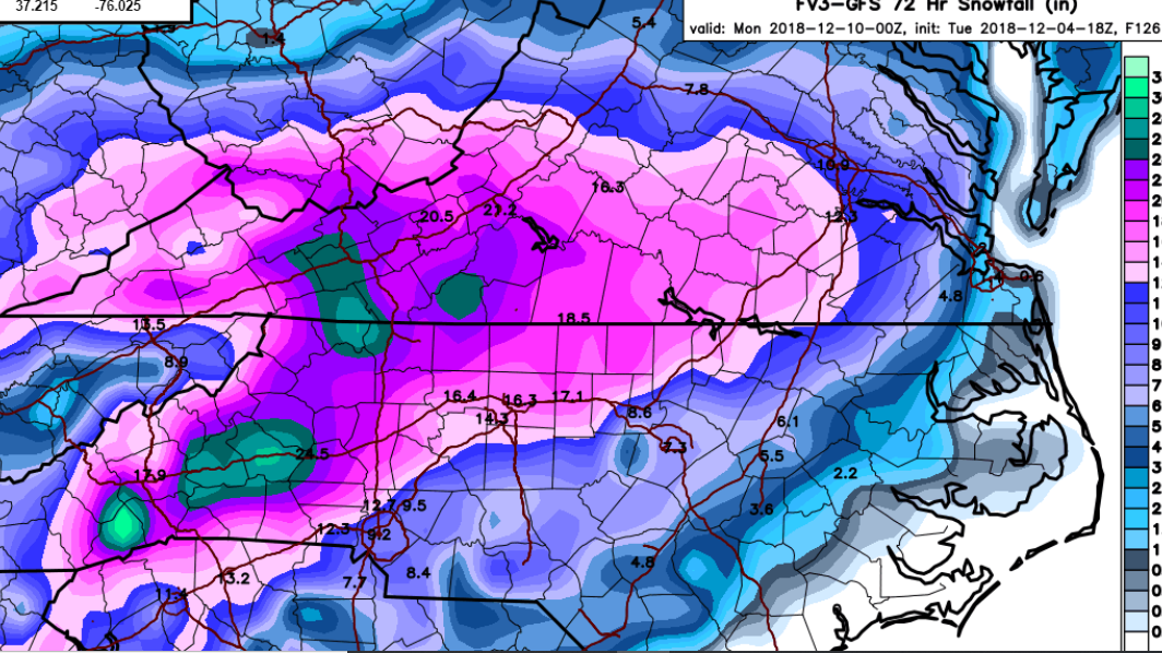
FV 3 Kuchera through 0Z Mon.

Not a foot, but I will gladly take it for the first storm so soon in December.
-
1 minute ago, WinstonSalemArlington said:
Elizabeth, I’m coming to join ya!

-
 3
3
-
-
5 minutes ago, Brick Tamland said:
I will gladly take my foot.
Seriously, even half of that would be awesome. The runs keep getting better and better.
-
1
-
-
-
If you have a shot to get your yearly snow average in one storm the first part of December, that's a big storm.
-
3
-
1
-
 1
1
-
-
1 minute ago, rduwx said:
Did you move to the western part of NC?
No, I am talking about the 3 to 6 inches most are showing for Wake.
-
We got control runs, ensembles, means all showing a big storm. Really exciting.
-
3
-
 1
1
-
1
-
-
Who is ready for Carolina Crusher 2: Snow Boogaloo?!?!
-
16
-
1
-
9
-
1
-
-
Allan Huffman has landfall still between Cape Fear and Cape Lookout, but move the inland track further south.
-
1
-
-
1 hour ago, downeastnc said:
The storm needs to come to the Euro then cause so far the track is north of all the recent Euro runs and the Euro is performing worse than most the others....so far...also the storm appears to be moving more NW than anything right now though its tough to tell with the ugly eye but i imagine the separation to the Euro runs is just getting bigger...the FV3 has been very consistent its landfall point hasnt moved more than 10-20 miles run to run for the last 6-8 runs at least.....GFS doing very well so far with track verification...surprisingly enough....still gotta take the blend of the two and thats about where the NHC has it.....the models are doing a bit of back and forth the last day and that probably will continue but overall ILM to MHX is where this likely ends up....

 49 minutes ago, downeastnc said:
The NHC uses the TVCN for their forecast track its a consensus of the models.....below is the consensus track and verification so far....this is why the NHC has its cone and ath where it does....obviously as the models move around this will too but I doubt we see them move the landfall spot more than 50 miles either way at this point.....there landfall point will shift west 10-15 miles at 11am.....

Personally, I was hoping the last Euro run was on to something with it being farther south and into SC, and Flo wouldn't track over the Triangle. But now this has pretty much crushed that hope.
-
Well, the Euro sure threw a wrench in things. Looked like we were getting a consensus focused on Wilmington to Morehead City, and then the Euro goes south into Myrtle Beach. Madness. God thing is it looks like Flo should take longer to get here, so there is more time to figure out where she will go.
-
Well, I guess coming in at Morehead City instead of Wilmington would be a little better for the Triangle folks. Also looks to be coming in 6 hours later.
-
SC is already closing schools tomorrow. I guess better safe than sorry, but that seems a bit extreme.
-
1
-
-
-
-
-
5 minutes ago, sai1b0ats said:
the update just shows a spot measurement at certain amounts of time from the update time. This isn't a prediction of how far inland it will stay hurricane. Take a look at the time labels between the updates.
I know, but they were both labeled 2 pm Friday. The last update had it as a hurricane then, and this one is back to a tropical storm. I guess they are back to thinking it will downgrade faster once it comes inland.


December 8-10, 2018 Winter Storm
in Southeastern States
Posted
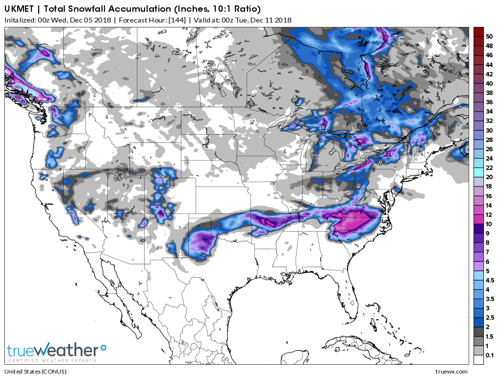
GFS, UK, and FV3 all look awesome for most of NC, especially Wake westward.