

Brick Tamland
-
Posts
12,210 -
Joined
-
Last visited
Content Type
Profiles
Blogs
Forums
American Weather
Media Demo
Store
Gallery
Posts posted by Brick Tamland
-
-
4 minutes ago, WidreMann said:
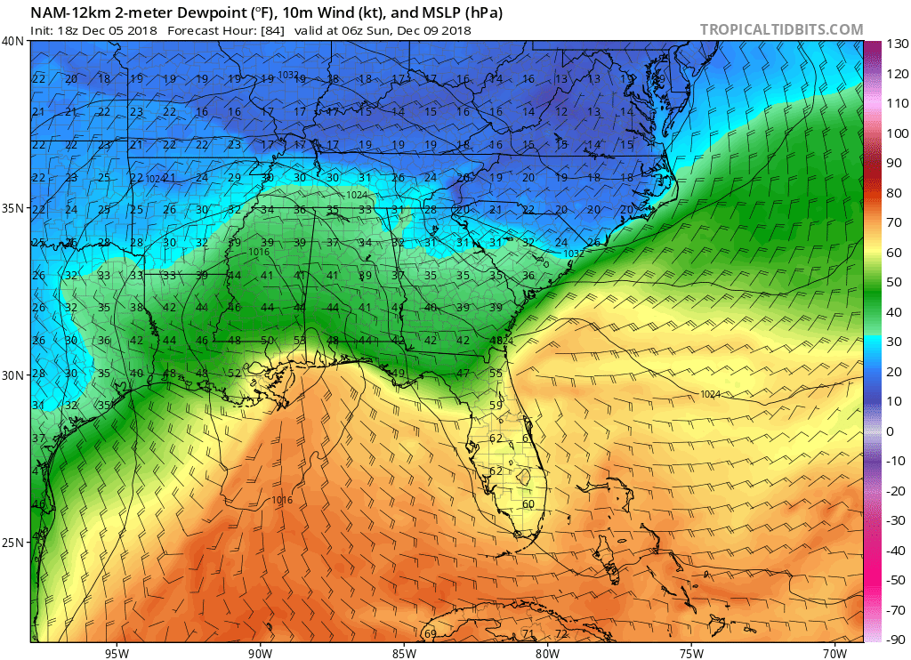
Snow line further east in NC with slightly cooler temps. Strong NEly flow at 925, easterly at 950 and weakly southerly at 700. Below freezing throughout the column at RDU.
1 minute ago, TARHEELPROGRAMMER88 said:GFS is warmer this run. Let us see if it continues, like it typically does.
So, cooler or warmer?
-
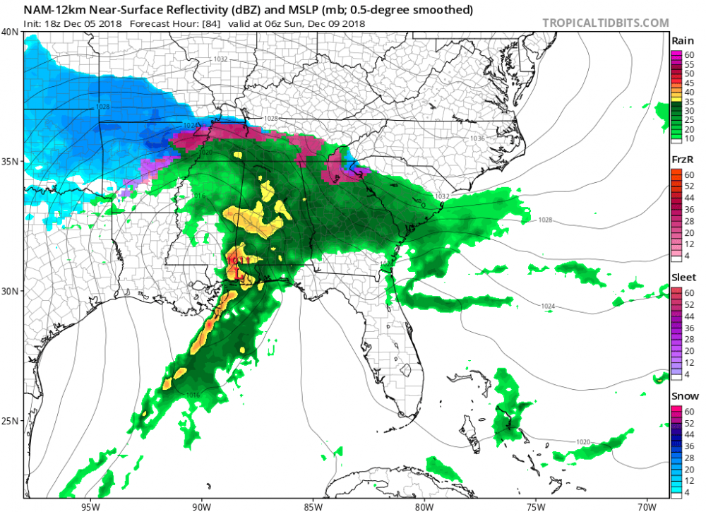
NAM really bringing in the cold air to NC.
-
 1
1
-
-
45 minutes ago, beanskip said:
Look, it’s time to be real on this storm. I know we have all become experts on hedging and caveats and flies in the ointment. But I go back the old Wright Wearher boards 20 years ago and we have never, EVER seen a storm modeled like this. Consistent, run after run depiction of a historic event. Three inches of QPF paired with a classic CAD? Yes, the features will be better sampled in a day but I really don’t think Lucy can pull away the football on something like this. Even if the QPF is cut in half it’s still a monster. Even if the CAD is overstated by 100 miles, a large area will see more than a foot.
Bottom line: anything can happen, but I had to eventually wrap my head around a Cat 4 October hurricane and I wish I had accepted the inevitable sooner.
This thing is coming.
I just don't think you can discount the consistency of the models, and how different models are showing the same thing over and over. And everything has trended colder and farther south and east with the snow all day. Yeah, I can see questioning getting a foot here, but even half of that would be amazing this early in December. I just don't see this being more rain than mostly snow and other frozen precip based on how consistent and similar the Euro, GFS, FV3, and NAM have been.
-
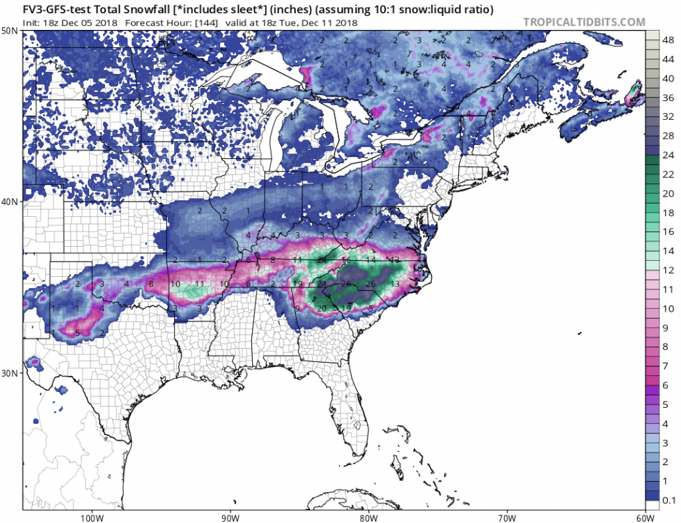
Looks like the totals increased again farther south and east on the GFS.
-
2
-
-
4 minutes ago, Cornsnow said:
The models are really going against all climatology here. It would be a super rare event if it occurs. I am still tempering my excitement. Still plenty of time for the to collapse in our faces. Hopefully we will be sampling the energy here tomorrow. Still hard for me to think an amped up storm like this will not have huge issues with WAA like always.
We also saw a hurricane do something that has never been done before with Florence.
-
 1
1
-
-
This might be more realistic.
-
1
-
 1
1
-
 1
1
-
-
I believe.
-
3
-
2
-
-
Models just keep getting better and better. Really hope the rug is not going to be pulled out from under us.
-
4
-
-
GFS before it got stuck.

-
1 minute ago, CaryWx said:
How is the sounding for RDU on the 18z? Should I ask?
Looks like almost all snow this time. Colder and farther south has been the theme today.
-
1
-
-
4 minutes ago, Shane said:
So how many models are in basic agreement now?
I think all the major ones except the ICON.
-
1 minute ago, FallsLake said:
Just had a chance to look at the 18z NAM. If the CAD and dew points are correct, this will be a major storm not just for the western/central folks but for folks into the coastal plain.
And I have heard numerous times the CAD is often stronger and harder to erode than the models show.
-
That look reminds me so much of what it looked like the evening before the Carolina Crusher in Jan 2000. I remember looking at the radar before leaving work that night and wondering why the local forecasters and RAH was not calling for much of anything here with regards to snow. I know the technology has improved since then. But now it seems like they don't believe the technology this go around.
-
2
-
-
2 minutes ago, burgertime said:
What the models are putting out is pretty wild and with such consistency. I should be up for the Euro in the morning (I'm 6 hours ahead). If the 00z suite especially the NAM and EURO hold I think it's not absurd to go all in. Still gonna be a million dollar question of where snow/sleet setup is and where ZR happens because that could be very very bad.
RAH doesn't seem like they believe what the models are showing at all.
-
Dew points look good here.

-
1
-
-
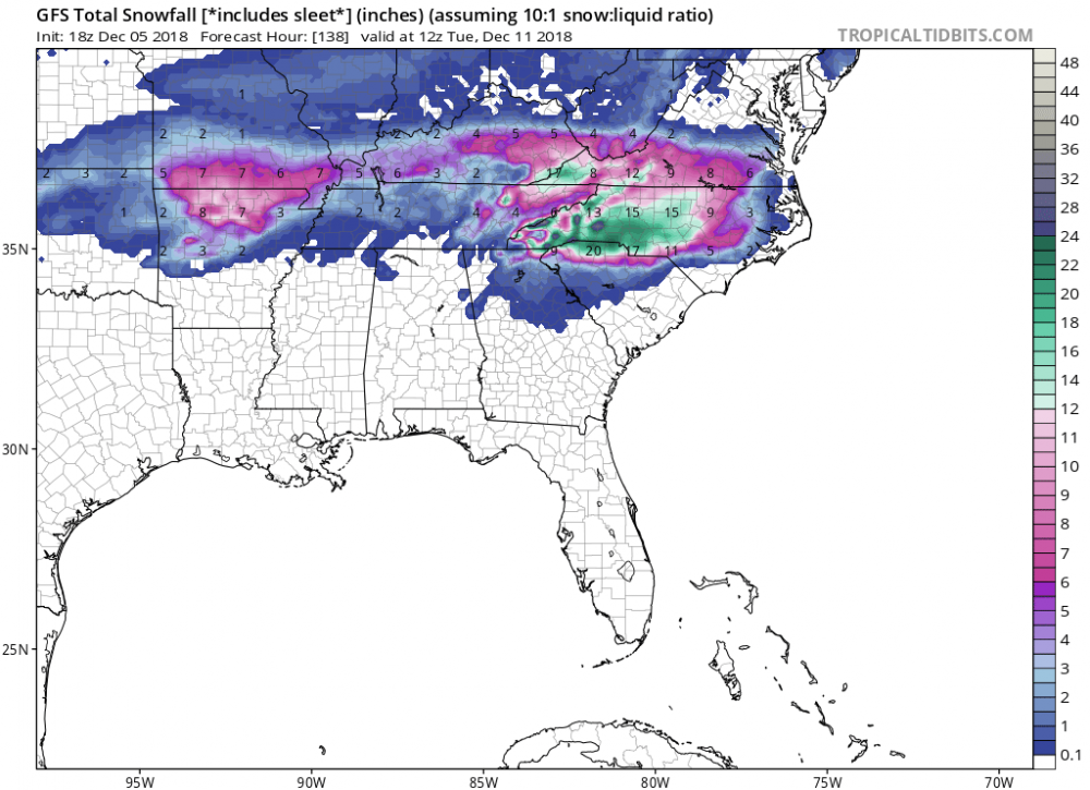
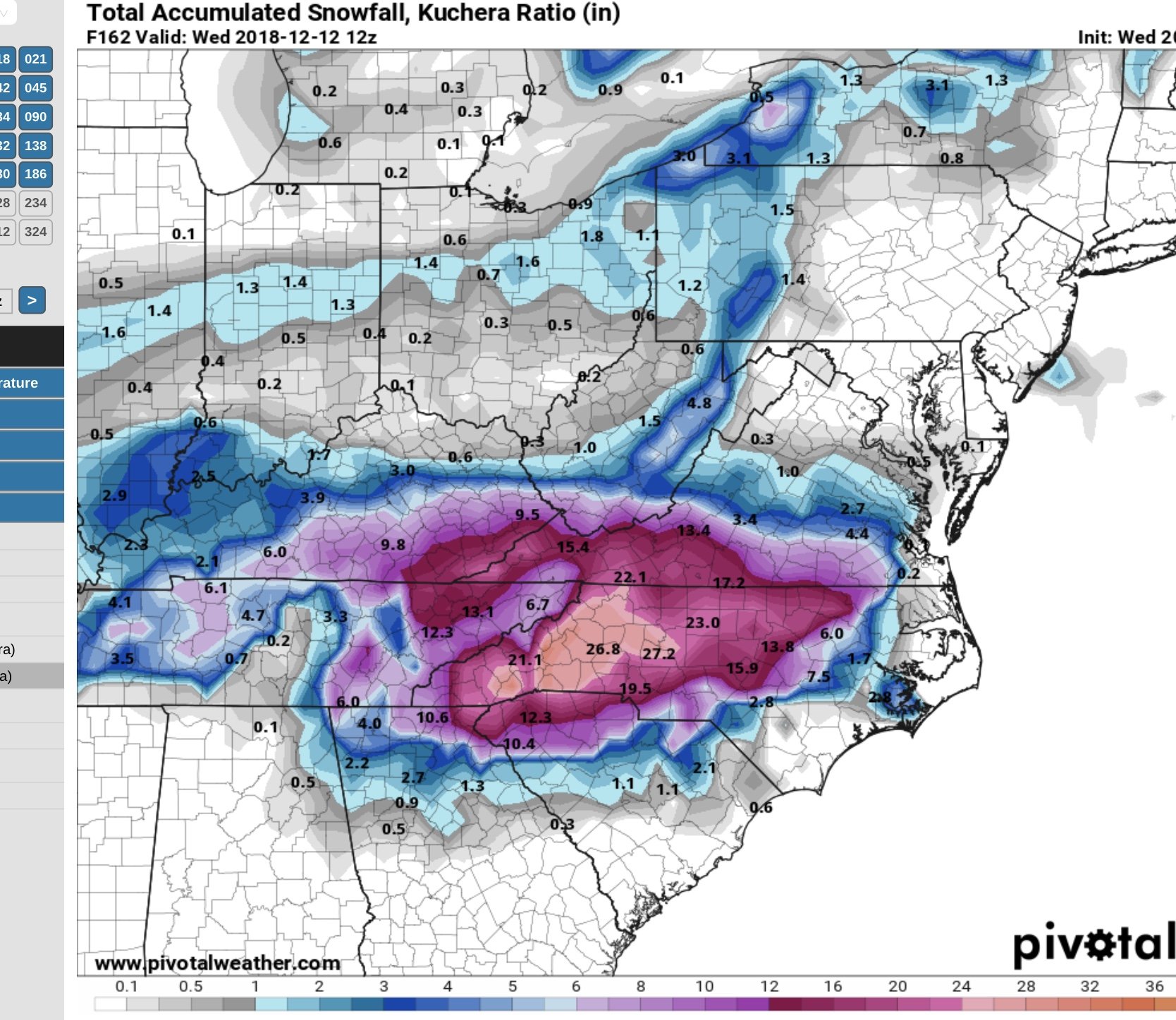
7 inches from Wake westward in NC.
.thumb.png.cabe6d3d069ef7ff429d5e73c0176ef6.png)
-
Well, if we are within 24 hours and the models are about the same as they are now, and it ends up like RAH says, then the technology really needs to be improved with regards to the models.
-
3
-
-
2 minutes ago, Solak said:
RAH:
Sat through Mon night: A significant wintertime storm for NC is
growing more likely with every model run. Differences among the
models regarding timing, track, precip amounts, and the vertical
thermal structure and advection patterns persist, which makes any
details still difficult to pin down. But the chance of at least some
wintry precip over the central NC forecast area with this event is
growing.

-Synopsis: A potent mid-upper trough/low will cross the S Plains,
Gulf States, and Southeast during this period, as a surface low
tracks along the Gulf coast/S GA/FL Panhandle, likely evolving into
a Miller B configuration as this energy transfers to a deepening low
just off the Carolinas late Sun. This low should then intensify as
it tracks NE just off the NC coast through Mon. A second, strong
polar stream wave will dive through the Midwest Sat night through
Sun night and into the southern stream wave, prolonging the lift
over central NC as the column cools further.

-Timing: Following the slower ECMWF/Canadian/NAM solution over the
faster GFS, the heaviest precip is expected to fall from early
morning to late afternoon on Sun, in conjunction with strong upper
divergence and mid level DPVA. After this time, drying aloft and
waning forcing for ascent should mean a trend to lower precip rates.

-Ptype: Still appears to be mostly a rain event through Sun in areas
from the Triangle to the S and E, albeit with a little wintry precip
early in the event. For areas N and W of the Triangle, including the
Triad and most VA border counties, a wintry mix with some
accumulation is expected for most of the event through Sun, although
we may see a trend to mostly cold rain Sun afternoon. Some low level
drying is expected by Mon, but decent moisture and lift in the -12C
to -18C depth should result in a secondary chance of some light snow
or a wintry mix associated with the polar wave. It's too early for
specific amounts, but an inch or two is not out of the question in
the Triad region, with a non-zero chance of greater amounts. This
could change, however, especially given the sensitivity of precip
types to small changes in thermal structure and lift, so stay tuned.

-Temps: Expect highs in the upper 30s to mid 40s Sat and Mon, with
low 30s to upper 40s on Sun. Again, this is all predicated on
getting enough warm air into central NC to allow surface temps to
trend above freezing over the forecast area. Lows in the 30s.
An inch or two in the triad? Okay...
-
1
-
-
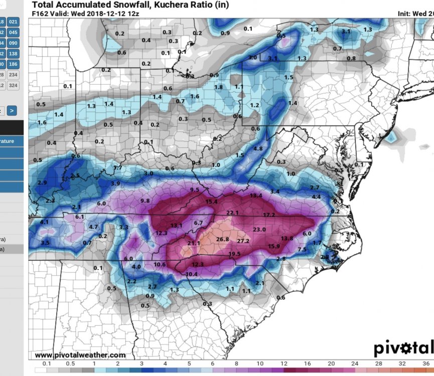
EPS mean is 7 to 9 across Wake. The gradient is diminished, too.
-
1
-
-
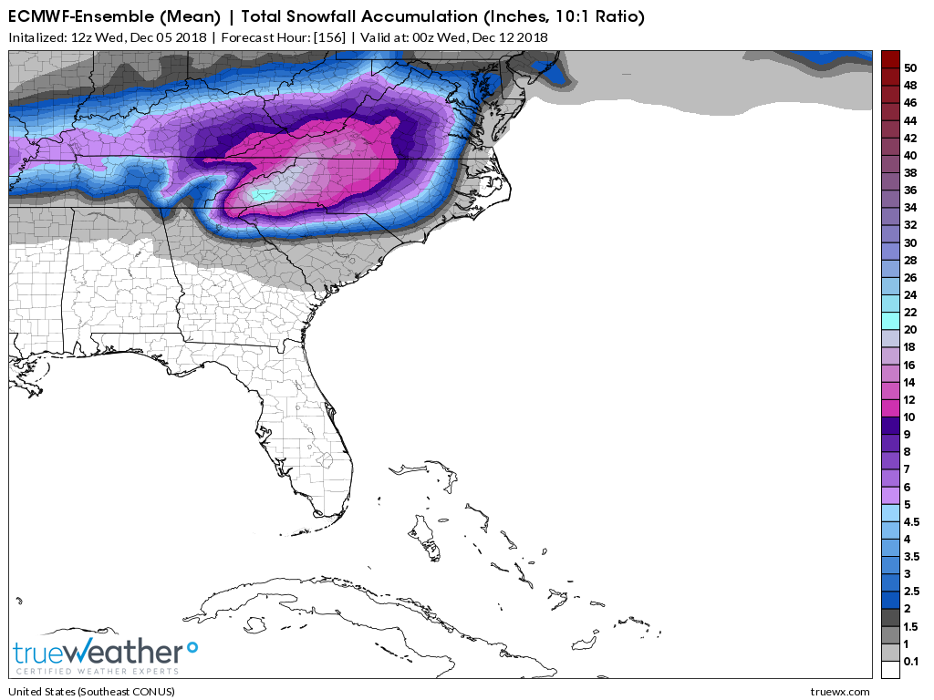
Euro ensembles mean is up.

-
8
-
-
The only question here appears to be what will the temps be during the event. I think the CAD could end up being stronger than modeled here, which would give us more frozen precip. I don't think it will be all snow, but will mix at times with sleet and freezing rain, but I could see it end up being more frozen precip than rain. A degree or two can make all the difference, as well as where exactly you are located when it comes to Wake County.
-
3
-
-
All the models showing a high impact event for most of NC, Raleigh and to the west. Still have three days to go, though.
-
2
-
-
2 minutes ago, Wow said:
12z GEFS snow totals individual panels. A lot more agreement for a big winter storm. Best chances still WNC.. still some members cutting north to hit the MA which would be an issue for eastern half of the state

Looks very consistent. I count 17 or 18 that I would consider a big storm for me.
-
Sure is nice to see the totals today actually be consistent or increase on most of the model runs instead of the other way around. Looks like most have anywhere from 6 to 12 inches across Wake.


.png.b3627b8b47796fee1862b7d9610eb56c.png)
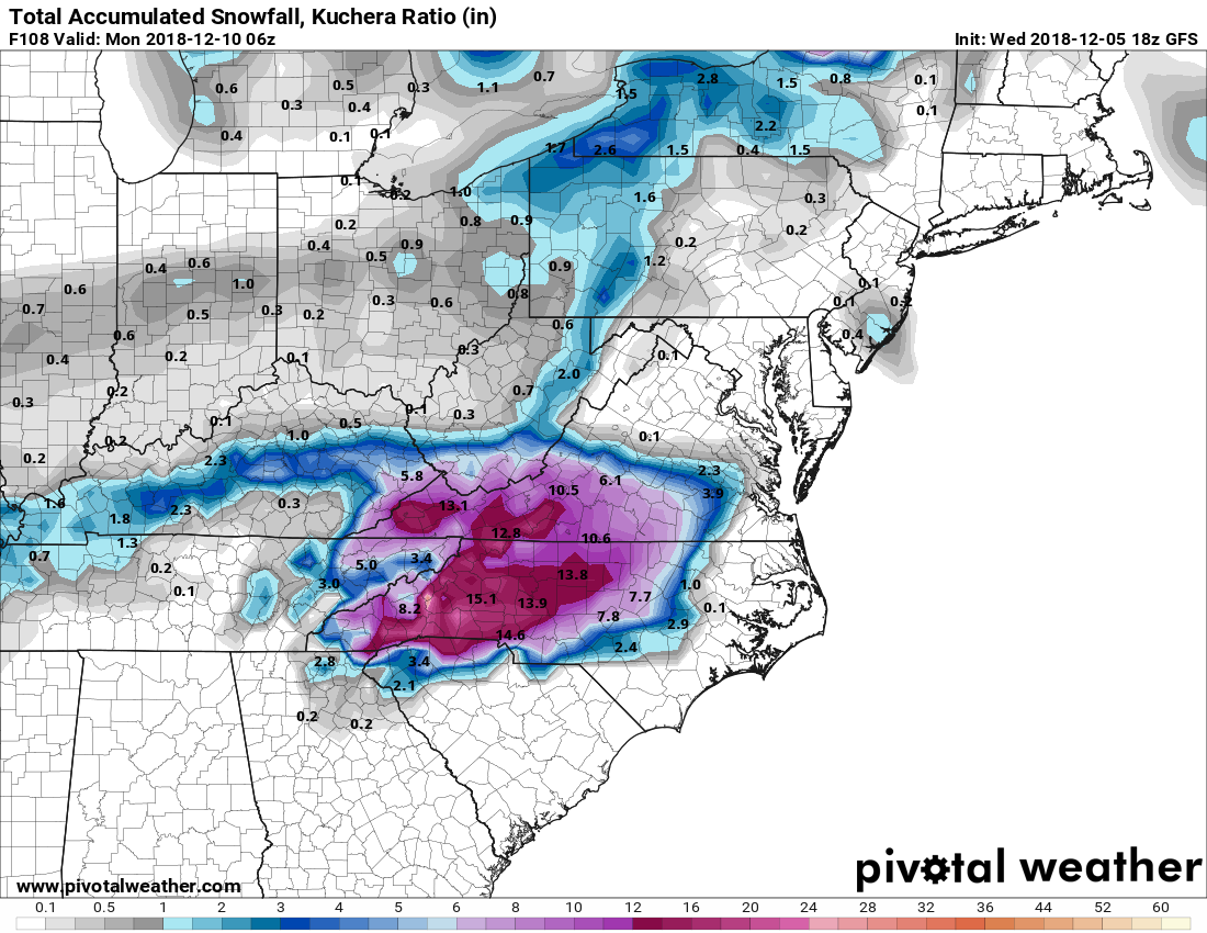
December 8-10, 2018 Winter Storm
in Southeastern States
Posted
Canadian went south, eh?