

Brick Tamland
-
Posts
12,210 -
Joined
-
Last visited
Content Type
Profiles
Blogs
Forums
American Weather
Media Demo
Store
Gallery
Posts posted by Brick Tamland
-
-
FV3 4 Life

-
1 minute ago, PackWxMan said:
Wow - thanks Fish. You just explained EVERY snow storm in Raleigh. Which ensembles is he referring to?
For those unfamiliar with Fish, he is typically the most conversative forecaster on earth
All the ensembles I have seen show Wake getting a big storm.
-
Just now, jkcraig said:
Fish just tweeted:
If you’re a snow lover in Wake County, you need to realize that there are many ways this system turns out to be a flop, and only a few ways for it to be a big snowstorm. This is precisely why we have taken the ensemble based probabilistic approach we have taken all week.
They would take the same approach no matter what.
-
 2
2
-
 1
1
-
-
3 hours ago, ajr said:
 WRAL snowfall map - seems bullish to me
3 hours ago, GreensboroWx said:
WRAL snowfall map - seems bullish to me
3 hours ago, GreensboroWx said:Based on what I have seen with the overnight runs, I think it might be a bit conservative.
I'd put 3 to 6 in the 1 to 3 and 6 to 10 in the 3 to 5 to be on the safe side
-
1 minute ago, BIG FROSTY said:
Y'all can have any model you like, but I'm claiming the CMC
")

I'll take any of the models. Most appear to have 6 to 12 inches of snow for me. Heck, I'd take about 4 inches of snow and some ice mixed in, too.
-
Just now, PackWxMan said:
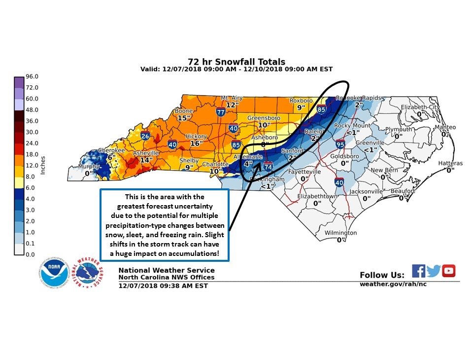
That area they have circled looks too conservative to me. I think at least 4 to 6 of snow with ice on top.
-
1 minute ago, FallsLake said:
We're going to be on the line for some type of transition. Hopefully that snow line stays south and east as long as it can. But agreeing with your point, we know our area well; I would think we get a good initial thumping of snow and then it goes to ice. **and then rain for some and then back to a little wintery precip before it ends.
I think we could get 6 to 8 of snow with some ice on top.
-
-
2 minutes ago, Wow said:
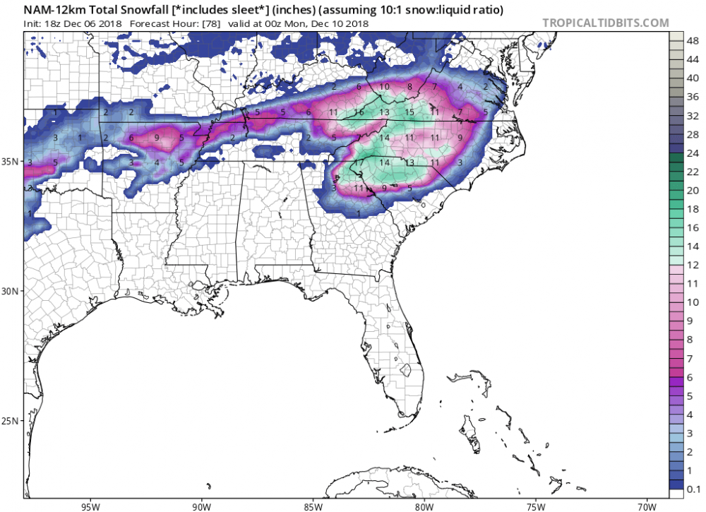
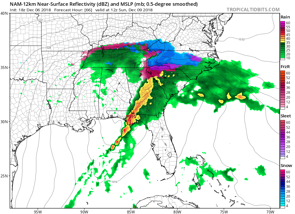
NAM has caved to the FV3 and its allies. Flatter, weaker southern wave. Less WAA, less GOM convection moisture robbing thus no dry slot. Good stuff.
If the FV3 got this right, the totals will be huge. It has been very consistent.
-
The model runs continue to look fantastic. Great to see them stay consistent or get even better the closer we get.
-
2
-
-
1 minute ago, Cold Rain said:
Ok good deal. Why do you think there won’t be much warming aloft?
I just don't. Why do you think it will be?
-
1
-
1
-
-
24 minutes ago, Cold Rain said:
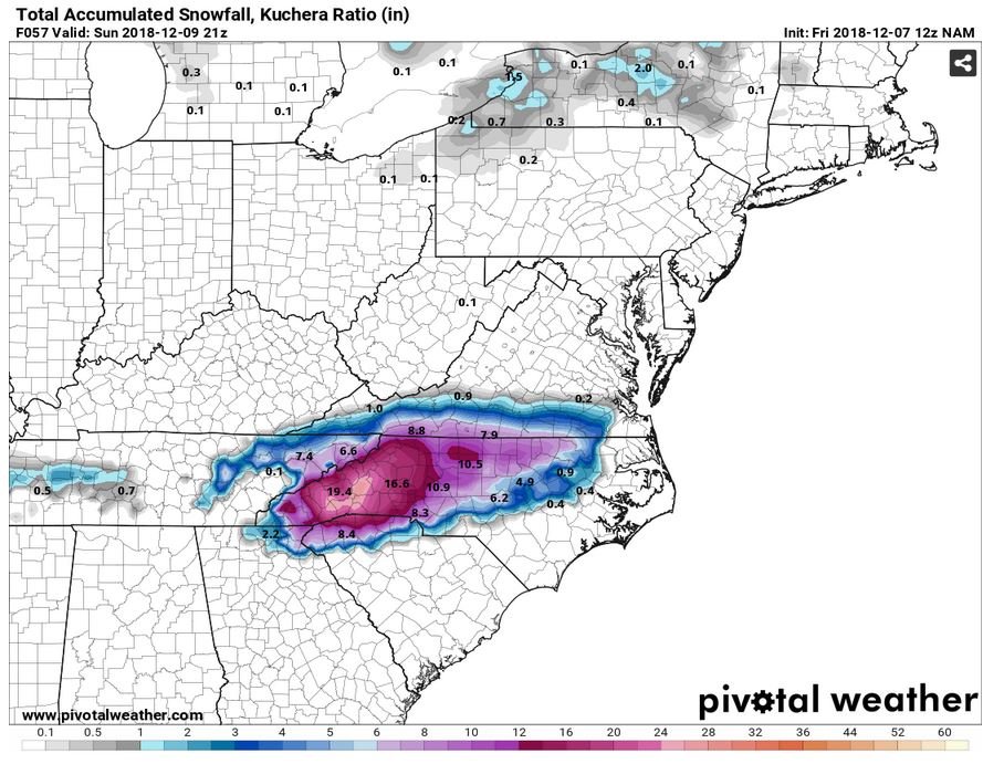
I think we can all agree that the extended ranges of the NAM are suspect and that it’s snow map on TT is ridiculous. But there is going to be warming aloft here. And it will be warmer and more extensive than the globals are showing. For many in central NC, assuming we don’t have a convection moisture robbing situation (which is possible), there is going to be a lot of sleet and ZR, even back into the Triad and into parts of VA.
I don't think the warming aloft will be as bad as you think. I think we will get a good thump of snow like Allan said, 4 to 6 inches, before getting some ice on top of it.
-
1
-
-
26 minutes ago, jburns said:
Just remember, without Bricks you can't build a decent ****house.
Naw, y'all got that here already.
-
1
-
-
9 minutes ago, Blue_Ridge_Escarpment said:
With Euro being the most consistent model for this storm will credence be given to that model going forward? Considering it’s in the euro wheel house right now. Thanks for answering these for us!
Euro and FV3 have both been very consistent with their outputs the last two days.
-
It is coming
-
Great, the other mod comes in and deletes my comment that was on topic just as much as others. Guess some things never change.
-
2
-
-
So really this is coming down to the globals vs. the NAM. But even the NAM looked better last run.
-
1
-
-
The globals are not backing down at all.
-
12 minutes ago, sarcean said:
wow
RAH call map

I would gladly take 3 to 5 inches with the first storm threat of the season.
-
1
-
-
1 minute ago, FallsLake said:
Yeah, its got .82" of freezing rain at RDU.
So, either that much freezing rain, 8 inches of snow, or 4 inches of snow and .40 of freezing rain is going to be a big deal.
-
3 minutes ago, wncsnow said:
That map is highly inaccurate with all of the sleet and ZR included
Even if it isn't all snow, that is still a big storm regardless with snow and ice mix.
-
2 minutes ago, Solak said:
RAH just wrote a book!
.LONG TERM /SATURDAY THROUGH THURSDAY/...
As of 330 PM Thursday...

...A significant winter storm is expected Sat night through Mon;
a winter storm watch is being issued for the NW Piedmont...

Overview for Sat-Mon: A significant wintertime storm for NC is
growing more likely with every model run. Differences among the
models regarding timing, track, precip amounts, and the vertical
thermal structure and advection patterns persist, which makes it
challenging to pinpoint the details, but the models are coming into
better agreement now. It's very likely that parts of central NC,
primarily N and W of the Triangle, will see several inches of snow,
at least, along with some icing. Lesser (but still impactful)
accumulations of ice and snow are expected at some point of the
event over all but the far SE.

-Synopsis: A potent mid-upper trough/low will cross the S Plains,
Gulf States, and Southeast during this period, as a surface low
tracks along the Gulf Coast/S GA/FL Panhandle, evolving into a
Miller B configuration as this energy transfers to a deepening low
just off GA/SC on Sun. This low should then intensify as it tracks
NE just off the NC coast through Mon. A second, strong polar stream
wave will dive through the Midwest and lower Miss Valley Sat night
through Mon, shearing across the Southeast states and prolonging the
lift and moisture over central NC as yet another deepening low
pressure center holds just off NC.

-Timing: Model agreement has improved since yesterday, with the
ECMWF/Canadian still the preferred solution, while the NAM is quite
close and the GFS still a fast solution. Leaning toward the
ECMWF/Canadian/NAM, have brought chance pops gradually into the SW
CWA on Sat, expanding slowly to the N and NE late day and overnight.
The heaviest precip is expected to fall from early Sun morning to
mid afternoon Sun, in conjunction with the most intense upper
divergence/mid level DPVA and most vigorous and deepest moist
upglide. After this time, drying aloft (in the -12C to -18C layer)
and waning forcing for ascent should mean a trend to lower precip
rates, although high pops will persist.

-Precip types: Increased confidence in a cold column has prompted
expansion of the areas likely to be impacted by wintry weather. The
far SE is still likely to see mostly rain through Sun, albeit with a
little wintry precip early in the event and again on Mon. Roughly
along the Highway 1 corridor including the Triangle, a longer
duration of a wintry mix is anticipated, with a light glazing
possible along with some snow and/or sleet accumulation ranging from
one half inch to a few inches (this is the area that could see a
tight gradient of lighter to heavier accumulations over a short
distance). We could see a trend to a cold rain sometime on Sun in
this zone, if low level warm advection on the N side of the coastal
low becomes more prominent. For the NW Piedmont including the Triad,
snow and sleet will be the predominant precip type for most of the
event, with accumulations from several inches to just under a foot
not out of the question. Some low level drying is expected by Mon,
but continued lift and moisture in the -12C to -18C depth should
result in a secondary chance of some light snow or a wintry mix
associated with the polar wave and some additional light
accumulations.

-Temps: Expect highs in the upper 30s to mid 40s Sat and Mon, with
around 30 to the mid 40s for highs on Sun. Lows will be mainly in
the upper 20s to mid 30s. The diurnal range in most areas will be
very low.

-What to watch out for/what could change: First, the inland
penetration of warm air on the N side of coastal lows is always
problematic. This could cause a significant warm nose to develop
aloft, shifting snow over to more sleet or freezing rain in some
areas. Second, if surface temperatures don't warm up as advertised
on Sun, especially along and E of the Highway 1 corridor, wintry
precip could last longer, increasing accumulations of both snow and
ice. Third, there are indications in the models that a band of
heavier convective precip is possible over the Southeast, just
inland to just off the Southeast coast, and this could serve to
interrupt transport of high moisture into central NC; if this were
to occur, liquid equivalent precip amounts would be lower. Finally,
if we can achieve banded snow at any point in this event, we could
potentially see localized zones of very heavy snowfall over portions
of the Piedmont.
At least now they are saying a big storm could be a possibility instead of 1 to 2 inches.
-
Big turnaround with the NAM.
-
2
-
1
-
-
NAM looking good so far.

-
2
-

December 8-10, 2018 Winter Storm
in Southeastern States
Posted
Noted